NOAA Retires GOES-13 Satellite After 10 Years of Stellar Service
Special Stories
15 Jan 2018 8:26 AM
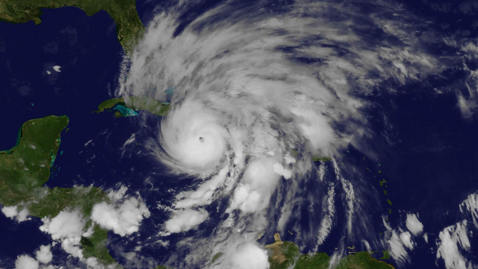
[GOES-13 view of Hurricane Sandy intensifying the Caribbean Sea before the storm tracked up the U.S. East Coast in October 2012.]
From NOAA NESDIS
Makes way for next generation of weather imagery! NOAA’s GOES-13 satellite has captured some of the most notorious weather events in recent U.S. history – from paralyzing blizzards in the Northeast and Midwest, to destructive hurricanes like Sandy in 2012 and last summer’s historic run of Hurricane Harvey, Irma and Maria.
https://www.youtube.com/watch?v=xHm7oh0Yn60
But with the emergence of the next-generation GOES-16 as NOAA’s new GOES-East satellite, GOES-13, which held the position since April 2010, was powered down recently on January 8, 2018. It can be reactivated if one of NOAA’s other operational or backup satellites experiences trouble.
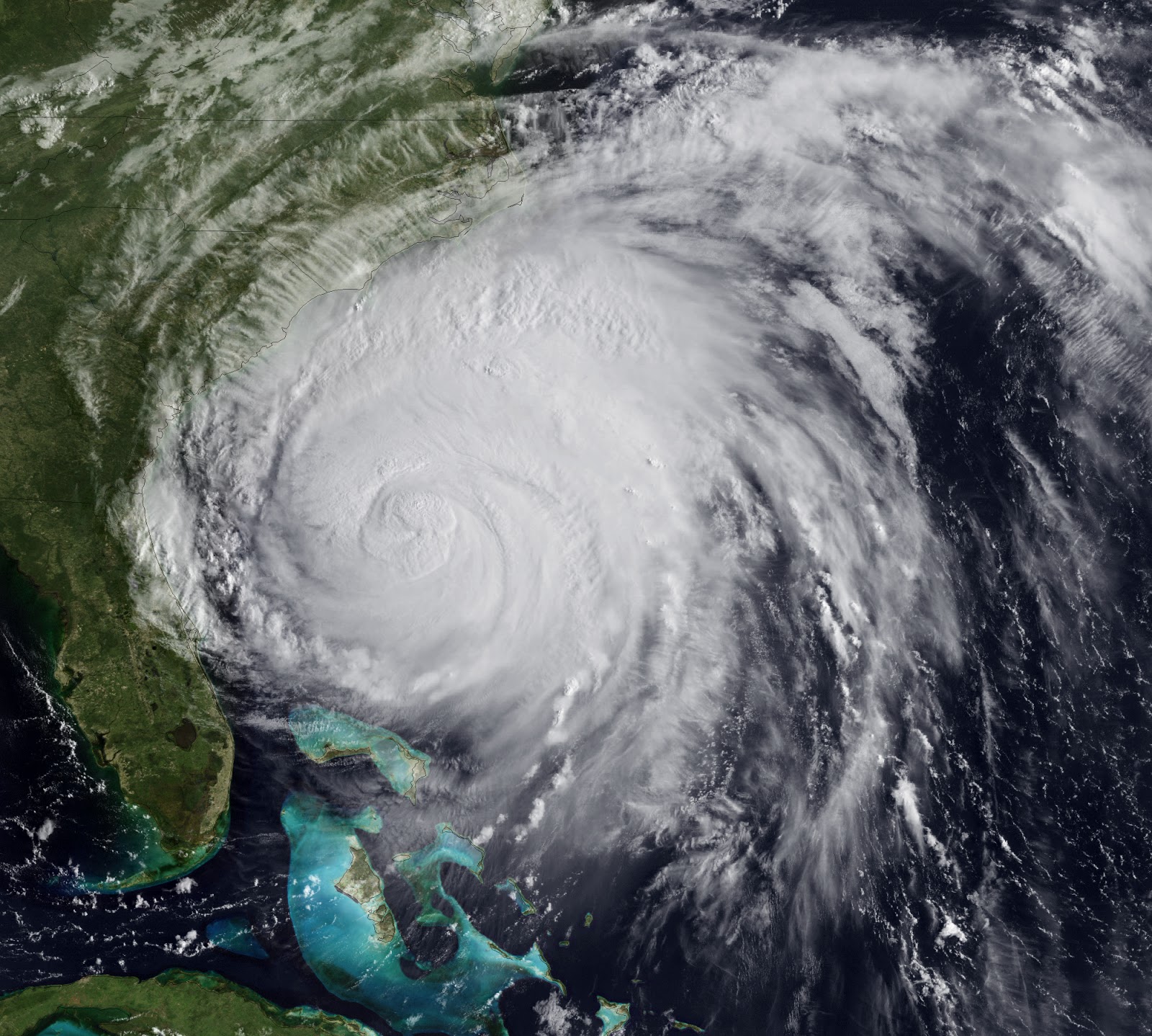
 [NOAA GOES-13 captured this image of Hurricane Irma at 7:07 p.m. EDT on September 10, 2017, when the eye of the storm was just southeast of Fort Myers.]
“GOES-13 was a reliable work horse, supplying meteorologists with the crucial imagery and data, which enabled NOAA to provide accurate forecasts and warnings of storms, many of which are in the record books,” said retired Navy Rear Adm. Timothy Gallaudet, Ph.D., acting NOAA administrator.
[NOAA GOES-13 captured this image of Hurricane Irma at 7:07 p.m. EDT on September 10, 2017, when the eye of the storm was just southeast of Fort Myers.]
“GOES-13 was a reliable work horse, supplying meteorologists with the crucial imagery and data, which enabled NOAA to provide accurate forecasts and warnings of storms, many of which are in the record books,” said retired Navy Rear Adm. Timothy Gallaudet, Ph.D., acting NOAA administrator.
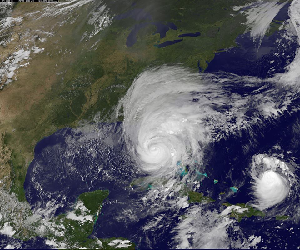
 [This image of Harvey was taken from GOES-13 at 3 pm EDT on August 25, 2017.]
A previous NOAA geostationary satellite, GOES-14, also deactivated, will remain NOAA’s primary back-up satellite, and can be activated if either GOES-16 or GOES-15, the current GOES-West satellite, experiences technical difficulties.
[This image of Harvey was taken from GOES-13 at 3 pm EDT on August 25, 2017.]
A previous NOAA geostationary satellite, GOES-14, also deactivated, will remain NOAA’s primary back-up satellite, and can be activated if either GOES-16 or GOES-15, the current GOES-West satellite, experiences technical difficulties.
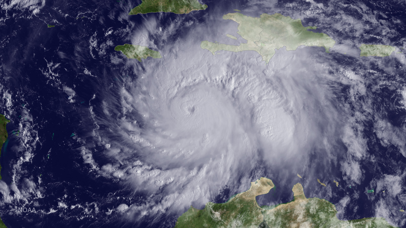 [GOES-13 view of Hurricane Matthew in the Caribbean, before the storm decimated Haiti, October 3, 2016.]
The next next-generation satellite, NOAA’s GOES-S is scheduled for launch on March 1, and will become the new GOES-West satellite after a checkout and testing phase, which can take up to a year. Forecasters will be able to take advantage of its advanced imagery during that phase-in time. Together, these satellites will enable NOAA to more closely monitor weather systems over North America, South America, and the Atlantic and Pacific Oceans to help protect lives and property.
[GOES-13 view of Hurricane Matthew in the Caribbean, before the storm decimated Haiti, October 3, 2016.]
The next next-generation satellite, NOAA’s GOES-S is scheduled for launch on March 1, and will become the new GOES-West satellite after a checkout and testing phase, which can take up to a year. Forecasters will be able to take advantage of its advanced imagery during that phase-in time. Together, these satellites will enable NOAA to more closely monitor weather systems over North America, South America, and the Atlantic and Pacific Oceans to help protect lives and property.
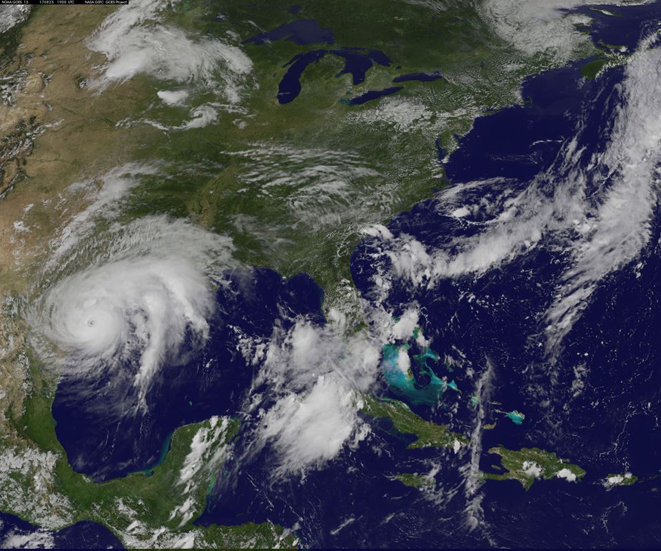
 [GOES-13 captures Hurricane Irene track up the U.S. East Coast on August 26, 2011.]
In addition to the geostationary satellites, NOAA also operates a fleet of polar-orbiting satellites. The first of NOAA’s next-generation polar satellites, NOAA-20, launched November 18, 2017. Both types of satellites form the backbone of NOAA’s increasingly accurate weather forecasts.
[GOES-13 captures Hurricane Irene track up the U.S. East Coast on August 26, 2011.]
In addition to the geostationary satellites, NOAA also operates a fleet of polar-orbiting satellites. The first of NOAA’s next-generation polar satellites, NOAA-20, launched November 18, 2017. Both types of satellites form the backbone of NOAA’s increasingly accurate weather forecasts.
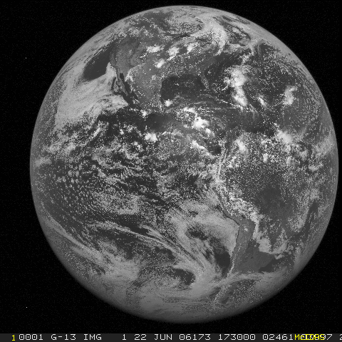 [First GOES-13 Full Disk Image, June 22, 2006.]
Edited for WeatherNation by Meteorologist Mace Michaels
[First GOES-13 Full Disk Image, June 22, 2006.]
Edited for WeatherNation by Meteorologist Mace Michaels
[NOAA GOES-13 captured this image of Hurricane Irma at 7:07 p.m. EDT on September 10, 2017, when the eye of the storm was just southeast of Fort Myers.]
“GOES-13 was a reliable work horse, supplying meteorologists with the crucial imagery and data, which enabled NOAA to provide accurate forecasts and warnings of storms, many of which are in the record books,” said retired Navy Rear Adm. Timothy Gallaudet, Ph.D., acting NOAA administrator.
[This image of Harvey was taken from GOES-13 at 3 pm EDT on August 25, 2017.]
A previous NOAA geostationary satellite, GOES-14, also deactivated, will remain NOAA’s primary back-up satellite, and can be activated if either GOES-16 or GOES-15, the current GOES-West satellite, experiences technical difficulties.
[GOES-13 view of Hurricane Matthew in the Caribbean, before the storm decimated Haiti, October 3, 2016.]
The next next-generation satellite, NOAA’s GOES-S is scheduled for launch on March 1, and will become the new GOES-West satellite after a checkout and testing phase, which can take up to a year. Forecasters will be able to take advantage of its advanced imagery during that phase-in time. Together, these satellites will enable NOAA to more closely monitor weather systems over North America, South America, and the Atlantic and Pacific Oceans to help protect lives and property.
[GOES-13 captures Hurricane Irene track up the U.S. East Coast on August 26, 2011.]
In addition to the geostationary satellites, NOAA also operates a fleet of polar-orbiting satellites. The first of NOAA’s next-generation polar satellites, NOAA-20, launched November 18, 2017. Both types of satellites form the backbone of NOAA’s increasingly accurate weather forecasts.
[First GOES-13 Full Disk Image, June 22, 2006.]
Edited for WeatherNation by Meteorologist Mace MichaelsAll Weather News
More
More Storms for the East Through Monday
A low-pressure system that moved through the
3 Aug 2026 12:20 PM


After Reaching Category 5, Genevieve Weakens in the Pacific
PacificGenevieve formed last Friday south of
3 Aug 2026 12:30 AM

Flooding, Severe Storms Target the Midwest Again
After an active week of storms across the nor
1 Aug 2026 1:40 AM

Flooding Risk Increases as Heavy Rain Targets the Tri-State Area
Tuesday, heavy rainfall moved across the Nort
30 Jul 2026 12:25 AM

Severe Weather: Energy From the Midwest Now in the Southeast
UPPER MIDWEST - Through Monday, dangerous tor
29 Jul 2026 10:30 PM