NOAA Satellites Keep Watch when Weather Gets Weird
Special Stories
28 Mar 2018 7:59 AM
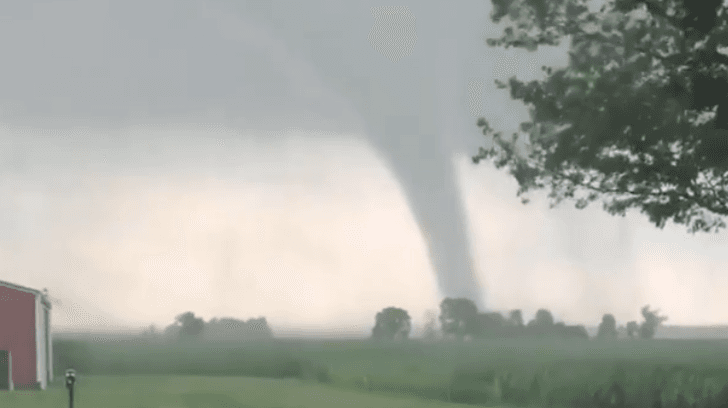
[Tornado near Logansport, Indiana from July 10th, 2017. Photo Credit: Eric Bell]
From NOAA
From thundersnow to upwards striking lightning, weather on Planet Earth can get pretty weird and NOAA’s fleet of satellites has seen it all!
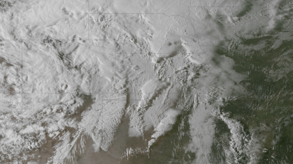 [NOAA GOES-13 Captures Large Areas of Freezing Rain over the Central Plains, April 9, 2013.]
One of the more dangerous weather conditions that affects the United States is freezing rain. When it’s really cold outside (below 32 degrees Fahrenheit) and there is moisture coming down from clouds, we typically expect to see snow. Sometimes, the air temperature at the ground is below freezing, but the temperature above the ground is much warmer. When this occurs rain freezes as it hits the ground and becomes freezing rain. The layer of freezing air is so thin that raindrops don't have time to freeze until reaching the ground surface where they create ice.
Here’s the simple science: liquid raindrops in a layer of warm air well above the surface fall into a layer of freezing air hugging the ground. The water freezes on contact with the surface, creating a coating of ice on whatever the raindrops contact.
In the image above from April 9, 2013 the NOAA GOES-13 satellite captured a cold air mass surging south and east across the Central Plains, which set the stage for heavy snow and mixed precipitation. Deep moisture from the Gulf of Mexico in place ahead of the cold front was drawn over the colder surface temperatures resulting in a broad area of freezing rain.
[NOAA GOES-13 Captures Large Areas of Freezing Rain over the Central Plains, April 9, 2013.]
One of the more dangerous weather conditions that affects the United States is freezing rain. When it’s really cold outside (below 32 degrees Fahrenheit) and there is moisture coming down from clouds, we typically expect to see snow. Sometimes, the air temperature at the ground is below freezing, but the temperature above the ground is much warmer. When this occurs rain freezes as it hits the ground and becomes freezing rain. The layer of freezing air is so thin that raindrops don't have time to freeze until reaching the ground surface where they create ice.
Here’s the simple science: liquid raindrops in a layer of warm air well above the surface fall into a layer of freezing air hugging the ground. The water freezes on contact with the surface, creating a coating of ice on whatever the raindrops contact.
In the image above from April 9, 2013 the NOAA GOES-13 satellite captured a cold air mass surging south and east across the Central Plains, which set the stage for heavy snow and mixed precipitation. Deep moisture from the Gulf of Mexico in place ahead of the cold front was drawn over the colder surface temperatures resulting in a broad area of freezing rain.
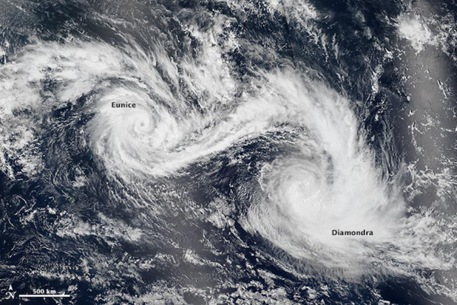 [Tropical Cyclone Eunice (left) and Tropical Cyclone Diamondra (right) in the Southern Indian Ocean on Jan. 28, 2015. On January 28, 2015, the Visible Infrared Imaging Radiometer Suite (VIIRS) on Suomi NPP captured the lower image composite. Credit: NASA]
Tropical Cyclone Eunice (left) and Tropical Cyclone Diamondra (right) in the Southern Indian Ocean on Jan. 28, 2015. On January 28, 2015, the Visible Infrared Imaging Radiometer Suite (VIIRS) on Suomi NPP captured the lower image composite. Credit: NASA
Hurricanes and tropical cyclones are massive powerful storms that can cause millions of dollars of damage, but occasionally two storms of hurricane strength can merge together.
Here’s the simple science: known as the Fujiwhara Effect, this occurs when two nearby tropical cyclones rotate around each other and begin to interact and influence each other. If one hurricane is a lot stronger than the other, the smaller one will orbit it and eventually come crashing into its vortex to be absorbed. Two storms closer in strength can gravitate towards each other until they reach a common point and merge, or merely spin each other around for a while before shooting off on their own paths. But often, the effect is additive when hurricanes come together — we usually end up with one massive storm instead of two smaller ones.
Some weather forecasting models suggested that this might occur when Hurricanes Maria and Jose approached each other in the Atlantic Ocean in September 2017, but the storms stayed too far apart. The Fujiwhara Effect is more common in the Pacific Ocean than the Atlantic.
As a world leader in hurricane research, NOAA strives to understand the mechanics of these complex interactions in order to protect people, property, commerce, and natural resources.
[Tropical Cyclone Eunice (left) and Tropical Cyclone Diamondra (right) in the Southern Indian Ocean on Jan. 28, 2015. On January 28, 2015, the Visible Infrared Imaging Radiometer Suite (VIIRS) on Suomi NPP captured the lower image composite. Credit: NASA]
Tropical Cyclone Eunice (left) and Tropical Cyclone Diamondra (right) in the Southern Indian Ocean on Jan. 28, 2015. On January 28, 2015, the Visible Infrared Imaging Radiometer Suite (VIIRS) on Suomi NPP captured the lower image composite. Credit: NASA
Hurricanes and tropical cyclones are massive powerful storms that can cause millions of dollars of damage, but occasionally two storms of hurricane strength can merge together.
Here’s the simple science: known as the Fujiwhara Effect, this occurs when two nearby tropical cyclones rotate around each other and begin to interact and influence each other. If one hurricane is a lot stronger than the other, the smaller one will orbit it and eventually come crashing into its vortex to be absorbed. Two storms closer in strength can gravitate towards each other until they reach a common point and merge, or merely spin each other around for a while before shooting off on their own paths. But often, the effect is additive when hurricanes come together — we usually end up with one massive storm instead of two smaller ones.
Some weather forecasting models suggested that this might occur when Hurricanes Maria and Jose approached each other in the Atlantic Ocean in September 2017, but the storms stayed too far apart. The Fujiwhara Effect is more common in the Pacific Ocean than the Atlantic.
As a world leader in hurricane research, NOAA strives to understand the mechanics of these complex interactions in order to protect people, property, commerce, and natural resources.
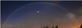 We will leave you with this parting shot - a moonbow. This is not an image one of our satellites captured, it comes to us from the National Weather Service office in Honolulu. All rainbows are beautiful, but not all occur during the day. A moonbow, also known as a lunar rainbow, is caused by the same optical phenomenon as a typical rainbow: light being refracted through water droplets in the air. Very rarely, a full moon will produce enough light for our eyes to see a faint ‘moonbow’ across the sky.
Edited for WeatherNation by Meteorologist Mace Michaels
We will leave you with this parting shot - a moonbow. This is not an image one of our satellites captured, it comes to us from the National Weather Service office in Honolulu. All rainbows are beautiful, but not all occur during the day. A moonbow, also known as a lunar rainbow, is caused by the same optical phenomenon as a typical rainbow: light being refracted through water droplets in the air. Very rarely, a full moon will produce enough light for our eyes to see a faint ‘moonbow’ across the sky.
Edited for WeatherNation by Meteorologist Mace Michaels
Thundersnow
https://www.youtube.com/watch?v=j_vxcJwcFes “Thundersnow” is a rare weather phenomena in which thunder and lightning are accompanied predominantly by snow rather than rain. Thundersnow occurs where there is relatively strong instability and abundant moisture above the surface of the Earth, such as above a warm front. The ingredients that create thundersnow are similar to the dynamics of a typical thunderstorm -- moisture, instability, and a lifting mechanism. Here's the simple science: air is considered unstable if it continues to rise on its own after getting a nudge from a cold front or warm front. This rarely occurs when it’s snowing because the air temperature in winter snow storms is consistently cold, at both high and lower points in the atmosphere. However, in some winter storms, shallow layers of warm air are lifted and continue to rise on their own - increasing snowfall and causing enough electric charge separation for lighting to occur. In March 2018 the East Coast experienced three back-to-back nor’easter winter storms within ten days. The NOAA GOES East (GOES-16) satellite Geostationary Lightning Mapper captured the lightning from these events which produced thundersnow. Tracking lightning during a snowstorm is a critical tool to help meteorologists because thundersnow is typically associated with increased snowfall amounts.Freezing Rain
[NOAA GOES-13 Captures Large Areas of Freezing Rain over the Central Plains, April 9, 2013.]
One of the more dangerous weather conditions that affects the United States is freezing rain. When it’s really cold outside (below 32 degrees Fahrenheit) and there is moisture coming down from clouds, we typically expect to see snow. Sometimes, the air temperature at the ground is below freezing, but the temperature above the ground is much warmer. When this occurs rain freezes as it hits the ground and becomes freezing rain. The layer of freezing air is so thin that raindrops don't have time to freeze until reaching the ground surface where they create ice.
Here’s the simple science: liquid raindrops in a layer of warm air well above the surface fall into a layer of freezing air hugging the ground. The water freezes on contact with the surface, creating a coating of ice on whatever the raindrops contact.
In the image above from April 9, 2013 the NOAA GOES-13 satellite captured a cold air mass surging south and east across the Central Plains, which set the stage for heavy snow and mixed precipitation. Deep moisture from the Gulf of Mexico in place ahead of the cold front was drawn over the colder surface temperatures resulting in a broad area of freezing rain.
Merging Hurricanes
[Tropical Cyclone Eunice (left) and Tropical Cyclone Diamondra (right) in the Southern Indian Ocean on Jan. 28, 2015. On January 28, 2015, the Visible Infrared Imaging Radiometer Suite (VIIRS) on Suomi NPP captured the lower image composite. Credit: NASA]
Tropical Cyclone Eunice (left) and Tropical Cyclone Diamondra (right) in the Southern Indian Ocean on Jan. 28, 2015. On January 28, 2015, the Visible Infrared Imaging Radiometer Suite (VIIRS) on Suomi NPP captured the lower image composite. Credit: NASA
Hurricanes and tropical cyclones are massive powerful storms that can cause millions of dollars of damage, but occasionally two storms of hurricane strength can merge together.
Here’s the simple science: known as the Fujiwhara Effect, this occurs when two nearby tropical cyclones rotate around each other and begin to interact and influence each other. If one hurricane is a lot stronger than the other, the smaller one will orbit it and eventually come crashing into its vortex to be absorbed. Two storms closer in strength can gravitate towards each other until they reach a common point and merge, or merely spin each other around for a while before shooting off on their own paths. But often, the effect is additive when hurricanes come together — we usually end up with one massive storm instead of two smaller ones.
Some weather forecasting models suggested that this might occur when Hurricanes Maria and Jose approached each other in the Atlantic Ocean in September 2017, but the storms stayed too far apart. The Fujiwhara Effect is more common in the Pacific Ocean than the Atlantic.
As a world leader in hurricane research, NOAA strives to understand the mechanics of these complex interactions in order to protect people, property, commerce, and natural resources.
Upward Striking Lightning
https://www.youtube.com/watch?v=m7hecavQtTg [NOAA/NESDIS collaborates with many international partners to better understand the occurrence and implications of upward lightning. This high speed video was captured by Brazilian researcher Dr. Carina Schumann over Johannesburg, South Africa] The vast majority of lightning discharges around the world are "in-cloud" or "could-to-cloud" and the ones we see appear to strike from cloud to ground. However, ‘upward propagating discharges’ or upside-down lightning strikes, are possible, but extremely rare. When this happens, the lightning strike begins at the ground and then travels up towards the clouds.High-speed camera studies have shown upward lightning flashes to be more common than once thought. Here’s the simple science: these upward lightning strikes usually occur from tall towers, buildings or mountaintops and when there is a rapid change in atmospheric charges-right after a downward lightning strike occured. The creation of lightning is a complicated process. We generally know what conditions are needed to produce lightning, but there is still debate about exactly how a cloud builds up electrical charges and how lightning forms. Much has been learned regarding upward lightning, but uncertainty remains regarding the exact triggering mechanism.Over the Moonbow
We will leave you with this parting shot - a moonbow. This is not an image one of our satellites captured, it comes to us from the National Weather Service office in Honolulu. All rainbows are beautiful, but not all occur during the day. A moonbow, also known as a lunar rainbow, is caused by the same optical phenomenon as a typical rainbow: light being refracted through water droplets in the air. Very rarely, a full moon will produce enough light for our eyes to see a faint ‘moonbow’ across the sky.
Edited for WeatherNation by Meteorologist Mace MichaelsAll Weather News
More
Warmer Than Average: Above-Normal Temperatures Across the Central U.S. This Week
WHAT TO EXPECTA ridge of high pressure will b
22 Oct 2026 9:00 PM

Flooding & Severe Storms Target the Southwest
A low pressure system coming across the Weste
22 Oct 2026 8:55 PM


Tropical Storm Vance Forms In The Pacific
Isaias ended the late-season streak of no hur
22 Oct 2026 6:15 PM

Several Fires Break Out in SoCal Last Week Amid Santa Ana Wind Event
Santa Ana winds helped several fires grow qui
19 Oct 2026 1:25 PM

Another Cold Morning Before Things Warm Back Up
Across portions of the Ohio Valley through th
19 Oct 2026 10:15 AM

Severe Risk Diminishing Saturday Morning for the Northeast
Severe Storm PotentialSevere risk is decreasi
16 Oct 2026 10:20 AM