NOAA's Saildrone Observations for Improvement of Hurricane Intensity Forecasts
Special Stories
28 Jul 2021 2:00 AM
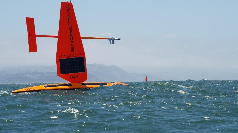
[Saildrones are uncrewed surface vehicles powered by wind and solar energy and remotely piloted via satellite telecommunication. They measure solar irradiance, barometric pressure, air temperature, humidity, wind, waves, water temperature, salinity, chlorophyll, dissolved oxygen and ocean current. They can also measure surface short- and long-wave radiation. The five saildrone of this deployment are specially designed for hurricane observations.]
[Written by NOAA PMEL] Improving the accuracy and ultimate value of NOAA's operational hurricane forecasts requires more complete real-time knowledge of atmospheric and oceanic conditions and more realistic representation of key physical processes in hurricane forecast models. To meet these needs, a research team from NOAA's Pacific Marine Environmental Laboratory (PMEL) and Atlantic Oceanographic and Meteorological Laboratory (AOML) plans to deploy five saildrones (see picture below) to observe conditions near the ocean surface during the 2021 Atlantic hurricane season.
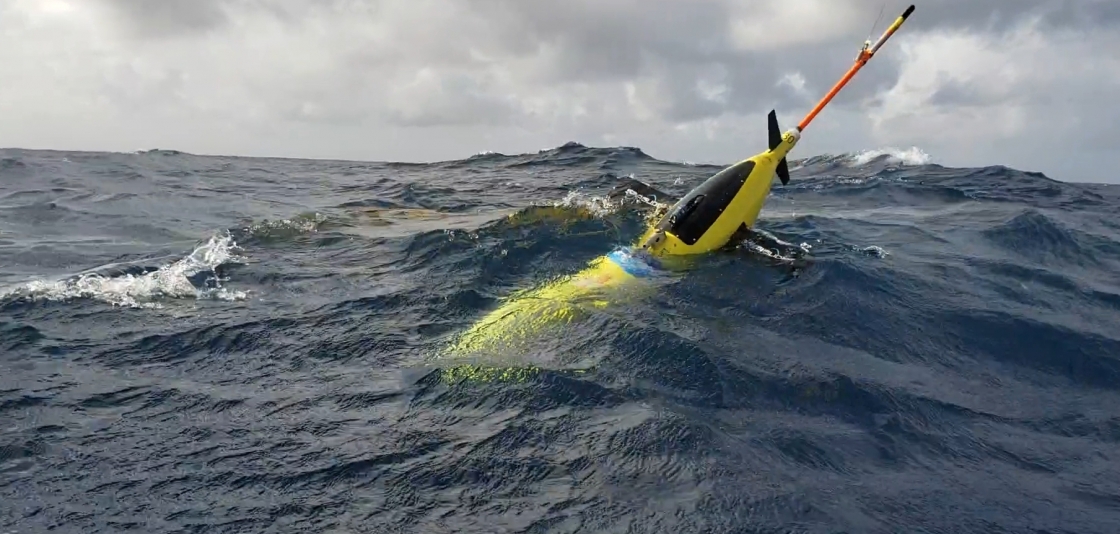 [Ocean gliders are uncrewed underwater vehicles powered by batteries. They measure water temperature, salinity, and currents from the surface down to 1000 m. They send their observations to satellites when they are at the ocean surface. There will be approximately 20 glider missions operating during the 2021 hurricane season, several of them operating in areas where the saildrones will take observations in order to provide quasi-collocated simultaneous observations of the ocean and atmosphere.]
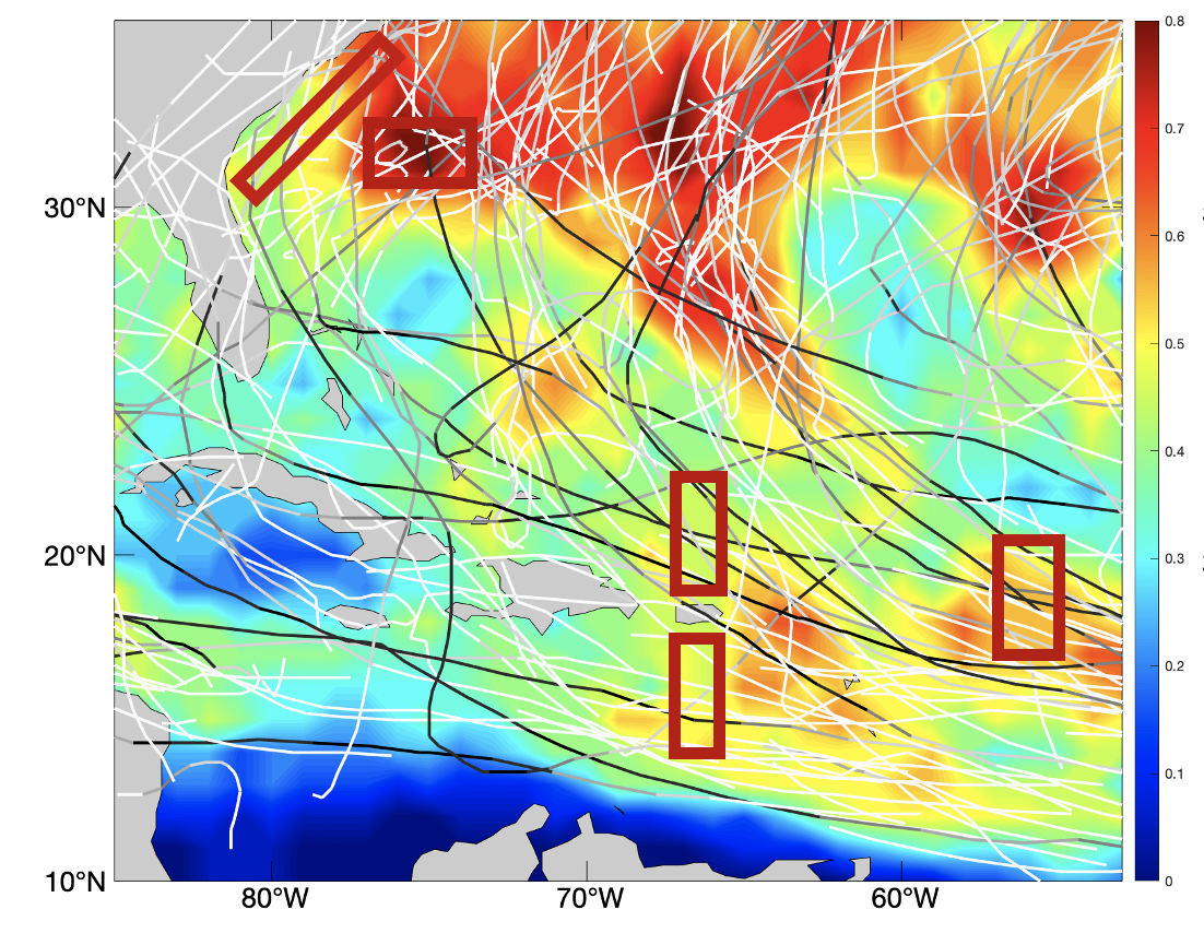 [The red boxes highlight the areas where saildrones will be deployed during August-October 2021. Lines are tracks of past category 5 hurricanes (black), other hurricanes (grey), and tropical storms (white). The background colors represent the probability of tropical storm force winds during August-October, based on data from 2000-2019.]
[Ocean gliders are uncrewed underwater vehicles powered by batteries. They measure water temperature, salinity, and currents from the surface down to 1000 m. They send their observations to satellites when they are at the ocean surface. There will be approximately 20 glider missions operating during the 2021 hurricane season, several of them operating in areas where the saildrones will take observations in order to provide quasi-collocated simultaneous observations of the ocean and atmosphere.]
Objectives
(1) Measure near-surface atmospheric and upper-ocean parameters to calculate energy and momentum fluxes between the atmosphere and ocean outside and within hurricanes. (2) Synchronize the deployments of saildrone and ocean gliders (see picture above) to measure the coupling between the surface atmosphere and upper ocean. (3) Transmit data in real-time to operational weather prediction centers to improve atmosphere-ocean initial conditions in forecast models. (4) Apply the observations to understand how air-sea interaction affects hurricane intensity and to advance hurricane prediction models.
[The red boxes highlight the areas where saildrones will be deployed during August-October 2021. Lines are tracks of past category 5 hurricanes (black), other hurricanes (grey), and tropical storms (white). The background colors represent the probability of tropical storm force winds during August-October, based on data from 2000-2019.]
Deployments
Saildrones will be deployed August 1-October 31, 2021 in five areas (highlighted by red boxes in the map below) where chances of hurricane occurrence are high. Observations will be sent to worldwide weather prediction centers in real time to assist their operational forecasts and will be made publicly available. This project also involves partnerships with NOAA's Environmental Modeling Center (EMC) of the National Weather Service and the CoastWatch of NOAA's National Environmental Satellite and Data Information Service (NESDIS).All Weather News
More
SW Low Moves East, Brings Flood Threat to the Plains
A powerful low pressure system has been movin
24 Oct 2026 1:10 AM

Hurricane Vance Strengthens In The Pacific
After becoming a hurricane Friday, Vance quic
24 Oct 2026 1:00 AM

Warmer Than Average: Above-Normal Temperatures Across the Central U.S. This Week
WHAT TO EXPECTA ridge of high pressure linger
24 Oct 2026 12:50 AM


Several Fires Break Out in SoCal Last Week Amid Santa Ana Wind Event
Santa Ana winds helped several fires grow qui
19 Oct 2026 1:25 PM

Another Cold Morning Before Things Warm Back Up
Across portions of the Ohio Valley through th
19 Oct 2026 10:15 AM

Severe Risk Diminishing Saturday Morning for the Northeast
Severe Storm PotentialSevere risk is decreasi
16 Oct 2026 10:20 AM