Not Again! Another Big East Coast Cool Down Next Week
Top Stories
3 May 2020 8:51 AM
Folks, before we begin, a gentle reminder: we are only the messengers.
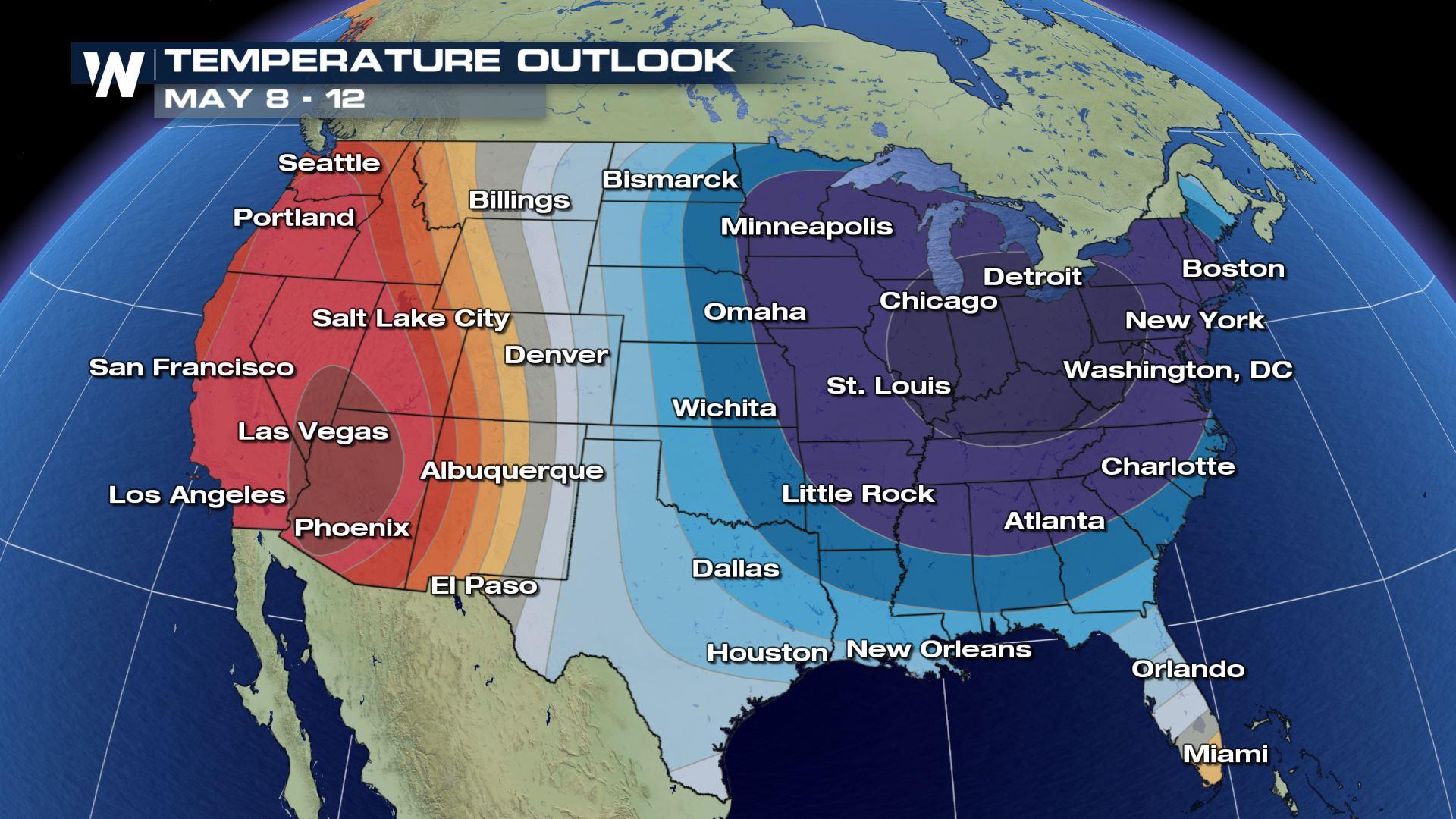
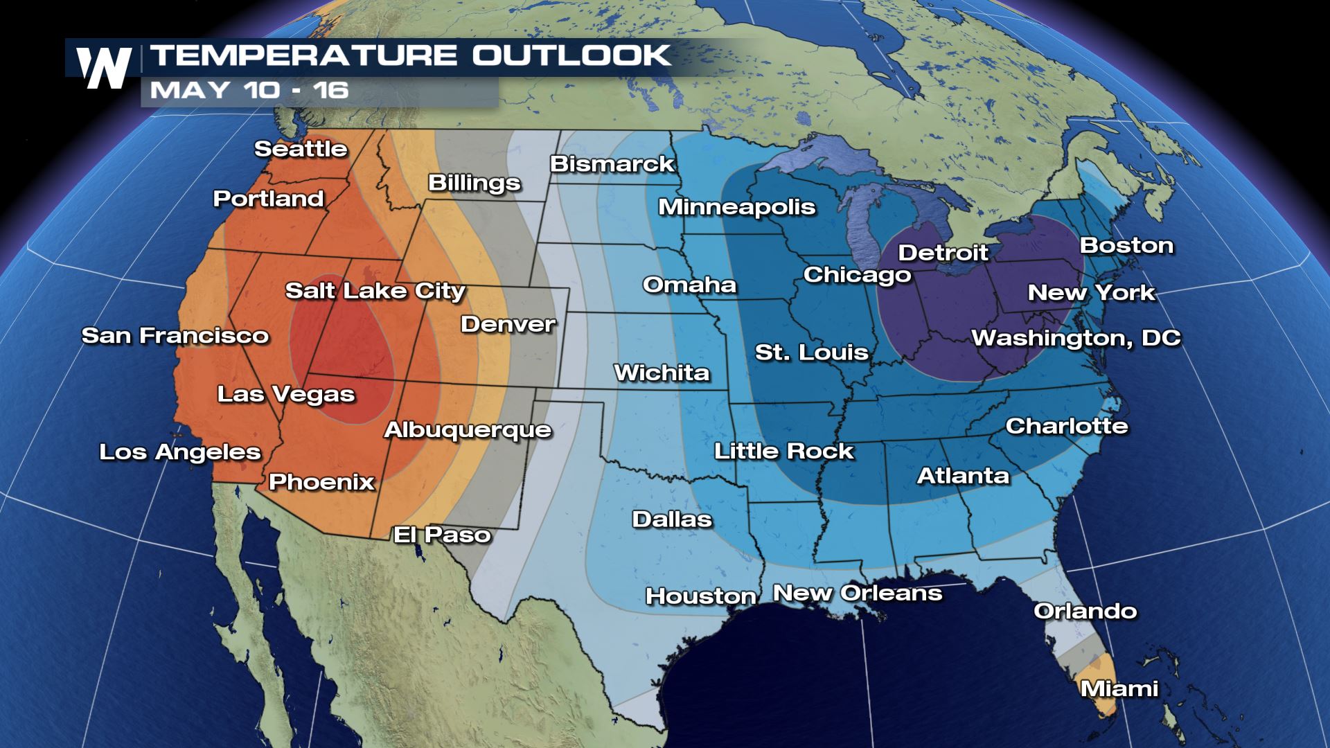
Another blast of significantly cooler-than-average weather will blast through the eastern half of the country next week, continuing a chilly start to the spring for much of the Great Lakes and Northeast. This could lead to several frost and freeze chances into those areas and potentially even further south for next week, in addition to overall chilly mid-May weather conditions for many.
Temperatures could run 15-20 degrees (or more) below average in many cases, peaking on Sunday and Monday across the Great Lakes and Monday through Wednesday along the East Coast.
If you're hoping to have a (socially distant) Mother's Day outdoors across the eastern half of the country, you're probably going to want to bundle up.
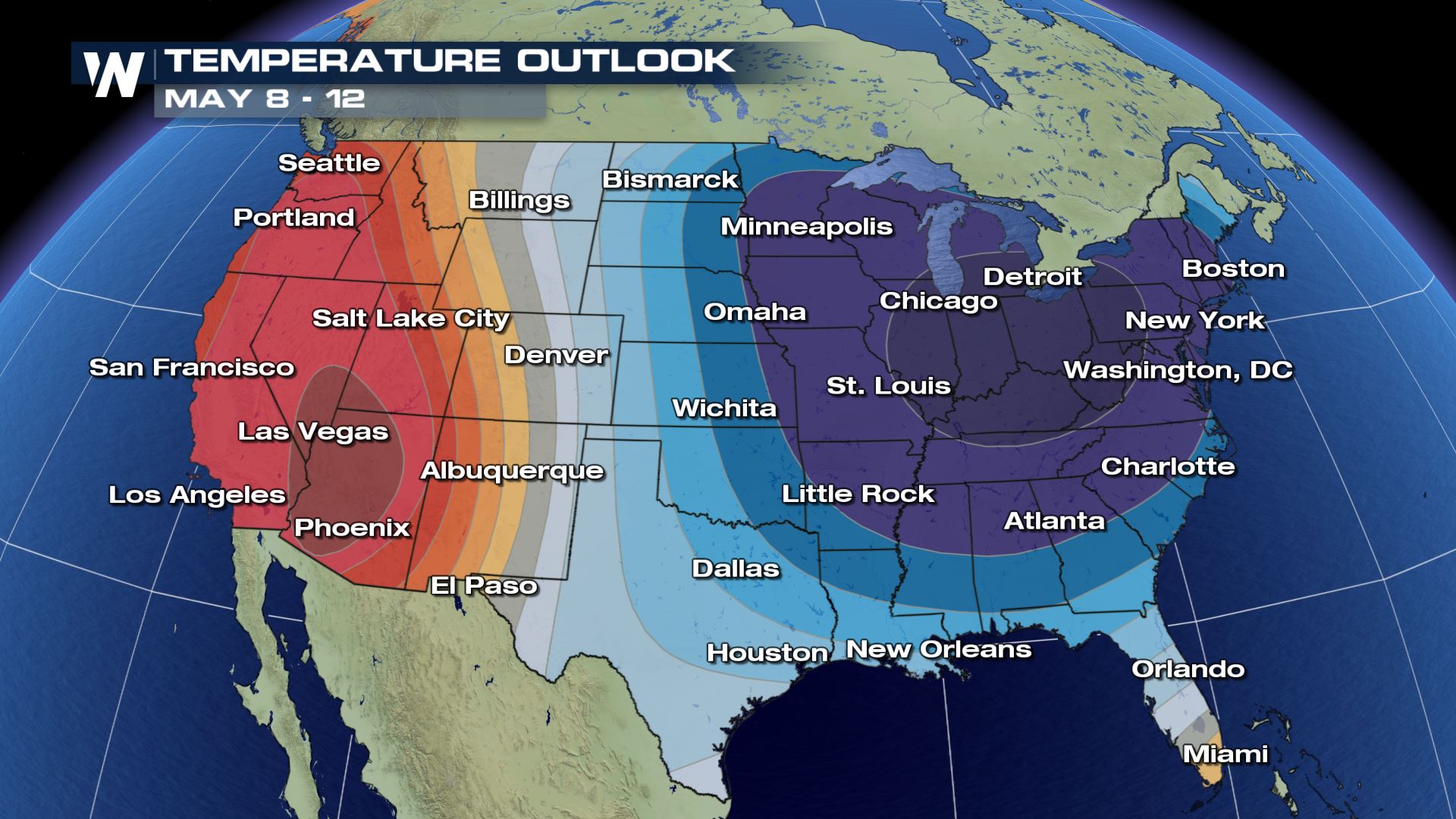 Similar to the last few cooler weather outbreaks across the East, a deep trough of low pressure will dive down from the north. That'll push the jet stream way further south than usual for early-to-mid May, dragging in air originating in central Canada. As you might imagine with air coming from areas like that, it'll be cold - certainly far colder than what you might expect for this time of the year.
That should keep the colder weather lasting well into parts of next week, as well. It's also coming on the heels of what was a chilly April for much of the northeastern quadrant of the lower 48.
If you're in agriculture or simply getting that quarantine garden in place across the East, you should keep an especially close watch on the forecast.
Similar to the last few cooler weather outbreaks across the East, a deep trough of low pressure will dive down from the north. That'll push the jet stream way further south than usual for early-to-mid May, dragging in air originating in central Canada. As you might imagine with air coming from areas like that, it'll be cold - certainly far colder than what you might expect for this time of the year.
That should keep the colder weather lasting well into parts of next week, as well. It's also coming on the heels of what was a chilly April for much of the northeastern quadrant of the lower 48.
If you're in agriculture or simply getting that quarantine garden in place across the East, you should keep an especially close watch on the forecast.
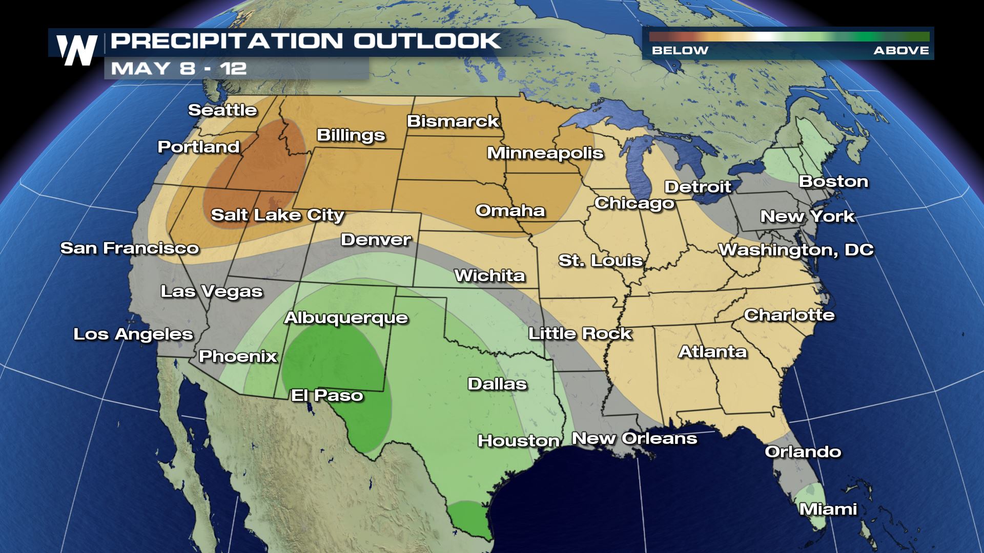
 As far as the precipitation outlook is concerned, it does appear to generally lean drier across the eastern and northern tiers of the country. High pressure should keep the Northwest, in particular, on the sunnier side.
 Now, for a little bit of good news: the cooler and generally drier weather could help suppress severe storm development, at least briefly. That's especially good for three key reasons.
One, severe weather, of course, is damaging and potentially deadly, so avoiding severe weather is good anytime of year.
But, two, that's especially welcome in May, which is traditionally the busiest month for severe weather all year round.
And, three, it's already been an unusually active start to the severe weather season. A break at this point is perhaps especially welcomed.
But of course, it comes with the caveat that colder weather means more jackets and potential frosts and freezes pretty late into the spring season.
Stay with WeatherNation for the latest on this potential surge of chilly weather next week.
Now, for a little bit of good news: the cooler and generally drier weather could help suppress severe storm development, at least briefly. That's especially good for three key reasons.
One, severe weather, of course, is damaging and potentially deadly, so avoiding severe weather is good anytime of year.
But, two, that's especially welcome in May, which is traditionally the busiest month for severe weather all year round.
And, three, it's already been an unusually active start to the severe weather season. A break at this point is perhaps especially welcomed.
But of course, it comes with the caveat that colder weather means more jackets and potential frosts and freezes pretty late into the spring season.
Stay with WeatherNation for the latest on this potential surge of chilly weather next week.
Similar to the last few cooler weather outbreaks across the East, a deep trough of low pressure will dive down from the north. That'll push the jet stream way further south than usual for early-to-mid May, dragging in air originating in central Canada. As you might imagine with air coming from areas like that, it'll be cold - certainly far colder than what you might expect for this time of the year.
That should keep the colder weather lasting well into parts of next week, as well. It's also coming on the heels of what was a chilly April for much of the northeastern quadrant of the lower 48.
If you're in agriculture or simply getting that quarantine garden in place across the East, you should keep an especially close watch on the forecast.
As far as the precipitation outlook is concerned, it does appear to generally lean drier across the eastern and northern tiers of the country. High pressure should keep the Northwest, in particular, on the sunnier side.
Now, for a little bit of good news: the cooler and generally drier weather could help suppress severe storm development, at least briefly. That's especially good for three key reasons.
One, severe weather, of course, is damaging and potentially deadly, so avoiding severe weather is good anytime of year.
But, two, that's especially welcome in May, which is traditionally the busiest month for severe weather all year round.
And, three, it's already been an unusually active start to the severe weather season. A break at this point is perhaps especially welcomed.
But of course, it comes with the caveat that colder weather means more jackets and potential frosts and freezes pretty late into the spring season.
Stay with WeatherNation for the latest on this potential surge of chilly weather next week.All Weather News
More

More Storms for the East Through Monday
A low-pressure system that moved through the
3 Aug 2026 12:20 PM


After Reaching Category 5, Genevieve Weakens in the Pacific
PacificGenevieve formed last Friday south of
3 Aug 2026 12:30 AM

Flooding, Severe Storms Target the Midwest Again
After an active week of storms across the nor
1 Aug 2026 1:40 AM

Flooding Risk Increases as Heavy Rain Targets the Tri-State Area
Tuesday, heavy rainfall moved across the Nort
30 Jul 2026 12:25 AM