Not Just Weather Satellites: GOES Aid Search and Rescue Capabilities

Special Stories
8 Mar 2018 8:43 AM
[NASA develops technologies that aid first responders in search and rescue efforts. Credit: U.S. Coast Guard photo by PAC Tom Sperduto]
From NASA
The National Oceanic and Atmospheric Administration’s (NOAA’s) Geostationary Operational Environmental Satellite (GOES) constellation monitors Earth’s environment, helping meteorologists observe and predict the weather. GOES observations have tracked thunderstorms, tornadoes, hurricanes and flash floods. They’ve even proven useful in monitoring dust storms, forest fires and volcanic activity.
The recently launched GOES-S (planned to replace the current GOES-West later this year) and other GOES series satellites carry a payload supported by NASA’s Search and Rescue (SAR) office, which researches and develops technologies to help first responders locate people in distress worldwide, whether from a plane crash, a boating accident or other emergencies.
https://www.youtube.com/watch?v=88xG6CuuY9c
Over its history, the SAR office at NASA’s Goddard Space Flight Center in Greenbelt, Maryland, has developed emergency beacons for personal, nautical and aeronautical use, along with ground station receivers that detect beacon activation. Space segment SAR instruments fly on many spacecraft in various orbits around the Earth. The GOES SAR transponders are geostationary, meaning that they appear “fixed” relative to a user on the surface due to their location over the equator and orbital period of 24 hours.
“The SAR space segment isn’t just one instrument in one orbit,” said Tony Foster, SAR’s deputy mission manager. “Rather it’s a series of instruments aboard diverse satellites in various orbits, each working together to provide first responders with highly accurate locations.”
The GOES search and rescue transponders, unlike SAR instruments in other orbits, are only able to detect the beacon signals, not help to determine location. This detection rapidly alerts the global SAR network, Cospas-Sarsat, of a distress beacon’s activation. This gives the system valuable time to prepare before the signal’s origin can be determined by SAR instruments on low-Earth-orbiting satellites.
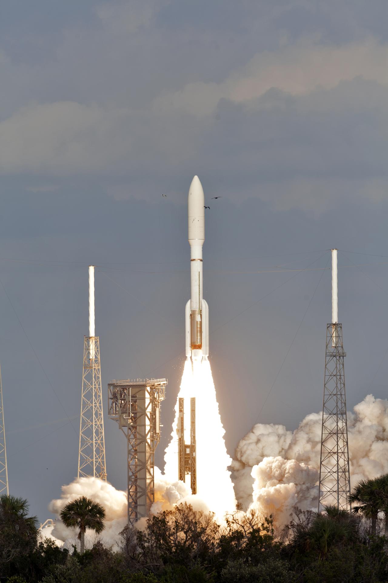 [GOES-S, carrying a search and rescue instrument, launched from Cape Canaveral, Florida, on March 1, 2018. Credits: NASA/Bill White]
Additionally, beacons with integrated GPS technology can send their location data through GOES to the SAR network. The network can then alert local first responders to the location of the emergency without the aid of the low-Earth-orbiting constellation of search and rescue instruments.
NASA’s SAR team provides on-orbit testing, support and maintenance of the search and rescue instrument on GOES. The GOES satellites and SAR instruments are funded by NOAA.
“We are proud to support the Cospas-Sarsat program by hosting a search and rescue transponder aboard our satellites,” said Tim Walsh, GOES-R series program acting system program director. “SAR is one of the many NOAA-NASA collaborations that translate into life-saving technology.”
https://www.facebook.com/WeatherNation/videos/10156296250339874/
In the future, first responders will rely on a new constellation of instruments on GPS and other Global Navigation Satellite Systems currently in medium-Earth orbit, an orbit that views larger swathes of the Earth than low-Earth orbit due to higher altitudes. These new instruments will enable the SAR network to locate a distress signal more quickly than the current system and calculate their position with accuracy an order of magnitude better, from one kilometer (0.6 miles) to approximately 100 meters (328 feet).
In the meantime, the SAR transponders aboard GOES cover the time between the activation of a distress signal and detection by SAR instruments in low-Earth orbit.
“NASA’s SAR office dedicates itself to speed and accuracy,” said Lisa Mazzuca, SAR mission manager. “The instruments and technologies we develop endeavor to alert first responders to a beacon’s activation as soon as possible. The GOES search and rescue transponders are crucial to this goal, providing near-instantaneous detection in the fields of view of the Earth.”
NASA’s SAR office is a project of Goddard’s Exploration and Space Communicationsprojects division. Programmatic oversight is provided by NASA’s Space Communications and Navigation program office at NASA Headquarters in Washington. GOES-S was successfully launched on March 1, 2018, aboard an Atlas V launch vehicle from Cape Canaveral, Florida.
Edited for WeatherNation by Meteorologist Mace Michaels
[GOES-S, carrying a search and rescue instrument, launched from Cape Canaveral, Florida, on March 1, 2018. Credits: NASA/Bill White]
Additionally, beacons with integrated GPS technology can send their location data through GOES to the SAR network. The network can then alert local first responders to the location of the emergency without the aid of the low-Earth-orbiting constellation of search and rescue instruments.
NASA’s SAR team provides on-orbit testing, support and maintenance of the search and rescue instrument on GOES. The GOES satellites and SAR instruments are funded by NOAA.
“We are proud to support the Cospas-Sarsat program by hosting a search and rescue transponder aboard our satellites,” said Tim Walsh, GOES-R series program acting system program director. “SAR is one of the many NOAA-NASA collaborations that translate into life-saving technology.”
https://www.facebook.com/WeatherNation/videos/10156296250339874/
In the future, first responders will rely on a new constellation of instruments on GPS and other Global Navigation Satellite Systems currently in medium-Earth orbit, an orbit that views larger swathes of the Earth than low-Earth orbit due to higher altitudes. These new instruments will enable the SAR network to locate a distress signal more quickly than the current system and calculate their position with accuracy an order of magnitude better, from one kilometer (0.6 miles) to approximately 100 meters (328 feet).
In the meantime, the SAR transponders aboard GOES cover the time between the activation of a distress signal and detection by SAR instruments in low-Earth orbit.
“NASA’s SAR office dedicates itself to speed and accuracy,” said Lisa Mazzuca, SAR mission manager. “The instruments and technologies we develop endeavor to alert first responders to a beacon’s activation as soon as possible. The GOES search and rescue transponders are crucial to this goal, providing near-instantaneous detection in the fields of view of the Earth.”
NASA’s SAR office is a project of Goddard’s Exploration and Space Communicationsprojects division. Programmatic oversight is provided by NASA’s Space Communications and Navigation program office at NASA Headquarters in Washington. GOES-S was successfully launched on March 1, 2018, aboard an Atlas V launch vehicle from Cape Canaveral, Florida.
Edited for WeatherNation by Meteorologist Mace MichaelsAll Weather News
More
Tropics: Fausto Heads towards Hawaii; Genevieve a Major Hurricane
PacificTropical Depression Fausto continues t
29 Jul 2026 10:15 AM

Flooding Risk Increases as Heavy Rain Targets the Tri-State Area
New England - Along with the threat of severe
29 Jul 2026 10:10 AM


Southeast Flood Risk Lingers Near Stalled Front
A stalled boundary over the Southeast will ke
25 Jul 2026 10:55 AM

Another Round of Storms Targets the Northeast
Tuesday brought severe weather again across p
23 Jul 2026 1:15 AM

Another Round of Severe Weather for the Upper Midwest and Great Lakes
The upper-level low train continues to keep t
21 Jul 2026 1:45 AM