One Year Ago: The Midwest Derecho
Introduction
The NOAA/NWS Storm Prediction Center issued numerous outlooks and watches throughout the day to provide advance notice of potential severe weather conditions. After storms formed, ten different NOAA National Weather Service Weather Forecast Offices issued Severe Thunderstorm Warnings to communicate the imminent threat of severe weather as storms traversed the Midwest. Offices also provided proactive weather briefings to city and county emergency managers which led to a significant amount of closures, evacuations, and event cancellations, including timely evacuations of several outdoor COVID-19 testing sites.
Weather support to the aviation community resulted in decisions that improved efficiency of the National Airspace System and led to a proactive ground stop ahead of severe storms impacting Chicago’s O’Hare and Midway International Airports. Partnerships forged between the NWS, city and county emergency management officials, and the broadcast media helped save lives during this extreme weather event.
Sunrise
 [Midwest surface weather map for 7:00 AM August 10, 2020, based upon an analysis by the NOAA/NWS Weather Prediction Center]
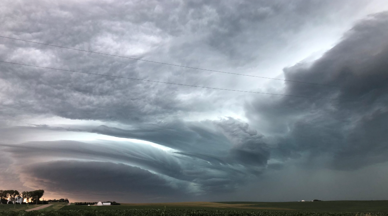
The morning of August 10, 2020, began with temperatures in the 70s and dew points in the low 70s across the upper Midwest. Winds were generally out of the southwest to south. Above the surface, winds changed direction to westerly, and speeds increased, leading to increased wind shear. A small area of thunderstorms was ongoing in South Dakota and began progressing east-southeastward. As the thunderstorms became more organized over eastern South Dakota and northeast Nebraska, the National Weather Service recognized an increasing threat for widespread severe weather.
Temperatures warmed into the 80s by late morning from eastern Iowa into Indiana, contributing to a significant increase in instability. The area of thunderstorms increased in organization and intensity as it moved into Iowa.
8AM: Early Morning
During the overnight hours, scattered strong thunderstorms first developed across south-central South Dakota. These storms were generally "elevated," feeding off of warm air above the ground while air near the ground was cooler due to nighttime cooling. Elevated storms can produce strong winds, but they often don't reach ground level.
 [Large hail observed in Gregory, South Dakota. Photo Credit: Kerri Fenenga via NOAA.]
Isolated large hail (up to 1-2 inches in diameter) and a small swath of damaging wind gusts (60 to 70 mph) were reported. The storms became better organized as they moved east, approaching Sioux City, Iowa, around 8AM.
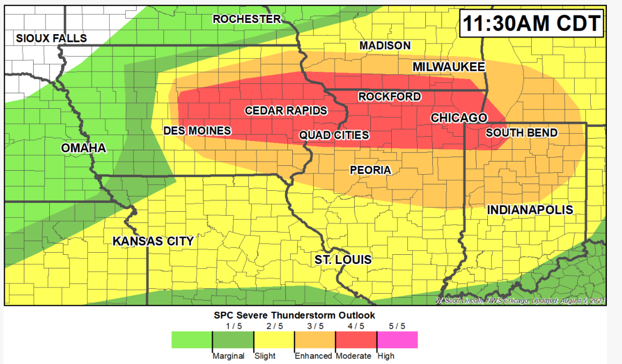
The Storm Prediction Center (SPC) recognized the increasing threat for widespread severe weather. SPC forecasters quickly introduced an Enhanced Risk of severe weather over portions of eastern Iowa and northern Illinois with a special 8 AM update, which was sent to provide more advanced notice.
[Large hail observed in Gregory, South Dakota. Photo Credit: Kerri Fenenga via NOAA.]
Isolated large hail (up to 1-2 inches in diameter) and a small swath of damaging wind gusts (60 to 70 mph) were reported. The storms became better organized as they moved east, approaching Sioux City, Iowa, around 8AM.
The Storm Prediction Center (SPC) recognized the increasing threat for widespread severe weather. SPC forecasters quickly introduced an Enhanced Risk of severe weather over portions of eastern Iowa and northern Illinois with a special 8 AM update, which was sent to provide more advanced notice.
10AM: Morning
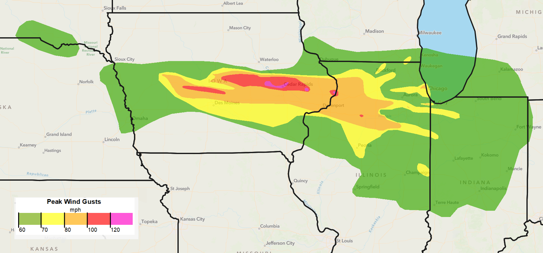
From 8AM to 10AM, storms crossed the Big Sioux and Missouri Rivers and then progressed into western Iowa. Damaging wind gusts (60 to 70 mph) again became common. After sunrise, the warming of the ground allowed for more wind gusts to reach the ground level. As the main area of storms neared Storm Lake, Denison, and Atlantic in west central Iowa around 10AM, wind speeds began to increase significantly.
South of the main area of storms, some of the strong wind gusts became trapped underneath an inversion layer (warm air just above the ground), which helped them to move rapidly to the south and southeast. Numerous instances of tree and powerline damage were reported in far eastern Nebraska and western Iowa, more than 50 miles away from the main area of storms and in areas with little or no rainfall.
 [The leading edge of storms moving into the Le Mars, Iowa, area. Photo Credit: Dave Nicks]
12PM: Midday
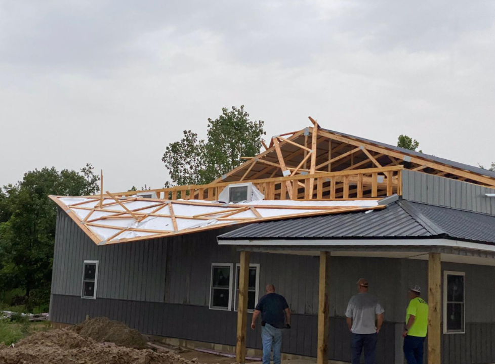
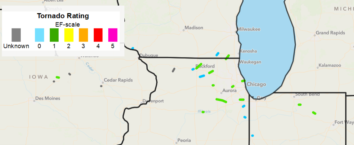
From 10AM to 12PM, the complex of storms moved into central Iowa and wind gusts continued to increase. A corridor of significant straight-line winds (80 to 100 mph) began to the east of Denison, and continued toward Ames and Des Moines. Wind gusts were severe enough to not only cause widespread damage to trees and powerlines, but to also damage structures and crops. The most extreme winds (100 to 120 mph) during this time period occurred in Iowa within two swaths; the first began near Jefferson, and moved east toward the Madrid and Huxley areas. Numerous instances of damage to rooftops, walls, and windows were reported. A second area of extreme winds developed just to the northeast of Ames and reached the Marshalltown area around 12PM. Three tornadoes also occurred near Marshalltown, which, due to the more severe and more extensive damage from straight-line wind gusts, had to be determined from satellite and drone imagery. The strongest tornado was rated EF-1. Although Des Moines, was just to the south of the strongest wind gusts, numerous instances of damage to trees, power lines, and structures were reported due to 70 to 80 mph wind gusts.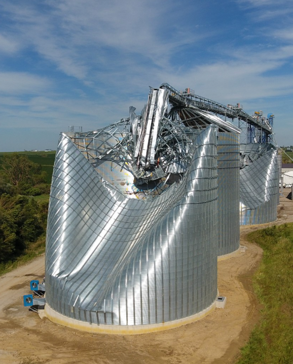 [Damage to grain bins in Tama County. Image from NOAA by Kip Ladage]
During this time period, corn and soybean crops were flattened over such a large area that the corridor of storm damage was visible on satellite imagery. Damage to power lines was also so extensive that power outages were visible from space at night.

2PM: Early Afternoon
Between 12PM and 2PM, storms continued to produce widespread damaging wind gusts as they moved east from central Iowa into eastern Iowa. The area of extreme winds near Marshalltown, Iowa maintained strength during the early afternoon and strengthened as it moved east.
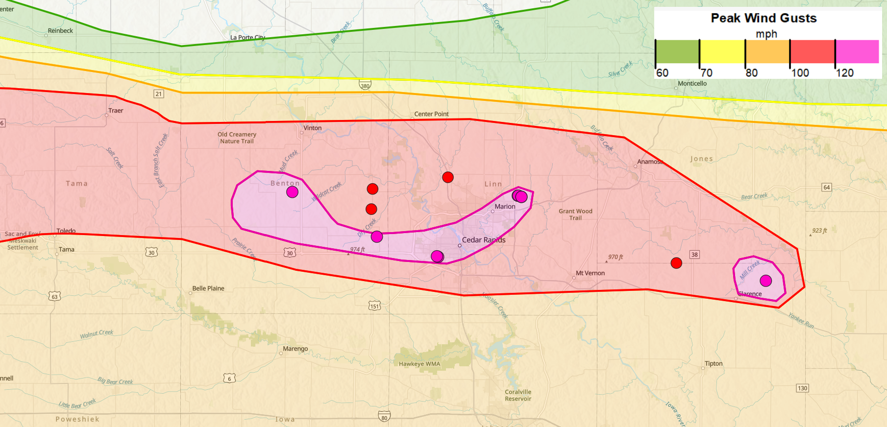
A corridor of particularly extreme winds - peak wind gusts reaching 120 mph or greater - began in Benton County, Iowa, and then moved east into Cedar Rapids, Iowa. Near Wiley Boulevard and Wilson Avenue, winds estimated at about 140 mph removed the roof and multiple exterior walls of an apartment building.
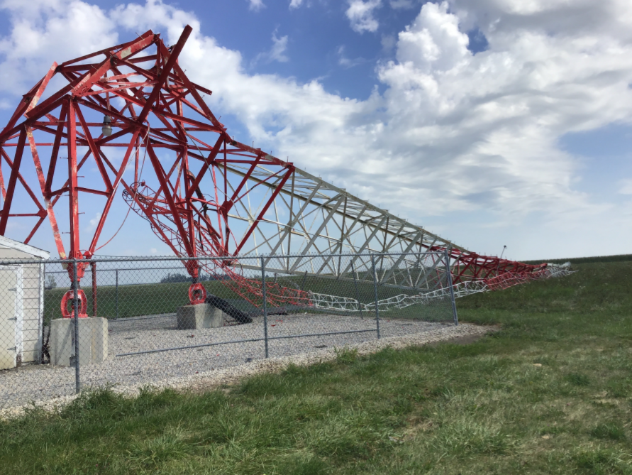 [Damage to the radio transmission tower for WMT near Marion. Photo credit: NWS Storm Survey]
Nearby, multiple other residences sustained damage to rooftops and some walls, and a small strip mall was significantly damaged.
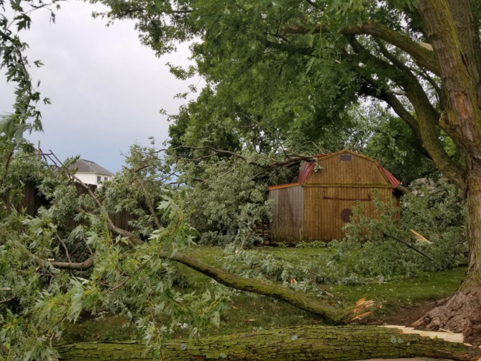
The corridor of extreme wind gusts reaching 120 mph or greater continued to the east-northeast across downtown Cedar Rapids into northeast portions of the city. These extreme wind gusts - plus the unusually long duration of damaging wind gusts - continued to damage structures and knocked down a large portion of trees across the city.
A brief tornado occurred near the Eastern Iowa Airport south of Cedar Rapids, but did not cause any damage that could produce an EF rating.
[Damage to the radio transmission tower for WMT near Marion. Photo credit: NWS Storm Survey]
Nearby, multiple other residences sustained damage to rooftops and some walls, and a small strip mall was significantly damaged.
The corridor of extreme wind gusts reaching 120 mph or greater continued to the east-northeast across downtown Cedar Rapids into northeast portions of the city. These extreme wind gusts - plus the unusually long duration of damaging wind gusts - continued to damage structures and knocked down a large portion of trees across the city.
A brief tornado occurred near the Eastern Iowa Airport south of Cedar Rapids, but did not cause any damage that could produce an EF rating.
5PM: Mid-to-Late Afternoon
Between 2PM and 5PM, storms continued to produce widespread damaging wind gusts as they crossed the Mississippi River into northern Illinois, but the peak wind speeds began to diminish slightly. By the time the line of storms reached Lake Michigan and northern Indiana, the once continuous corridor of extreme winds had evolved into lower-end damaging winds (60 to 70 mph) across a larger area with embedded narrow corridors of more significant wind gusts (70 to 80 mph). The environment also became more favorable for the formation of weak tornadoes.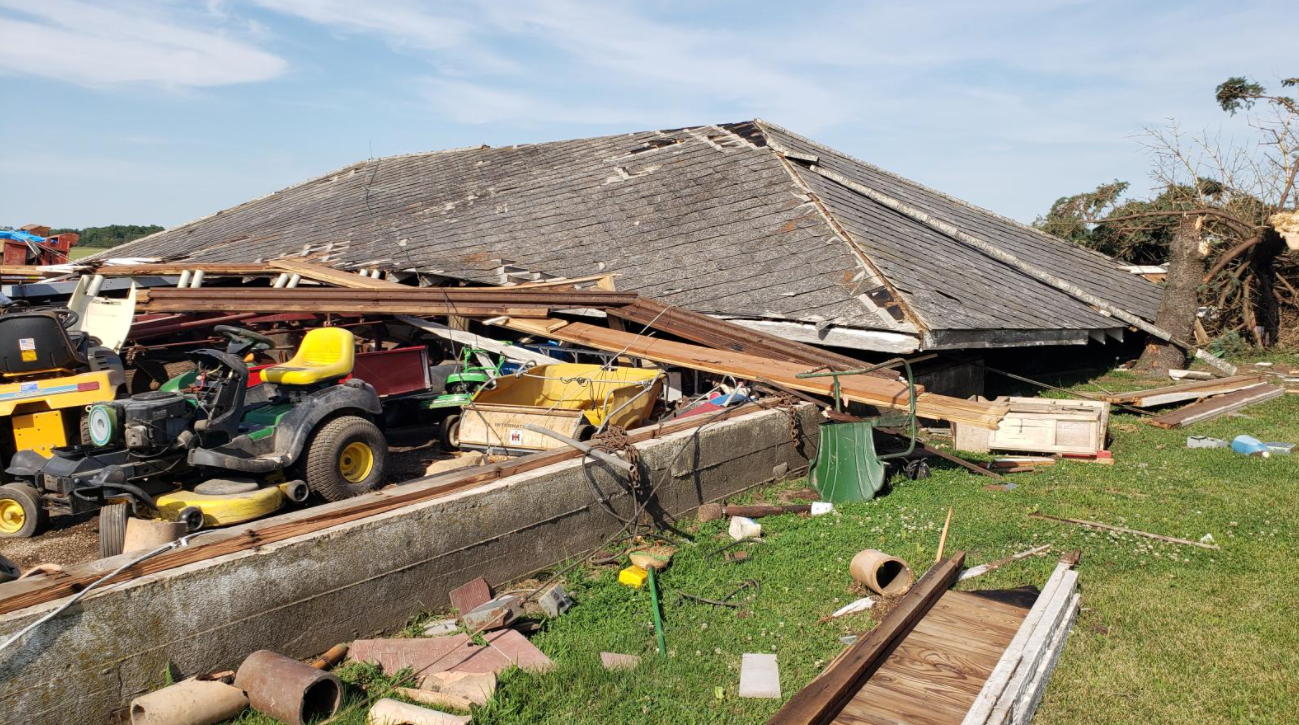
A storm that formed ahead of the main line of thunderstorms impacted the Rockford area just before 3PM and produced two tornadoes, rated EF-0 and EF-1. Around 3PM, numerous additional brief tornadoes formed along the line of storms impacting areas in Illinois near Kirkland, Marengo, Elburn, and Ottawa. In Ottawa, a tornado rated EF-1 damaged trees, power lines, and roofs. Shortly after 3PM, another tornado touched down near Yorkville and tracked for almost 15 miles toward Plainfield causing EF-1 damage. As it moved across north central Illinois, the line of storms caused four injuries in the vicinity of La Salle, all due to straight-line winds.
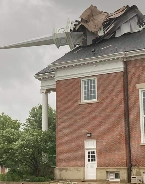 [Tornado damage to a church in Wheaton. Image by Carrie Vicek-Jodelka via NOAA]
Additional brief tornadoes occurred over this time period near Grant Park, Illinois, and Kentland, Indiana.
8PM: Evening
From 5PM to 8PM, the line of storms moved from western Indiana to western Ohio. Wind gusts continued to diminish as the storms moved east, but continued to be strong enough for some damage (60 to 70 mph). A couple additional tornadoes were also reported in northern Indiana.
 [Structure damage near Roanoke, Indiana. From Huntington County Emergency Management Agency via NOAA]
Summary
The storm system also produced 26 weak tornadoes, although damage from the tornadoes was similar in magnitude to that caused by straight-line winds.
 Edited for WeatherNation by Mace Michaels


