Oscar Transitions: Decoding Subtropical vs. Tropical Storms
Special Stories
27 Oct 2018 3:47 PM
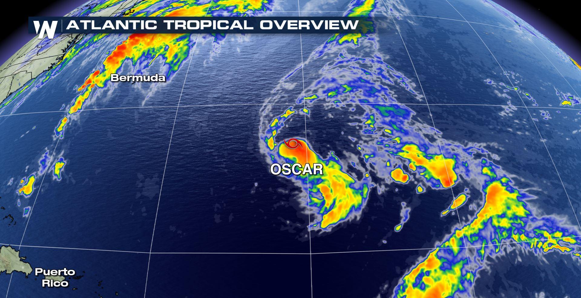
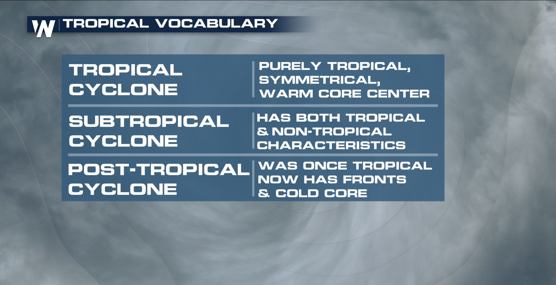
The fifteenth named storm of the 2018 Atlantic hurricane season continues to churn over the open waters of the Atlantic. However, as Oscar continues to change in intensity, it is also changing how and where it gets its power. On Friday October 26, Oscar was given a name as a Subtropical storm. A subtropical storm has characteristics of both tropical and extra tropical systems. It's typically and upper-level, cold low that extends to the surface. They don't have fronts, like a mid-latitude cyclone, and they are generally less symmetric than their tropical counterparts. Maximum winds stretch about 100 miles from the center. Regardless, the "storm" classification means its wind speeds are at least 39 mph.
 While Oscar initially qualified as subtropical, it began to change. The National Hurricane Center highlighted this transition in its latest discussion:
https://twitter.com/NHC_Atlantic/status/1056282902156267522
"Oscar is still located beneath an upper-level low, however it its
convective structure is now more reminiscent of a tropical cyclone.
Deep convection is primarily occurring in a small burst just south
of the center of Oscar, however this convective activity appears to
be displaced by light northerly shear associated with the upper-low.
Earlier AMSU sounding data indicated that the cyclone has developed
a weak but vertically deep warm core which also indicates that Oscar
is nearly a tropical cyclone, if it isn't one already. Oscar is
moving quickly westward away from the upper-low, and will likely
become a tropical storm later tonight if its current structural
trends continue."
A tropical cyclone is also non-frontal. The difference is the warm core. It gains energy from the warm surface temperatures of the ocean waters.
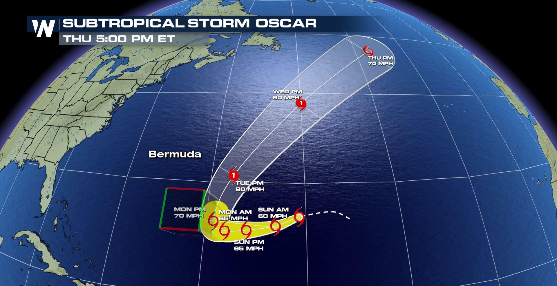
Here's a look at the latest forecast as Oscar works through the Atlantic:
While Oscar initially qualified as subtropical, it began to change. The National Hurricane Center highlighted this transition in its latest discussion:
https://twitter.com/NHC_Atlantic/status/1056282902156267522
"Oscar is still located beneath an upper-level low, however it its
convective structure is now more reminiscent of a tropical cyclone.
Deep convection is primarily occurring in a small burst just south
of the center of Oscar, however this convective activity appears to
be displaced by light northerly shear associated with the upper-low.
Earlier AMSU sounding data indicated that the cyclone has developed
a weak but vertically deep warm core which also indicates that Oscar
is nearly a tropical cyclone, if it isn't one already. Oscar is
moving quickly westward away from the upper-low, and will likely
become a tropical storm later tonight if its current structural
trends continue."
A tropical cyclone is also non-frontal. The difference is the warm core. It gains energy from the warm surface temperatures of the ocean waters.
Here's a look at the latest forecast as Oscar works through the Atlantic:
All Weather News
More


More Storms for the East Sunday and Monday
A low-pressure system crashing through the Mi
2 Aug 2026 2:20 AM

After Reaching Category 5, Genevieve Weakens in the Pacific
PacificGenevieve formed on last Friday south
2 Aug 2026 1:30 AM

Flooding, Severe Storms Target the Midwest Again
After an active week of storms across the nor
1 Aug 2026 1:40 AM

Flooding Risk Increases as Heavy Rain Targets the Tri-State Area
Tuesday, heavy rainfall moved across the Nort
30 Jul 2026 12:25 AM

Severe Weather: Energy From the Midwest Now in the Southeast
UPPER MIDWEST - Through Monday, dangerous tor
29 Jul 2026 10:30 PM