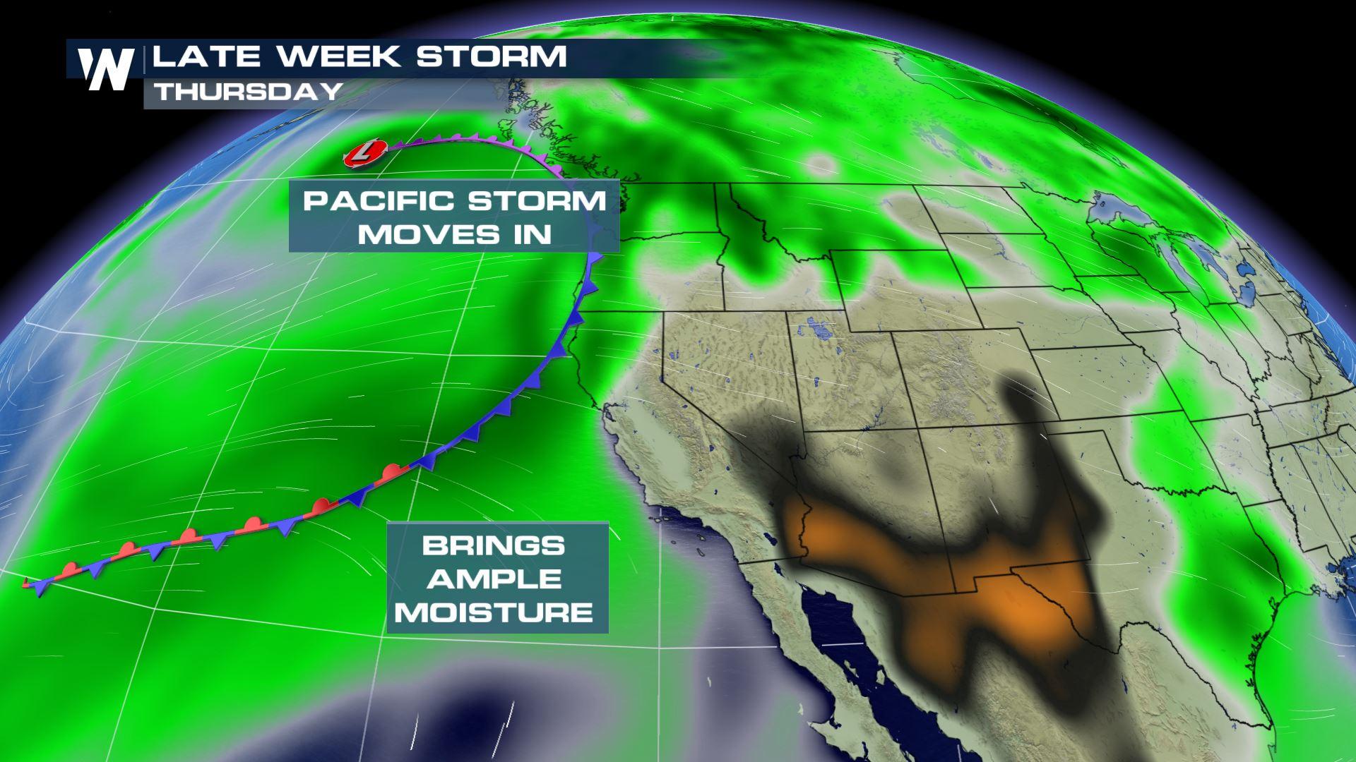
Pacific Moisture Returns to the West
Special Stories
4 Apr 2018 4:32 PM
Several rounds of rain and snow will begin to impact the western United States late this week thanks to the "Pineapple Express."
https://twitter.com/NWSBayArea/status/981613453172527110
The Pineapple Express---an atmospheric river of moisture originating near Hawaii---is often necessary to keep the West Coast drought-free. However, it can bring hazardous weather in the form of flooding and mudslides. But what is an atmospheric river?
https://twitter.com/NWSBayArea/status/981190965036830720
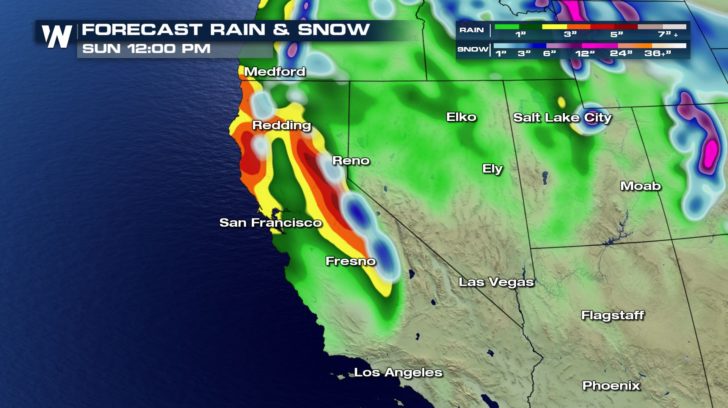
With a milder air mass in place, mountain locations like the Sierra Nevada will contend with melting snow and falling rain. The risk of flooding will increase.
https://twitter.com/NWSSacramento/status/981581665670610944
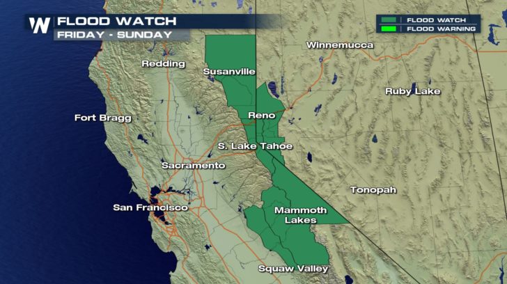
A Flood Watch is posted for the mountains and foothills along the California - Nevada border. Rainfall may exceed 6 inches in parts of the Sierra Nevada by Sunday.
 River flooding is a concern. But what is the chance for debris flows or mudslides, especially in burn scar areas? WeatherNation spoke with the National Weather Service Bay Area office in Monterey, California. Meteorologist Scott Rowe explains.
https://twitter.com/WeatherNation/status/981660219758411776
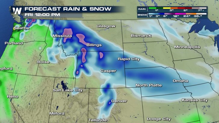
As you might expect with a Pacific system, the Northwest will also join in on the rain and subsequently, the threat for flooding. Snow will be more of a concern with colder temperatures in place across the Northern Rockies and High Plains.
River flooding is a concern. But what is the chance for debris flows or mudslides, especially in burn scar areas? WeatherNation spoke with the National Weather Service Bay Area office in Monterey, California. Meteorologist Scott Rowe explains.
https://twitter.com/WeatherNation/status/981660219758411776
As you might expect with a Pacific system, the Northwest will also join in on the rain and subsequently, the threat for flooding. Snow will be more of a concern with colder temperatures in place across the Northern Rockies and High Plains.
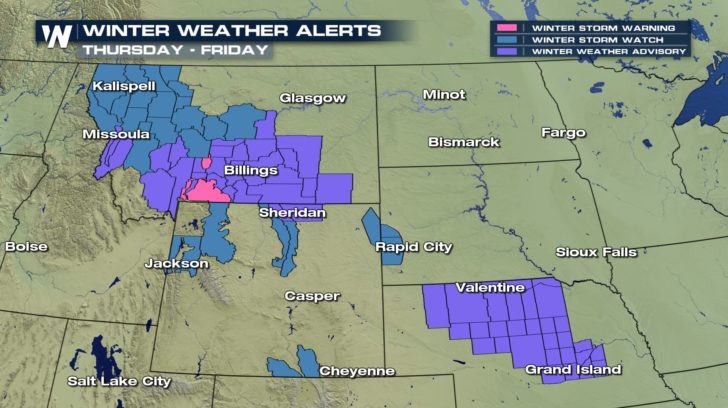 Snow totals may approach 6 inches in the valleys, plains, and lower elevation locations. The mountains---in Wyoming, in particular---may see snow accumulations near 12 inches.
 Be sure to follow WeatherNation on Facebook and Twitter for the latest West Coast forecast and other top weather stories.
-Meteorologist Joe Astolfi
Be sure to follow WeatherNation on Facebook and Twitter for the latest West Coast forecast and other top weather stories.
-Meteorologist Joe Astolfi
River flooding is a concern. But what is the chance for debris flows or mudslides, especially in burn scar areas? WeatherNation spoke with the National Weather Service Bay Area office in Monterey, California. Meteorologist Scott Rowe explains.
https://twitter.com/WeatherNation/status/981660219758411776
As you might expect with a Pacific system, the Northwest will also join in on the rain and subsequently, the threat for flooding. Snow will be more of a concern with colder temperatures in place across the Northern Rockies and High Plains.
Snow totals may approach 6 inches in the valleys, plains, and lower elevation locations. The mountains---in Wyoming, in particular---may see snow accumulations near 12 inches.
Be sure to follow WeatherNation on Facebook and Twitter for the latest West Coast forecast and other top weather stories.
-Meteorologist Joe AstolfiAll Weather News
More
Fronts Continue To Spark Severe Weather Across the Plains
A cold front that brought record lows to the
18 Jul 2025 10:40 PM

Extreme Heat Impacts for the East Coast & South
Extreme heat continues to impact several area
18 Jul 2025 10:05 PM

Flooding Threat Remains Elevated in the East
A cold front pushing through the Eastern Seab
18 Jul 2025 9:10 PM

EF-2 Firenado from the Deer Creek Fire in Utah
A fire tornado was spotted near La Sal, Utah
18 Jul 2025 7:30 AM

Tropical System Brings Flood Risk to the Central Gulf
Time has run out for notable tropical develop
18 Jul 2025 3:05 AM

Heavy Rain, Flooding Threat Returns to Florida
Keep the rain boots handy in Florida - heavy
13 Jul 2025 12:50 PM

Severe Storm Risk Pushes into the Great Lakes, Ohio Valley
Friday was another busy day with severe weath
12 Jul 2025 8:00 PM