Recapping This Historic Nor'easter
Top Stories
18 Dec 2020 1:00 PM
The Northeast just got pummeled by one of the largest, and most disruptive December winter storms in a while.
 After an initial area of low pressure dropped snow in the southern Plains, the system went on to spawn a coastal storm along the Eastern Seaboard, intensifying into a powerful Nor’easter packing rain, wind, ice, and FEET of snow.
https://twitter.com/WeatherNation/status/1339057665406685184
Impacts began in the Carolinas and Virginias, where sleet and freezing rain led to numerous slick spots.
https://twitter.com/WeatherNation/status/1339209616786219009
Heavy rain soaked much of the immediate Mid-Atlantic coast, while a strong onshore flow led to power outages, coastal flooding, and beach erosion. Wind gusts reached up to 60 miles per hour along the Jersey Shore.
https://twitter.com/WeatherNation/status/1339314358900277249
As precipitation continued to move into bitter cold air heavy snow began farther north, including the I-95 corridor. Philadelphia was thumped by 6.6 inches of snow before a changeover to ice marking the largest winter storm there since 2018, and more snow than the city saw ALL of last winter.
https://twitter.com/NWS_MountHolly/status/1339570534909034496
They weren’t alone. Several other large Pennsylvania cities blew past last winter’s snow total with this storm, including Harrisburg, State College, and Allentown. It also became Williamsport’s largest snowstorm on record.
https://twitter.com/WeatherNation/status/1339359656746098693
New York City was next in line. Heavy snow turned the Big Apple into a winter wonderland. Six to twelve inches of snow blanketed the city, also more snow than was observed in all of last winter.
https://twitter.com/WeatherNation/status/1339374757112852480
As the Nor’easter continued to track northward, wind-driven snow eventually overspread southern and central New England, including the Boston area. Many areas got close to, or eclipsed a foot of snow.
https://twitter.com/WeatherNation/status/1339601251777048576
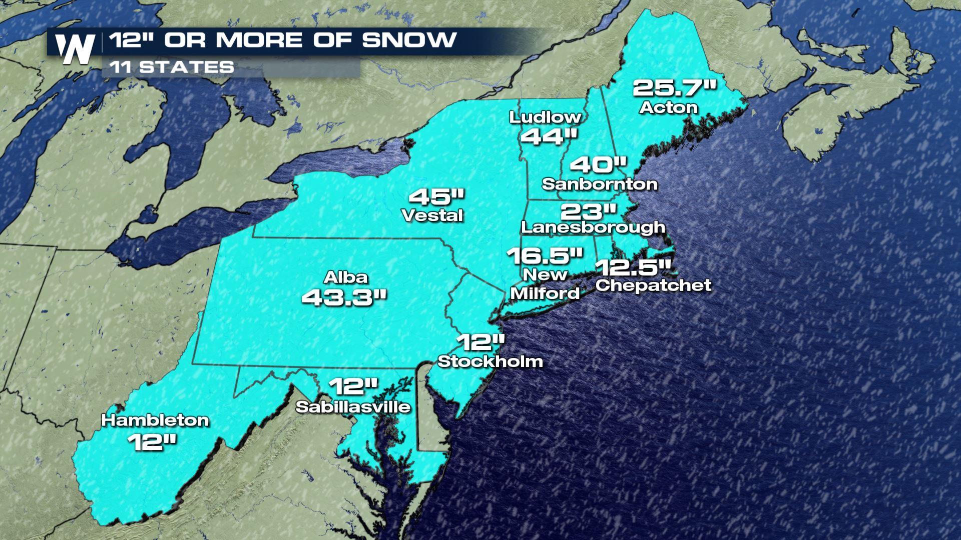
The biggest wallop of snow was concentrated where a persistent, intense snow band set up from northern Pennsylvania into upstate New York. Snow was falling at rates of 3 to 6 inches PER HOUR during the height of storm, leading to localized snowfall totals of up to 4 FEET!
https://twitter.com/NWSEastern/status/1339639102120058883
The Nor’easter left many roads temporarily impassible, and many towns with a grueling cleanup process.
After an initial area of low pressure dropped snow in the southern Plains, the system went on to spawn a coastal storm along the Eastern Seaboard, intensifying into a powerful Nor’easter packing rain, wind, ice, and FEET of snow.
https://twitter.com/WeatherNation/status/1339057665406685184
Impacts began in the Carolinas and Virginias, where sleet and freezing rain led to numerous slick spots.
https://twitter.com/WeatherNation/status/1339209616786219009
Heavy rain soaked much of the immediate Mid-Atlantic coast, while a strong onshore flow led to power outages, coastal flooding, and beach erosion. Wind gusts reached up to 60 miles per hour along the Jersey Shore.
https://twitter.com/WeatherNation/status/1339314358900277249
As precipitation continued to move into bitter cold air heavy snow began farther north, including the I-95 corridor. Philadelphia was thumped by 6.6 inches of snow before a changeover to ice marking the largest winter storm there since 2018, and more snow than the city saw ALL of last winter.
https://twitter.com/NWS_MountHolly/status/1339570534909034496
They weren’t alone. Several other large Pennsylvania cities blew past last winter’s snow total with this storm, including Harrisburg, State College, and Allentown. It also became Williamsport’s largest snowstorm on record.
https://twitter.com/WeatherNation/status/1339359656746098693
New York City was next in line. Heavy snow turned the Big Apple into a winter wonderland. Six to twelve inches of snow blanketed the city, also more snow than was observed in all of last winter.
https://twitter.com/WeatherNation/status/1339374757112852480
As the Nor’easter continued to track northward, wind-driven snow eventually overspread southern and central New England, including the Boston area. Many areas got close to, or eclipsed a foot of snow.
https://twitter.com/WeatherNation/status/1339601251777048576
The biggest wallop of snow was concentrated where a persistent, intense snow band set up from northern Pennsylvania into upstate New York. Snow was falling at rates of 3 to 6 inches PER HOUR during the height of storm, leading to localized snowfall totals of up to 4 FEET!
https://twitter.com/NWSEastern/status/1339639102120058883
The Nor’easter left many roads temporarily impassible, and many towns with a grueling cleanup process.All Weather News
More
Wildfire Outbreak in the Pacific Northwest
SPOKANE, WA - On Saturday, August 1st, the Ol
3 Aug 2026 1:55 AM

More Storms for the East Through Monday
A low-pressure system that moved through the
3 Aug 2026 1:50 AM


After Reaching Category 5, Genevieve Weakens in the Pacific
PacificGenevieve formed last Friday south of
3 Aug 2026 12:30 AM

Flooding, Severe Storms Target the Midwest Again
After an active week of storms across the nor
1 Aug 2026 1:40 AM

Flooding Risk Increases as Heavy Rain Targets the Tri-State Area
Tuesday, heavy rainfall moved across the Nort
30 Jul 2026 12:25 AM

Severe Weather: Energy From the Midwest Now in the Southeast
UPPER MIDWEST - Through Monday, dangerous tor
29 Jul 2026 10:30 PM