Researchers Study Lower Atmosphere to Answer Severe Weather Questions
Special Stories
15 Dec 2020 1:49 AM
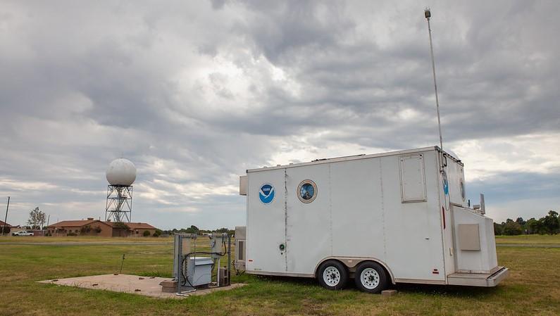
[The Collaborative Lower Atmospheric Mobile Profiling System, or CLAMPS, in Norman, Oklahoma. CLAMPS was deployed near a weather radar and weather station as part of an experiment to better understanding the depth of the boundary layer. (Photo by James Murnan/NOAA)]
[From NOAA NSSL by Emily Summars] While scientists have learned a lot about our planet, questions remain about the lowest part of the atmosphere where we live. Researchers at the NOAA National Severe Storms Laboratory are looking for answers. Utilizing a series of instruments located in a mobile research unit, researchers are analyzing data gathered by those tools to improve severe weather forecasts.
The lowest few 1,000 feet of the atmosphere, known as the planetary boundary layer, is where several elements mix — from pollution to moisture — and how those elements mix and change during the day impact events in the atmosphere.
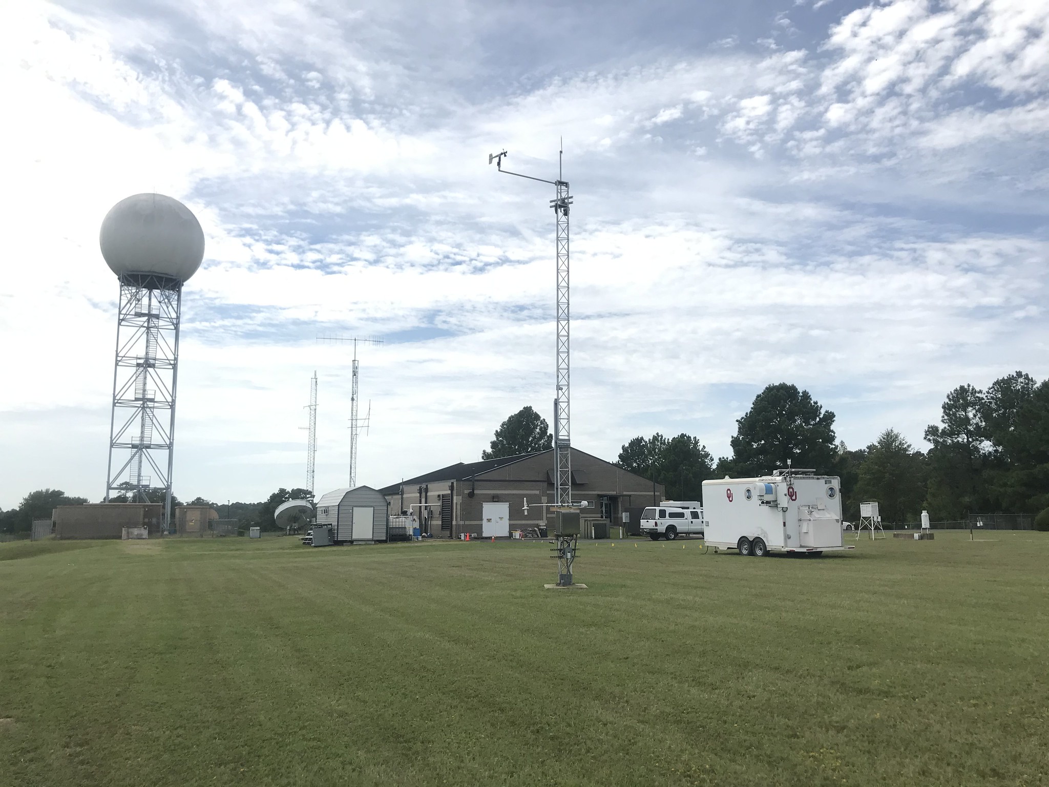 [The CLAMPS trailer in Shreveport, Louisiana at the NWS Forecast Office as part of an OU CIMMS and NOAA NSSL experiment. (Photo by Matthew Carney/OU)]
“Understanding the boundary layer can improve forecasts of severe weather, pollution, and several other things impacting the surface,” said Elizabeth Smith, NOAA National Severe Storms Laboratory researcher.
In an effort to improve understanding, weather researchers with the Cooperative Institute for Mesoscale Meteorological Studies at the University of Oklahoma and NOAA NSSL deployed two trailers decked out with a collection of weather instruments known as the Collaborative Lower Atmospheric Mobile Profiling System in fall 2020.
[The CLAMPS trailer in Shreveport, Louisiana at the NWS Forecast Office as part of an OU CIMMS and NOAA NSSL experiment. (Photo by Matthew Carney/OU)]
“Understanding the boundary layer can improve forecasts of severe weather, pollution, and several other things impacting the surface,” said Elizabeth Smith, NOAA National Severe Storms Laboratory researcher.
In an effort to improve understanding, weather researchers with the Cooperative Institute for Mesoscale Meteorological Studies at the University of Oklahoma and NOAA NSSL deployed two trailers decked out with a collection of weather instruments known as the Collaborative Lower Atmospheric Mobile Profiling System in fall 2020.
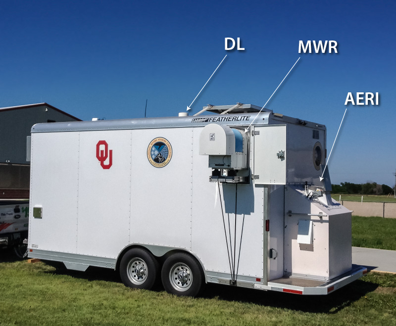 [The CLAMPS-1 trailer, showing the Doppler LIDAR (DL), Microwave Radiometer (MWR), and Atmospheric Emitted Radiance Interferometer (AERI), as it appeared at the start of the PECAN project in June 2015. From NOAA]
The CLAMPS platforms were deployed near a weather radar and a weather station in Oklahoma as well as the National Weather Service Forecast Office in Shreveport, Louisiana. The fast-updating, high-resolution data collected provides a more detailed view of the atmosphere and its processes for researchers to analyze.
In addition, the Shreveport NWS Office utilized CLAMPS to monitor both fog and fire weather forecasts during CLAMPS deployment in the area. That office also noted interesting and surprising boundary layer behavior when smoke from fires raging in the western part of the United States infiltrated into the area.
[The CLAMPS-1 trailer, showing the Doppler LIDAR (DL), Microwave Radiometer (MWR), and Atmospheric Emitted Radiance Interferometer (AERI), as it appeared at the start of the PECAN project in June 2015. From NOAA]
The CLAMPS platforms were deployed near a weather radar and a weather station in Oklahoma as well as the National Weather Service Forecast Office in Shreveport, Louisiana. The fast-updating, high-resolution data collected provides a more detailed view of the atmosphere and its processes for researchers to analyze.
In addition, the Shreveport NWS Office utilized CLAMPS to monitor both fog and fire weather forecasts during CLAMPS deployment in the area. That office also noted interesting and surprising boundary layer behavior when smoke from fires raging in the western part of the United States infiltrated into the area.
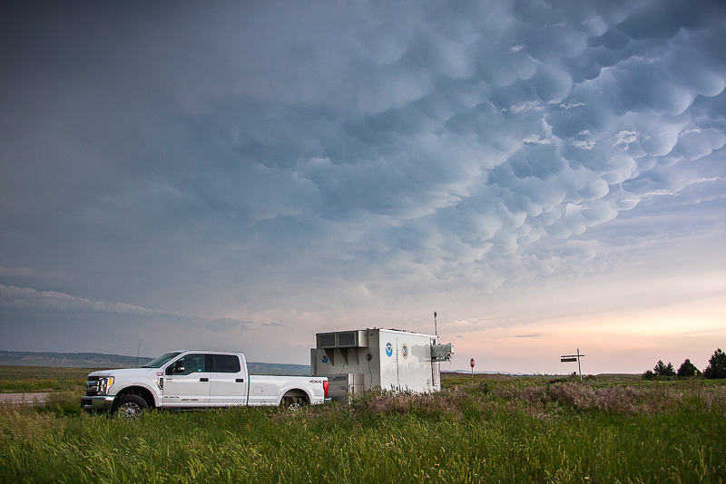 [The CLAMPS-2 trailer deployed in southeast Wyoming and southwest Nebraska. (Credit: Brandon Smith/OU CIMMS)]
NWS Shreveport Science and Operations Officer Brad Bryant said output from CLAMPS was particularly useful for refining fog and fire weather forecasts because both sets of parameters are closely tied to specifics of the boundary layer CLAMPS is tuned to monitor.
CIMMS Researcher and Project Lead Jacob Carlin said the CLAMPS platform collects information more frequently than weather balloons launched daily by NWS forecasters across the nation. Although both methods gather similar information about the atmosphere, weather balloons are typically launched twice a day while CLAMPS gather data every couple of minutes.
More data can result in a more accurate representation of atmospheric processes at any moment. Data from the CLAMPS systems is combined with data from the NEXRAD radar, further enhancing researchers’ view of the atmosphere and what is happening.
https://www.youtube.com/watch?v=nPG6kJ0nPKg&feature=emb_logo
This project is an extension of a recently published study that compared the twice-a-day balloon launch data with data from a nearby NEXRAD radar. Carlin’s team is going further, comparing CLAMPS minute data with a nearby NEXRAD radar and weather station.
“We want to understand how well this method performs with CLAMPS, because if it is able to reliably observe boundary layer height and development, then this method can improve forecasts and forecasting tools,” Carlin said.
With this new dataset, the researchers hope to learn more about how well NEXRAD radar can detect the boundary layer, expanding the capability of existing infrastructure at no additional cost.
[The CLAMPS-2 trailer deployed in southeast Wyoming and southwest Nebraska. (Credit: Brandon Smith/OU CIMMS)]
NWS Shreveport Science and Operations Officer Brad Bryant said output from CLAMPS was particularly useful for refining fog and fire weather forecasts because both sets of parameters are closely tied to specifics of the boundary layer CLAMPS is tuned to monitor.
CIMMS Researcher and Project Lead Jacob Carlin said the CLAMPS platform collects information more frequently than weather balloons launched daily by NWS forecasters across the nation. Although both methods gather similar information about the atmosphere, weather balloons are typically launched twice a day while CLAMPS gather data every couple of minutes.
More data can result in a more accurate representation of atmospheric processes at any moment. Data from the CLAMPS systems is combined with data from the NEXRAD radar, further enhancing researchers’ view of the atmosphere and what is happening.
https://www.youtube.com/watch?v=nPG6kJ0nPKg&feature=emb_logo
This project is an extension of a recently published study that compared the twice-a-day balloon launch data with data from a nearby NEXRAD radar. Carlin’s team is going further, comparing CLAMPS minute data with a nearby NEXRAD radar and weather station.
“We want to understand how well this method performs with CLAMPS, because if it is able to reliably observe boundary layer height and development, then this method can improve forecasts and forecasting tools,” Carlin said.
With this new dataset, the researchers hope to learn more about how well NEXRAD radar can detect the boundary layer, expanding the capability of existing infrastructure at no additional cost.
[The CLAMPS trailer in Shreveport, Louisiana at the NWS Forecast Office as part of an OU CIMMS and NOAA NSSL experiment. (Photo by Matthew Carney/OU)]
“Understanding the boundary layer can improve forecasts of severe weather, pollution, and several other things impacting the surface,” said Elizabeth Smith, NOAA National Severe Storms Laboratory researcher.
In an effort to improve understanding, weather researchers with the Cooperative Institute for Mesoscale Meteorological Studies at the University of Oklahoma and NOAA NSSL deployed two trailers decked out with a collection of weather instruments known as the Collaborative Lower Atmospheric Mobile Profiling System in fall 2020.
[The CLAMPS-1 trailer, showing the Doppler LIDAR (DL), Microwave Radiometer (MWR), and Atmospheric Emitted Radiance Interferometer (AERI), as it appeared at the start of the PECAN project in June 2015. From NOAA]
The CLAMPS platforms were deployed near a weather radar and a weather station in Oklahoma as well as the National Weather Service Forecast Office in Shreveport, Louisiana. The fast-updating, high-resolution data collected provides a more detailed view of the atmosphere and its processes for researchers to analyze.
In addition, the Shreveport NWS Office utilized CLAMPS to monitor both fog and fire weather forecasts during CLAMPS deployment in the area. That office also noted interesting and surprising boundary layer behavior when smoke from fires raging in the western part of the United States infiltrated into the area.
[The CLAMPS-2 trailer deployed in southeast Wyoming and southwest Nebraska. (Credit: Brandon Smith/OU CIMMS)]
NWS Shreveport Science and Operations Officer Brad Bryant said output from CLAMPS was particularly useful for refining fog and fire weather forecasts because both sets of parameters are closely tied to specifics of the boundary layer CLAMPS is tuned to monitor.
CIMMS Researcher and Project Lead Jacob Carlin said the CLAMPS platform collects information more frequently than weather balloons launched daily by NWS forecasters across the nation. Although both methods gather similar information about the atmosphere, weather balloons are typically launched twice a day while CLAMPS gather data every couple of minutes.
More data can result in a more accurate representation of atmospheric processes at any moment. Data from the CLAMPS systems is combined with data from the NEXRAD radar, further enhancing researchers’ view of the atmosphere and what is happening.
https://www.youtube.com/watch?v=nPG6kJ0nPKg&feature=emb_logo
This project is an extension of a recently published study that compared the twice-a-day balloon launch data with data from a nearby NEXRAD radar. Carlin’s team is going further, comparing CLAMPS minute data with a nearby NEXRAD radar and weather station.
“We want to understand how well this method performs with CLAMPS, because if it is able to reliably observe boundary layer height and development, then this method can improve forecasts and forecasting tools,” Carlin said.
With this new dataset, the researchers hope to learn more about how well NEXRAD radar can detect the boundary layer, expanding the capability of existing infrastructure at no additional cost.All Weather News
More
Tropical Storm Bertha Continues Westward Along the Gulf Coast
AtlanticTropical Storm Bertha is moving slowl
22 Jul 2026 4:11 PM

Flash Flooding for the Carolinas This Week
Another stalled front in the Carolinas is for
22 Jul 2026 3:05 PM

Another Round of Storms Targets the Northeast
Another cold front is dropping east and will
22 Jul 2026 10:45 AM

Pacific Northwest Fires Bringing Down the Air Quality
Conditions have been really dry out west. We'
22 Jul 2026 10:45 AM

Another Round of Severe Weather for the Upper Midwest and Great Lakes
The upper-level low train continues to keep t
21 Jul 2026 1:45 AM

Air Quality Improvements in the Forecast
Wildfires burning in Northwestern Ontario, Ca
20 Jul 2026 7:20 PM

Monsoon Moisture Brings Weekend Flood Threat
The monsoon has returned to the southwestern
19 Jul 2026 1:30 AM