Responding to Severe Weather Events
Special Stories
21 Jun 2018 8:08 AM
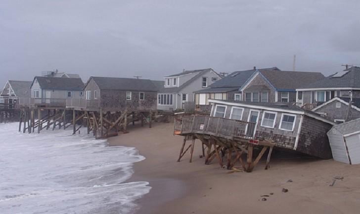
[Beachfront homes in the aftermath of Post-tropical Cyclone Sandy in 2012.]
From NOAA
The National Ocean Service (NOS) brings a wealth of coastal science, management, and operational expertise to aid communities impacted by severe weather events. We are on the front lines to help America understand, predict, and respond to the challenges facing our oceans and coasts. Following is an overview of our roles and responsibilities related to severe weather event preparedness, response, and recovery.
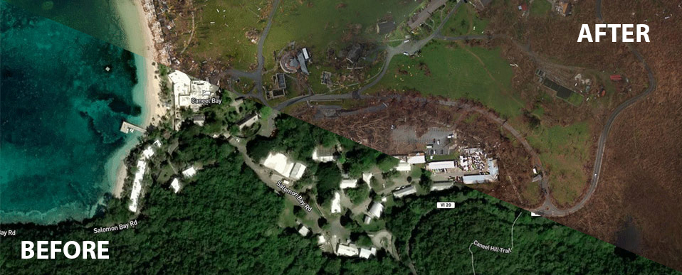 [A before-and-after split view of St. John, U.S. Virgin Islands, illustrating the effects of 2017's Hurricane Irma.]
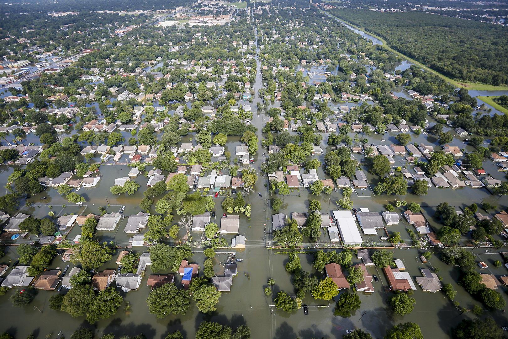 [Hurricane Harvey flooding. From South Carolina National Guard.]
Ready Before the Storm
NOS provides expertise in emergency response, coastal observations, and data modeling to prepare for, mitigate, and respond to severe weather events. To prepare for such events, NOAA performs planning exercises during times of “blue skies” to enhance our delivery of products and services aimed at helping communities recover from natural disasters, and to predict and be prepared for the next event. In terms of disaster preparedness, NOS brings together NOAA-wide resources to prepare federal, state, and local decision makers for a variety of hazards and threats. NOAA monitors and disseminates observations of water levels, currents, and weather information in real time through our National Water Level Observation Network and Physical Oceanographic Real-Time System (PORTS®). Collected real-time environmental information helps coastal authorities take action against storm tides and coastal flooding. NOAA also provides regular updates to Storm QuickLook, an online compilation of ocean and weather observations within a coastal area. When it comes to ocean and coastal observations, NOAA coordinates the U.S. Integrated Ocean Observing System (IOOS®), a federal, regional, and private-sector partnership that provides ocean and coastal data and information to support preparation and response efforts and to inform forecasts and predictions ahead of large storm events such as hurricanes. Before, during and after the storm, NOAA’s National Weather Service also keeps authorities aware of changing weather conditions that could impact recovery and response efforts.
[A before-and-after split view of St. John, U.S. Virgin Islands, illustrating the effects of 2017's Hurricane Irma.]
Rapid Storm Response
Following a severe weather event, NOS is one of the key partners to immediately respond with a wide range of activities. NOAA efforts focus on navigation surveys to restore maritime commerce; aerial surveys to assist in those efforts and to aid on-the-ground responders and local authorities; and oil spill cleanup and damage assessment. Immediately following a hurricane, NOAA provides emergency hydrographic services for affected port areas. These services are performed by Navigation Response Teams. These mobile emergency response units use echo sounders to check for submerged obstructions that pose hazards to vessels, collect data to update nautical charts, and provide mapping support. As soon as weather permits following major natural disasters, NOAA also begins aerial survey missions to assess damages to affected areas. These data and images provide emergency and coastal managers with information they need to develop recovery strategies, facilitate search-and-rescue efforts, identify hazards, locate errant vessels, and provide documentation necessary for damage assessment through the comparison of before-and-after imagery. Images are also available for the public to view and download as a tool to assess impacts to homes and communities. At the same time, NOAA provides scientific support to hazardous materials response efforts, and assesses the environmental impacts of contaminants in coastal and and estuarine waters and to the fish and shellfish there. We also provide guidance on marine debris and vessel salvage, conduct shoreline cleanup assessments, collect information to understand natural resource impacts from spills in affected areas, and work to address and restore resources injured by spills. To further aid resource managers in emergency response, NOAA provides static and real-time data analyses as well as maps depicting ecological impacts along the coast.
[Hurricane Harvey flooding. From South Carolina National Guard.]
Recovery from the Storm
NOAA leads coastal management efforts across the nation with its unique expertise in protecting coastal and estuarine habitats, reducing marine debris, and providing coastal mapping, observing, and monitoring, as well as highly accurate geospatial positioning services. In combination with decision support, technical assistance, and training activities, NOAA provides powerful resources, tools, and assistance to assist coastal communities with long-term recovery from severe weather events. Edited for WeatherNation by Meteorologist Mace MichaelsAll Weather News
More

Flooding, Severe Storms Target the Midwest Again
After an active week of storms across the nor
1 Aug 2026 1:40 AM


After Reaching Category 5, Genevieve Weakens in the Pacific
PacificFausto is now a post-tropical cyclone.
31 Jul 2026 1:30 AM

Flooding Risk Increases as Heavy Rain Targets the Tri-State Area
Tuesday, heavy rainfall moved across the Nort
30 Jul 2026 12:25 AM

Severe Weather: Energy From the Midwest Now in the Southeast
UPPER MIDWEST - Through Monday, dangerous tor
29 Jul 2026 10:30 PM