Rounding Up the Snow from the ND Blizzard of April 2022
Top Stories
15 Apr 2022 4:50 PM
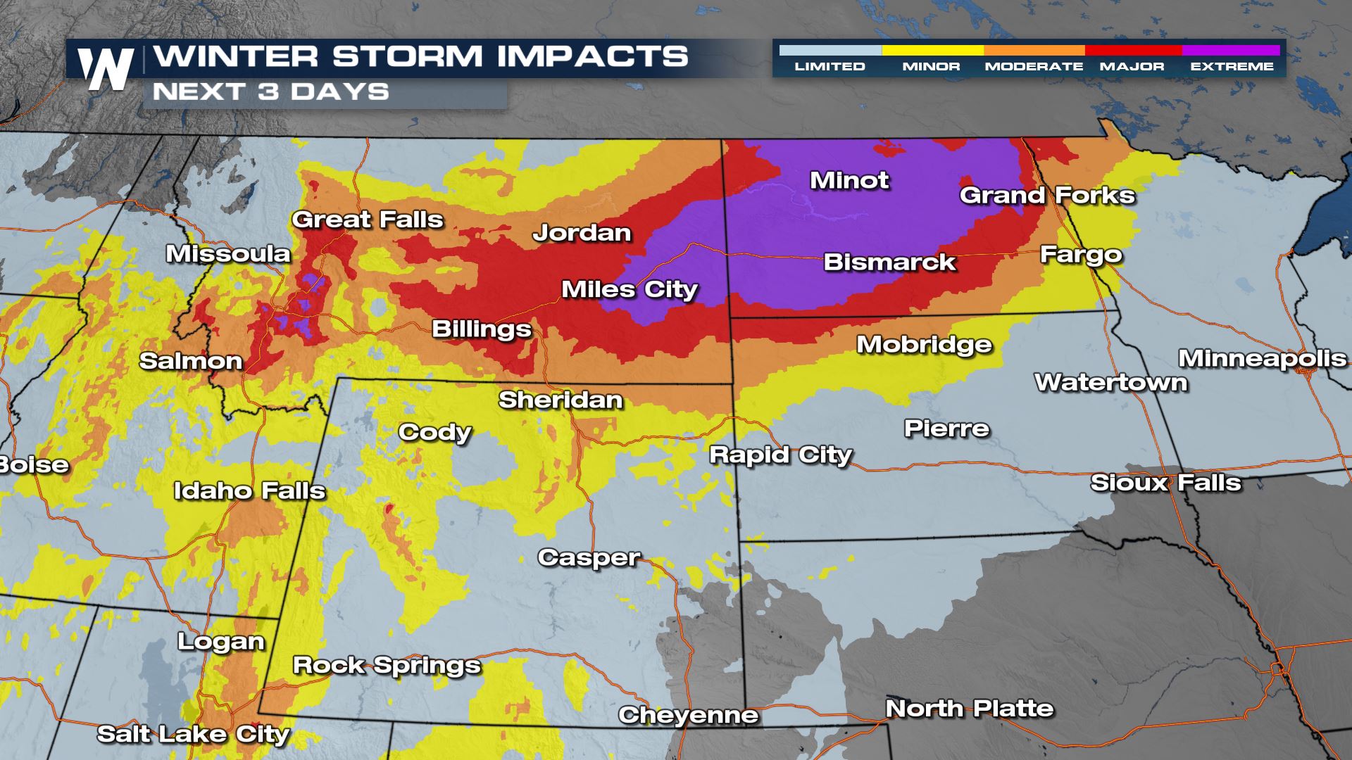
Blizzard conditions finally came to an end in the Northern Plains on Thursday, where Spring has felt a lot more like the heart of winter the last few days. Snowfall totals have been insanely high through Montana and North Dakota (above) with the energy now slowly weakening.
https://twitter.com/WeatherNation/status/1514634529750802437
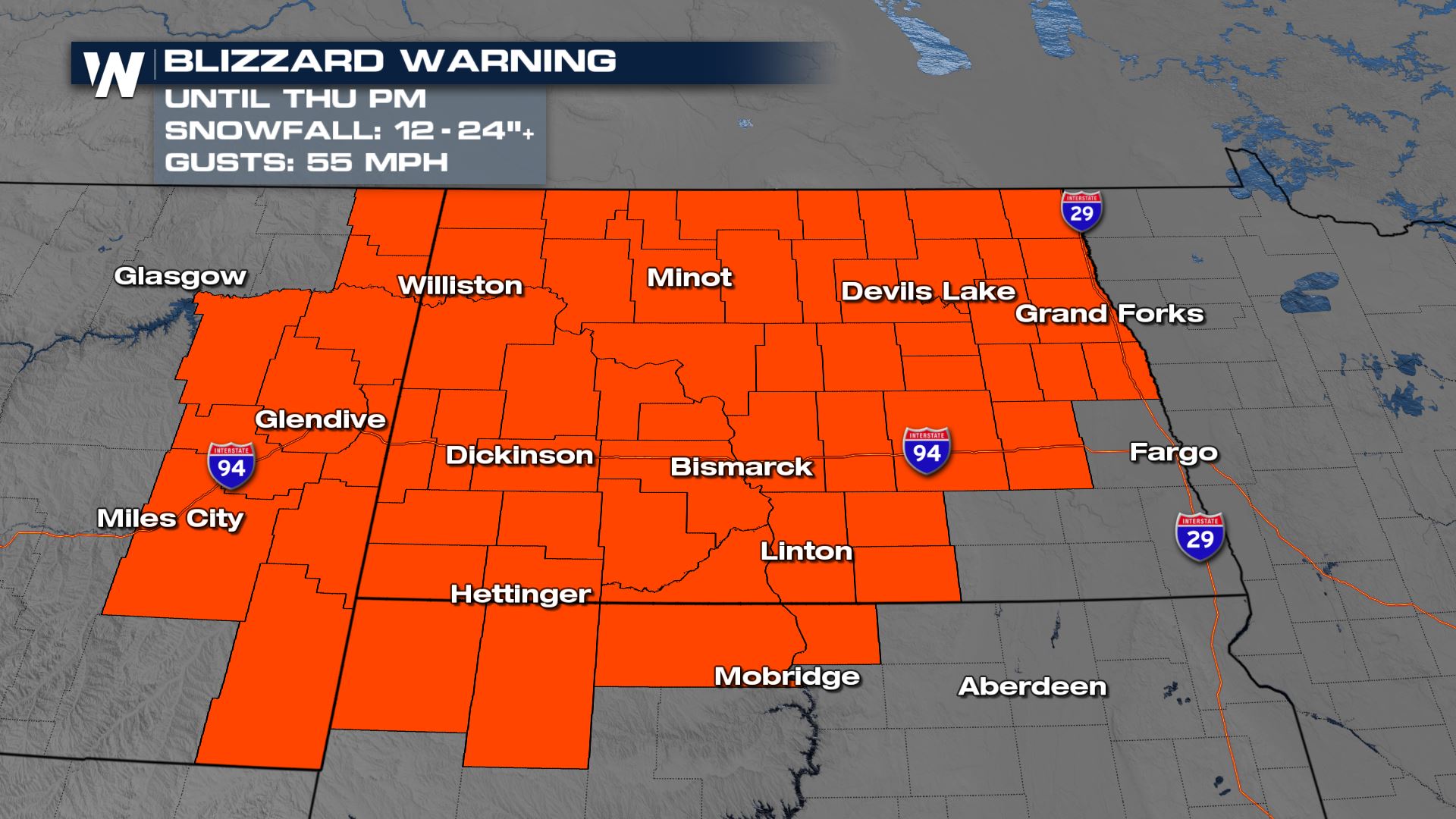
At the storms peak, we had nearly the entire state of North Dakota under blizzard warnings. Gusts we felt up to 55 mph.
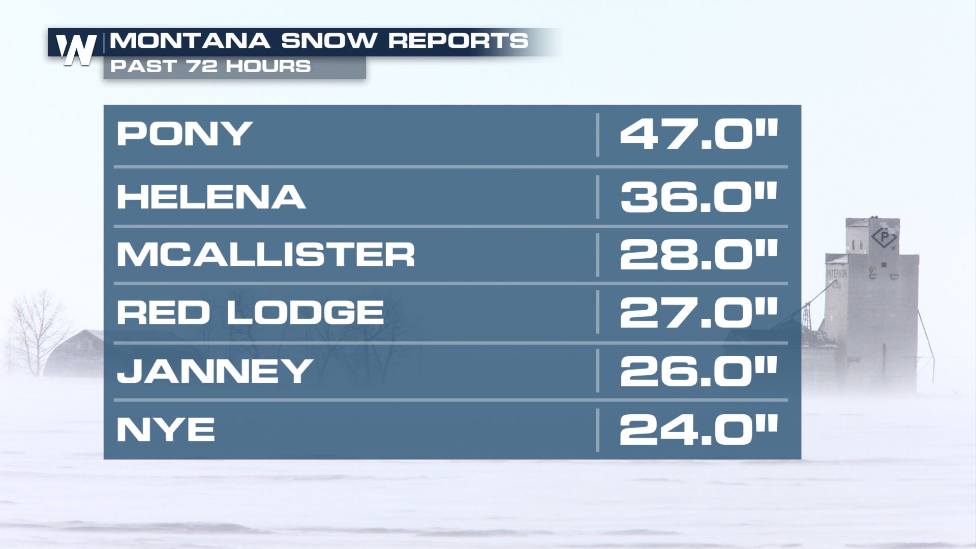
 The storm got its start in Montana, where some areas saw nearly four FEET of snow. We anticipate some higher snowfall amounts for these areas, but in January, not in the heart of April!
 As a result we saw major and extreme travel impacts for the northern Plains. Thankfully we didn't hear of any major accidents, as people heeded the winter warnings! North Dakota DOT also closed many major interstates during the storm.
https://twitter.com/NorthDakotaDOT/status/1514721167583576070?ref_src=twsrc%5Egoogle%7Ctwcamp%5Eserp%7Ctwgr%5Etweet
As a result we saw major and extreme travel impacts for the northern Plains. Thankfully we didn't hear of any major accidents, as people heeded the winter warnings! North Dakota DOT also closed many major interstates during the storm.
https://twitter.com/NorthDakotaDOT/status/1514721167583576070?ref_src=twsrc%5Egoogle%7Ctwcamp%5Eserp%7Ctwgr%5Etweet
 https://twitter.com/NorthDakotaDOT/status/1514664416561688583
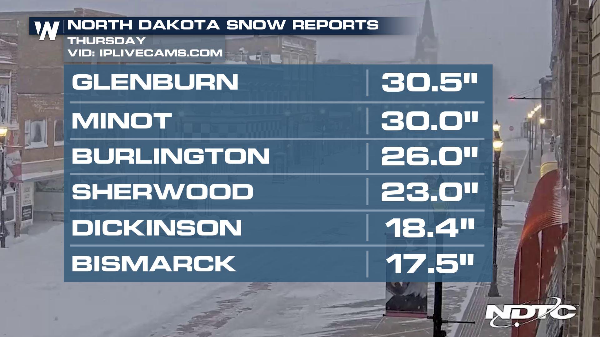
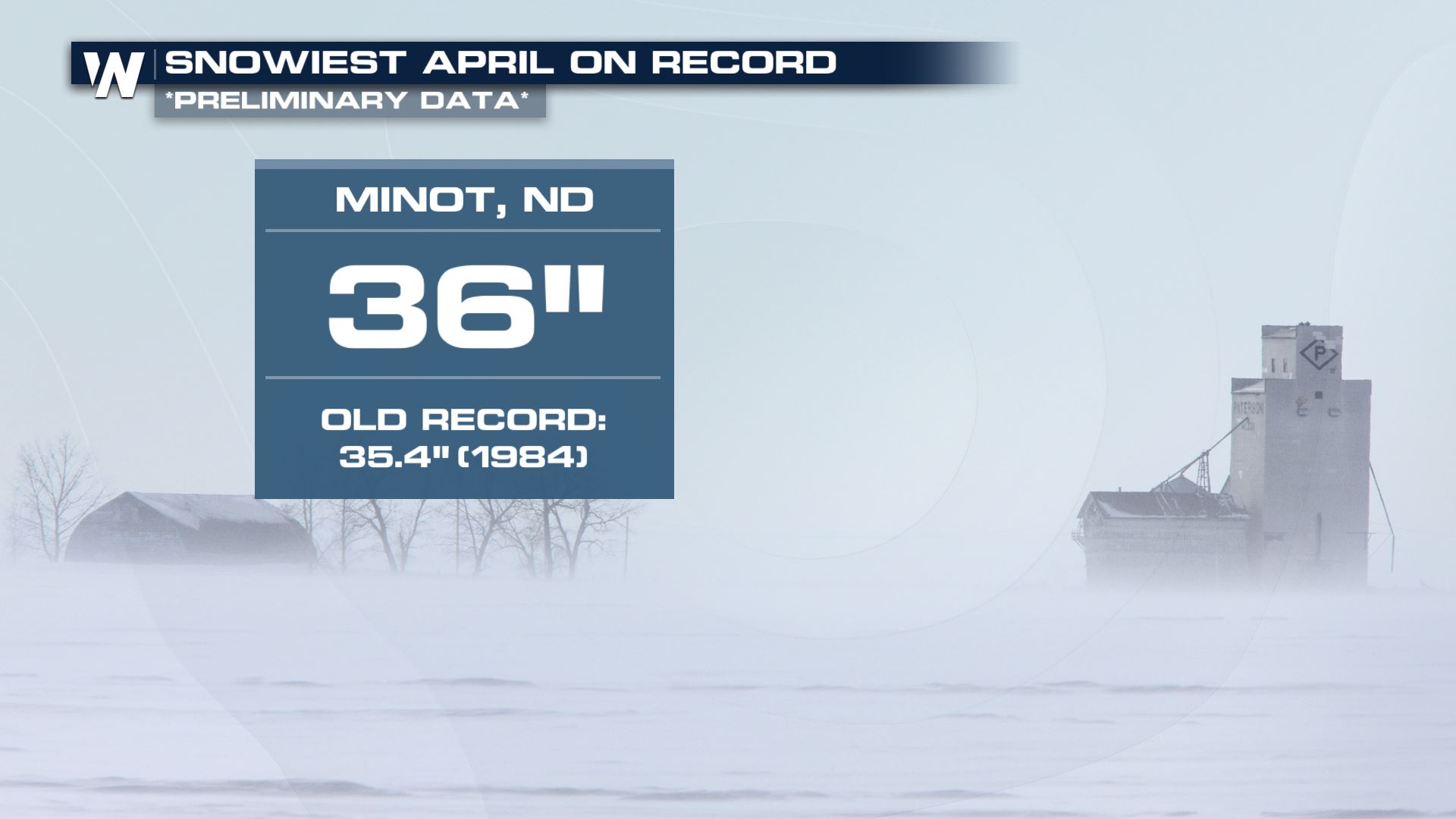
Minot, North Dakota picked up on 3 FEET of snow with this system. This now makes April 2022 the snowiest April on record for the city!
https://twitter.com/NorthDakotaDOT/status/1514664416561688583
Minot, North Dakota picked up on 3 FEET of snow with this system. This now makes April 2022 the snowiest April on record for the city!
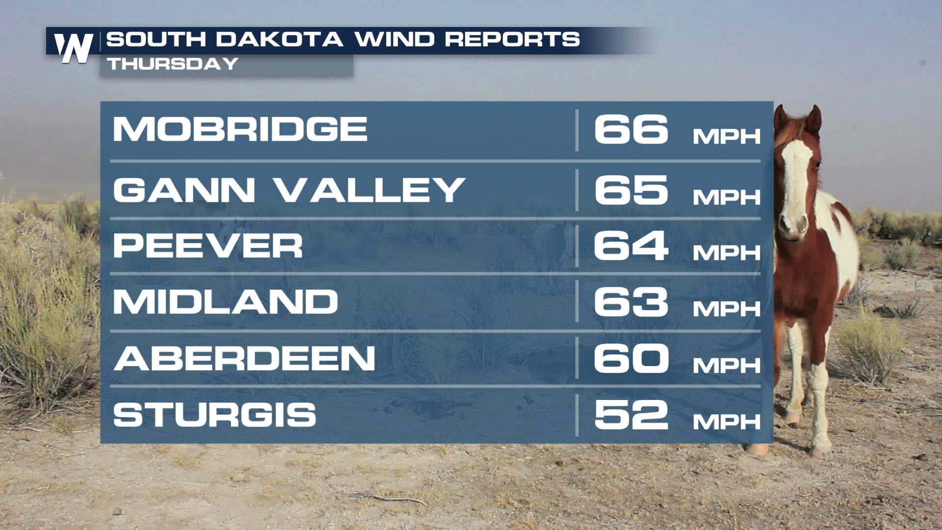
 The other factor of this system is the wind away from where the snow is. Extreme fire danger concerns are in play for South Dakota where we have seen wind gusts over 60 mph the last few days.
 Stay with WeatherNation for the forecast details on this active Easter Weekend forecast. We're streaming 24/7 with your Central Regional Forecast every :30 past the hour.
The storm got its start in Montana, where some areas saw nearly four FEET of snow. We anticipate some higher snowfall amounts for these areas, but in January, not in the heart of April!
As a result we saw major and extreme travel impacts for the northern Plains. Thankfully we didn't hear of any major accidents, as people heeded the winter warnings! North Dakota DOT also closed many major interstates during the storm.
https://twitter.com/NorthDakotaDOT/status/1514721167583576070?ref_src=twsrc%5Egoogle%7Ctwcamp%5Eserp%7Ctwgr%5Etweet
https://twitter.com/NorthDakotaDOT/status/1514664416561688583
Minot, North Dakota picked up on 3 FEET of snow with this system. This now makes April 2022 the snowiest April on record for the city!
The other factor of this system is the wind away from where the snow is. Extreme fire danger concerns are in play for South Dakota where we have seen wind gusts over 60 mph the last few days.
Stay with WeatherNation for the forecast details on this active Easter Weekend forecast. We're streaming 24/7 with your Central Regional Forecast every :30 past the hour.All Weather News
More
Texas and Oklahoma Severe Chances Friday
Another round of severe storms will be possib
22 May 2026 1:30 PM

Severe Storms, Heavy Rain Target the Southeast
Heavy rain has already hit numerous areas in
22 May 2026 12:02 PM

NOAA Predicts Below Normal 2026 Hurricane Season
NOAA has released their predictions for the 2
22 May 2026 12:00 PM

Repeated Rain Raises the Flood Threat
A slow-moving frontal boundary that brought n
22 May 2026 10:25 AM

NOAA Releases Summer Outlook, Above Average Temperatures Expected
The National Oceanic and Atmospheric Administ
22 May 2026 9:05 AM

CALIFORNIA: Wildfires Prompt Evacuations
SIMI VALLEY, CA - On Monday, May 18th in Vent
22 May 2026 2:00 AM

Rockies Brace for Snow, Severe Storms as Cold Front Moves In
ROCKIES - Through the rest of the week, an up
21 May 2026 5:30 PM