Satellite Data Predicts Future Lightning Strikes
Special Stories
26 Aug 2021 2:00 AM
[Written by NOAA NESDIS] Lightning is a major hazard. It’s a significant threat to life and property, can ignite wildfires, and impacts travel. Lightning can strike at any time, but it is most common in the summer months. The GOES-R Geostationary Lightning Mapper (GLM), the first instrument of its kind in geostationary orbit, has revolutionized lightning detection. Now, GLM can not only detect current lightning activity, but its data can also help predict the occurrence of lightning in the future.
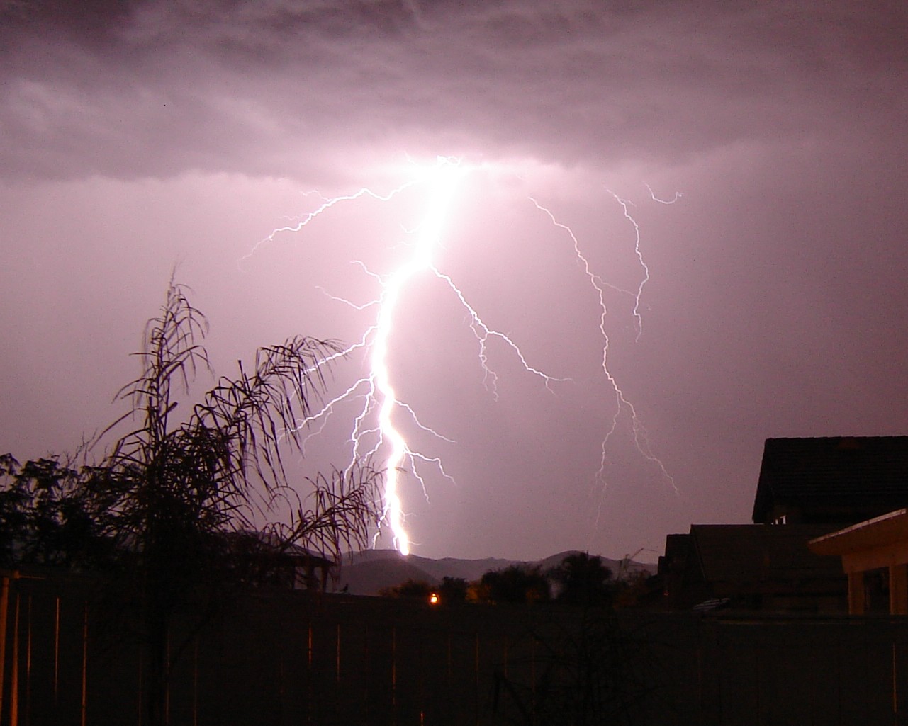 [Lightning captured in Temescal Valley, California. Credit: Willi Wilkins.]
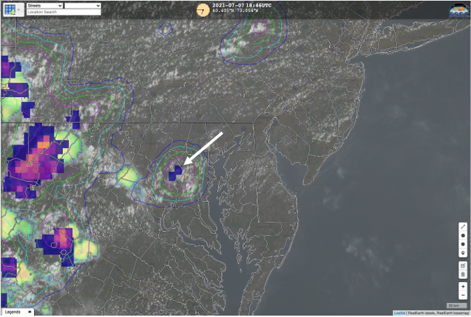
Scientists are using artificial intelligence (AI) to predict where GLM will observe lightning in the future. To accomplish this, a sophisticated machine-learning algorithm was trained, using GLM data, to recognize complex patterns in GOES-R Advanced Baseline Imager (ABI) imagery that often precede lightning activity detected by GLM. This AI model skillfully and reliably predicts where lightning is most likely to occur even before precipitation forms. It also indicates where lightning remains a threat in storms with intermittent lightning activity and helps determine when the threat from lightning is diminishing.
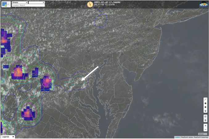
The AI tool can accurately predict lightning up to 60 minutes before the first observation of lightning flashes. Clear predictive signals often emerge before rain forms, ahead of weather radar signals. An example from Washington, D.C. on July 7, 2021, shows a lightning probability signal occurring 50 minutes before the first instance of lightning.
At 1:56 p.m. EST, the AI lightning prediction tool indicated a greater than 25% chance of lightning occurring in the next hour. No rain was present at that time.
[Lightning captured in Temescal Valley, California. Credit: Willi Wilkins.]
Scientists are using artificial intelligence (AI) to predict where GLM will observe lightning in the future. To accomplish this, a sophisticated machine-learning algorithm was trained, using GLM data, to recognize complex patterns in GOES-R Advanced Baseline Imager (ABI) imagery that often precede lightning activity detected by GLM. This AI model skillfully and reliably predicts where lightning is most likely to occur even before precipitation forms. It also indicates where lightning remains a threat in storms with intermittent lightning activity and helps determine when the threat from lightning is diminishing.
The AI tool can accurately predict lightning up to 60 minutes before the first observation of lightning flashes. Clear predictive signals often emerge before rain forms, ahead of weather radar signals. An example from Washington, D.C. on July 7, 2021, shows a lightning probability signal occurring 50 minutes before the first instance of lightning.
At 1:56 p.m. EST, the AI lightning prediction tool indicated a greater than 25% chance of lightning occurring in the next hour. No rain was present at that time.
 At 2:21 p.m. EST, the lightning prediction tool indicated a greater than 75% chance of lightning occurring in the next hour. It was still not raining in the area.
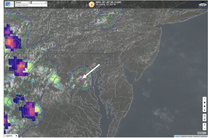 At 2:46 p.m. EST, lightning was observed by the GLM, shortly after it began to rain.
 This new experimental AI application is currently being tested in real-time and has the potential to significantly improve guidance for aviation and marine transportation as well as decision support services for outdoor recreational activities like sporting events, festivals, and theme parks. It could even help predict when lightning may strike areas primed for lightning-ignited wildfires, such as those with an abundance of dry fuels experiencing specific weather patterns like high-pressure cells over the western United States that contain moist, monsoon-like air masses.
https://www.youtube.com/watch?v=uOCTI2Mw97M
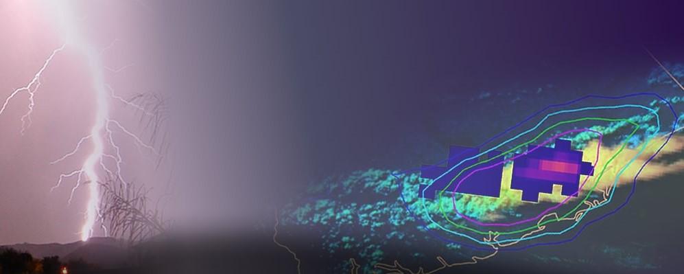
[Probability of lightning occurring in the next 60 minutes plotted for the coast of South Carolina on July 14, 2021, along with GLM flash-extent density data when lightning was detected. Credit: NOAA/CIMSS]
This tool was developed by John Cintineo at the University of Wisconsin/Cooperative Institute for Meteorological Satellite Studies (CIMSS), as part of ProbSevere, a statistical model that predicts the probability that a storm will produce severe weather in the near-term. Mike Pavolonis, the NOAA scientist who leads the ProbSevere project, praised the new application. “As John’s work shows, machine learning is opening the door to new satellite applications that directly address major societal challenges in ways that were not previously possible,” said Pavolonis.
The advanced data provided by GOES-16 (GOES East) and GOES-17 (GOES West) allow for new and innovative applications. Not only is the satellite data useful for depicting current weather conditions, but it is also critical for predicting hazardous conditions in the future. This lightning prediction AI tool demonstrates a new way to use satellite data to help keep us informed and stay safe.
Check out the experimental near real-time probability of lightning data.
This new experimental AI application is currently being tested in real-time and has the potential to significantly improve guidance for aviation and marine transportation as well as decision support services for outdoor recreational activities like sporting events, festivals, and theme parks. It could even help predict when lightning may strike areas primed for lightning-ignited wildfires, such as those with an abundance of dry fuels experiencing specific weather patterns like high-pressure cells over the western United States that contain moist, monsoon-like air masses.
https://www.youtube.com/watch?v=uOCTI2Mw97M
[Probability of lightning occurring in the next 60 minutes plotted for the coast of South Carolina on July 14, 2021, along with GLM flash-extent density data when lightning was detected. Credit: NOAA/CIMSS]
This tool was developed by John Cintineo at the University of Wisconsin/Cooperative Institute for Meteorological Satellite Studies (CIMSS), as part of ProbSevere, a statistical model that predicts the probability that a storm will produce severe weather in the near-term. Mike Pavolonis, the NOAA scientist who leads the ProbSevere project, praised the new application. “As John’s work shows, machine learning is opening the door to new satellite applications that directly address major societal challenges in ways that were not previously possible,” said Pavolonis.
The advanced data provided by GOES-16 (GOES East) and GOES-17 (GOES West) allow for new and innovative applications. Not only is the satellite data useful for depicting current weather conditions, but it is also critical for predicting hazardous conditions in the future. This lightning prediction AI tool demonstrates a new way to use satellite data to help keep us informed and stay safe.
Check out the experimental near real-time probability of lightning data.
[Lightning captured in Temescal Valley, California. Credit: Willi Wilkins.]
Scientists are using artificial intelligence (AI) to predict where GLM will observe lightning in the future. To accomplish this, a sophisticated machine-learning algorithm was trained, using GLM data, to recognize complex patterns in GOES-R Advanced Baseline Imager (ABI) imagery that often precede lightning activity detected by GLM. This AI model skillfully and reliably predicts where lightning is most likely to occur even before precipitation forms. It also indicates where lightning remains a threat in storms with intermittent lightning activity and helps determine when the threat from lightning is diminishing.
The AI tool can accurately predict lightning up to 60 minutes before the first observation of lightning flashes. Clear predictive signals often emerge before rain forms, ahead of weather radar signals. An example from Washington, D.C. on July 7, 2021, shows a lightning probability signal occurring 50 minutes before the first instance of lightning.
At 1:56 p.m. EST, the AI lightning prediction tool indicated a greater than 25% chance of lightning occurring in the next hour. No rain was present at that time.
At 2:21 p.m. EST, the lightning prediction tool indicated a greater than 75% chance of lightning occurring in the next hour. It was still not raining in the area.
At 2:46 p.m. EST, lightning was observed by the GLM, shortly after it began to rain.
This new experimental AI application is currently being tested in real-time and has the potential to significantly improve guidance for aviation and marine transportation as well as decision support services for outdoor recreational activities like sporting events, festivals, and theme parks. It could even help predict when lightning may strike areas primed for lightning-ignited wildfires, such as those with an abundance of dry fuels experiencing specific weather patterns like high-pressure cells over the western United States that contain moist, monsoon-like air masses.
https://www.youtube.com/watch?v=uOCTI2Mw97M
[Probability of lightning occurring in the next 60 minutes plotted for the coast of South Carolina on July 14, 2021, along with GLM flash-extent density data when lightning was detected. Credit: NOAA/CIMSS]
This tool was developed by John Cintineo at the University of Wisconsin/Cooperative Institute for Meteorological Satellite Studies (CIMSS), as part of ProbSevere, a statistical model that predicts the probability that a storm will produce severe weather in the near-term. Mike Pavolonis, the NOAA scientist who leads the ProbSevere project, praised the new application. “As John’s work shows, machine learning is opening the door to new satellite applications that directly address major societal challenges in ways that were not previously possible,” said Pavolonis.
The advanced data provided by GOES-16 (GOES East) and GOES-17 (GOES West) allow for new and innovative applications. Not only is the satellite data useful for depicting current weather conditions, but it is also critical for predicting hazardous conditions in the future. This lightning prediction AI tool demonstrates a new way to use satellite data to help keep us informed and stay safe.
Check out the experimental near real-time probability of lightning data.
All Weather News
More
East Gears Up for Stormy, Wet Weekend
A low pressure system crashing through the Mi
1 Aug 2026 11:35 AM


Flooding, Severe Storms Target the Midwest Again
After an active week of storms across the nor
1 Aug 2026 1:40 AM


After Reaching Category 5, Genevieve Weakens in the Pacific
PacificFausto is now a post-tropical cyclone.
31 Jul 2026 1:30 AM

Flooding Risk Increases as Heavy Rain Targets the Tri-State Area
Tuesday, heavy rainfall moved across the Nort
30 Jul 2026 12:25 AM

Severe Weather: Energy From the Midwest Now in the Southeast
UPPER MIDWEST - Through Monday, dangerous tor
29 Jul 2026 10:30 PM