Busiest severe weather day in 2+ months
Top Stories
29 Mar 2020 8:58 AM
Saturday's severe weather outbreak was the biggest nationwide day for severe storm reports in over two months, based on preliminary figures from the Storm Prediction Center (SPC).
Based on initial severe weather reports from Saturday's outbreak, there were at least 261 reports of severe weather nationwide on Saturday. That made Saturday the busiest day for severe weather (in terms of total severe weather reports) since January 11th, and the third-busiest day so far this year.
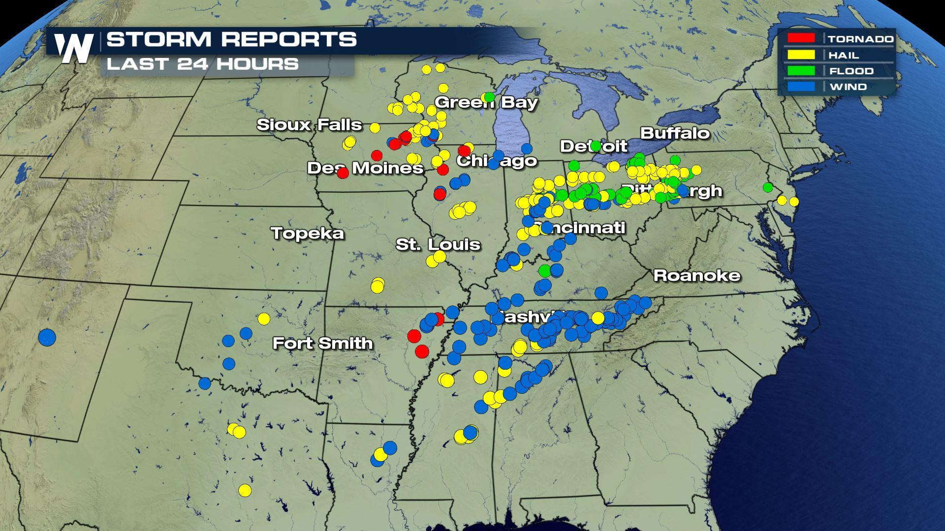
 Severe weather reports include all modes of severe weather, including tornadoes, hail of an inch in diameter or greater, and damaging wind gusts or wind gusts in excess of 58 mph. In the map above, yellow dots indicate large hail reports, reds indicate tornado reports and blue dots indicate wind damage or gust reports. Green dots indicate flood reports, though to be clear, flood reports don't factor into severe weather reports.
The severe weather reports did include at least 17 preliminary reports of tornadoes, including the large tornado that moved through Jonesboro, Arkansas. The 17-tornado report figure, by the way, was the fourth-highest nationwide total so far this year.
Note the clustering of red dots in northeastern Arkansas from the map - that's the Jonesboro tornado as it quickly developed right over the city before moving northeast. Also, a huge swath of wind damage reports (blue dots) clustered across Tennessee and northern Alabama, most of which took place late on Saturday night.
Large hail also accompanied Saturday's storms, mainly in Indiana and Ohio on Saturday afternoon.
https://twitter.com/WeatherNation/status/1244187543295283201?s=20
It's also worth noting that some of these reports may be duplicates, and some of these reports may be filtered out in the coming days.
More severe storms are in the forecast for Sunday and Monday. For more details on Sunday's threat specifically, meteorologist Patrick Crawford has more here.
Severe weather reports include all modes of severe weather, including tornadoes, hail of an inch in diameter or greater, and damaging wind gusts or wind gusts in excess of 58 mph. In the map above, yellow dots indicate large hail reports, reds indicate tornado reports and blue dots indicate wind damage or gust reports. Green dots indicate flood reports, though to be clear, flood reports don't factor into severe weather reports.
The severe weather reports did include at least 17 preliminary reports of tornadoes, including the large tornado that moved through Jonesboro, Arkansas. The 17-tornado report figure, by the way, was the fourth-highest nationwide total so far this year.
Note the clustering of red dots in northeastern Arkansas from the map - that's the Jonesboro tornado as it quickly developed right over the city before moving northeast. Also, a huge swath of wind damage reports (blue dots) clustered across Tennessee and northern Alabama, most of which took place late on Saturday night.
Large hail also accompanied Saturday's storms, mainly in Indiana and Ohio on Saturday afternoon.
https://twitter.com/WeatherNation/status/1244187543295283201?s=20
It's also worth noting that some of these reports may be duplicates, and some of these reports may be filtered out in the coming days.
More severe storms are in the forecast for Sunday and Monday. For more details on Sunday's threat specifically, meteorologist Patrick Crawford has more here.
 Stay with WeatherNation for the latest on these storms and for the latest on severe weather.
Severe weather reports include all modes of severe weather, including tornadoes, hail of an inch in diameter or greater, and damaging wind gusts or wind gusts in excess of 58 mph. In the map above, yellow dots indicate large hail reports, reds indicate tornado reports and blue dots indicate wind damage or gust reports. Green dots indicate flood reports, though to be clear, flood reports don't factor into severe weather reports.
The severe weather reports did include at least 17 preliminary reports of tornadoes, including the large tornado that moved through Jonesboro, Arkansas. The 17-tornado report figure, by the way, was the fourth-highest nationwide total so far this year.
Note the clustering of red dots in northeastern Arkansas from the map - that's the Jonesboro tornado as it quickly developed right over the city before moving northeast. Also, a huge swath of wind damage reports (blue dots) clustered across Tennessee and northern Alabama, most of which took place late on Saturday night.
Large hail also accompanied Saturday's storms, mainly in Indiana and Ohio on Saturday afternoon.
https://twitter.com/WeatherNation/status/1244187543295283201?s=20
It's also worth noting that some of these reports may be duplicates, and some of these reports may be filtered out in the coming days.
More severe storms are in the forecast for Sunday and Monday. For more details on Sunday's threat specifically, meteorologist Patrick Crawford has more here.
Stay with WeatherNation for the latest on these storms and for the latest on severe weather.All Weather News
More
Texas and Oklahoma Severe Chances Friday
Another round of severe storms will be possib
22 May 2026 1:30 PM

Severe Storms, Heavy Rain Target the Southeast
Heavy rain has already hit numerous areas in
22 May 2026 12:02 PM

NOAA Predicts Below Normal 2026 Hurricane Season
NOAA has released their predictions for the 2
22 May 2026 12:00 PM

Repeated Rain Raises the Flood Threat
A slow-moving frontal boundary that brought n
22 May 2026 10:25 AM

NOAA Releases Summer Outlook, Above Average Temperatures Expected
The National Oceanic and Atmospheric Administ
22 May 2026 9:05 AM

CALIFORNIA: Wildfires Prompt Evacuations
SIMI VALLEY, CA - On Monday, May 18th in Vent
22 May 2026 2:00 AM

Rockies Brace for Snow, Severe Storms as Cold Front Moves In
ROCKIES - Through the rest of the week, an up
21 May 2026 5:30 PM