Several Days of Severe Weather Ahead
Top Stories
18 Mar 2018 11:56 AM
Just after severe storms rolled through eastern Texas and eastern Tennessee just yesterday, we have more severe possibilities to discuss.
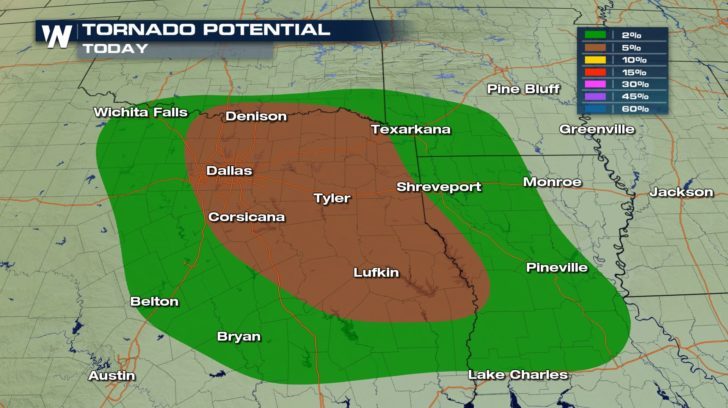
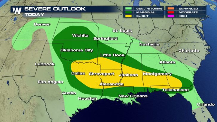 The areas shaded in the yellow and darker green are regions that are more likely to see severe storms today. This is where a warm front is moving through the region. This risk for severe storms will bring the potential for heavy rain, strong winds with gusts upwards of 60 mph, hail and tornadoes. The best chance for tornadoes to form will be across eastern Texas and into Louisiana.
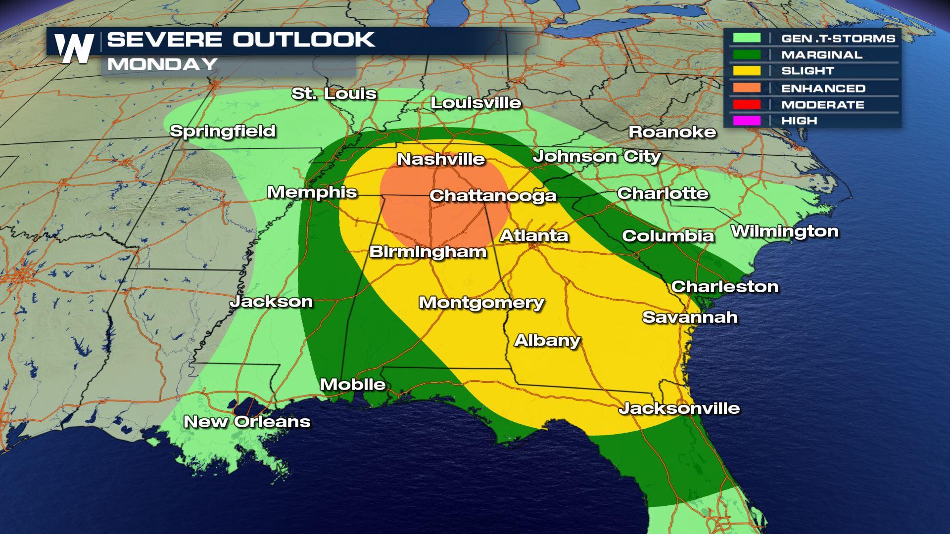
 The threat for severe storm continue into Monday as well. The areas of low pressure heads eastward and brings even a greater chance for a severe outbreak across the Tennessee River Valley.
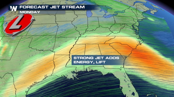
 The threat looks to be increased tomorrow because of the atmosphere's set-up. We will have a jet stream max across the region. This allows those storms to grow and build and potentially last longer.
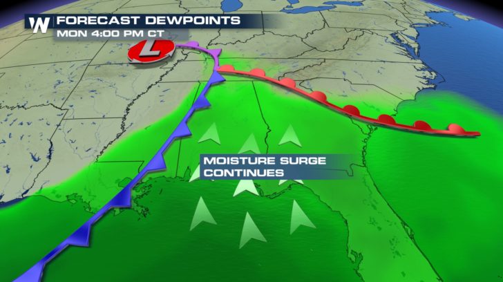
 Another factor that will go into the severe potential will be the amount of moisture in the atmosphere. For that, we look at the dewpoints. In the warm sector, southerly flow might get those dewpoints in the 60s. That's extra buoyancy in the atmosphere to help grow storms.
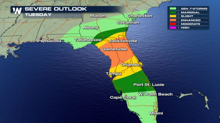
 Even as we head into Tuesday, the chance for severe storms remain. This time it will be across southern Georgia and into Florida. The low pressure system's cold front will be working through the region and potentially firing off more strong to severe storms.
The areas shaded in the yellow and darker green are regions that are more likely to see severe storms today. This is where a warm front is moving through the region. This risk for severe storms will bring the potential for heavy rain, strong winds with gusts upwards of 60 mph, hail and tornadoes. The best chance for tornadoes to form will be across eastern Texas and into Louisiana.
The threat for severe storm continue into Monday as well. The areas of low pressure heads eastward and brings even a greater chance for a severe outbreak across the Tennessee River Valley.
The threat looks to be increased tomorrow because of the atmosphere's set-up. We will have a jet stream max across the region. This allows those storms to grow and build and potentially last longer.
Another factor that will go into the severe potential will be the amount of moisture in the atmosphere. For that, we look at the dewpoints. In the warm sector, southerly flow might get those dewpoints in the 60s. That's extra buoyancy in the atmosphere to help grow storms.
Even as we head into Tuesday, the chance for severe storms remain. This time it will be across southern Georgia and into Florida. The low pressure system's cold front will be working through the region and potentially firing off more strong to severe storms.
All Weather News
More
More Storms for the East Through Monday
A low-pressure system that moved through the
2 Aug 2026 10:40 PM

Wildfire Outbreak in the Pacific Northwest
SPOKANE, WA - On Saturday, August 1st, the Ol
2 Aug 2026 10:35 PM


After Reaching Category 5, Genevieve Weakens in the Pacific
PacificGenevieve formed on last Friday south
2 Aug 2026 6:25 PM

Flooding, Severe Storms Target the Midwest Again
After an active week of storms across the nor
1 Aug 2026 1:40 AM

Flooding Risk Increases as Heavy Rain Targets the Tri-State Area
Tuesday, heavy rainfall moved across the Nort
30 Jul 2026 12:25 AM

Severe Weather: Energy From the Midwest Now in the Southeast
UPPER MIDWEST - Through Monday, dangerous tor
29 Jul 2026 10:30 PM