Severe Risk UPGRADED
Top Stories
23 Jun 2018 3:43 PM
Destructive thunderstorms appear likely across parts of the Plains on Sunday.
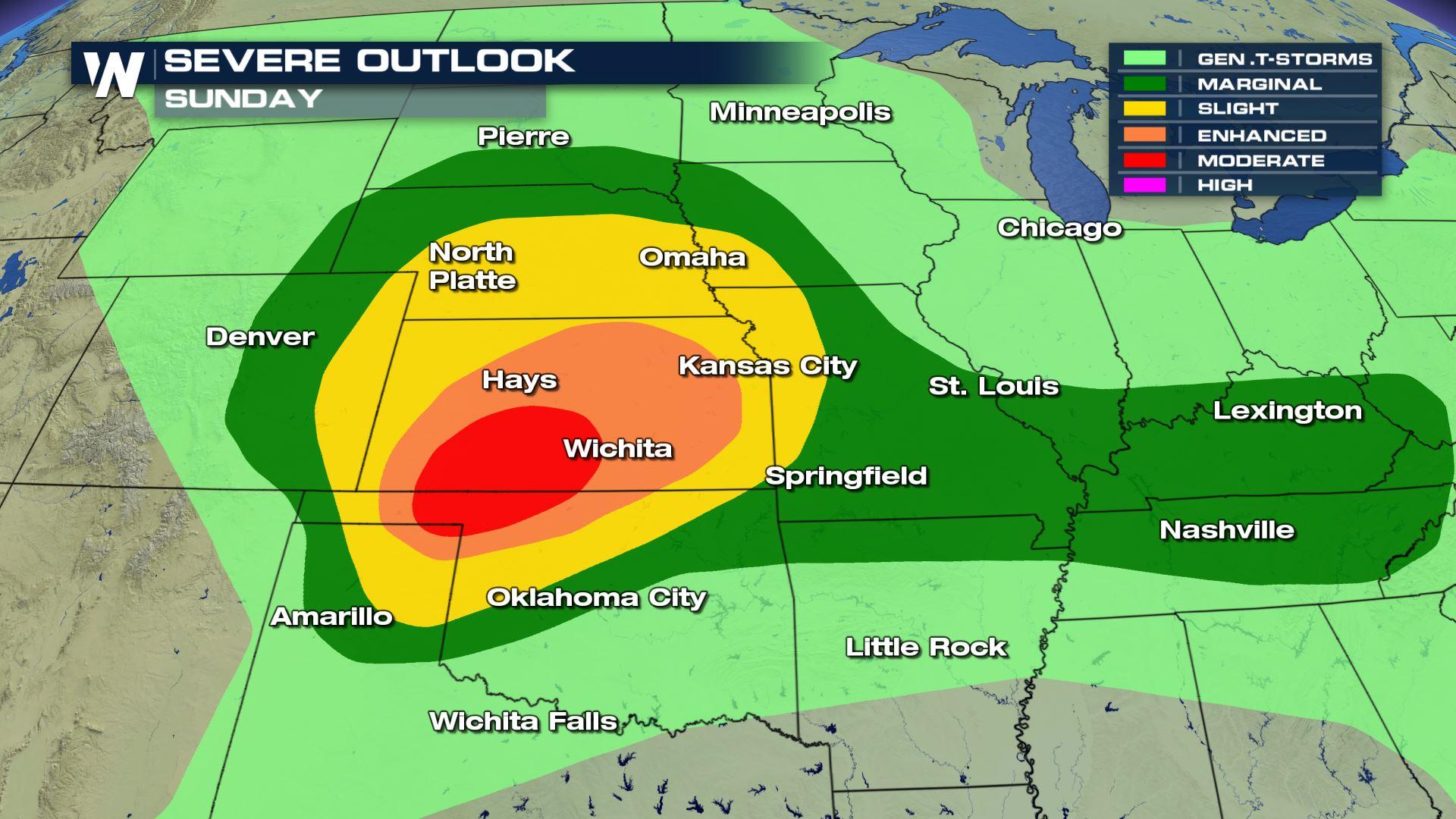
 Severe thunderstorms will have the potential to produce destructive wind gusts, very large hail and even tornadoes across much of Kansas, northern Oklahoma and parts of the eastern Texas Panhandle on Sunday. Severe weather parameters are looking increasingly favorable for destructive storms to ignite Sunday afternoon and that is why the Storm Prediction Center put out a Moderate Risk for the area.
https://twitter.com/WeatherNation/status/1010580939250909184
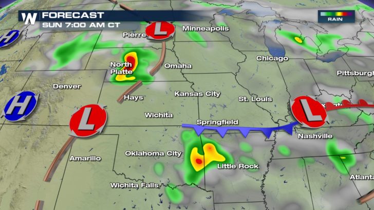
Thunderstorms are expected to be ongoing across parts of Nebraska by early Sunday morning. Meanwhile, parts of Kansas and Oklahoma start off the day with sunshine. The more sun that exists across the area, the more instability that develops and the more widespread the severe storms will be.
Severe thunderstorms will have the potential to produce destructive wind gusts, very large hail and even tornadoes across much of Kansas, northern Oklahoma and parts of the eastern Texas Panhandle on Sunday. Severe weather parameters are looking increasingly favorable for destructive storms to ignite Sunday afternoon and that is why the Storm Prediction Center put out a Moderate Risk for the area.
https://twitter.com/WeatherNation/status/1010580939250909184
Thunderstorms are expected to be ongoing across parts of Nebraska by early Sunday morning. Meanwhile, parts of Kansas and Oklahoma start off the day with sunshine. The more sun that exists across the area, the more instability that develops and the more widespread the severe storms will be.
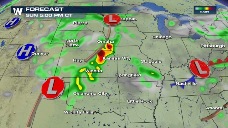
 After lunch on Sunday, storms will begin to fire up across parts of Kansas and Oklahoma. Discreet supercells will be favorable at this stage posing a tornado threat.
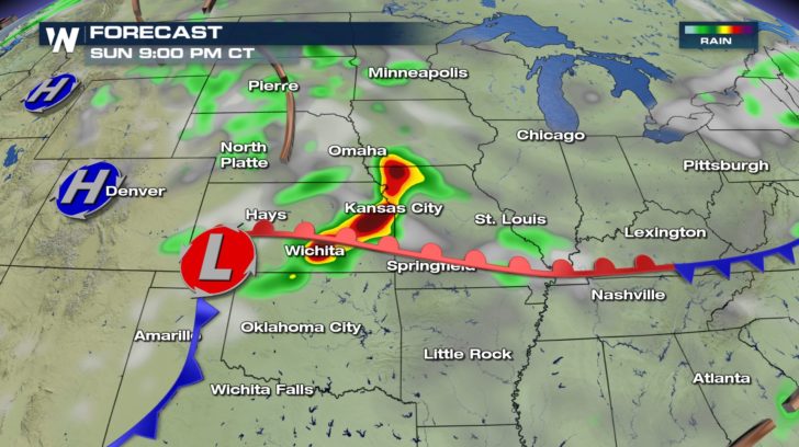
 By dinner time, thunderstorms are expected to evolve into a line of severe thunderstorms where the main threat transitions to destructive wind gusts.
This line of damaging thunderstorms is expected to push south and east through Sunday night where gusts may exceed 80 mph. A similar event produced gusts near 90 mph over northwest Oklahoma on Friday night.
By dinner time, thunderstorms are expected to evolve into a line of severe thunderstorms where the main threat transitions to destructive wind gusts.
This line of damaging thunderstorms is expected to push south and east through Sunday night where gusts may exceed 80 mph. A similar event produced gusts near 90 mph over northwest Oklahoma on Friday night.
 By Monday, the severe threat shifts east with the greatest concern for severe storms in the warm sector (area between the warm front and the cold front).
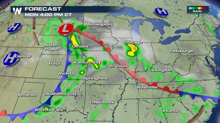 Cities at risk for severe storms on Monday include Des Moines, Kansas City, St. Louis and Omaha.
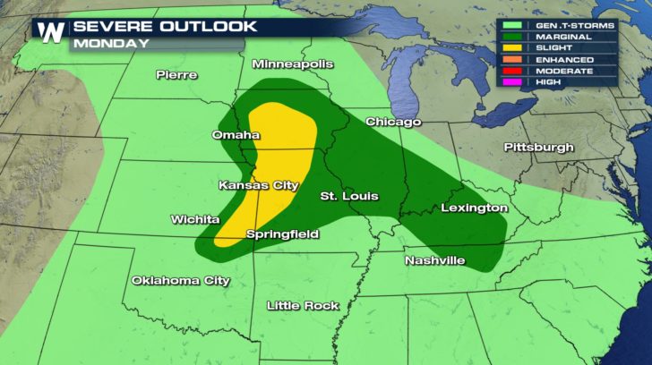 Thunderstorms for Monday are not expected to be as widespread nor as dangerous as Sunday evening thunderstorms.
For WeatherNation: Meteorologist Nick Merianos
Thunderstorms for Monday are not expected to be as widespread nor as dangerous as Sunday evening thunderstorms.
For WeatherNation: Meteorologist Nick Merianos
Severe thunderstorms will have the potential to produce destructive wind gusts, very large hail and even tornadoes across much of Kansas, northern Oklahoma and parts of the eastern Texas Panhandle on Sunday. Severe weather parameters are looking increasingly favorable for destructive storms to ignite Sunday afternoon and that is why the Storm Prediction Center put out a Moderate Risk for the area.
https://twitter.com/WeatherNation/status/1010580939250909184
Thunderstorms are expected to be ongoing across parts of Nebraska by early Sunday morning. Meanwhile, parts of Kansas and Oklahoma start off the day with sunshine. The more sun that exists across the area, the more instability that develops and the more widespread the severe storms will be.
After lunch on Sunday, storms will begin to fire up across parts of Kansas and Oklahoma. Discreet supercells will be favorable at this stage posing a tornado threat.
By dinner time, thunderstorms are expected to evolve into a line of severe thunderstorms where the main threat transitions to destructive wind gusts.
This line of damaging thunderstorms is expected to push south and east through Sunday night where gusts may exceed 80 mph. A similar event produced gusts near 90 mph over northwest Oklahoma on Friday night.
By Monday, the severe threat shifts east with the greatest concern for severe storms in the warm sector (area between the warm front and the cold front).
Cities at risk for severe storms on Monday include Des Moines, Kansas City, St. Louis and Omaha.
Thunderstorms for Monday are not expected to be as widespread nor as dangerous as Sunday evening thunderstorms.
For WeatherNation: Meteorologist Nick Merianos
All Weather News
More

East Gears Up for Stormy, Wet Weekend
A low pressure system crashing through the Mi
1 Aug 2026 9:15 PM


Flooding, Severe Storms Target the Midwest Again
After an active week of storms across the nor
1 Aug 2026 1:40 AM

After Reaching Category 5, Genevieve Weakens in the Pacific
PacificFausto is now a post-tropical cyclone.
31 Jul 2026 1:30 AM

Flooding Risk Increases as Heavy Rain Targets the Tri-State Area
Tuesday, heavy rainfall moved across the Nort
30 Jul 2026 12:25 AM

Severe Weather: Energy From the Midwest Now in the Southeast
UPPER MIDWEST - Through Monday, dangerous tor
29 Jul 2026 10:30 PM