Severe Storms With Flooding to Move Through Upper Midwest
Top Stories
11 Jul 2018 3:39 PM
Parts of the Upper Midwest will have to brace for the potential of severe thunderstorms and flash flooding through the overnight hours. Thursday morning could continue to be wet and stormy as well. Here's the latest.
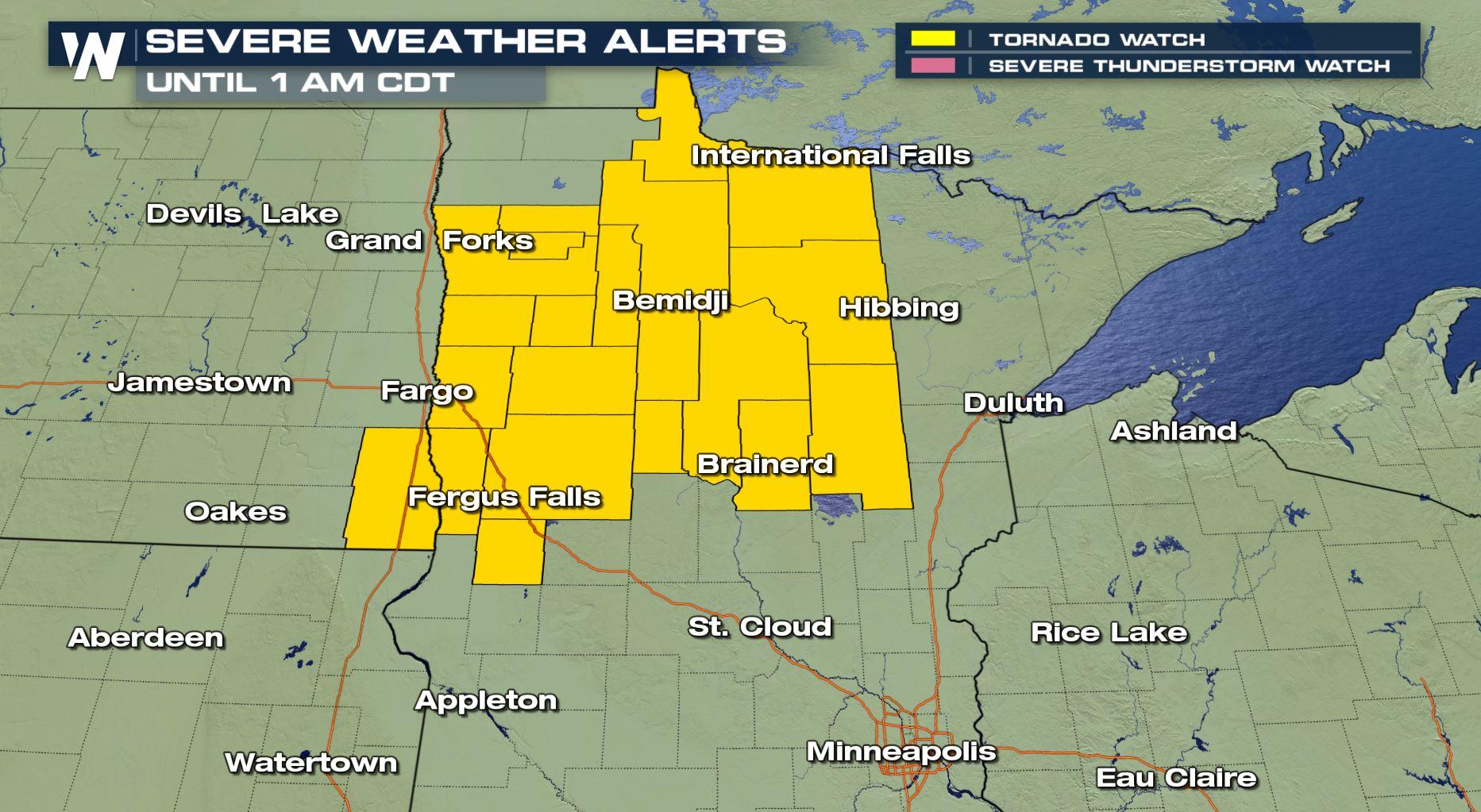
 A tornado watch has been issued until 1 a.m. central Thursday, July 12 for the potential of tornadoes and severe thunderstorms.
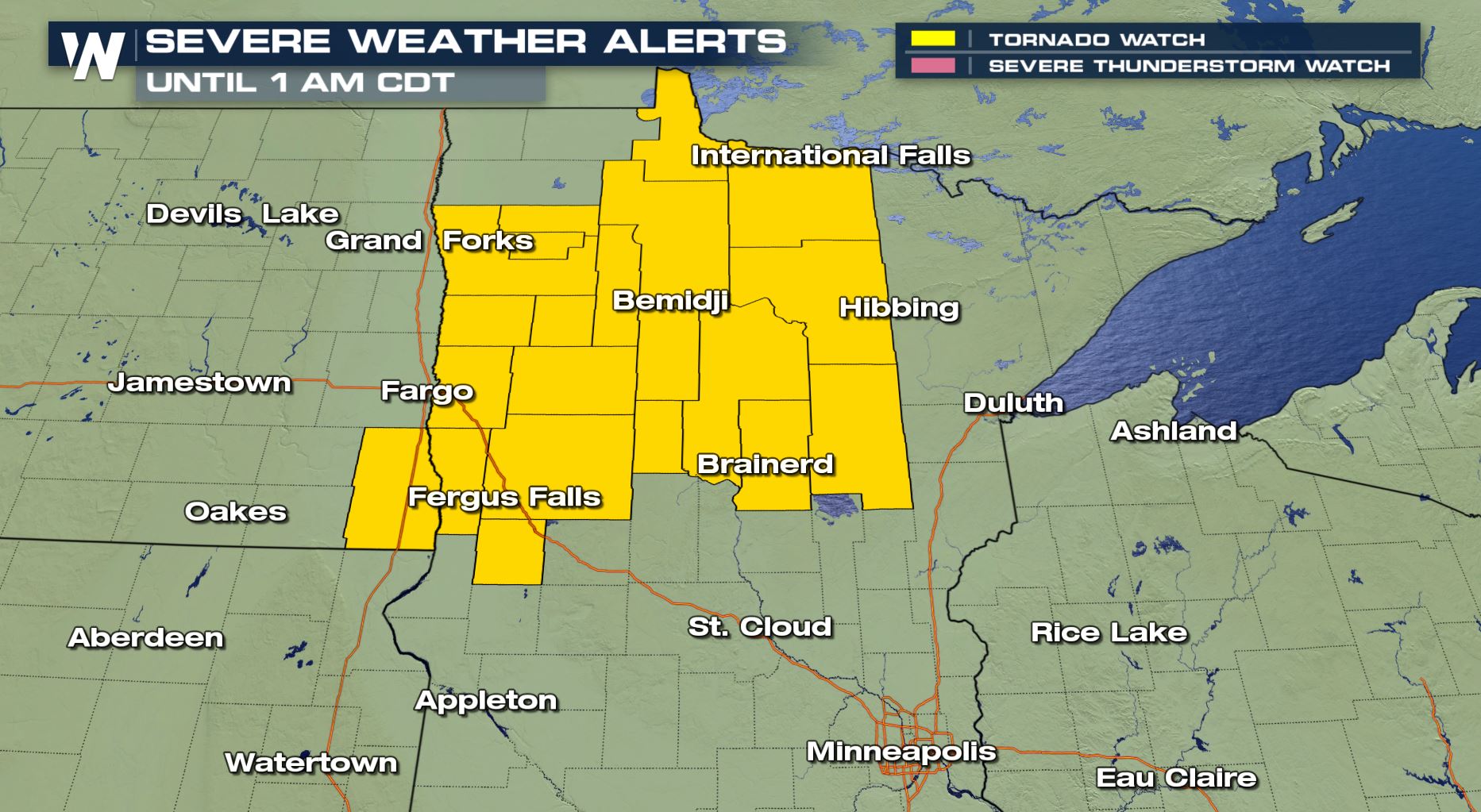
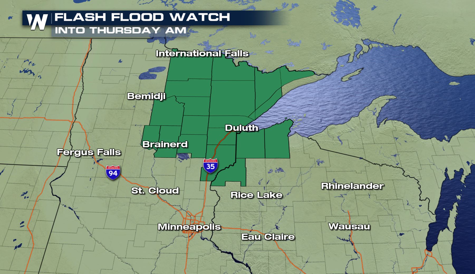 A flash flood watch has been issued for parts of Minnesota and Wisconsin through early Thursday morning, July 12.
A flash flood watch means there is potential for flash flooding in the dark green areas. A watch is issued when conditions may result in hazardous weather within the next several hours. When a warning is issued, that's when you want to take action! In this case, it means avoid driving through flooded roads and watch for areas of quickly-rising water.
A flash flood watch has been issued for parts of Minnesota and Wisconsin through early Thursday morning, July 12.
A flash flood watch means there is potential for flash flooding in the dark green areas. A watch is issued when conditions may result in hazardous weather within the next several hours. When a warning is issued, that's when you want to take action! In this case, it means avoid driving through flooded roads and watch for areas of quickly-rising water.
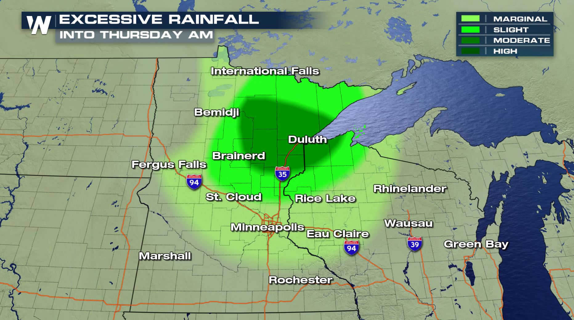 The risk of excessive rainfall overnight Wednesday into Thursday, July 11-12
Wednesday afternoon, the Weather Prediction Center added a 'moderate' risk of excessive rainfall for the greater Duluth, MN area. That means flooding is more likely in the dark shaded area.
The risk of excessive rainfall overnight Wednesday into Thursday, July 11-12
Wednesday afternoon, the Weather Prediction Center added a 'moderate' risk of excessive rainfall for the greater Duluth, MN area. That means flooding is more likely in the dark shaded area.
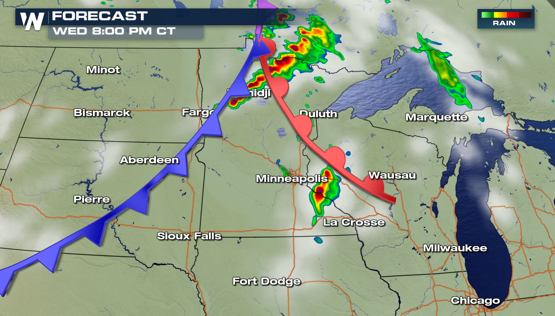 The simulated forecast showing rainfall (greens, yellows) and thunderstorms (oranges, reds) around 8 p.m. central Wednesday, July 11
A cold front will be sweeping east through the Upper Midwest, helping to lift thunderstorms up and grow them to mature, strong heights.
The simulated forecast showing rainfall (greens, yellows) and thunderstorms (oranges, reds) around 8 p.m. central Wednesday, July 11
A cold front will be sweeping east through the Upper Midwest, helping to lift thunderstorms up and grow them to mature, strong heights.
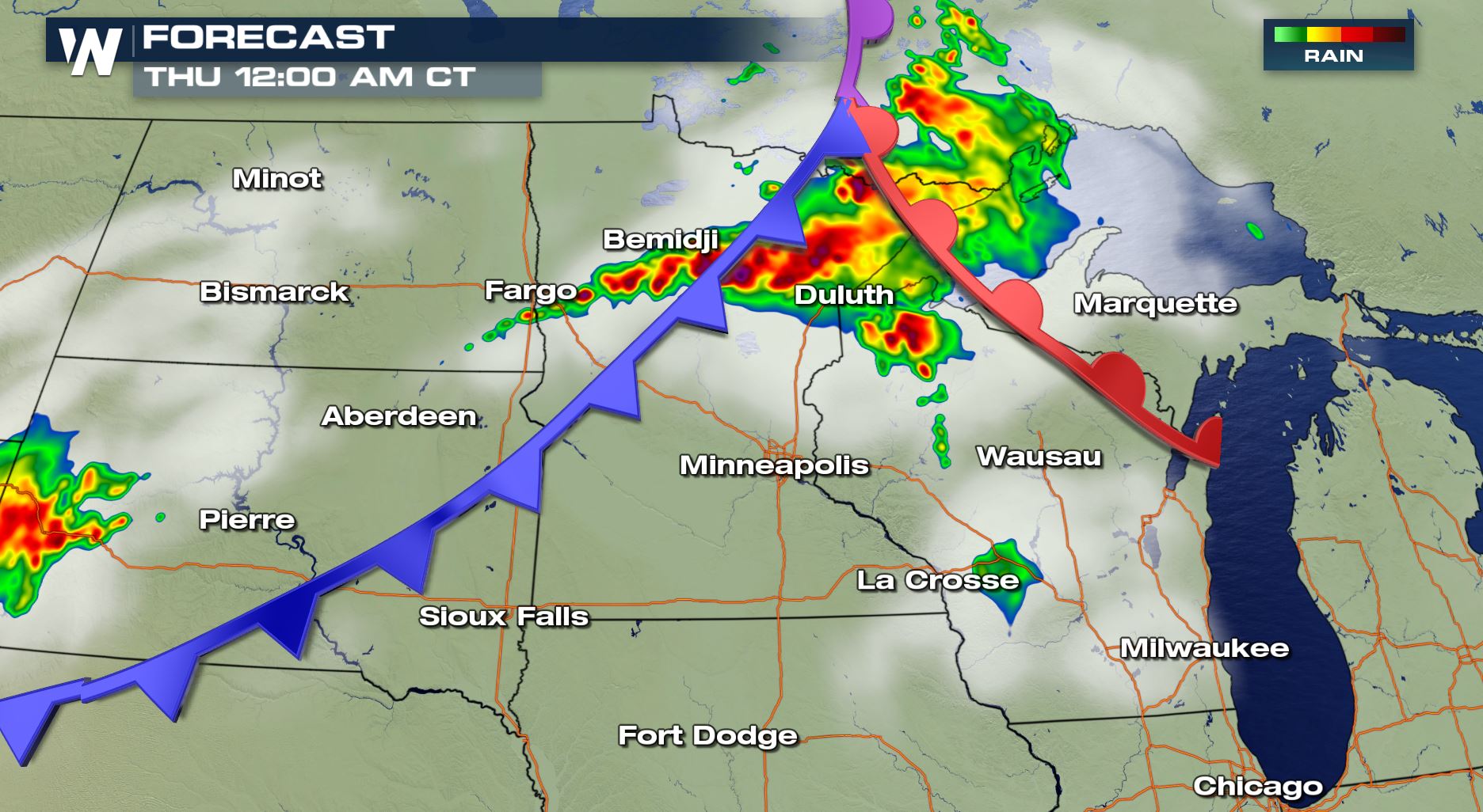 The simulated forecast showing rainfall (greens, yellows) and thunderstorms (oranges, reds) around 12 a.m. central Thursday, July 12
The thunderstorms will likely transform into a line of repeated storms, raising that concern about flooding and flash flooding overnight.
The simulated forecast showing rainfall (greens, yellows) and thunderstorms (oranges, reds) around 12 a.m. central Thursday, July 12
The thunderstorms will likely transform into a line of repeated storms, raising that concern about flooding and flash flooding overnight.
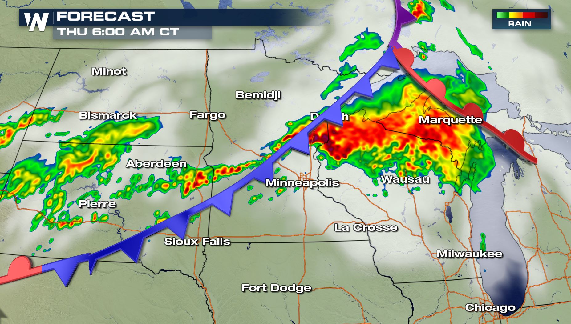 The simulated forecast showing rainfall (greens, yellows) and thunderstorms (oranges, reds) around 6 a.m. central Thursday, July 12
It may even be a wet and stormy morning commute for parts of the Upper Midwest Thursday. *Be especially careful of flooding overnight when the darkness makes it tougher to see high water!*
For WeatherNation, Meteorologist Steve Glazier
The simulated forecast showing rainfall (greens, yellows) and thunderstorms (oranges, reds) around 6 a.m. central Thursday, July 12
It may even be a wet and stormy morning commute for parts of the Upper Midwest Thursday. *Be especially careful of flooding overnight when the darkness makes it tougher to see high water!*
For WeatherNation, Meteorologist Steve Glazier
A tornado watch has been issued until 1 a.m. central Thursday, July 12 for the potential of tornadoes and severe thunderstorms.
A flash flood watch has been issued for parts of Minnesota and Wisconsin through early Thursday morning, July 12.
A flash flood watch means there is potential for flash flooding in the dark green areas. A watch is issued when conditions may result in hazardous weather within the next several hours. When a warning is issued, that's when you want to take action! In this case, it means avoid driving through flooded roads and watch for areas of quickly-rising water.
The risk of excessive rainfall overnight Wednesday into Thursday, July 11-12
Wednesday afternoon, the Weather Prediction Center added a 'moderate' risk of excessive rainfall for the greater Duluth, MN area. That means flooding is more likely in the dark shaded area.
The simulated forecast showing rainfall (greens, yellows) and thunderstorms (oranges, reds) around 8 p.m. central Wednesday, July 11
A cold front will be sweeping east through the Upper Midwest, helping to lift thunderstorms up and grow them to mature, strong heights.
The simulated forecast showing rainfall (greens, yellows) and thunderstorms (oranges, reds) around 12 a.m. central Thursday, July 12
The thunderstorms will likely transform into a line of repeated storms, raising that concern about flooding and flash flooding overnight.
The simulated forecast showing rainfall (greens, yellows) and thunderstorms (oranges, reds) around 6 a.m. central Thursday, July 12
It may even be a wet and stormy morning commute for parts of the Upper Midwest Thursday. *Be especially careful of flooding overnight when the darkness makes it tougher to see high water!*
For WeatherNation, Meteorologist Steve GlazierAll Weather News
More
Fronts Continue To Spark Severe Weather Across the Plains
A cold front that brought record lows to the
18 Jul 2025 10:40 PM

Extreme Heat Impacts for the East Coast & South
Extreme heat continues to impact several area
18 Jul 2025 10:05 PM

Flooding Threat Remains Elevated in the East
A cold front pushing through the Eastern Seab
18 Jul 2025 9:10 PM

EF-2 Firenado from the Deer Creek Fire in Utah
A fire tornado was spotted near La Sal, Utah
18 Jul 2025 7:30 AM

Tropical System Brings Flood Risk to the Central Gulf
Time has run out for notable tropical develop
18 Jul 2025 3:05 AM

Heavy Rain, Flooding Threat Returns to Florida
Keep the rain boots handy in Florida - heavy
13 Jul 2025 12:50 PM

Severe Storm Risk Pushes into the Great Lakes, Ohio Valley
Friday was another busy day with severe weath
12 Jul 2025 8:00 PM