Severe Storms, Tornadoes Lash the Southeast

Top Stories
20 Apr 2020 12:02 PM
Another round of strong-to-severe thunderstorms rocked the Southeast on Sunday night into Monday morning, leading to widespread power outages, and a deadly EF-4 tornado in Mississippi.
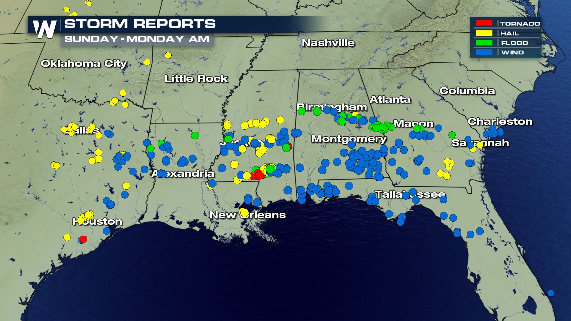
Several strong storms were reported in Mississippi, Alabama, Louisiana, Georgia, Florida and Texas on Sunday afternoon and Sunday night. Damaging winds were the primary threat noted with the majority of the storms, although large hail and tornadoes were observed as well.
Perhaps the most active time period, however, came late on Monday morning as the powerful line of storms moved into central Florida, leading to several tornado reports near Tampa and Orlando. Damaging winds were also observed with these storms.
https://twitter.com/WeatherNation/status/1252278911490125829?s=20
https://twitter.com/WeatherNation/status/1252270044119089154?s=20
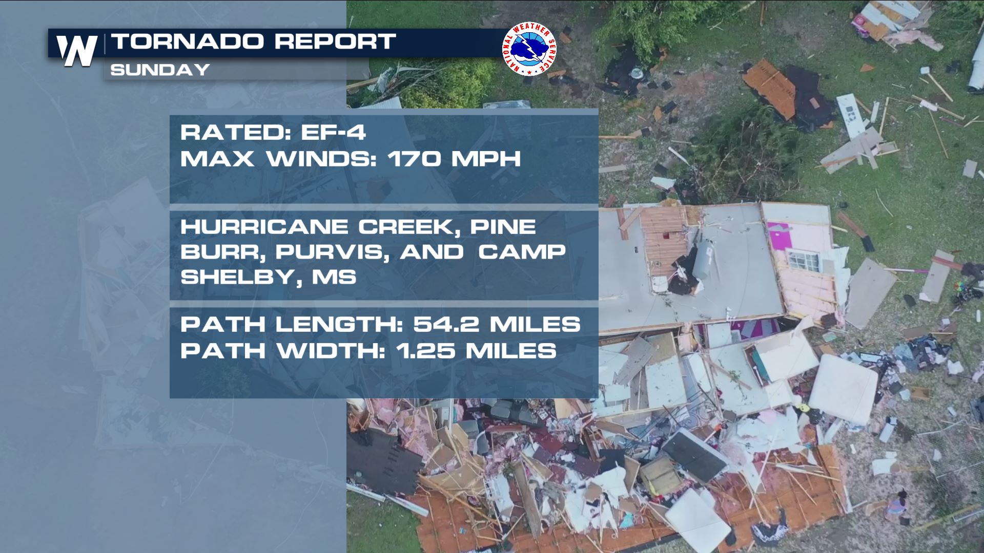
The strongest individual storm from this severe weather outbreak, however, likely was a powerful supercell thunderstorm that moved through southern Mississippi on Sunday. A long-track tornado moved through southern Mississippi on Sunday night, leaving behind a wide path of damage. Here's a look at some of the images in the aftermath from the likely tornado:
https://twitter.com/WeatherNation/status/1252235577002356741?s=20
https://twitter.com/WeatherNation/status/1252266022221910016?s=20
The National Weather Service office in Jackson, Mississippi was out surveying the damage from the tornado in southern Mississippi on Monday. The Jackson office confirmed that a long-track,, EF-4 tornado did indeed touch down on Sunday evening, traveling 50 continuous miles over five southern Mississippi counties.
The tornado has estimated maximum winds of 170 mph, according to NWS Jackson.
 In all, at least 12 tornadoes had been reported, as of Monday afternoon. That included an EF-1 tornado just outside of New Orleans late on Sunday night, according to the National Weather Service office in New Orleans.
 More severe weather is on tap for Tuesday and Wednesday, and some of those storms could impact this same region by Wednesday or Thursday. For more on the severe weather forecast, meteorologist Mace Michaels has more here.
Stay with WeatherNation for the latest on the Sunday and Monday storms, and for your latest forecast.
More severe weather is on tap for Tuesday and Wednesday, and some of those storms could impact this same region by Wednesday or Thursday. For more on the severe weather forecast, meteorologist Mace Michaels has more here.
Stay with WeatherNation for the latest on the Sunday and Monday storms, and for your latest forecast.
In all, at least 12 tornadoes had been reported, as of Monday afternoon. That included an EF-1 tornado just outside of New Orleans late on Sunday night, according to the National Weather Service office in New Orleans.
More severe weather is on tap for Tuesday and Wednesday, and some of those storms could impact this same region by Wednesday or Thursday. For more on the severe weather forecast, meteorologist Mace Michaels has more here.
Stay with WeatherNation for the latest on the Sunday and Monday storms, and for your latest forecast.All Weather News
More
Wildfire Outbreak in the Pacific Northwest
SPOKANE, WA - On Saturday, August 1st, the Ol
3 Aug 2026 1:55 AM

More Storms for the East Through Monday
A low-pressure system that moved through the
3 Aug 2026 1:50 AM


After Reaching Category 5, Genevieve Weakens in the Pacific
PacificGenevieve formed last Friday south of
3 Aug 2026 12:30 AM

Flooding, Severe Storms Target the Midwest Again
After an active week of storms across the nor
1 Aug 2026 1:40 AM

Flooding Risk Increases as Heavy Rain Targets the Tri-State Area
Tuesday, heavy rainfall moved across the Nort
30 Jul 2026 12:25 AM

Severe Weather: Energy From the Midwest Now in the Southeast
UPPER MIDWEST - Through Monday, dangerous tor
29 Jul 2026 10:30 PM