Severe Thunderstorm Watch Issued for Western Plains
Top Stories
11 May 2018 2:45 PM
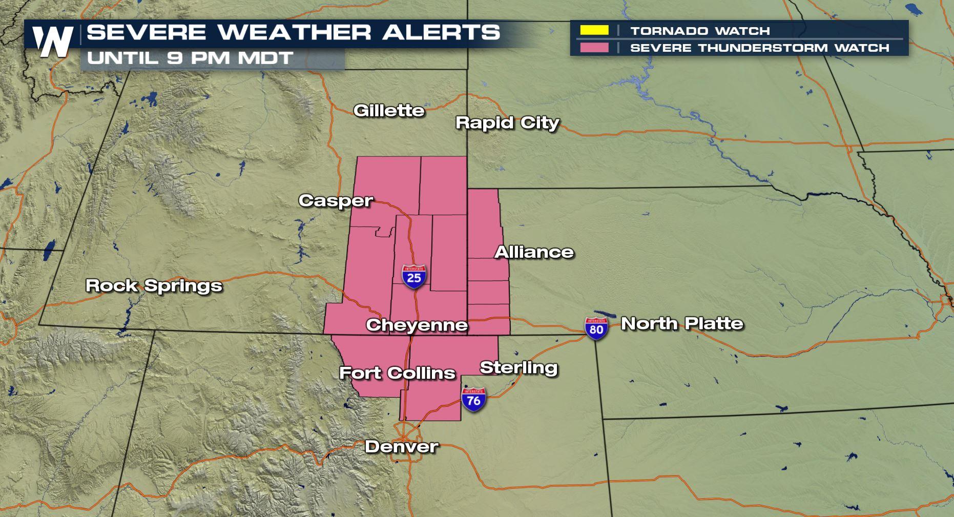
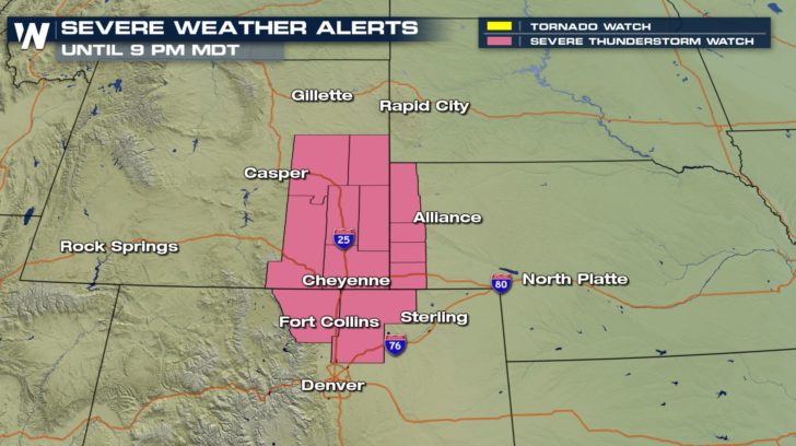
Folks in the Casper, Wyoming to Fort Collins, Colorado area need to watch the weather closely this afternoon and evening because a few severe thunderstorms are expected.
 *Severe thunderstorm watch valid for Friday, May 11.*
We are most concerned about big hail and big wind today.
https://twitter.com/WeatherNation/status/995031727134265344
When the watch was originally issued by the Storm Prediction Center, it covered a population of more than 800,000 people. Those in the watch area need to keep an eye to the sky, keep an ear out for thunder, and adhere to instructions within weather alerts!
*Severe thunderstorm watch valid for Friday, May 11.*
We are most concerned about big hail and big wind today.
https://twitter.com/WeatherNation/status/995031727134265344
When the watch was originally issued by the Storm Prediction Center, it covered a population of more than 800,000 people. Those in the watch area need to keep an eye to the sky, keep an ear out for thunder, and adhere to instructions within weather alerts!
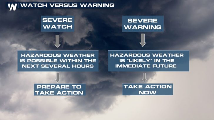 ^^Some good take-home-info between a weather watch and warning^^
This is just one of a couple of areas with the potential of severe weather today.
^^Some good take-home-info between a weather watch and warning^^
This is just one of a couple of areas with the potential of severe weather today.
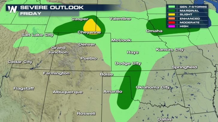 Severe weather outlook for Friday, May 11 where dark green shows a marginal risk of severe weather and yellow means a slight risk (higher than marginal).
Marginal Risk = Isolated severe thunderstorms are expected, however limited in coverage and/or duration
Slight Risk = Scattered severe thunderstorms are expected, some more intense and longer-lasting
Severe weather outlook for Friday, May 11 where dark green shows a marginal risk of severe weather and yellow means a slight risk (higher than marginal).
Marginal Risk = Isolated severe thunderstorms are expected, however limited in coverage and/or duration
Slight Risk = Scattered severe thunderstorms are expected, some more intense and longer-lasting
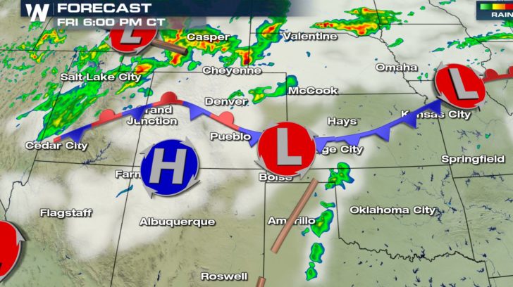 The forecast radar (colors) and clouds (white) for 6 p.m. central and 5 p.m. mountain time Friday, May 11
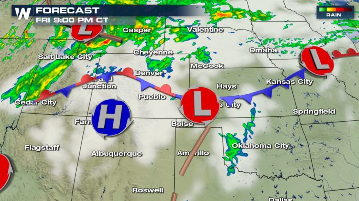 The forecast radar and clouds for the rest of today shows these slow-moving thunderstorms (mainly yellow and red here) moving to the east-northeast. Notice the yellow and reds aren't widespread, meaning these thunderstorms will be here and there, not everywhere.
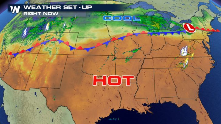 The thunderstorms are popping up along a long boundary separating hot and cool air. Record heat is likely across much of the South, while winter storm warnings are in effect for parts of Wyoming!
For WeatherNation, Meteorologist Steve Glazier
The thunderstorms are popping up along a long boundary separating hot and cool air. Record heat is likely across much of the South, while winter storm warnings are in effect for parts of Wyoming!
For WeatherNation, Meteorologist Steve Glazier
*Severe thunderstorm watch valid for Friday, May 11.*
We are most concerned about big hail and big wind today.
https://twitter.com/WeatherNation/status/995031727134265344
When the watch was originally issued by the Storm Prediction Center, it covered a population of more than 800,000 people. Those in the watch area need to keep an eye to the sky, keep an ear out for thunder, and adhere to instructions within weather alerts!
^^Some good take-home-info between a weather watch and warning^^
This is just one of a couple of areas with the potential of severe weather today.
Severe weather outlook for Friday, May 11 where dark green shows a marginal risk of severe weather and yellow means a slight risk (higher than marginal).
Marginal Risk = Isolated severe thunderstorms are expected, however limited in coverage and/or duration
Slight Risk = Scattered severe thunderstorms are expected, some more intense and longer-lasting
The forecast radar (colors) and clouds (white) for 6 p.m. central and 5 p.m. mountain time Friday, May 11
The forecast radar and clouds for the rest of today shows these slow-moving thunderstorms (mainly yellow and red here) moving to the east-northeast. Notice the yellow and reds aren't widespread, meaning these thunderstorms will be here and there, not everywhere.
The thunderstorms are popping up along a long boundary separating hot and cool air. Record heat is likely across much of the South, while winter storm warnings are in effect for parts of Wyoming!
For WeatherNation, Meteorologist Steve GlazierAll Weather News
More
Fronts Continue To Spark Severe Weather Across the Plains
A cold front that brought record lows to the
18 Jul 2025 10:40 PM

Extreme Heat Impacts for the East Coast & South
Extreme heat continues to impact several area
18 Jul 2025 10:05 PM

Flooding Threat Remains Elevated in the East
A cold front pushing through the Eastern Seab
18 Jul 2025 9:10 PM

EF-2 Firenado from the Deer Creek Fire in Utah
A fire tornado was spotted near La Sal, Utah
18 Jul 2025 7:30 AM

Tropical System Brings Flood Risk to the Central Gulf
Time has run out for notable tropical develop
18 Jul 2025 3:05 AM

Heavy Rain, Flooding Threat Returns to Florida
Keep the rain boots handy in Florida - heavy
13 Jul 2025 12:50 PM

Severe Storm Risk Pushes into the Great Lakes, Ohio Valley
Friday was another busy day with severe weath
12 Jul 2025 8:00 PM