Severe Thunderstorm Watches Issued Thursday
Top Stories
12 Jul 2018 4:49 PM
Multiple severe thunderstorms are expected through the afternoon, evening and possibly overnight Thursday to Friday.
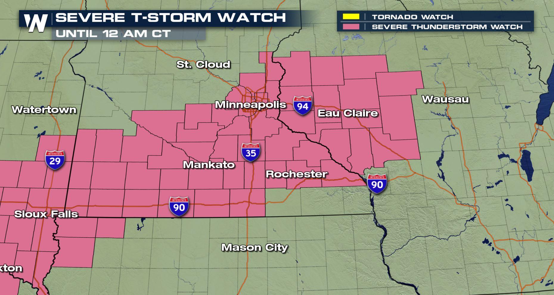
 A severe thunderstorm watch was issued until midnight Friday, July 13 for these shaded areas.
Parts of Minnesota and Wisconsin will get thunderstorms capable of wind gusts up to 70 miles per hour, hail up to 2 inches in diameter, and torrential downpours. Thunderstorms will move along a cold front that separates dangerously-hot air from slightly cooler, more comfortable air across the High Plains.
A severe thunderstorm watch was issued until midnight Friday, July 13 for these shaded areas.
Parts of Minnesota and Wisconsin will get thunderstorms capable of wind gusts up to 70 miles per hour, hail up to 2 inches in diameter, and torrential downpours. Thunderstorms will move along a cold front that separates dangerously-hot air from slightly cooler, more comfortable air across the High Plains.
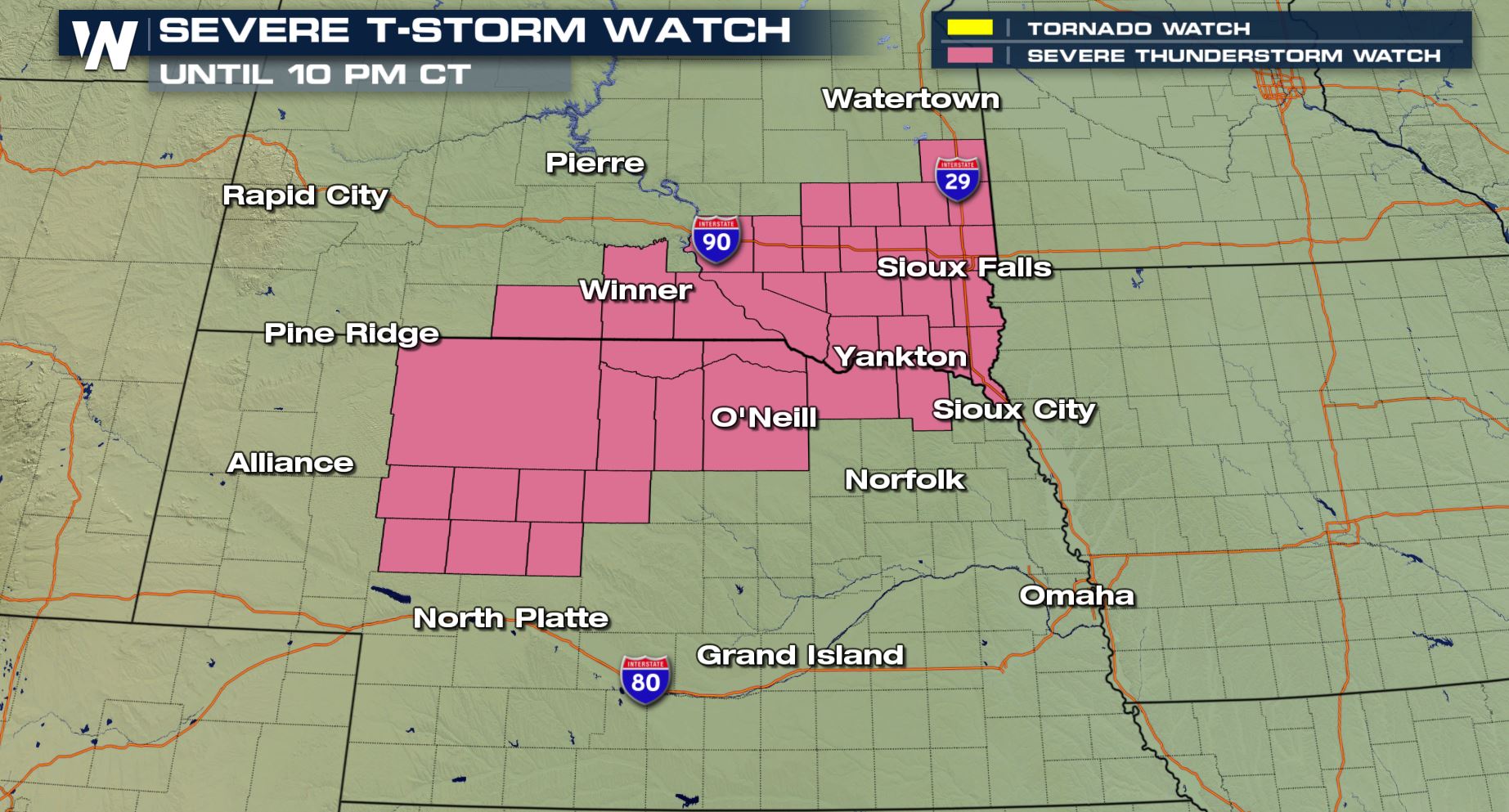 A severe thunderstorm watch was issued until 10 p.m. Thursday, July 12 for parts of Nebraska and South Dakota.
The primary weather hazards in parts of Nebraska and South Dakota will be damaging wind gusts up to 70 miles per hour and hail up to 1 inch thick. These thunderstorms are also moving along a sluggish weather front.
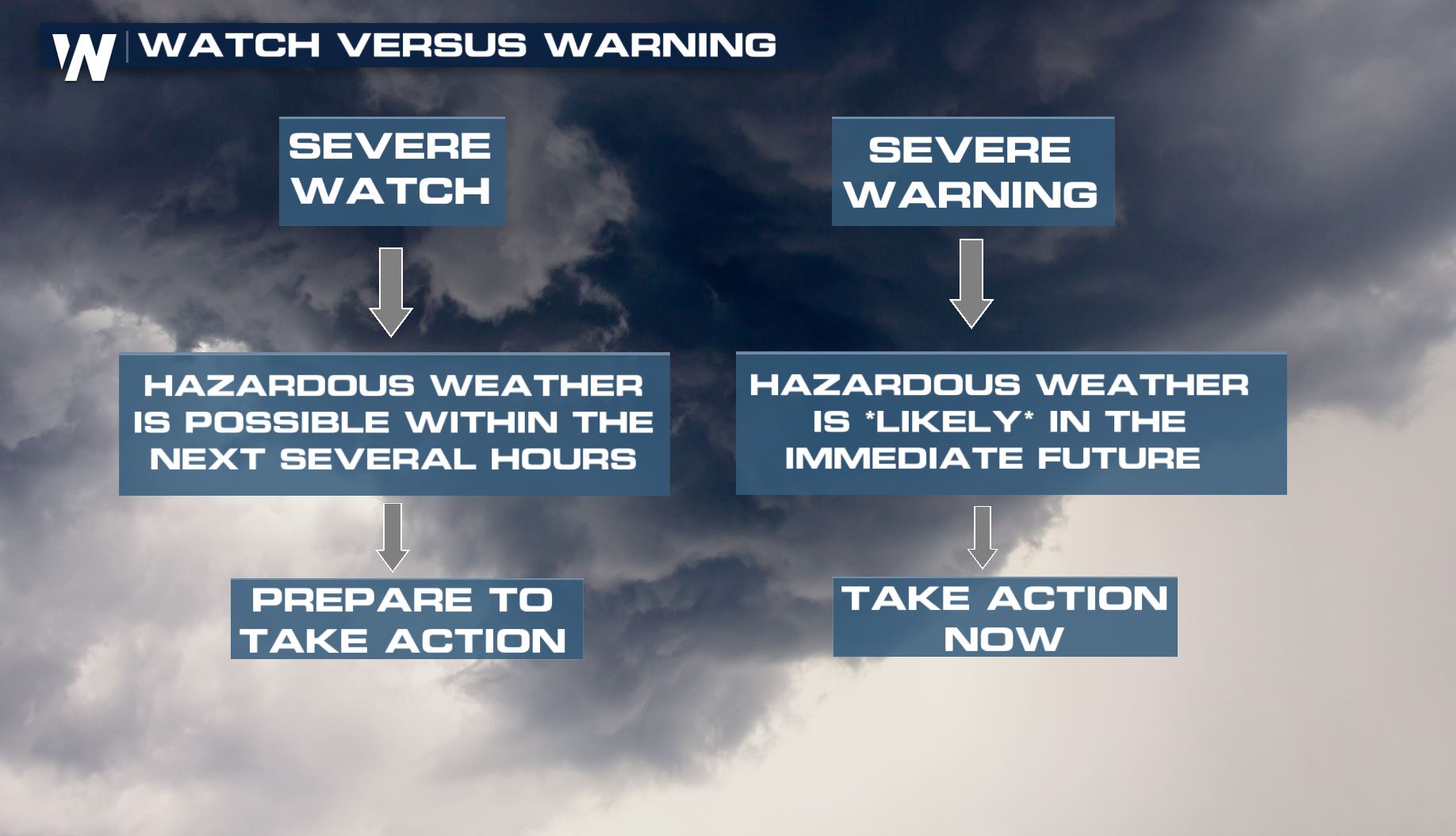
Remember, a severe thunderstorm watch means conditions are favorable for severe thunderstorms. Folks in these areas should be on the lookout for threatening weather conditions and listen for additional statements and/or warnings.
A severe thunderstorm watch was issued until 10 p.m. Thursday, July 12 for parts of Nebraska and South Dakota.
The primary weather hazards in parts of Nebraska and South Dakota will be damaging wind gusts up to 70 miles per hour and hail up to 1 inch thick. These thunderstorms are also moving along a sluggish weather front.
Remember, a severe thunderstorm watch means conditions are favorable for severe thunderstorms. Folks in these areas should be on the lookout for threatening weather conditions and listen for additional statements and/or warnings.
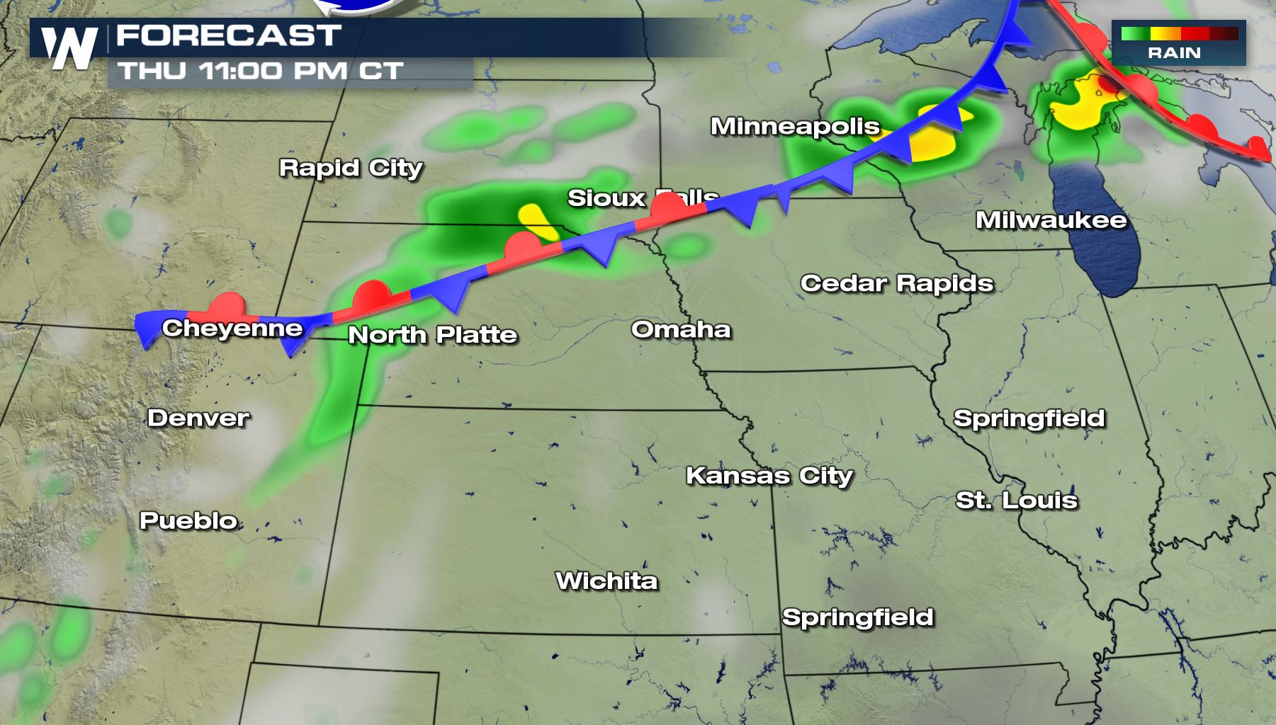 A snapshot of the surface weather map late Thursday, July 12 where green shows the projected rain/thunderstorm activity.
Thunderstorms will move to the east-northeast between 20 and 35 miles per hour. Keep an eye on the western and southwestern sky for incoming storms. The storms will also cause flash flooding in areas of heaviest activity. Remember to never drive through flooded roads!
We have a complete update on Thursday's severe weather outlook from Meteorologist Patrick Crawford here.
For WeatherNation, Meteorologist Steve Glazier
A snapshot of the surface weather map late Thursday, July 12 where green shows the projected rain/thunderstorm activity.
Thunderstorms will move to the east-northeast between 20 and 35 miles per hour. Keep an eye on the western and southwestern sky for incoming storms. The storms will also cause flash flooding in areas of heaviest activity. Remember to never drive through flooded roads!
We have a complete update on Thursday's severe weather outlook from Meteorologist Patrick Crawford here.
For WeatherNation, Meteorologist Steve Glazier
A severe thunderstorm watch was issued until midnight Friday, July 13 for these shaded areas.
Parts of Minnesota and Wisconsin will get thunderstorms capable of wind gusts up to 70 miles per hour, hail up to 2 inches in diameter, and torrential downpours. Thunderstorms will move along a cold front that separates dangerously-hot air from slightly cooler, more comfortable air across the High Plains.
A severe thunderstorm watch was issued until 10 p.m. Thursday, July 12 for parts of Nebraska and South Dakota.
The primary weather hazards in parts of Nebraska and South Dakota will be damaging wind gusts up to 70 miles per hour and hail up to 1 inch thick. These thunderstorms are also moving along a sluggish weather front.
Remember, a severe thunderstorm watch means conditions are favorable for severe thunderstorms. Folks in these areas should be on the lookout for threatening weather conditions and listen for additional statements and/or warnings.
A snapshot of the surface weather map late Thursday, July 12 where green shows the projected rain/thunderstorm activity.
Thunderstorms will move to the east-northeast between 20 and 35 miles per hour. Keep an eye on the western and southwestern sky for incoming storms. The storms will also cause flash flooding in areas of heaviest activity. Remember to never drive through flooded roads!
We have a complete update on Thursday's severe weather outlook from Meteorologist Patrick Crawford here.
For WeatherNation, Meteorologist Steve GlazierAll Weather News
More
Heat Wave Grips Central, Western U.S.
Are you over the summer heat yet? SouthwestEx
25 Jul 2026 11:10 AM

Tropics: Fausto Heads to Hawaii; Genevieve Has Formed and Could Become a Major Hurricane
Atlantic BasinBertha has dissipated after mov
25 Jul 2026 11:00 AM

Severe Storms Target the Midwest This Weekend
Extreme heat will be a big story this week ac
25 Jul 2026 11:00 AM

Southeast Flood Risk Lingers Near Stalled Front
A stalled boundary over the Southeast will ke
25 Jul 2026 10:55 AM

Fire Weather Continues This Weekend
Conditions have been really dry out west. We'
25 Jul 2026 10:50 AM

Another Round of Storms Targets the Northeast
Tuesday brought severe weather again across p
23 Jul 2026 1:15 AM

Another Round of Severe Weather for the Upper Midwest and Great Lakes
The upper-level low train continues to keep t
21 Jul 2026 1:45 AM