Severe Thunderstorms Possible in the Plains

Special Stories
1 Apr 2020 9:29 AM
The North and Central Great Plains have the potential for severe thunderstorms, mainly in the afternoons, on Wednesday and Thursday.
A large, slow moving trough in the upper-levels of the atmosphere over Western Canada will create strong wind shear over the Dakotas and Northern Nebraska by Wednesday afternoon, as a cold front moves southeast at the surface. This could lead to a few high-based thunderstorms over parts of Nebraska and South Dakota Wednesday afternoon, capable of producing large hail and severe wind gusts.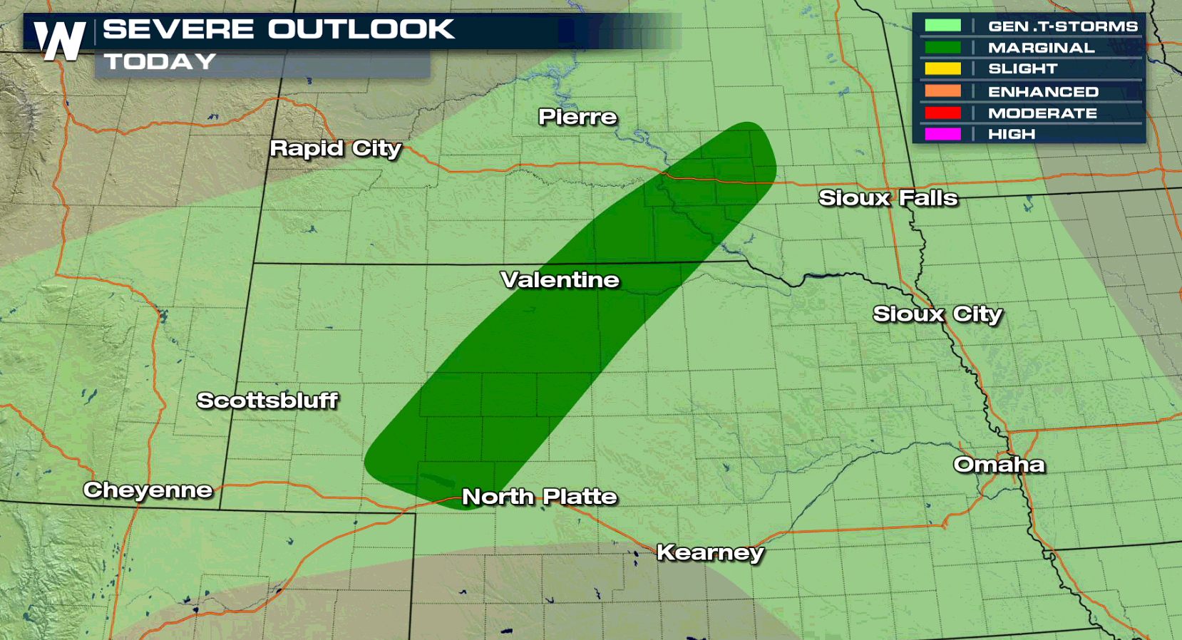 The Storm Prediction Center has issued a marginal risk for the areas in dark green. Thankfully, the threat for severe storms is not expected to last long past sunset, due to the front undercutting storms and improving stability in the lower levels.
On Thursday, the threat for severe storms shifts south into Kansas. The marginal risk issued by the Storm Prediction Center includes the towns of Salina, Hutchinson, and Great Bend.
The Storm Prediction Center has issued a marginal risk for the areas in dark green. Thankfully, the threat for severe storms is not expected to last long past sunset, due to the front undercutting storms and improving stability in the lower levels.
On Thursday, the threat for severe storms shifts south into Kansas. The marginal risk issued by the Storm Prediction Center includes the towns of Salina, Hutchinson, and Great Bend.
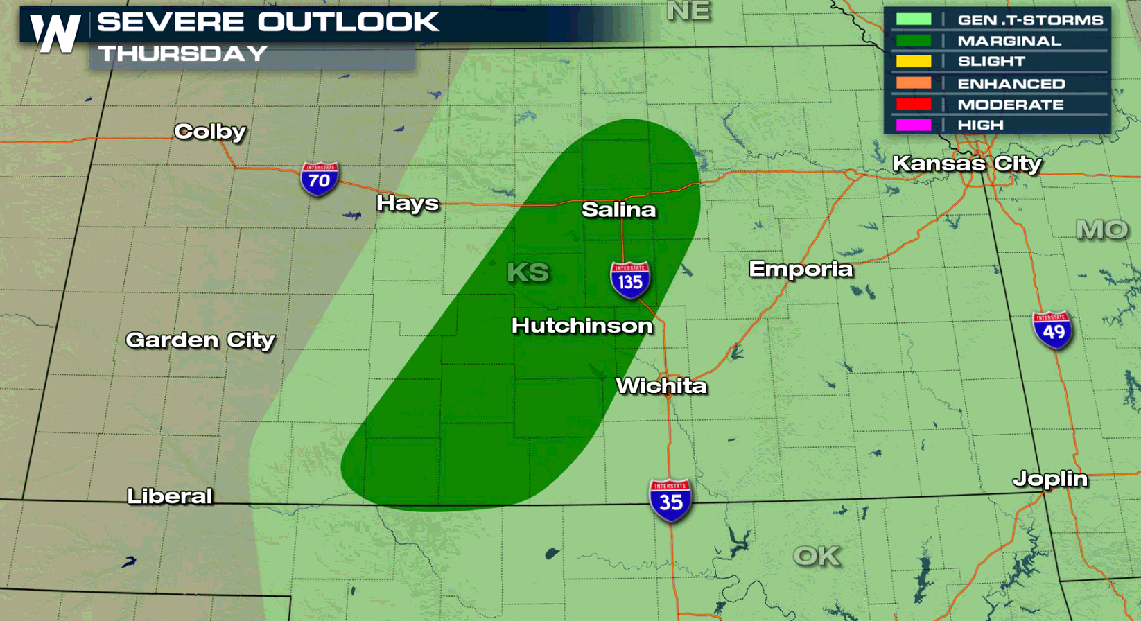 As a cold front continues to move southeast from the Northern Plains, moisture is expected to move north along a dryline stretching from West Texas into the Oklahoma Panhandle. This could lead to a few strong to severe thunderstorms, capable of producing large hail and severe strength winds, across Central Kansas and possibly Northwestern Oklahoma. This activity is also expected to wane quickly during the evening hours.
A few stronger storms will also be possible across Texas on Thursday before the risk for severe storms ramps up in the Lone Star State on Friday.
Stay with WeatherNation for the continuing coverage on the chance for severe storms.
As a cold front continues to move southeast from the Northern Plains, moisture is expected to move north along a dryline stretching from West Texas into the Oklahoma Panhandle. This could lead to a few strong to severe thunderstorms, capable of producing large hail and severe strength winds, across Central Kansas and possibly Northwestern Oklahoma. This activity is also expected to wane quickly during the evening hours.
A few stronger storms will also be possible across Texas on Thursday before the risk for severe storms ramps up in the Lone Star State on Friday.
Stay with WeatherNation for the continuing coverage on the chance for severe storms.
The Storm Prediction Center has issued a marginal risk for the areas in dark green. Thankfully, the threat for severe storms is not expected to last long past sunset, due to the front undercutting storms and improving stability in the lower levels.
On Thursday, the threat for severe storms shifts south into Kansas. The marginal risk issued by the Storm Prediction Center includes the towns of Salina, Hutchinson, and Great Bend.
As a cold front continues to move southeast from the Northern Plains, moisture is expected to move north along a dryline stretching from West Texas into the Oklahoma Panhandle. This could lead to a few strong to severe thunderstorms, capable of producing large hail and severe strength winds, across Central Kansas and possibly Northwestern Oklahoma. This activity is also expected to wane quickly during the evening hours.
A few stronger storms will also be possible across Texas on Thursday before the risk for severe storms ramps up in the Lone Star State on Friday.
Stay with WeatherNation for the continuing coverage on the chance for severe storms.All Weather News
More
Fronts Continue To Spark Severe Weather Across the Plains
A cold front that brought record lows to the
18 Jul 2025 10:40 PM

Extreme Heat Impacts for the East Coast & South
Extreme heat continues to impact several area
18 Jul 2025 10:05 PM

Flooding Threat Remains Elevated in the East
A cold front pushing through the Eastern Seab
18 Jul 2025 9:10 PM

EF-2 Firenado from the Deer Creek Fire in Utah
A fire tornado was spotted near La Sal, Utah
18 Jul 2025 7:30 AM

Tropical System Brings Flood Risk to the Central Gulf
Time has run out for notable tropical develop
18 Jul 2025 3:05 AM

Heavy Rain, Flooding Threat Returns to Florida
Keep the rain boots handy in Florida - heavy
13 Jul 2025 12:50 PM

Severe Storm Risk Pushes into the Great Lakes, Ohio Valley
Friday was another busy day with severe weath
12 Jul 2025 8:00 PM