Severe Weather for the South!

Special Stories
10 Mar 2019 11:35 AM
ACTIVE WEATHER SETUP
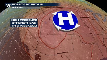
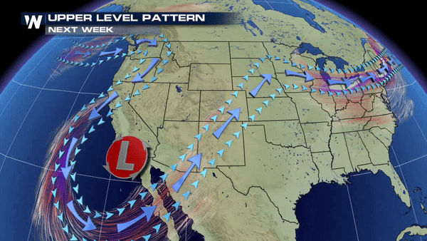 A low pressure system sitting in the southwest will stream in plenty of moisture from the Pacific into areas like New Mexico and Texas over the next few days. This will help fuel up plenty of thunderstorms as we head into our work week.
SEVERE WEATHER RISK
A low pressure system sitting in the southwest will stream in plenty of moisture from the Pacific into areas like New Mexico and Texas over the next few days. This will help fuel up plenty of thunderstorms as we head into our work week.
SEVERE WEATHER RISK
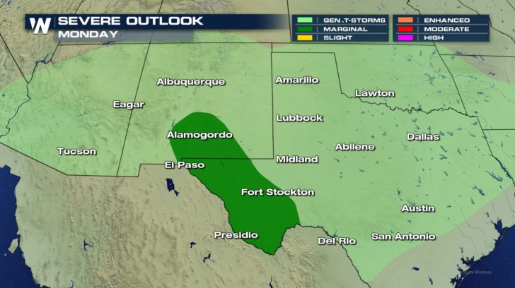
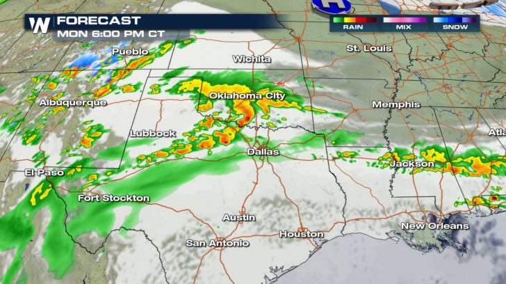
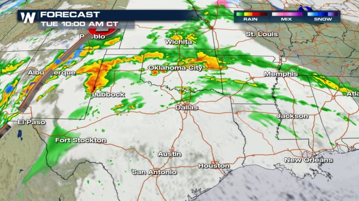
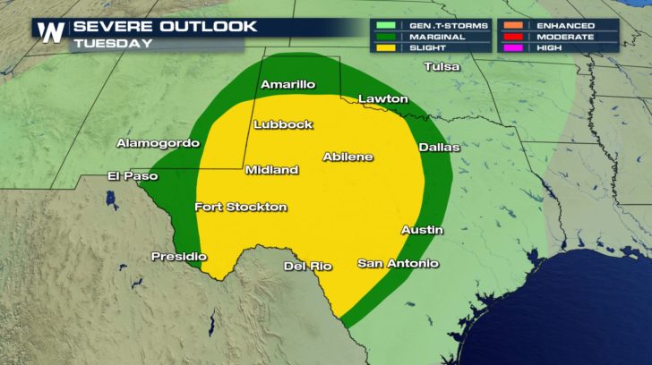 The thunderstorms will ramp up Monday and Tuesday where we have a threat of severe weather. Scattered severe thunderstorms will be possible Tuesday for cities like Lubbock, Abilene, Midland, and Fort Stockton.
FORECAST
The thunderstorms will ramp up Monday and Tuesday where we have a threat of severe weather. Scattered severe thunderstorms will be possible Tuesday for cities like Lubbock, Abilene, Midland, and Fort Stockton.
FORECAST
 PRECIPITATION FORECAST
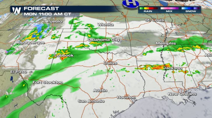
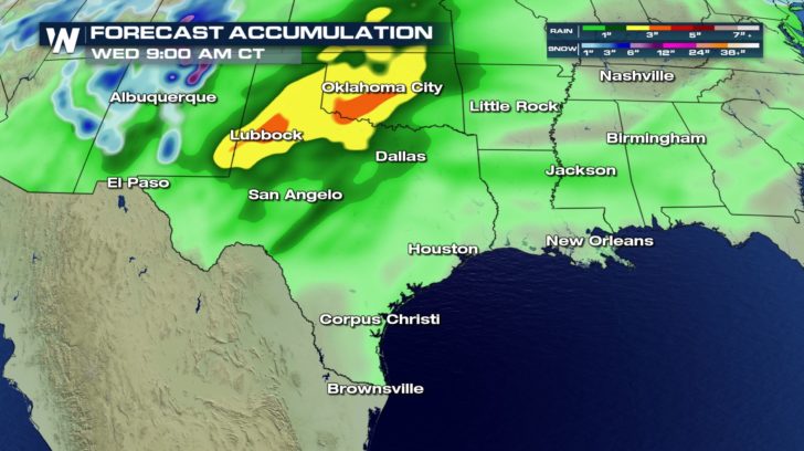 Rain will be quite heavy and consistent over the next several days. Rainfall totals could reach up to 4 inches for northern Texas and Oklahoma. This could potentially lead to flooding, as well. Make sure to stay weather aware over the next few days, and remember, if you see flooding turn around, don't drown.
A low pressure system sitting in the southwest will stream in plenty of moisture from the Pacific into areas like New Mexico and Texas over the next few days. This will help fuel up plenty of thunderstorms as we head into our work week.
SEVERE WEATHER RISK
The thunderstorms will ramp up Monday and Tuesday where we have a threat of severe weather. Scattered severe thunderstorms will be possible Tuesday for cities like Lubbock, Abilene, Midland, and Fort Stockton.
FORECAST
PRECIPITATION FORECAST
Rain will be quite heavy and consistent over the next several days. Rainfall totals could reach up to 4 inches for northern Texas and Oklahoma. This could potentially lead to flooding, as well. Make sure to stay weather aware over the next few days, and remember, if you see flooding turn around, don't drown.All Weather News
More
Monsoon Moisture Returns to the Southwest, Increasing Storm and Flash Flood Potential
After weeks of hot and mostly dry weather, th
11 Jul 2026 11:15 PM
Extreme Heat For the West & Upper-Midwest
Extreme heat will continue to build across th
11 Jul 2026 11:05 PM

Stalled Boundary Increases Flood Threat into the Weekend
Life-threatening flash flooding developed ove
11 Jul 2026 11:00 PM

Saharan Dust, Excessive Heat Impact the Southeast
Hazy skies will be hovering over portions of
11 Jul 2026 10:20 AM

Another Day of Storms for the Plains & Front Range
Several rounds of severe weather have been ro
11 Jul 2026 1:50 AM

Babylon Fire in UT Surpasses 100,000 Acres, CO Fires Continue to Grow
The Aspen Acres fire continues to burn in Sou
10 Jul 2026 1:40 AM
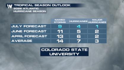
Colorado State University Scales Back 2026 Atlantic Hurricane Season Forecast
Colorado State University researchers have lo
10 Jul 2026 12:20 AM