Severe Weather Threat for Tuesday
Special Stories
8 Apr 2019 11:41 AM
FORECAST
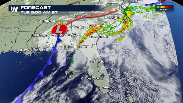 Severe weather has be dominating in the south and southeast over the last couple of days. The severe weather threat does not stop for today, though.
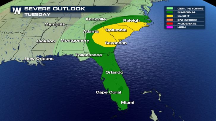
On Tuesday, we will see an increase of severe chances as we head into the afternoon. This severe potential will also linger into our evening hours as the cold front continues to slide off the coast.
A slight chance of severe weather is already in place for North Carolina, South Carolina, and Georgia which means scattered severe thunderstorms will be possible.
RAINFALL FORECAST
Severe weather has be dominating in the south and southeast over the last couple of days. The severe weather threat does not stop for today, though.
On Tuesday, we will see an increase of severe chances as we head into the afternoon. This severe potential will also linger into our evening hours as the cold front continues to slide off the coast.
A slight chance of severe weather is already in place for North Carolina, South Carolina, and Georgia which means scattered severe thunderstorms will be possible.
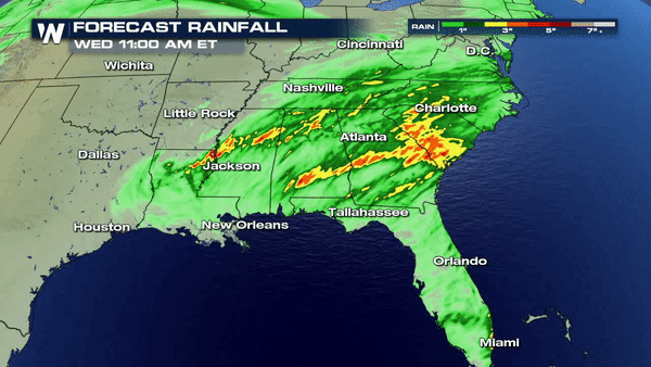
RAINFALL FORECAST
 Rainfall totals will be very high over the next 36 hours. Areas in the Carolinas to Mississippi could receive an additional 4 inches of rain. This means flooding might also be a possibility. Stay safe!
Severe weather has be dominating in the south and southeast over the last couple of days. The severe weather threat does not stop for today, though.
On Tuesday, we will see an increase of severe chances as we head into the afternoon. This severe potential will also linger into our evening hours as the cold front continues to slide off the coast.
A slight chance of severe weather is already in place for North Carolina, South Carolina, and Georgia which means scattered severe thunderstorms will be possible.
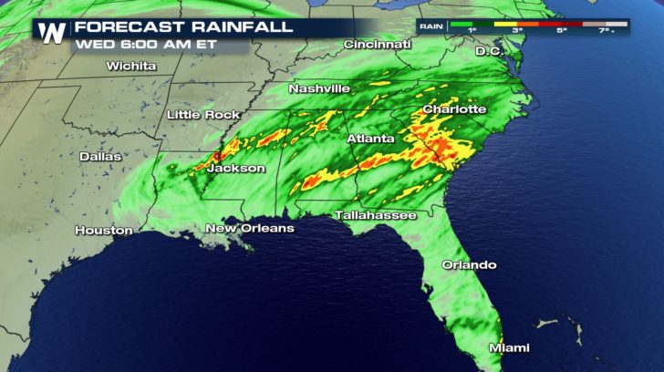
RAINFALL FORECAST
Rainfall totals will be very high over the next 36 hours. Areas in the Carolinas to Mississippi could receive an additional 4 inches of rain. This means flooding might also be a possibility. Stay safe!All Weather News
More
Fronts Continue To Spark Severe Weather Across the Plains
A cold front that brought record lows to the
18 Jul 2025 10:40 PM

Extreme Heat Impacts for the East Coast & South
Extreme heat continues to impact several area
18 Jul 2025 10:05 PM

Flooding Threat Remains Elevated in the East
A cold front pushing through the Eastern Seab
18 Jul 2025 9:10 PM

EF-2 Firenado from the Deer Creek Fire in Utah
A fire tornado was spotted near La Sal, Utah
18 Jul 2025 7:30 AM

Tropical System Brings Flood Risk to the Central Gulf
Time has run out for notable tropical develop
18 Jul 2025 3:05 AM

Heavy Rain, Flooding Threat Returns to Florida
Keep the rain boots handy in Florida - heavy
13 Jul 2025 12:50 PM

Severe Storm Risk Pushes into the Great Lakes, Ohio Valley
Friday was another busy day with severe weath
12 Jul 2025 8:00 PM