Shipping Challenges after Hurricane Florence
Special Stories
25 Sep 2018 8:29 AM
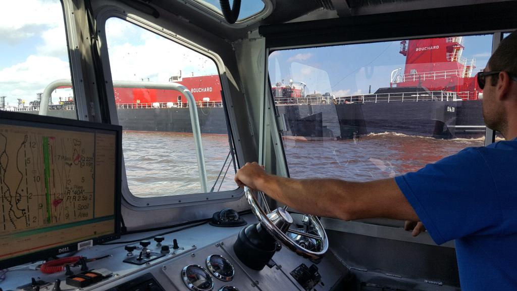
[James Kirkpatrick, team lead of NRT – Fernandina Beach, surveys the Cape Fear River following Hurricane Florence.]
[NOAA] While conducting hydrographic surveys at the request of the U.S. Coast Guard following Hurricane Florence, NOAA’s Office of Coast Survey navigation response teams (NRT) identified hazardous obstructions in the Cape Fear River channel. Since these dangers to navigation will remain in place while the port reopens, NOAA updated its charts with the new hazards and distributed them to the port, Coast Guard, and key stakeholders. The time from the survey to the publication of the chart was less than 24 hours, an unprecedented accomplishment for Coast Survey.
“NOAA has streamlined all phases of our ping-to-chart process over the past 10 years,” remarked Rear Admiral Shepard Smith, the director of NOAA’s Office of Coast Survey, “this milestone results from dozens of technology, workflow, and distribution changes that have dramatically improved the level of service to the American public. We would not even have imagined doing this in the paper chart era. The most significant improvements have come in sonar integration, 3D GPS surveying, gridded bathymetry workflows, database-driven GIS-based cartography, and free internet chart distribution.”
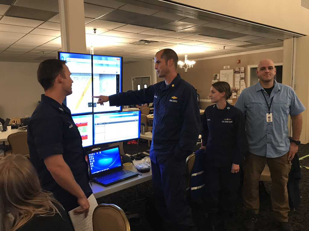 [Lt. Cmdr. Wartick providing a brief-out on NOAA survey work and data analysis as part of the Coast Guard Maritime Transportation System Recovery Unit report to Coast Guard leadership.]
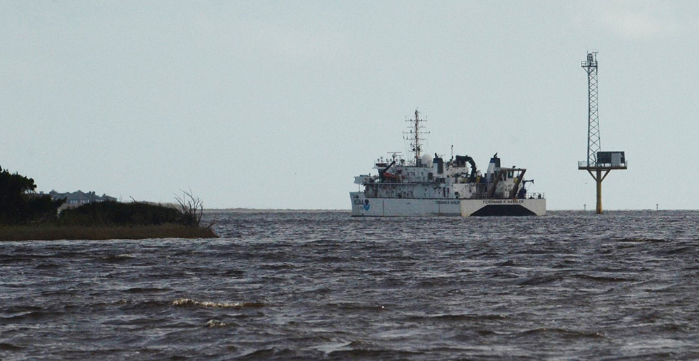 [NOAA Ship Ferdinand R. Hassler surveys the approaches to Cape Fear River, North Carolina.]
The Port of Wilmington, located 26 miles up the Cape Fear River from the open sea, is a major Southern port that supports container, bulk, breakbulk, and roll-on roll-off operations. The Coast Guard Captain of the Port closed the Port of Wilmington in advance of the hurricane and considered restoring navigation to the port urgent. Commerce coming into the port directly supports the local community with jobs, food, fuel, and other products. The local hospitals and the main water treatment plant were running off generator power with fuel supplies running low.
NOAA’s NRT stationed in Fernandina Beach, Florida, traveled to Wilmington and coordinated with the Army Corps to survey the Cape Fear River. The team collected side scan sonar and multibeam echo sounder data to junction with NOAA Ship Ferdinand R. Hassler‘s survey data of the approaches to Cape Fear River. The team worked around the clock – on the water all day and processing the data overnight – to provide the Coast Guard with the condition surveys of the approach, channel, and critical terminals. The team found four underwater hazards and anticipates more hazards may be found as surveying continues. The surveys allowed a fuel barge to enter Wilmington to re-fuel the local hospital and water facility to keep them running.
[NOAA Ship Ferdinand R. Hassler surveys the approaches to Cape Fear River, North Carolina.]
The Port of Wilmington, located 26 miles up the Cape Fear River from the open sea, is a major Southern port that supports container, bulk, breakbulk, and roll-on roll-off operations. The Coast Guard Captain of the Port closed the Port of Wilmington in advance of the hurricane and considered restoring navigation to the port urgent. Commerce coming into the port directly supports the local community with jobs, food, fuel, and other products. The local hospitals and the main water treatment plant were running off generator power with fuel supplies running low.
NOAA’s NRT stationed in Fernandina Beach, Florida, traveled to Wilmington and coordinated with the Army Corps to survey the Cape Fear River. The team collected side scan sonar and multibeam echo sounder data to junction with NOAA Ship Ferdinand R. Hassler‘s survey data of the approaches to Cape Fear River. The team worked around the clock – on the water all day and processing the data overnight – to provide the Coast Guard with the condition surveys of the approach, channel, and critical terminals. The team found four underwater hazards and anticipates more hazards may be found as surveying continues. The surveys allowed a fuel barge to enter Wilmington to re-fuel the local hospital and water facility to keep them running.
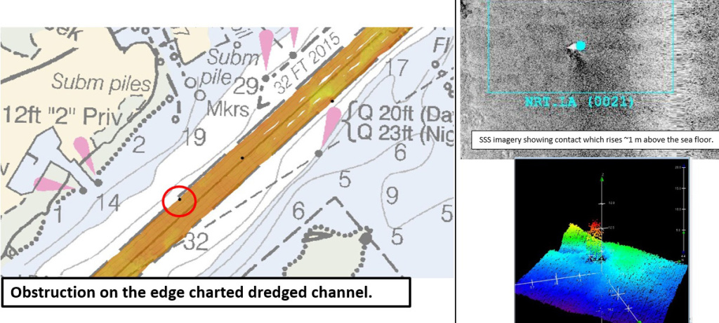 [One of the four objects detected in Cape Fear River by NOAA’s navigation response team and reported to the Coast Guard on September 17. (Note: chartlet not for navigation)]
The Port of Morehead City is located four miles from the Atlantic Ocean and lies within 700 miles of 70% of the U.S. industrial base. NOAA’s NRT stationed in New London, Connecticut, traveled to Coast Guard Station Morehead City to survey the port at the request of the Coast Guard Captain of the Port. The team completed survey work on September 18, processed the data, and delivered their results to the Coast Guard. The team verified no obstructions needed removal prior to reopening the port, supporting the Coast Guard decision to allow their vessels to navigate the waterway.
NOAA’s mobile integrated survey team (MIST) surveyed Murrells Inlet, South Carolina, at the request of the U.S. Coast Guard using their TanB (trailerable aids to navigation boat) vessel. For this response, the MIST equipment included the autonomous surface vehicle, EchoBoat, equipped with side scan sonar and a multibeam echo sounder, and the REMUS 100 autonomous underwater vehicle. After completing work at Murrells Inlet, the team surveyed the Little River Inlet just south of the North Carolina border.
[One of the four objects detected in Cape Fear River by NOAA’s navigation response team and reported to the Coast Guard on September 17. (Note: chartlet not for navigation)]
The Port of Morehead City is located four miles from the Atlantic Ocean and lies within 700 miles of 70% of the U.S. industrial base. NOAA’s NRT stationed in New London, Connecticut, traveled to Coast Guard Station Morehead City to survey the port at the request of the Coast Guard Captain of the Port. The team completed survey work on September 18, processed the data, and delivered their results to the Coast Guard. The team verified no obstructions needed removal prior to reopening the port, supporting the Coast Guard decision to allow their vessels to navigate the waterway.
NOAA’s mobile integrated survey team (MIST) surveyed Murrells Inlet, South Carolina, at the request of the U.S. Coast Guard using their TanB (trailerable aids to navigation boat) vessel. For this response, the MIST equipment included the autonomous surface vehicle, EchoBoat, equipped with side scan sonar and a multibeam echo sounder, and the REMUS 100 autonomous underwater vehicle. After completing work at Murrells Inlet, the team surveyed the Little River Inlet just south of the North Carolina border.
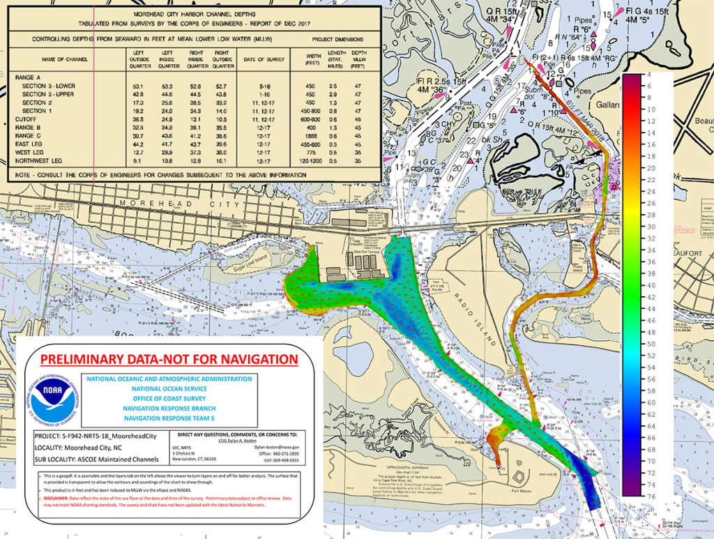 [Multibeam echo sounder data of the Port of Morehead City collected by NOAA’s navigation response team and reported to the Coast Guard on September 18, 2018. (Note: chartlet not for navigation)]
[Lt. Cmdr. Wartick providing a brief-out on NOAA survey work and data analysis as part of the Coast Guard Maritime Transportation System Recovery Unit report to Coast Guard leadership.]
Surveying for underwater hazards in the Carolinas
As Hurricane Florence made landfall as a Category 1 storm on September 14 near Wrightsville Beach on the North Carolina coast, Coast Survey’s navigation managers and response teams were positioned and standing by, ready to conduct hydrographic surveys in the affected ports and waterways. As the storm passed through, requests from the Coast Guard and U.S. Army Corps of Engineers for survey assistance were received. Lt. Cmdr. Ryan Wartick, NOAA’s mid-Atlantic navigation manager, was embedded with the Coast Guard incident command post and Maritime Transportation System Recovery Unit team at Seymour Johnson U.S. Air Force Base in Goldsboro, North Carolina. With local Army Corps personnel affected by the hurricane, the team relied heavily on NOAA field units and their surveys to assist in the decision to reopen the ports of Morehead City and Wilmington.
[NOAA Ship Ferdinand R. Hassler surveys the approaches to Cape Fear River, North Carolina.]
The Port of Wilmington, located 26 miles up the Cape Fear River from the open sea, is a major Southern port that supports container, bulk, breakbulk, and roll-on roll-off operations. The Coast Guard Captain of the Port closed the Port of Wilmington in advance of the hurricane and considered restoring navigation to the port urgent. Commerce coming into the port directly supports the local community with jobs, food, fuel, and other products. The local hospitals and the main water treatment plant were running off generator power with fuel supplies running low.
NOAA’s NRT stationed in Fernandina Beach, Florida, traveled to Wilmington and coordinated with the Army Corps to survey the Cape Fear River. The team collected side scan sonar and multibeam echo sounder data to junction with NOAA Ship Ferdinand R. Hassler‘s survey data of the approaches to Cape Fear River. The team worked around the clock – on the water all day and processing the data overnight – to provide the Coast Guard with the condition surveys of the approach, channel, and critical terminals. The team found four underwater hazards and anticipates more hazards may be found as surveying continues. The surveys allowed a fuel barge to enter Wilmington to re-fuel the local hospital and water facility to keep them running.
[One of the four objects detected in Cape Fear River by NOAA’s navigation response team and reported to the Coast Guard on September 17. (Note: chartlet not for navigation)]
The Port of Morehead City is located four miles from the Atlantic Ocean and lies within 700 miles of 70% of the U.S. industrial base. NOAA’s NRT stationed in New London, Connecticut, traveled to Coast Guard Station Morehead City to survey the port at the request of the Coast Guard Captain of the Port. The team completed survey work on September 18, processed the data, and delivered their results to the Coast Guard. The team verified no obstructions needed removal prior to reopening the port, supporting the Coast Guard decision to allow their vessels to navigate the waterway.
NOAA’s mobile integrated survey team (MIST) surveyed Murrells Inlet, South Carolina, at the request of the U.S. Coast Guard using their TanB (trailerable aids to navigation boat) vessel. For this response, the MIST equipment included the autonomous surface vehicle, EchoBoat, equipped with side scan sonar and a multibeam echo sounder, and the REMUS 100 autonomous underwater vehicle. After completing work at Murrells Inlet, the team surveyed the Little River Inlet just south of the North Carolina border.
[Multibeam echo sounder data of the Port of Morehead City collected by NOAA’s navigation response team and reported to the Coast Guard on September 18, 2018. (Note: chartlet not for navigation)]
Charting underwater hazards to ensure immediate safe navigation
Coast Survey’s John Whiddon and Lance Roddy received the Cape Fear River hazard locations from the response team and registered them with the Nautical Data Branch. Cartographers Darien Watkins and Brian Martinez, added the hazards to the navigational chart and delivered an updated chart to the Coast Guard in under eight hours. This data supported the Coast Guard’s decision to reopen the Port of Wilmington. The updated chart will be released to the public on the afternoon of Thursday, September 20, three days after the hazards were discovered, as part of the regular weekly update cycle so all mariners can be notified as soon as possible.Improving storm surge modeling to support public safety
Coast Survey is more than surveying, charting, and maritime response. The Coast Survey Development Lab provided storm surge modeling expertise to the National Hurricane Center in Miami, Florida, ahead of and following the hurricane. Dr. Sergey V. Vinogradov, storm surge modeling lead, provided visualizations of storm surge simulations using the Hurricane Surge On-demand Forecast System for each forecast cycle of Hurricane Florence. Hindcast simulations were performed following the storm, to validate the model performance. This work contributed to storm surge predictions and inundation information, ultimately supporting public safety. Edited for WeatherNation by Meteorologist Mace MichaelsAll Weather News
More
SW Low Moves East, Brings Flood Threat to the Plains
A powerful low pressure system has been movin
24 Oct 2026 1:10 AM

Hurricane Vance Strengthens In The Pacific
After becoming a hurricane Friday, Vance quic
24 Oct 2026 1:00 AM

Warmer Than Average: Above-Normal Temperatures Across the Central U.S. This Week
WHAT TO EXPECTA ridge of high pressure linger
24 Oct 2026 12:50 AM


Several Fires Break Out in SoCal Last Week Amid Santa Ana Wind Event
Santa Ana winds helped several fires grow qui
19 Oct 2026 1:25 PM

Another Cold Morning Before Things Warm Back Up
Across portions of the Ohio Valley through th
19 Oct 2026 10:15 AM

Severe Risk Diminishing Saturday Morning for the Northeast
Severe Storm PotentialSevere risk is decreasi
16 Oct 2026 10:20 AM