Sierra Nevada Snow Pack: What a Difference a Year Makes
Special Stories
5 Mar 2018 8:03 PM
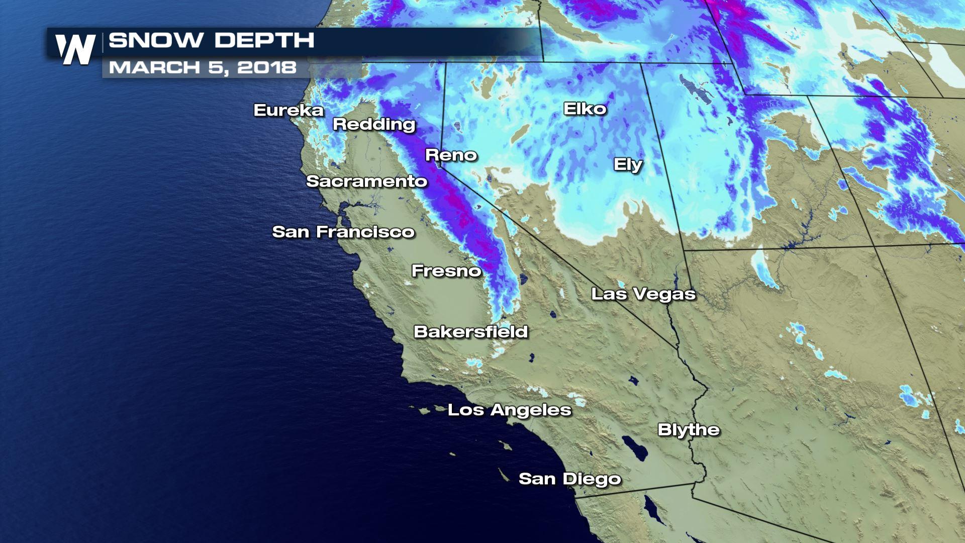
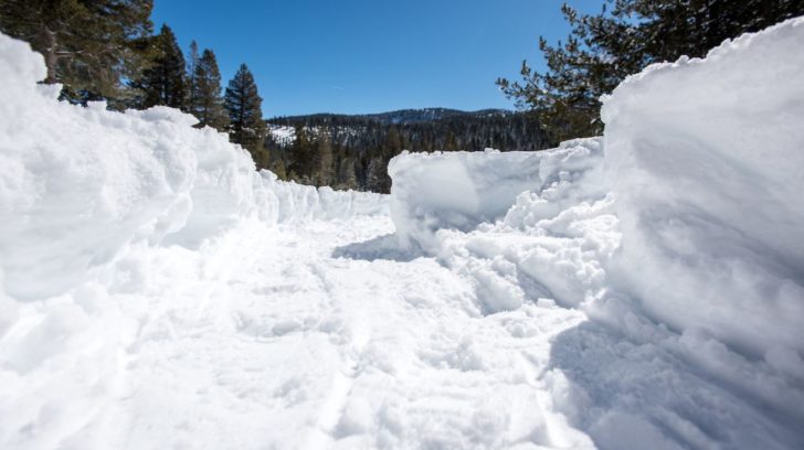
Even with recent major snow in the Sierra Nevada a survey at Phillips Station reveals the current snow pack is well below average. The survey conducted at the Phillips snow course measures the depth of the snow but also calculates the Snow Water Equivalent or SWE.
 SWE is the depth of water that theoretically would result if the entire snowpack melted instantaneously. That measurement is more important than depth in evaluating the status of the snowpack. The snowpack – often called California’s “frozen reservoir “– normally provides about a third of the water for California’s farms and communities as it melts in the spring and summer and fills reservoirs and rivers.
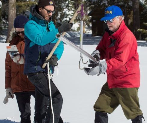
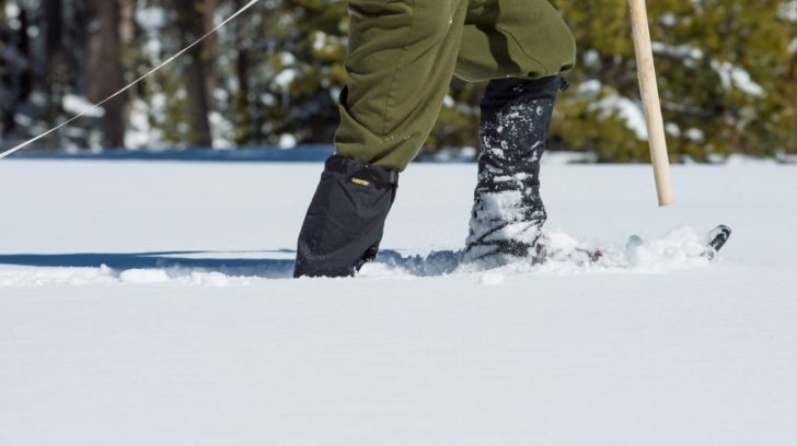 The Phillips snow course, near the intersection of Highway 50 and Sierra-at-Tahoe Road, is one of 260 that are surveyed manually throughout the winter. Manual measurements augment the electronic readings from the snow pillows in the Sierra Nevada that provide a current snapshot of the water content in the snow pack.
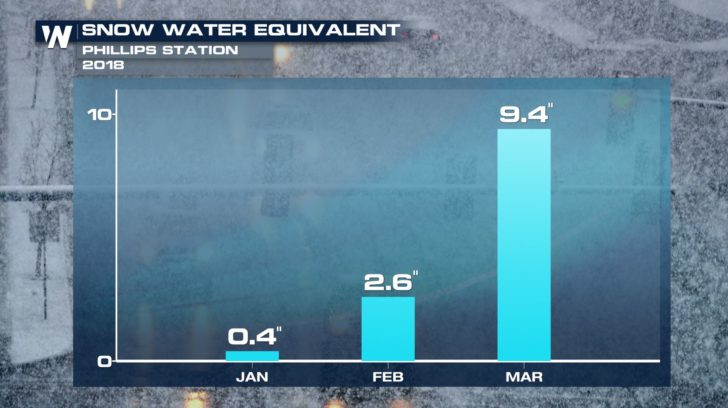
 The snow survey conducted March 5, 2018, was the second measurement at Phillips Station for this snow survey period. On February 28, a snow survey found a SWE of 1.7 inches, or just 7 percent of average for that time of year as recorded since 1964. The second measurement on March 5, 2018 yielded a 32 percentage-point increase in SWE over the previous week where the snow water equivalent (SWE) was 9.4 inches, which is 39 percent of normal for early March. The March 1 average at Phillips is 24.3 inches SWE.
Results of the readings by DWR at Phillips Station:
The snow survey conducted March 5, 2018, was the second measurement at Phillips Station for this snow survey period. On February 28, a snow survey found a SWE of 1.7 inches, or just 7 percent of average for that time of year as recorded since 1964. The second measurement on March 5, 2018 yielded a 32 percentage-point increase in SWE over the previous week where the snow water equivalent (SWE) was 9.4 inches, which is 39 percent of normal for early March. The March 1 average at Phillips is 24.3 inches SWE.
Results of the readings by DWR at Phillips Station:
 Compared to a survey conducted a year ago on March 1, 2017
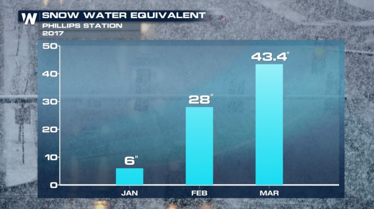
March 1, 2017 manual snow survey by the Department of Water Resources (DWR) at Phillips Station in the Sierra Nevada found a snow water equivalent (SWE) of 43.4 inches.
Compared to a survey conducted a year ago on March 1, 2017
March 1, 2017 manual snow survey by the Department of Water Resources (DWR) at Phillips Station in the Sierra Nevada found a snow water equivalent (SWE) of 43.4 inches.
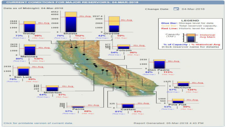
 One good thing to consider is that California’s exceptionally high precipitation last winter and spring has resulted in above-average storage in 154 reservoirs tracked by the Department. DWR estimates total storage in those reservoirs at the end of February 2018 was 24.6 million acre feet (MAF), or about 100 percent of the 24.7 MAF average for the end of February.
http://cdec.water.ca.gov/resapp/RescondMain
One good thing to consider is that California’s exceptionally high precipitation last winter and spring has resulted in above-average storage in 154 reservoirs tracked by the Department. DWR estimates total storage in those reservoirs at the end of February 2018 was 24.6 million acre feet (MAF), or about 100 percent of the 24.7 MAF average for the end of February.
http://cdec.water.ca.gov/resapp/RescondMain
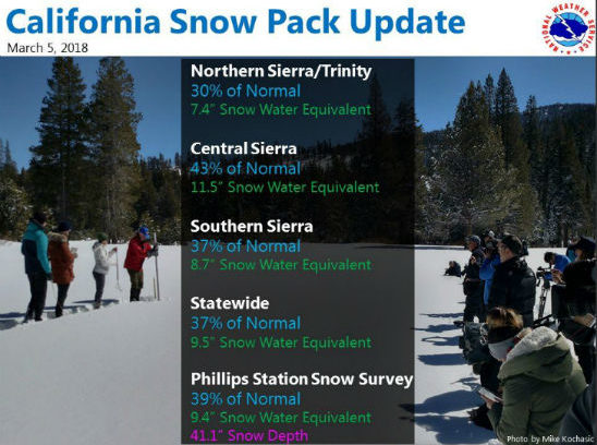
 In addition to the manual surveys conducted at Phillips, DWR also logs electronic readings from 103 stations scattered throughout the Sierra. Electronic measurements indicate the SWE of the northern Sierra snow pack is 7.4 inches, 30 percent of the multi-decade average for March 5th. The central and southern Sierra readings are 11.5 inches (43 percent of average) and 8.7 inches (37 percent of average) respectively. Statewide, the snow pack SWE is 9.5 inches, or 37 percent of the March 5 average. Electronic snow pack readings are available at: http://bit.ly/2rVa84a
California’s climate is the most variable of any state. Historically, it swings from drought to flood and back to drought. To help prepare for these ever-wider extremes, Californians can learn ways to save water every day by visiting SaveOurWater.com.
Credit: California Department of Water Resources
Meteorologist Mike Morrison
In addition to the manual surveys conducted at Phillips, DWR also logs electronic readings from 103 stations scattered throughout the Sierra. Electronic measurements indicate the SWE of the northern Sierra snow pack is 7.4 inches, 30 percent of the multi-decade average for March 5th. The central and southern Sierra readings are 11.5 inches (43 percent of average) and 8.7 inches (37 percent of average) respectively. Statewide, the snow pack SWE is 9.5 inches, or 37 percent of the March 5 average. Electronic snow pack readings are available at: http://bit.ly/2rVa84a
California’s climate is the most variable of any state. Historically, it swings from drought to flood and back to drought. To help prepare for these ever-wider extremes, Californians can learn ways to save water every day by visiting SaveOurWater.com.
Credit: California Department of Water Resources
Meteorologist Mike Morrison
SWE is the depth of water that theoretically would result if the entire snowpack melted instantaneously. That measurement is more important than depth in evaluating the status of the snowpack. The snowpack – often called California’s “frozen reservoir “– normally provides about a third of the water for California’s farms and communities as it melts in the spring and summer and fills reservoirs and rivers.
The Phillips snow course, near the intersection of Highway 50 and Sierra-at-Tahoe Road, is one of 260 that are surveyed manually throughout the winter. Manual measurements augment the electronic readings from the snow pillows in the Sierra Nevada that provide a current snapshot of the water content in the snow pack.
The snow survey conducted March 5, 2018, was the second measurement at Phillips Station for this snow survey period. On February 28, a snow survey found a SWE of 1.7 inches, or just 7 percent of average for that time of year as recorded since 1964. The second measurement on March 5, 2018 yielded a 32 percentage-point increase in SWE over the previous week where the snow water equivalent (SWE) was 9.4 inches, which is 39 percent of normal for early March. The March 1 average at Phillips is 24.3 inches SWE.
Results of the readings by DWR at Phillips Station:
Compared to a survey conducted a year ago on March 1, 2017
March 1, 2017 manual snow survey by the Department of Water Resources (DWR) at Phillips Station in the Sierra Nevada found a snow water equivalent (SWE) of 43.4 inches.
One good thing to consider is that California’s exceptionally high precipitation last winter and spring has resulted in above-average storage in 154 reservoirs tracked by the Department. DWR estimates total storage in those reservoirs at the end of February 2018 was 24.6 million acre feet (MAF), or about 100 percent of the 24.7 MAF average for the end of February.
http://cdec.water.ca.gov/resapp/RescondMain
In addition to the manual surveys conducted at Phillips, DWR also logs electronic readings from 103 stations scattered throughout the Sierra. Electronic measurements indicate the SWE of the northern Sierra snow pack is 7.4 inches, 30 percent of the multi-decade average for March 5th. The central and southern Sierra readings are 11.5 inches (43 percent of average) and 8.7 inches (37 percent of average) respectively. Statewide, the snow pack SWE is 9.5 inches, or 37 percent of the March 5 average. Electronic snow pack readings are available at: http://bit.ly/2rVa84a
California’s climate is the most variable of any state. Historically, it swings from drought to flood and back to drought. To help prepare for these ever-wider extremes, Californians can learn ways to save water every day by visiting SaveOurWater.com.
Credit: California Department of Water Resources
Meteorologist Mike MorrisonAll Weather News
More
More Storms for the East Through Monday
A low-pressure system that moved through the
2 Aug 2026 10:40 PM

Wildfire Outbreak in the Pacific Northwest
SPOKANE, WA - On Saturday, August 1st, the Ol
2 Aug 2026 10:35 PM


After Reaching Category 5, Genevieve Weakens in the Pacific
PacificGenevieve formed on last Friday south
2 Aug 2026 6:25 PM

Flooding, Severe Storms Target the Midwest Again
After an active week of storms across the nor
1 Aug 2026 1:40 AM

Flooding Risk Increases as Heavy Rain Targets the Tri-State Area
Tuesday, heavy rainfall moved across the Nort
30 Jul 2026 12:25 AM

Severe Weather: Energy From the Midwest Now in the Southeast
UPPER MIDWEST - Through Monday, dangerous tor
29 Jul 2026 10:30 PM