Sierra Snowpack Doubles in February
Special Stories
1 Mar 2019 4:39 PM
https://www.youtube.com/watch?v=1ktZG58LsHQ&feature=youtu.be
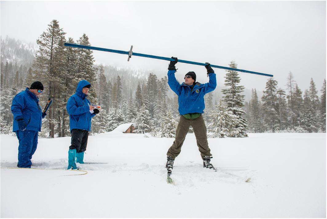
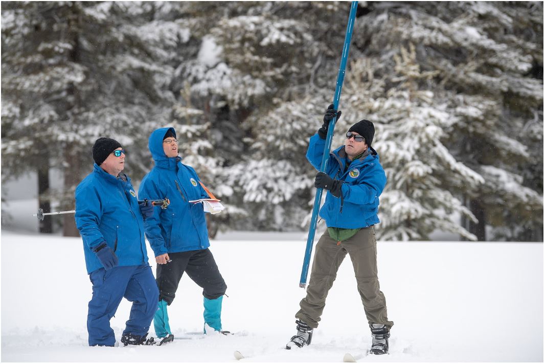
As heavy snow fell on Febuary 28, the Department of Water Resources (DWR) conducted its third Phillips Station snow survey of 2019. The survey measures the current snowpack in one location to get a better picture of the Sierra Nevada's water content as a whole. For the final recording of February, Phillips Station hit 113 inches of snow depth and a snow water equivalent (SWE) of 43.5 inches. This is more than double what was recorded last month at this location! Compared to last year, when in the snow depth was only 13.5 inches and the SWE was just 1.5 inches. Multiple atmospheric river enhanced storms helped boost numbers in a big way. As of March 1, the statewide Sierra snowpack sits at 153% of normal.
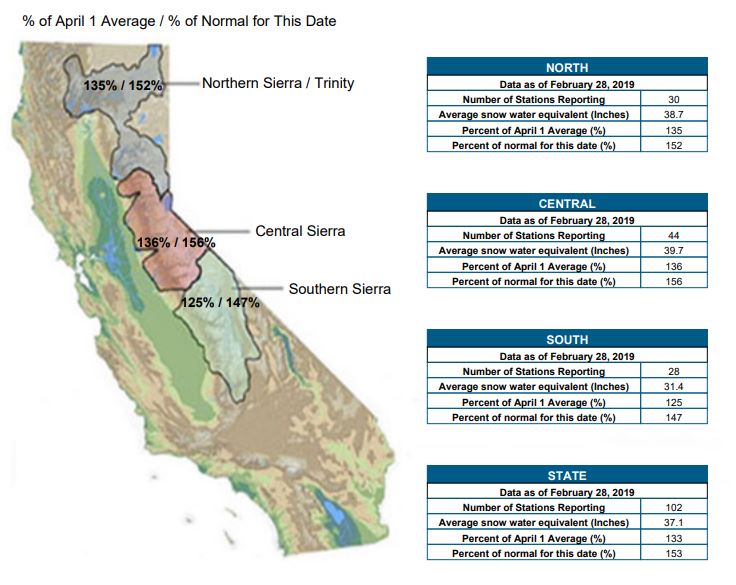 Current Regional Snowpack from Automated Snow Sensors Source: CA DWR
SWE is extremely important for drinking water and drought considerations. It is defined as the "depth of water that theoretically would result if the entire snowpack melted instantaneously."
“This winter’s snowpack gets better each month and it looks like California storms aren’t done giving yet,” said DWR Director Karla Nemeth. “This is shaping up to be an excellent water year.”
Current Regional Snowpack from Automated Snow Sensors Source: CA DWR
SWE is extremely important for drinking water and drought considerations. It is defined as the "depth of water that theoretically would result if the entire snowpack melted instantaneously."
“This winter’s snowpack gets better each month and it looks like California storms aren’t done giving yet,” said DWR Director Karla Nemeth. “This is shaping up to be an excellent water year.”
 As of Valentine's Day, El Nino conditions were confirmed by NOAA and the NWS in the Northern Hemisphere. Climatologically, this usually means higher than average precipitation for March and April in California.
“Along with the water supply benefits of the heavy rain and snow, there is also increased flood risk,” said John Paasch, DWR Chief of Flood Operations. “We’ve activated the Flood Operations Center, a joint effort between DWR and the National Weather Service, to closely monitor weather, reservoir, river, and flood conditions. Our goal is to share timely and accurate information about changing conditions to help people and communities respond to flood events and stay safe.”
According to the California Department of Water Resources, the state’s six largest reservoirs currently hold between 84 percent (Oroville) and 137 percent (Melones) of their historical averages for this date. Lake Shasta, California’s largest surface reservoir, is 112 percent of its historical average.
For WeatherNation, I'm Meteorologist Karissa Klos.
Source: CA DWR
As of Valentine's Day, El Nino conditions were confirmed by NOAA and the NWS in the Northern Hemisphere. Climatologically, this usually means higher than average precipitation for March and April in California.
“Along with the water supply benefits of the heavy rain and snow, there is also increased flood risk,” said John Paasch, DWR Chief of Flood Operations. “We’ve activated the Flood Operations Center, a joint effort between DWR and the National Weather Service, to closely monitor weather, reservoir, river, and flood conditions. Our goal is to share timely and accurate information about changing conditions to help people and communities respond to flood events and stay safe.”
According to the California Department of Water Resources, the state’s six largest reservoirs currently hold between 84 percent (Oroville) and 137 percent (Melones) of their historical averages for this date. Lake Shasta, California’s largest surface reservoir, is 112 percent of its historical average.
For WeatherNation, I'm Meteorologist Karissa Klos.
Source: CA DWR
Current Regional Snowpack from Automated Snow Sensors Source: CA DWR
SWE is extremely important for drinking water and drought considerations. It is defined as the "depth of water that theoretically would result if the entire snowpack melted instantaneously."
“This winter’s snowpack gets better each month and it looks like California storms aren’t done giving yet,” said DWR Director Karla Nemeth. “This is shaping up to be an excellent water year.”
As of Valentine's Day, El Nino conditions were confirmed by NOAA and the NWS in the Northern Hemisphere. Climatologically, this usually means higher than average precipitation for March and April in California.
“Along with the water supply benefits of the heavy rain and snow, there is also increased flood risk,” said John Paasch, DWR Chief of Flood Operations. “We’ve activated the Flood Operations Center, a joint effort between DWR and the National Weather Service, to closely monitor weather, reservoir, river, and flood conditions. Our goal is to share timely and accurate information about changing conditions to help people and communities respond to flood events and stay safe.”
According to the California Department of Water Resources, the state’s six largest reservoirs currently hold between 84 percent (Oroville) and 137 percent (Melones) of their historical averages for this date. Lake Shasta, California’s largest surface reservoir, is 112 percent of its historical average.
For WeatherNation, I'm Meteorologist Karissa Klos.
Source: CA DWRAll Weather News
More

Flooding, Severe Storms Target the Midwest Again
After an active week of storms across the nor
1 Aug 2026 1:40 AM


After Reaching Category 5, Genevieve Weakens in the Pacific
PacificFausto is now a post-tropical cyclone.
31 Jul 2026 1:30 AM

Flooding Risk Increases as Heavy Rain Targets the Tri-State Area
Tuesday, heavy rainfall moved across the Nort
30 Jul 2026 12:25 AM

Severe Weather: Energy From the Midwest Now in the Southeast
UPPER MIDWEST - Through Monday, dangerous tor
29 Jul 2026 10:30 PM