Significant System Forecast For The West
Top Stories
5 Jan 2018 6:27 PM
Multiple storm systems will impact the West through the early part of this upcoming week, but the biggest will arrive on Monday.
https://twitter.com/NWSReno/status/949037675008483328
The West will already be getting its first in a series of storm systems on Saturday morning with a rain/snow mix for several states. This will be a light to moderate event with some sleet and freezing rain mixing in at times. Snow levels across the West Saturday will be quite high, roughly around 7,000-8,000 feet meaning it will stay all snow above that level, more of a mix or all rain below.
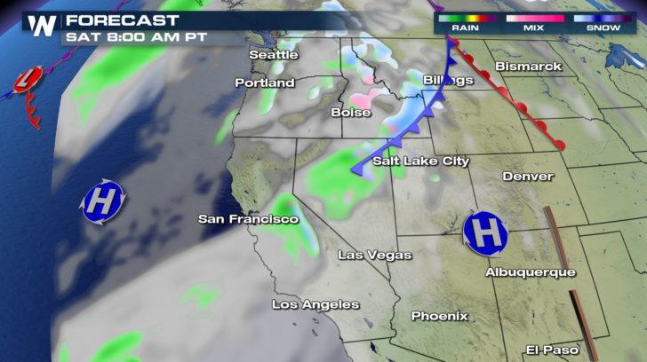 The forecast surface map on Saturday morning, January 6. Green shows projected rain, pink shows freezing rain or sleet, and blue shows snow.
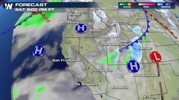 The forecast surface map on Saturday evening, January 6. Green shows projected rain, pink shows freezing rain or sleet, and blue shows snow.
There are winter weather alerts in effect for Saturday and Saturday night's snow and mixed precipitation.
The forecast surface map on Saturday evening, January 6. Green shows projected rain, pink shows freezing rain or sleet, and blue shows snow.
There are winter weather alerts in effect for Saturday and Saturday night's snow and mixed precipitation.
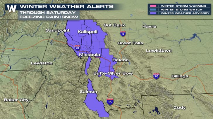 A winter weather advisory is in effect for parts of Montana and Idaho through midday Saturday, January 6.
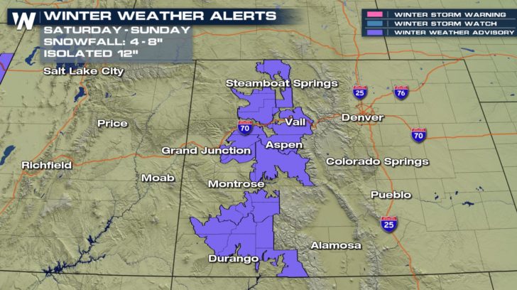 A winter weather advisory is in effect beginning Saturday afternoon and lasting through Sunday morning for parts of Colorado.
With the first batch of moisture Saturday and Sunday you can expect to get 0.25-0.75" of precipitation, rainfall at the lower elevations and about 4-8" of snow for the higher elevations. Snowfall may peak at 12-14" at some of the highest summits and locations that sit at just the right spot.
A winter weather advisory is in effect beginning Saturday afternoon and lasting through Sunday morning for parts of Colorado.
With the first batch of moisture Saturday and Sunday you can expect to get 0.25-0.75" of precipitation, rainfall at the lower elevations and about 4-8" of snow for the higher elevations. Snowfall may peak at 12-14" at some of the highest summits and locations that sit at just the right spot.
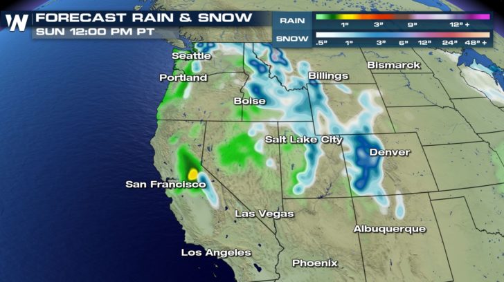 Forecast precipitation accumulation through Sunday.
Then the next, and much stronger, weather disturbance will arrive on Monday and last through the middle of the upcoming week!
Forecast precipitation accumulation through Sunday.
Then the next, and much stronger, weather disturbance will arrive on Monday and last through the middle of the upcoming week!
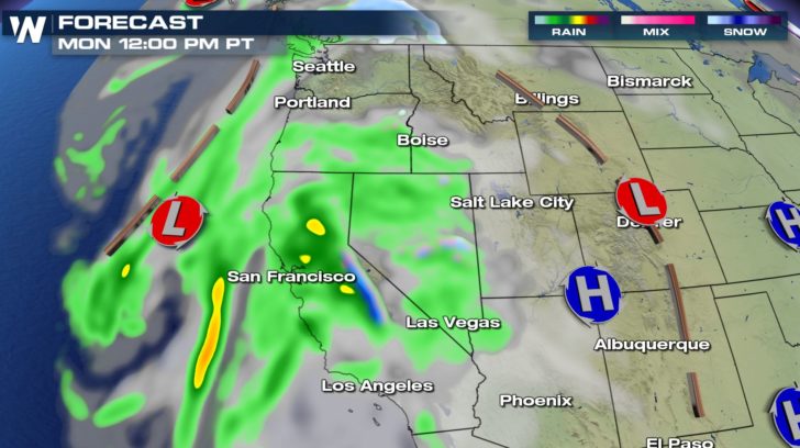 The forecast surface map on Monday, January 8. Green shows projected rain, pink shows freezing rain or sleet, and blue shows snow.
This will be the strongest weather system this area has seen in several weeks. Winds at the lower elevation may gust up to 30 mph, however may gust up to 60-70 mph at the mountain passes. Plus there will be much more moisture associated with this system. That means heavier rain and snow on the way!
The forecast surface map on Monday, January 8. Green shows projected rain, pink shows freezing rain or sleet, and blue shows snow.
This will be the strongest weather system this area has seen in several weeks. Winds at the lower elevation may gust up to 30 mph, however may gust up to 60-70 mph at the mountain passes. Plus there will be much more moisture associated with this system. That means heavier rain and snow on the way!
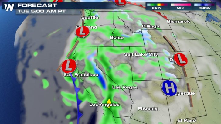 The forecast surface map on Tuesday, January 9. Green shows projected rain, pink shows freezing rain or sleet, and blue shows snow.
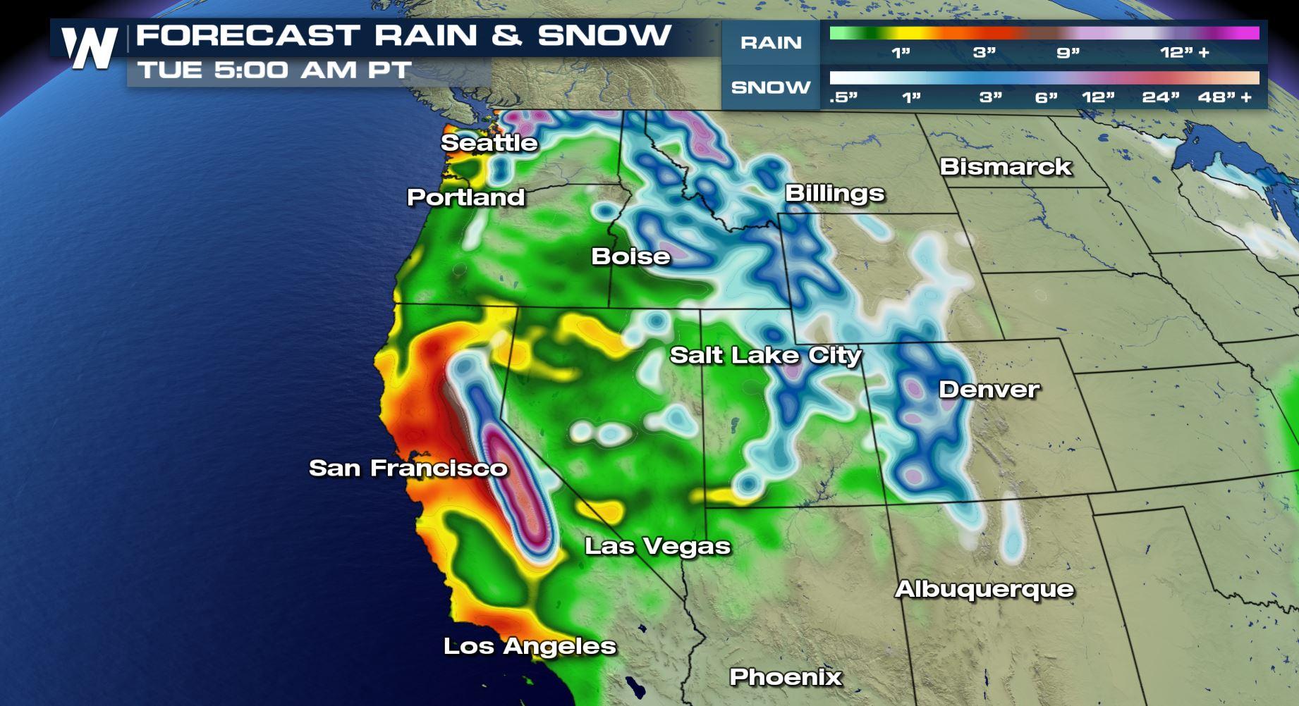
When you put the multiple storms together, several inches of liquid precipitation is in the forecast for the West. That will even translate to potentially multiple feet of snow for the highest elevations. With the next system coming in Monday and Tuesday, snow levels will be around 7,000 feet with highest snow potential above that elevation. All in all, here's what the precipitation forecast looks like into early Tuesday.
The forecast surface map on Tuesday, January 9. Green shows projected rain, pink shows freezing rain or sleet, and blue shows snow.
When you put the multiple storms together, several inches of liquid precipitation is in the forecast for the West. That will even translate to potentially multiple feet of snow for the highest elevations. With the next system coming in Monday and Tuesday, snow levels will be around 7,000 feet with highest snow potential above that elevation. All in all, here's what the precipitation forecast looks like into early Tuesday.
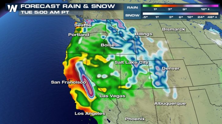 Forecast rain and snow between Friday night (5th) to Tuesday morning (9th).
Our WeatherNation team will update you on additional alerts and forecast numbers as this story unfolds.
For WeatherNation, Meteorologist Steve Glazier
Forecast rain and snow between Friday night (5th) to Tuesday morning (9th).
Our WeatherNation team will update you on additional alerts and forecast numbers as this story unfolds.
For WeatherNation, Meteorologist Steve Glazier
The forecast surface map on Saturday morning, January 6. Green shows projected rain, pink shows freezing rain or sleet, and blue shows snow.
The forecast surface map on Saturday evening, January 6. Green shows projected rain, pink shows freezing rain or sleet, and blue shows snow.
There are winter weather alerts in effect for Saturday and Saturday night's snow and mixed precipitation.
A winter weather advisory is in effect for parts of Montana and Idaho through midday Saturday, January 6.
A winter weather advisory is in effect beginning Saturday afternoon and lasting through Sunday morning for parts of Colorado.
With the first batch of moisture Saturday and Sunday you can expect to get 0.25-0.75" of precipitation, rainfall at the lower elevations and about 4-8" of snow for the higher elevations. Snowfall may peak at 12-14" at some of the highest summits and locations that sit at just the right spot.
Forecast precipitation accumulation through Sunday.
Then the next, and much stronger, weather disturbance will arrive on Monday and last through the middle of the upcoming week!
The forecast surface map on Monday, January 8. Green shows projected rain, pink shows freezing rain or sleet, and blue shows snow.
This will be the strongest weather system this area has seen in several weeks. Winds at the lower elevation may gust up to 30 mph, however may gust up to 60-70 mph at the mountain passes. Plus there will be much more moisture associated with this system. That means heavier rain and snow on the way!
The forecast surface map on Tuesday, January 9. Green shows projected rain, pink shows freezing rain or sleet, and blue shows snow.
When you put the multiple storms together, several inches of liquid precipitation is in the forecast for the West. That will even translate to potentially multiple feet of snow for the highest elevations. With the next system coming in Monday and Tuesday, snow levels will be around 7,000 feet with highest snow potential above that elevation. All in all, here's what the precipitation forecast looks like into early Tuesday.
Forecast rain and snow between Friday night (5th) to Tuesday morning (9th).
Our WeatherNation team will update you on additional alerts and forecast numbers as this story unfolds.
For WeatherNation, Meteorologist Steve GlazierAll Weather News
More
Fronts Continue To Spark Severe Weather Across the Plains
A cold front that brought record lows to the
18 Jul 2025 10:40 PM

Extreme Heat Impacts for the East Coast & South
Extreme heat continues to impact several area
18 Jul 2025 10:05 PM

Flooding Threat Remains Elevated in the East
A cold front pushing through the Eastern Seab
18 Jul 2025 9:10 PM

EF-2 Firenado from the Deer Creek Fire in Utah
A fire tornado was spotted near La Sal, Utah
18 Jul 2025 7:30 AM

Tropical System Brings Flood Risk to the Central Gulf
Time has run out for notable tropical develop
18 Jul 2025 3:05 AM

Heavy Rain, Flooding Threat Returns to Florida
Keep the rain boots handy in Florida - heavy
13 Jul 2025 12:50 PM

Severe Storm Risk Pushes into the Great Lakes, Ohio Valley
Friday was another busy day with severe weath
12 Jul 2025 8:00 PM