Small Unmanned Aircraft Flies Into Rapidly Intensifying Hurricane Michael
Special Stories
17 Oct 2018 8:34 AM
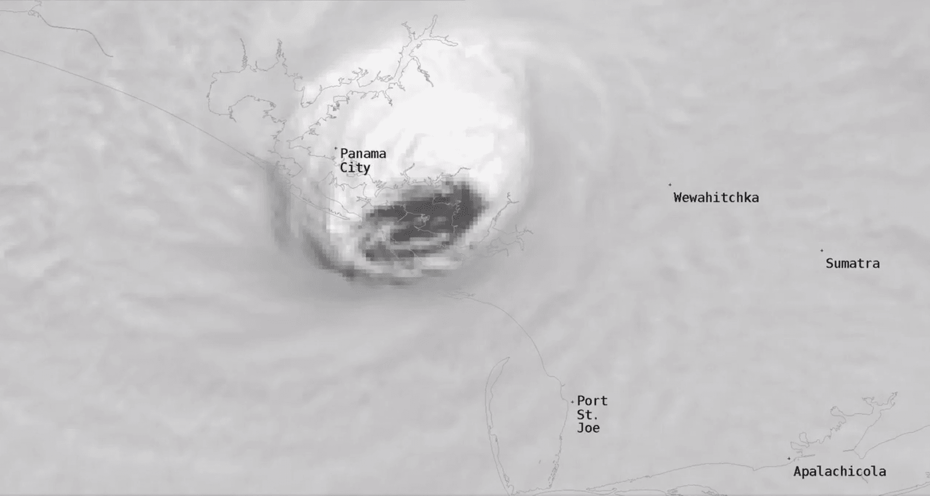
[Close-up satellite image of the eye of Hurricane Michael as it made landfall at Mexico Beach, Florida last Wednesday afternoon, October 10th.]
[NOAA] NOAA scientists flew multiple missions into Hurricane Michael in the days before landfall, closely observing the rapid intensification of the storm. Their tools included a small unmanned aircraft, called the Coyote, which flew into the strongest winds of the eyewall as the storm intensified to a category 4 on the Saffir-Simpson scale.
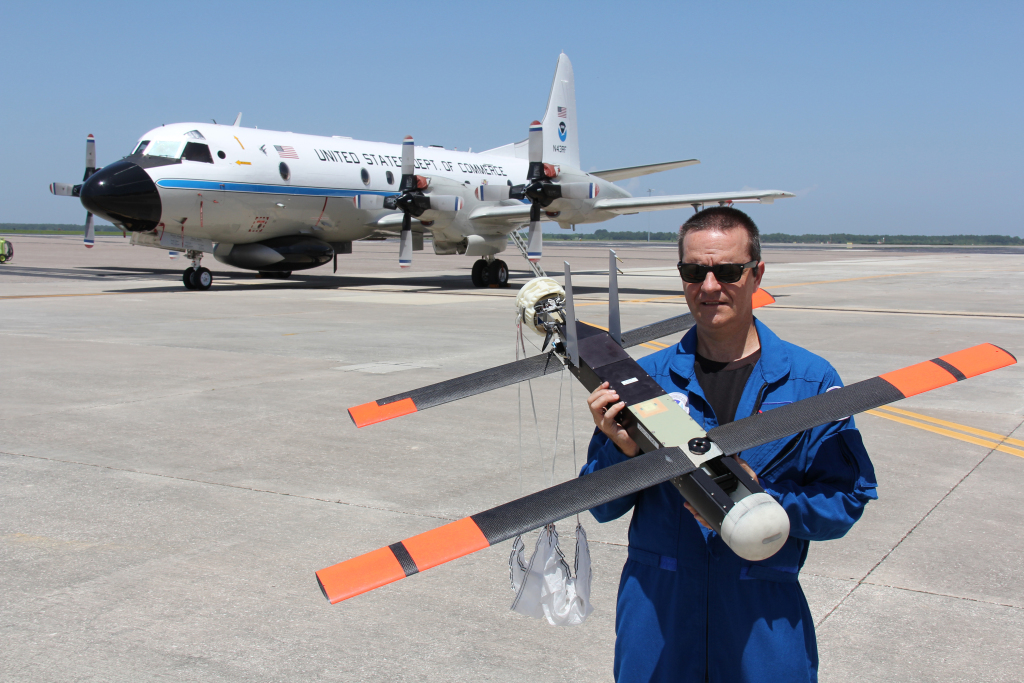 [Joe Cione of NOAA's Atlantic Oceanographic and Meteorological Lab Hurricane Research Division helped fly this Coyote unmanned aircraft into Hurricane Michael. Credit: NOAA]
NOAA has flown small unmanned aircraft in several hurricanes, including Hurricane Maria in 2017, each time further pushing the limits of how much turbulence and wind it can handle as it sends measurements of wind speed and direction, temperature, air pressure, and moisture that scientists need to better understand, model, and forecast rapidly intensifying storms. In Michael, hurricane researchers with NOAA’s Atlantic Oceanographic and Meteorological Laboratory were able to successfully fly the Coyote in the extremely strong winds of the eyewall, measuring winds up to 183 mph at 2085 feet of altitude.
Hurricanes like Michael are exactly why NOAA is using such new approaches to observe storms, to help advance hurricane models so that forecasters can provide as much advance warning as possible of the expected storm intensity and conditions. Observing the hurricane boundary layer, the lowest thousand feet or so of hurricanes, will help us improve rapid-intensity forecasts.
[Joe Cione of NOAA's Atlantic Oceanographic and Meteorological Lab Hurricane Research Division helped fly this Coyote unmanned aircraft into Hurricane Michael. Credit: NOAA]
NOAA has flown small unmanned aircraft in several hurricanes, including Hurricane Maria in 2017, each time further pushing the limits of how much turbulence and wind it can handle as it sends measurements of wind speed and direction, temperature, air pressure, and moisture that scientists need to better understand, model, and forecast rapidly intensifying storms. In Michael, hurricane researchers with NOAA’s Atlantic Oceanographic and Meteorological Laboratory were able to successfully fly the Coyote in the extremely strong winds of the eyewall, measuring winds up to 183 mph at 2085 feet of altitude.
Hurricanes like Michael are exactly why NOAA is using such new approaches to observe storms, to help advance hurricane models so that forecasters can provide as much advance warning as possible of the expected storm intensity and conditions. Observing the hurricane boundary layer, the lowest thousand feet or so of hurricanes, will help us improve rapid-intensity forecasts.
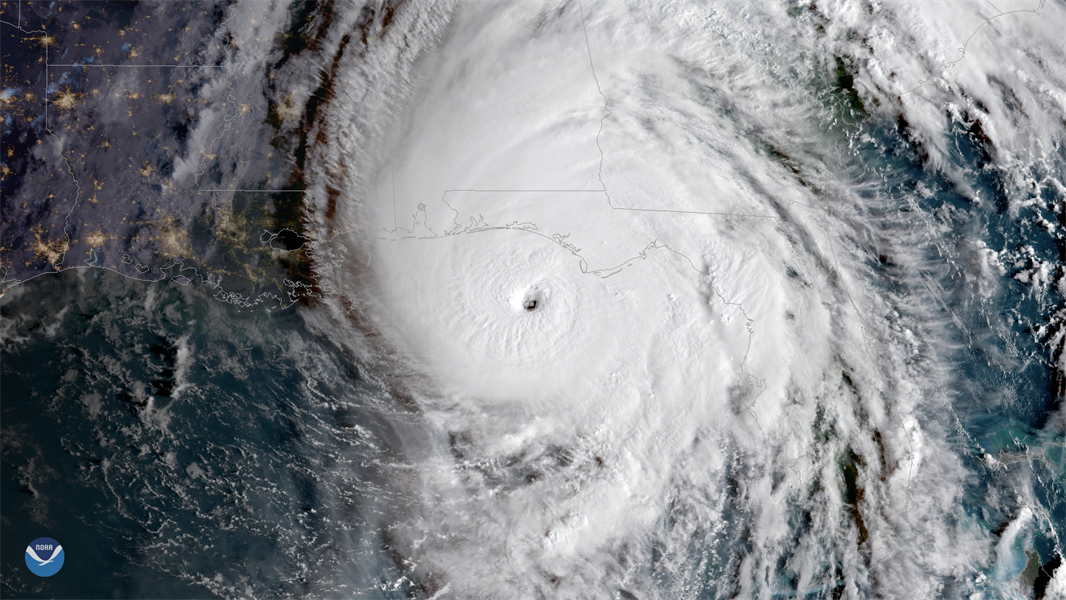 [Hurricane Michael before landfall. From NOAA]
“Knowing this unmanned platform is capable of withstanding such turbulence and wind speeds gives up hope that we can rely on this approach to collect observations in rapidly intensifying storms,” said Joe Cione, NOAA scientist. “These observations can help us improve models that inform forecasts that evacuation decisions are based on."
Edited for WeatherNation by Meteorologist Mace Michaels
[Hurricane Michael before landfall. From NOAA]
“Knowing this unmanned platform is capable of withstanding such turbulence and wind speeds gives up hope that we can rely on this approach to collect observations in rapidly intensifying storms,” said Joe Cione, NOAA scientist. “These observations can help us improve models that inform forecasts that evacuation decisions are based on."
Edited for WeatherNation by Meteorologist Mace Michaels
[Joe Cione of NOAA's Atlantic Oceanographic and Meteorological Lab Hurricane Research Division helped fly this Coyote unmanned aircraft into Hurricane Michael. Credit: NOAA]
NOAA has flown small unmanned aircraft in several hurricanes, including Hurricane Maria in 2017, each time further pushing the limits of how much turbulence and wind it can handle as it sends measurements of wind speed and direction, temperature, air pressure, and moisture that scientists need to better understand, model, and forecast rapidly intensifying storms. In Michael, hurricane researchers with NOAA’s Atlantic Oceanographic and Meteorological Laboratory were able to successfully fly the Coyote in the extremely strong winds of the eyewall, measuring winds up to 183 mph at 2085 feet of altitude.
Hurricanes like Michael are exactly why NOAA is using such new approaches to observe storms, to help advance hurricane models so that forecasters can provide as much advance warning as possible of the expected storm intensity and conditions. Observing the hurricane boundary layer, the lowest thousand feet or so of hurricanes, will help us improve rapid-intensity forecasts.
[Hurricane Michael before landfall. From NOAA]
“Knowing this unmanned platform is capable of withstanding such turbulence and wind speeds gives up hope that we can rely on this approach to collect observations in rapidly intensifying storms,” said Joe Cione, NOAA scientist. “These observations can help us improve models that inform forecasts that evacuation decisions are based on."
Edited for WeatherNation by Meteorologist Mace MichaelsAll Weather News
More
Fronts Continue To Spark Severe Weather Across the Plains
A cold front that brought record lows to the
18 Jul 2025 10:40 PM

Extreme Heat Impacts for the East Coast & South
Extreme heat continues to impact several area
18 Jul 2025 10:05 PM

Flooding Threat Remains Elevated in the East
A cold front pushing through the Eastern Seab
18 Jul 2025 9:10 PM

EF-2 Firenado from the Deer Creek Fire in Utah
A fire tornado was spotted near La Sal, Utah
18 Jul 2025 7:30 AM

Tropical System Brings Flood Risk to the Central Gulf
Time has run out for notable tropical develop
18 Jul 2025 3:05 AM

Heavy Rain, Flooding Threat Returns to Florida
Keep the rain boots handy in Florida - heavy
13 Jul 2025 12:50 PM

Severe Storm Risk Pushes into the Great Lakes, Ohio Valley
Friday was another busy day with severe weath
12 Jul 2025 8:00 PM