Snow and Cold Continue to Grip the Northwest
Special Stories
29 Sep 2019 4:35 PM
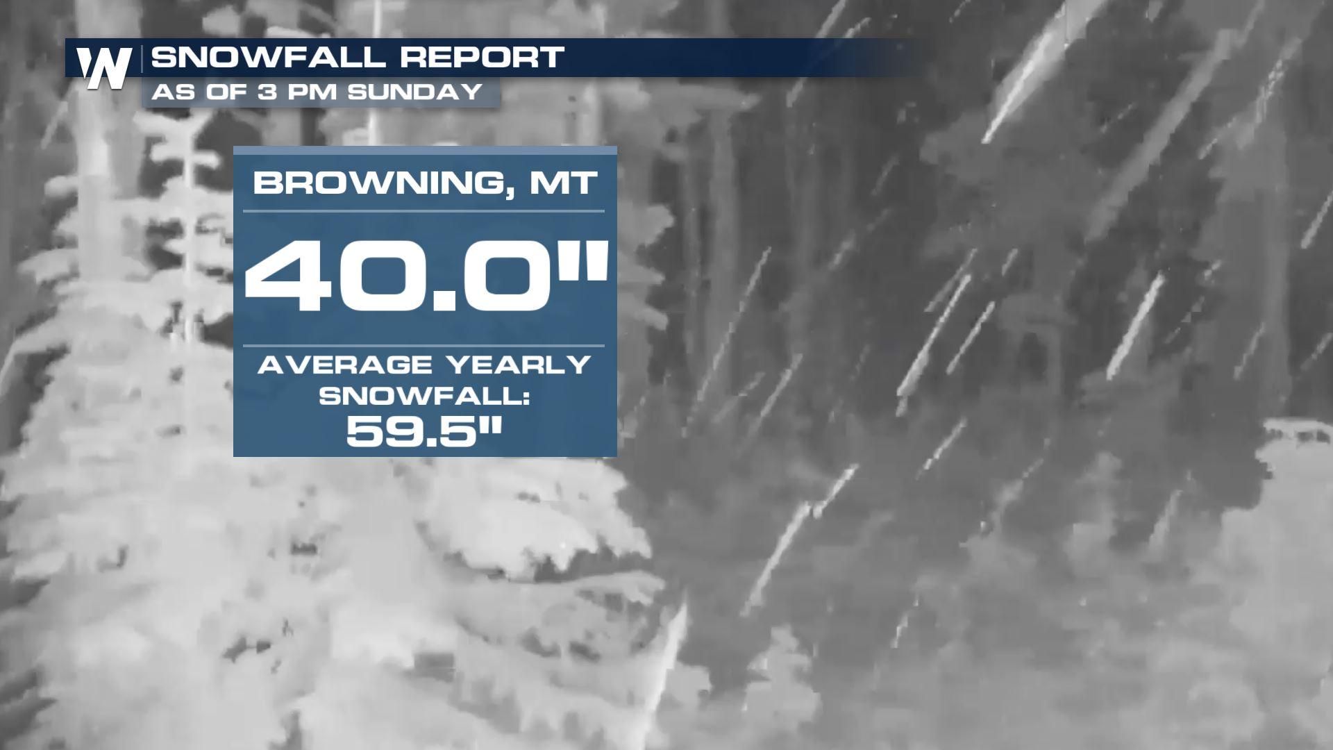
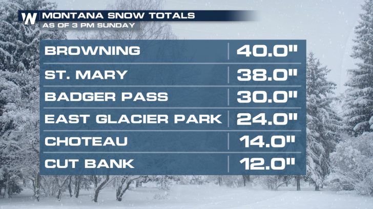
A powerful early season winter storm continues to impact the Northern Rockies. Several locations have already picked up over a foot of snow! Browning, MT has been buried under almost three and a half feet of snow since Friday. That's over two-thirds of their average annual snowfall....and it's still snowing.
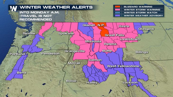
 Snow will continue into Monday morning. This snow is wet which means it is also heavy. This puts a strain on trees and power lines. Tree damage and power outages are still likely this evening. Travel will remain hazardous through the night and early Monday. If possible, stay home until the storm settles late-morning Monday.
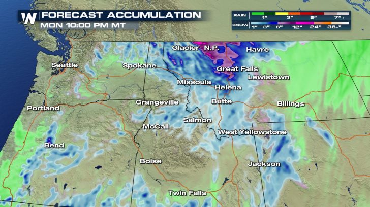
 Several inches of additional snowfall is possible. This is the estimated accumulation for just Sunday evening through Monday.
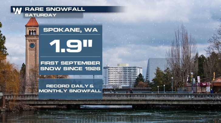
 While feet of snow pile up in the mountains, some of the lower elevations have seen their first measurable September snow in almost a century.
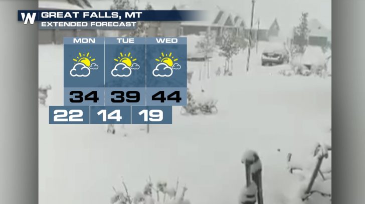
 All of this snow comes along with bitterly cold conditions. Even though the snow will start to slow down on Monday in places like Great Falls, it's going to remain extremely cold. Overnight temperatures will drop into the teens Tuesday and Wednesday. Throw a little wind into the mix and wind chills will be in the single digits for parts of Montana.
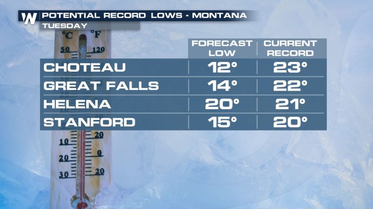
 Several records are in jeopardy this week. Choteau looks to kick off the month of October with a morning low of 12 degrees. That would shatter the previous record by over 10 degrees!
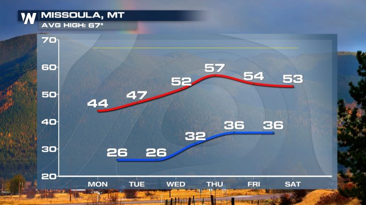
 Temperatures will gradually warm up across the region, but not by much. Highs will remain well-below average in Missoula even into next weekend.
 Stay warm and stay safe folks!
Snow will continue into Monday morning. This snow is wet which means it is also heavy. This puts a strain on trees and power lines. Tree damage and power outages are still likely this evening. Travel will remain hazardous through the night and early Monday. If possible, stay home until the storm settles late-morning Monday.
Several inches of additional snowfall is possible. This is the estimated accumulation for just Sunday evening through Monday.
While feet of snow pile up in the mountains, some of the lower elevations have seen their first measurable September snow in almost a century.
All of this snow comes along with bitterly cold conditions. Even though the snow will start to slow down on Monday in places like Great Falls, it's going to remain extremely cold. Overnight temperatures will drop into the teens Tuesday and Wednesday. Throw a little wind into the mix and wind chills will be in the single digits for parts of Montana.
Several records are in jeopardy this week. Choteau looks to kick off the month of October with a morning low of 12 degrees. That would shatter the previous record by over 10 degrees!
Temperatures will gradually warm up across the region, but not by much. Highs will remain well-below average in Missoula even into next weekend.
Stay warm and stay safe folks!All Weather News
More
Wildfire Outbreak in the Pacific Northwest
SPOKANE, WA - On Saturday, August 1st, the Ol
3 Aug 2026 1:55 AM

More Storms for the East Through Monday
A low-pressure system that moved through the
3 Aug 2026 1:50 AM


After Reaching Category 5, Genevieve Weakens in the Pacific
PacificGenevieve formed last Friday south of
3 Aug 2026 12:30 AM

Flooding, Severe Storms Target the Midwest Again
After an active week of storms across the nor
1 Aug 2026 1:40 AM

Flooding Risk Increases as Heavy Rain Targets the Tri-State Area
Tuesday, heavy rainfall moved across the Nort
30 Jul 2026 12:25 AM

Severe Weather: Energy From the Midwest Now in the Southeast
UPPER MIDWEST - Through Monday, dangerous tor
29 Jul 2026 10:30 PM