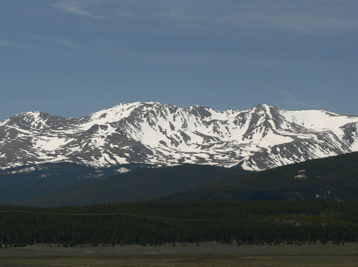
Snowpack in Colorado is Rising, But Still Below Normal.
Special Stories
8 Feb 2018 5:15 PM
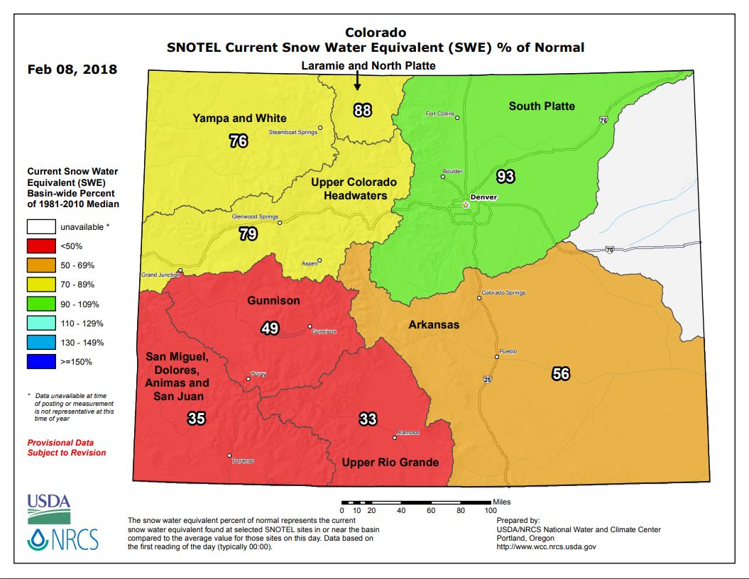
Each year, the snowpack in Colorado is very closely monitored. Ski resorts need it to operate. But the snow is also critical for drinking water, and it lowers the wildfire threat during the dry season. In early January, Colorado's snowpack levels were the worst in thirty years. But several January snow events brought parts of Colorado close to average for this time of the year. The South Platte Basin is now 93% of normal. And the Upper Colorado Headwaters Basin is also doing much better than a month ago at 79% of normal. But the southern portion of the state is still well below average. The Gunnison Basin snowpack is just under half of normal levels, while the Upper Rio Grande snowpack is only a third of normal. March is typically the snowiest month of the year. Hopefully some big snow events will help the Colorado Rockies catch up after a slow start.
 -
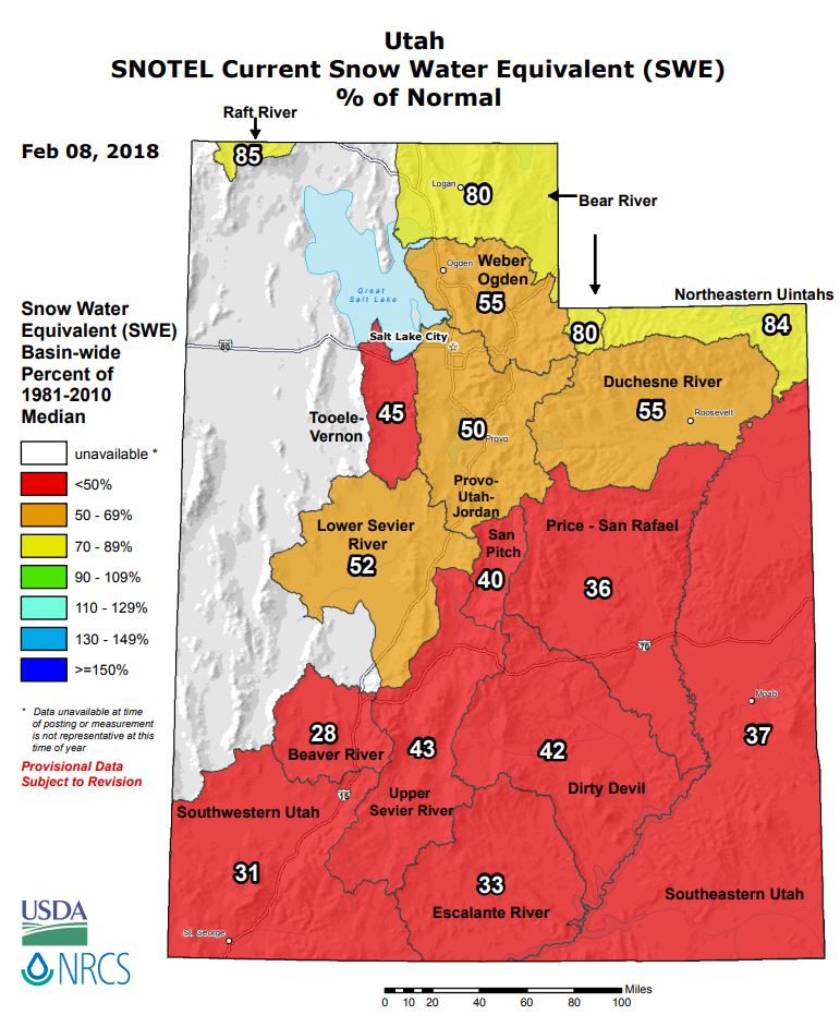
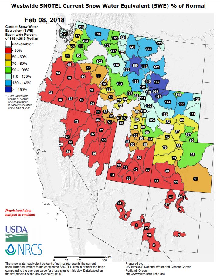
Farther to the west, much of Utah has received less than half of the moisture it usually does at this point in the wet season. Only the northern-most portions of the state are even close to normal levels, at or above 80%.
-
Farther to the west, much of Utah has received less than half of the moisture it usually does at this point in the wet season. Only the northern-most portions of the state are even close to normal levels, at or above 80%.
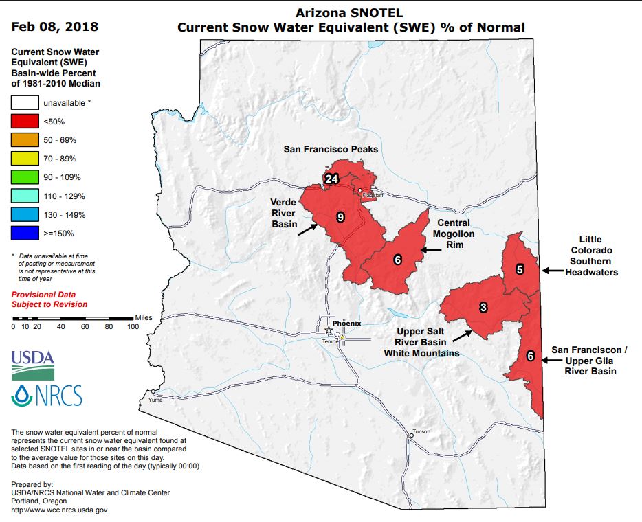
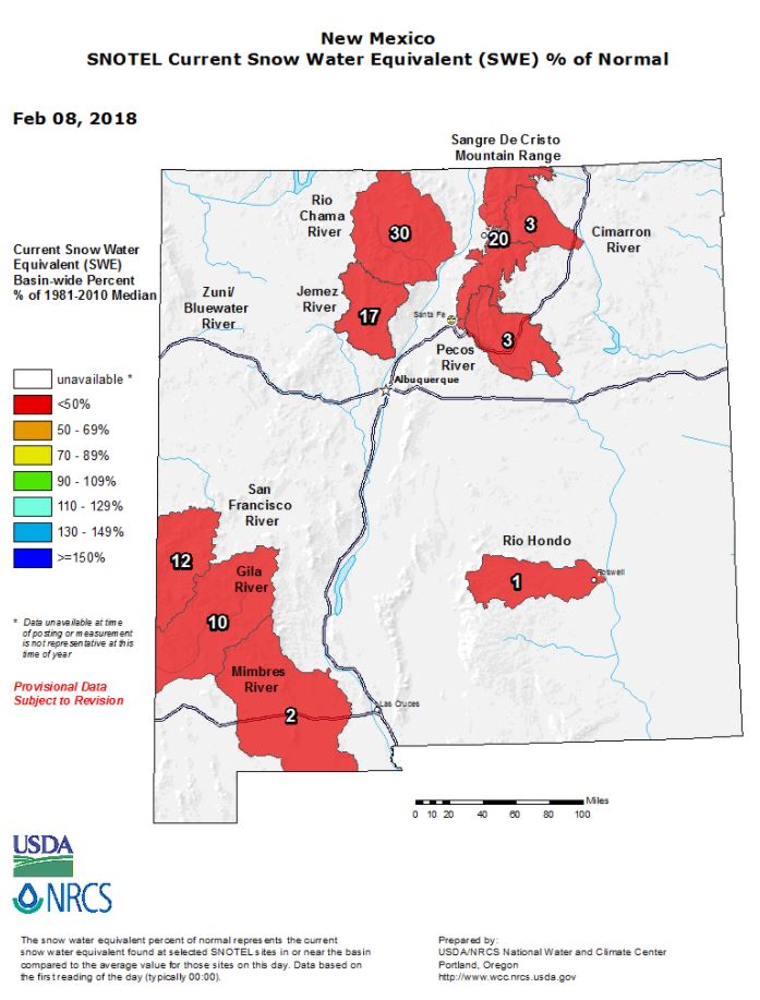
 And moisture has really been lacking in Arizona and New Mexico. Check out the snow water equivalent maps below. Some of the mountainous regions in these states have less than 10% of their normal moisture levels. And all areas are at or below 30% of normal levels.
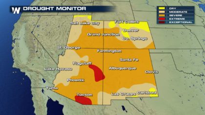
 It should come as no surprise, that the majority of the Four Corners Region is in a Severe Drought. The areas shaded in red in Arizona are in Extreme Drought.
 So where is all of the moisture going this season? Wyoming, Montana, Idaho, and Washington. The snowpack in the northern Rockies is way above average so far this season. The Tetons in Wyoming and the Montana Rockies have snow water equivalent levels between 159% and 167%. And the ski resorts have been loving all the snow. Even northern Washington State has above average moisture levels of 130%. In fact, most of Washington State is doing pretty well in the moisture department. However, Oregon, just to the south, needs some help.
 There have been a number of big winter storms that have come in from the Pacific Ocean. And the tracks of these storms have been very similar. The storms come across Washington State, spreading rain and snow into Idaho, Montana and Wyoming. The storms then move off to the east, and away from the Four Corners states. But will this pattern break down in the latter part of the winter? That's the big question. If so, then the Wasatch and southern Rockies could get more snow. However, if the current pattern holds for the next two months, look for the drought conditions to worsen across the southwest.
For WeatherNation: Meteorologist Matt Monroe
There have been a number of big winter storms that have come in from the Pacific Ocean. And the tracks of these storms have been very similar. The storms come across Washington State, spreading rain and snow into Idaho, Montana and Wyoming. The storms then move off to the east, and away from the Four Corners states. But will this pattern break down in the latter part of the winter? That's the big question. If so, then the Wasatch and southern Rockies could get more snow. However, if the current pattern holds for the next two months, look for the drought conditions to worsen across the southwest.
For WeatherNation: Meteorologist Matt Monroe
-
Farther to the west, much of Utah has received less than half of the moisture it usually does at this point in the wet season. Only the northern-most portions of the state are even close to normal levels, at or above 80%.
And moisture has really been lacking in Arizona and New Mexico. Check out the snow water equivalent maps below. Some of the mountainous regions in these states have less than 10% of their normal moisture levels. And all areas are at or below 30% of normal levels.
It should come as no surprise, that the majority of the Four Corners Region is in a Severe Drought. The areas shaded in red in Arizona are in Extreme Drought.
So where is all of the moisture going this season? Wyoming, Montana, Idaho, and Washington. The snowpack in the northern Rockies is way above average so far this season. The Tetons in Wyoming and the Montana Rockies have snow water equivalent levels between 159% and 167%. And the ski resorts have been loving all the snow. Even northern Washington State has above average moisture levels of 130%. In fact, most of Washington State is doing pretty well in the moisture department. However, Oregon, just to the south, needs some help.
There have been a number of big winter storms that have come in from the Pacific Ocean. And the tracks of these storms have been very similar. The storms come across Washington State, spreading rain and snow into Idaho, Montana and Wyoming. The storms then move off to the east, and away from the Four Corners states. But will this pattern break down in the latter part of the winter? That's the big question. If so, then the Wasatch and southern Rockies could get more snow. However, if the current pattern holds for the next two months, look for the drought conditions to worsen across the southwest.
For WeatherNation: Meteorologist Matt MonroeAll Weather News
More

Tropics: Fausto Heads towards Hawaii; Genevieve Cat 4 Hurricane
PacificTropical Storm Fausto continues to tra
28 Jul 2026 10:30 AM

Severe Storms Target the Midwest to the Northeast
UPPER MIDWEST - Through Monday, dangerous tor
28 Jul 2026 10:25 AM

Southeast Flood Risk Lingers Near Stalled Front
A stalled boundary over the Southeast will ke
25 Jul 2026 10:55 AM

Another Round of Storms Targets the Northeast
Tuesday brought severe weather again across p
23 Jul 2026 1:15 AM

Another Round of Severe Weather for the Upper Midwest and Great Lakes
The upper-level low train continues to keep t
21 Jul 2026 1:45 AM

Air Quality Improvements in the Forecast
Wildfires burning in Northwestern Ontario, Ca
20 Jul 2026 7:20 PM