Snowpack in the Sierra Gets a Boost in March, Still Well Below Average
Special Stories
1 Apr 2020 8:34 AM
It might not have been a "miracle" March but the Sierra Nevada still saw a much needed boost in seasonal snowpack over the past month.
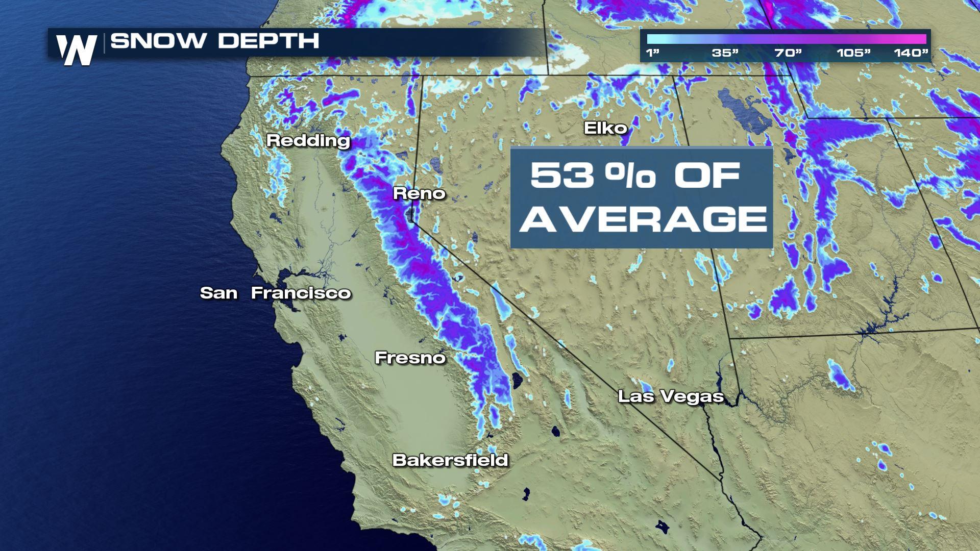
 Total snowpack increased by 10% since the end of February, from 43% to 53% of the April 1st average. The latest data from the California Department of Water Resources show the Southern Sierra is the lowest compared to average, at 45% of normal, with the Central and Northern mountains both at 56% of normal.
The season got off to a fast start before a record dry February. On January 1st, the snowpack measured in at 92% of the April 1st average, however, that number dropped to 69% by February 1st and took a massive dive thereafter.
https://twitter.com/NWSHanford/status/1244774426165440512
This is a drastic change from the same time last year, when the statewide snowpack measured in at a whopping 161% of normal. A nearly continuous stream of atmospheric river storms in March of 2019 helped to build the massive snowpack, which broke records at some reporting stations.
The latest data come from March 30th, so the numbers may still change slightly when they are updated with information from April 1st. The date is an important one, since it's when snowpack in the Sierra Nevada is typically at its peak, though that may not be the case this year (see below).
Runoff from the snowpack feeds the state's reservoirs, which are hovering between 76% and 125% of normal capacity for this time of year. A lack of water in the reservoirs has lead to water restrictions in the past.
The drier than average conditions can also lead to an increased risk of wildfires later in the year. Most of the state is experiencing abnormally dry or slight drought conditions.
Total snowpack increased by 10% since the end of February, from 43% to 53% of the April 1st average. The latest data from the California Department of Water Resources show the Southern Sierra is the lowest compared to average, at 45% of normal, with the Central and Northern mountains both at 56% of normal.
The season got off to a fast start before a record dry February. On January 1st, the snowpack measured in at 92% of the April 1st average, however, that number dropped to 69% by February 1st and took a massive dive thereafter.
https://twitter.com/NWSHanford/status/1244774426165440512
This is a drastic change from the same time last year, when the statewide snowpack measured in at a whopping 161% of normal. A nearly continuous stream of atmospheric river storms in March of 2019 helped to build the massive snowpack, which broke records at some reporting stations.
The latest data come from March 30th, so the numbers may still change slightly when they are updated with information from April 1st. The date is an important one, since it's when snowpack in the Sierra Nevada is typically at its peak, though that may not be the case this year (see below).
Runoff from the snowpack feeds the state's reservoirs, which are hovering between 76% and 125% of normal capacity for this time of year. A lack of water in the reservoirs has lead to water restrictions in the past.
The drier than average conditions can also lead to an increased risk of wildfires later in the year. Most of the state is experiencing abnormally dry or slight drought conditions.
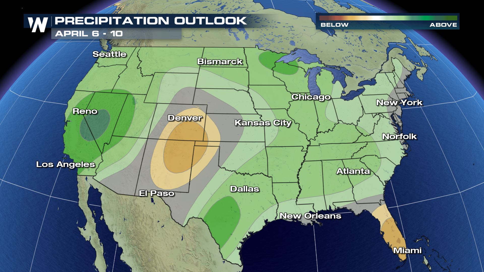 Snowpack in the Golden State may still see numbers increase through the first ten days of April. A slow moving storm system is expected to move into California this weekend and a cooler and wetter than average pattern is being favored by the Climate Prediction Center from April 6th through the 10th.
Additional information about California's snowpack, reservoirs, and stream flow forecasts can be found here.
Snowpack in the Golden State may still see numbers increase through the first ten days of April. A slow moving storm system is expected to move into California this weekend and a cooler and wetter than average pattern is being favored by the Climate Prediction Center from April 6th through the 10th.
Additional information about California's snowpack, reservoirs, and stream flow forecasts can be found here.
Total snowpack increased by 10% since the end of February, from 43% to 53% of the April 1st average. The latest data from the California Department of Water Resources show the Southern Sierra is the lowest compared to average, at 45% of normal, with the Central and Northern mountains both at 56% of normal.
The season got off to a fast start before a record dry February. On January 1st, the snowpack measured in at 92% of the April 1st average, however, that number dropped to 69% by February 1st and took a massive dive thereafter.
https://twitter.com/NWSHanford/status/1244774426165440512
This is a drastic change from the same time last year, when the statewide snowpack measured in at a whopping 161% of normal. A nearly continuous stream of atmospheric river storms in March of 2019 helped to build the massive snowpack, which broke records at some reporting stations.
The latest data come from March 30th, so the numbers may still change slightly when they are updated with information from April 1st. The date is an important one, since it's when snowpack in the Sierra Nevada is typically at its peak, though that may not be the case this year (see below).
Runoff from the snowpack feeds the state's reservoirs, which are hovering between 76% and 125% of normal capacity for this time of year. A lack of water in the reservoirs has lead to water restrictions in the past.
The drier than average conditions can also lead to an increased risk of wildfires later in the year. Most of the state is experiencing abnormally dry or slight drought conditions.
Snowpack in the Golden State may still see numbers increase through the first ten days of April. A slow moving storm system is expected to move into California this weekend and a cooler and wetter than average pattern is being favored by the Climate Prediction Center from April 6th through the 10th.
Additional information about California's snowpack, reservoirs, and stream flow forecasts can be found here. All Weather News
More
Fronts Continue To Spark Severe Weather Across the Plains
A cold front that brought record lows to the
18 Jul 2025 10:40 PM

Extreme Heat Impacts for the East Coast & South
Extreme heat continues to impact several area
18 Jul 2025 10:05 PM

Flooding Threat Remains Elevated in the East
A cold front pushing through the Eastern Seab
18 Jul 2025 9:10 PM

EF-2 Firenado from the Deer Creek Fire in Utah
A fire tornado was spotted near La Sal, Utah
18 Jul 2025 7:30 AM

Tropical System Brings Flood Risk to the Central Gulf
Time has run out for notable tropical develop
18 Jul 2025 3:05 AM

Heavy Rain, Flooding Threat Returns to Florida
Keep the rain boots handy in Florida - heavy
13 Jul 2025 12:50 PM

Severe Storm Risk Pushes into the Great Lakes, Ohio Valley
Friday was another busy day with severe weath
12 Jul 2025 8:00 PM