Some Firsts And Lasts Coming

Top Stories
25 Apr 2019 4:22 PM
From the first 100° day of the year to the last 3" snow event of the year, spring will bring quite the combination of weather the next couple of days. Let's start with Phoenix, Arizona where the city could very well have its first 100 degree day of the year on Friday.
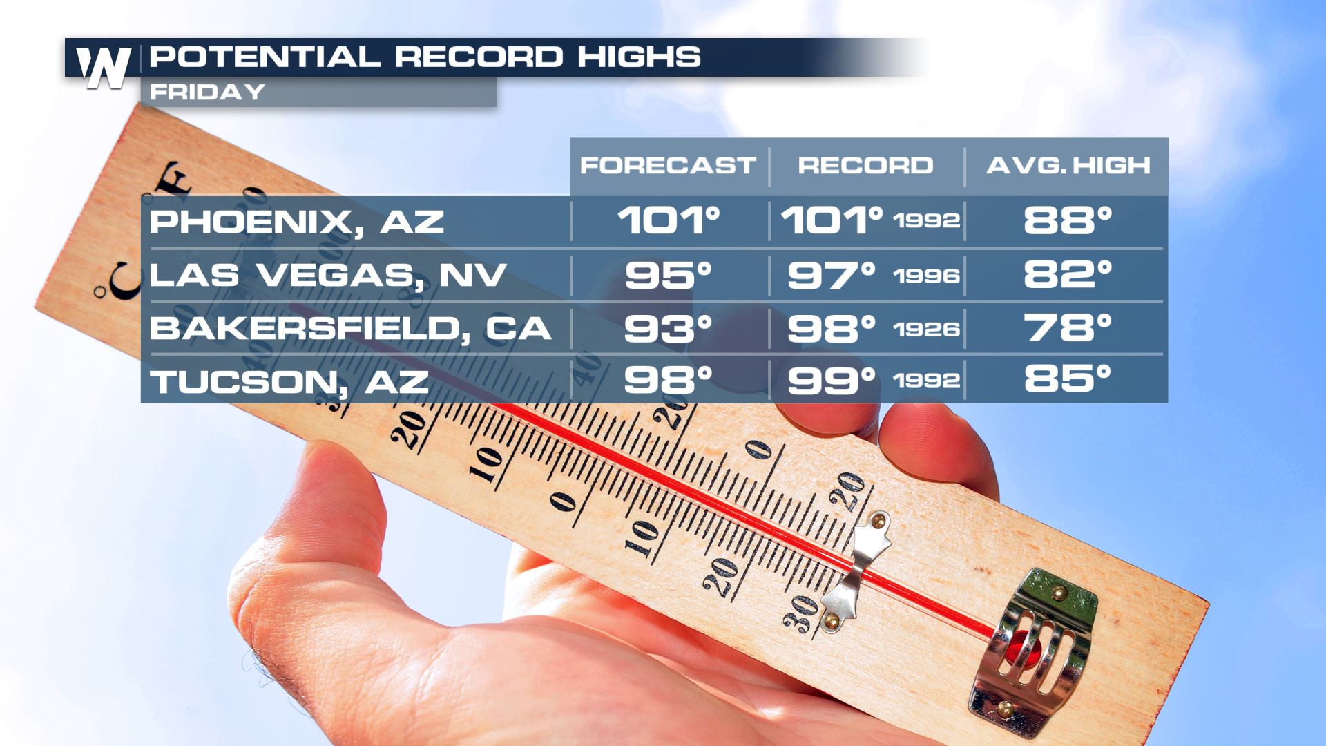 The forecast high temperatures Friday, April 26th compared to the daily record and average high.
On average Phoenix usually reaches its first 100 degree day of the year on May 11, so this could be a couple of weeks earlier-than-average. The earliest century mark happened on March 26, 1988 and the city usually gets 94 days at or above 100°!
The forecast high temperatures Friday, April 26th compared to the daily record and average high.
On average Phoenix usually reaches its first 100 degree day of the year on May 11, so this could be a couple of weeks earlier-than-average. The earliest century mark happened on March 26, 1988 and the city usually gets 94 days at or above 100°!
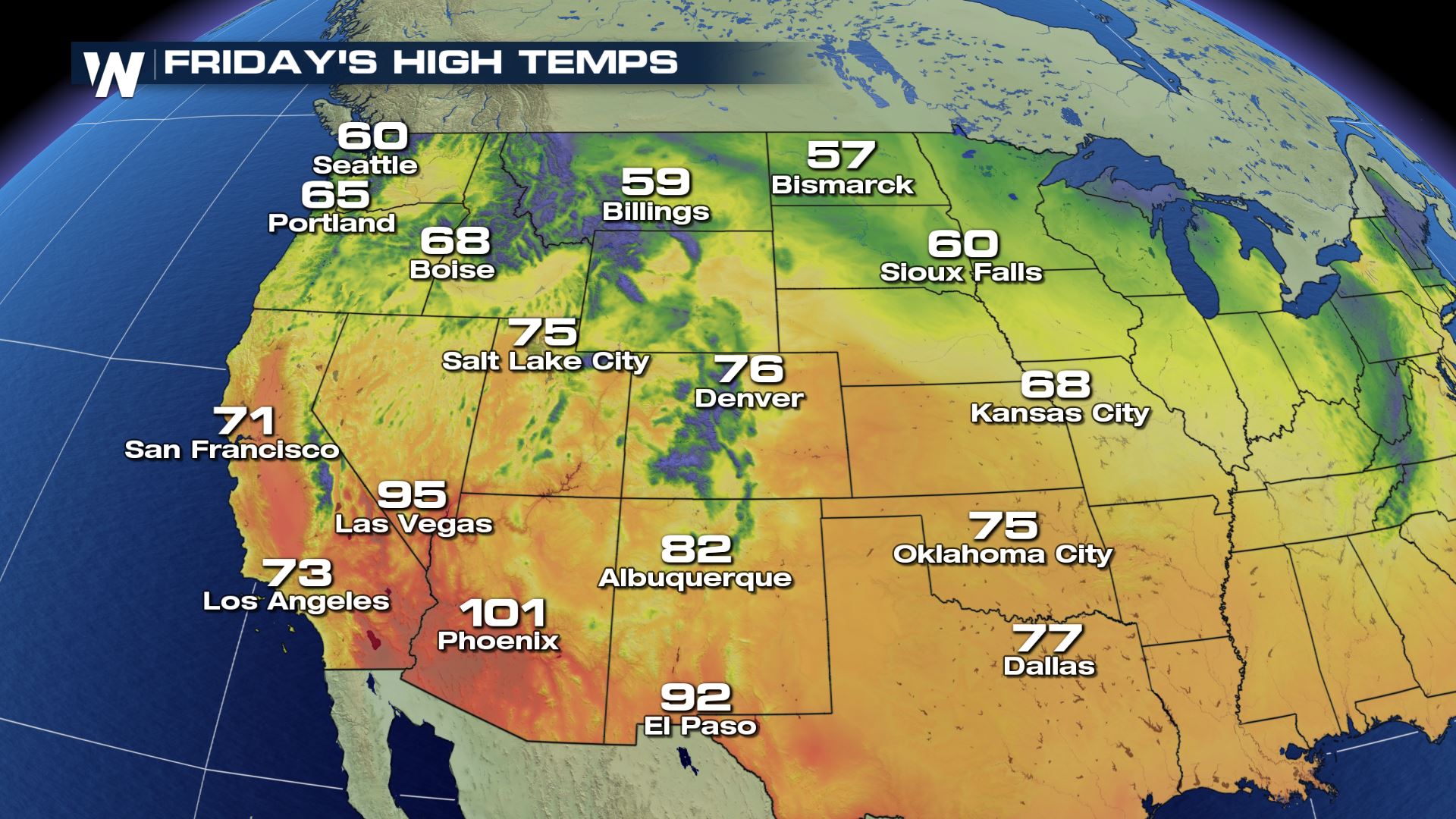 Forecast high temperatures Friday, April 26th
Much of the Southwest will be warmer-than-average Friday with anticipated high temperatures 10-15 degrees above average.
On the opposite side of the spectrum, temperatures of 10-20 degrees below average in the Upper Midwest could bring a late-season snow!
Forecast high temperatures Friday, April 26th
Much of the Southwest will be warmer-than-average Friday with anticipated high temperatures 10-15 degrees above average.
On the opposite side of the spectrum, temperatures of 10-20 degrees below average in the Upper Midwest could bring a late-season snow!
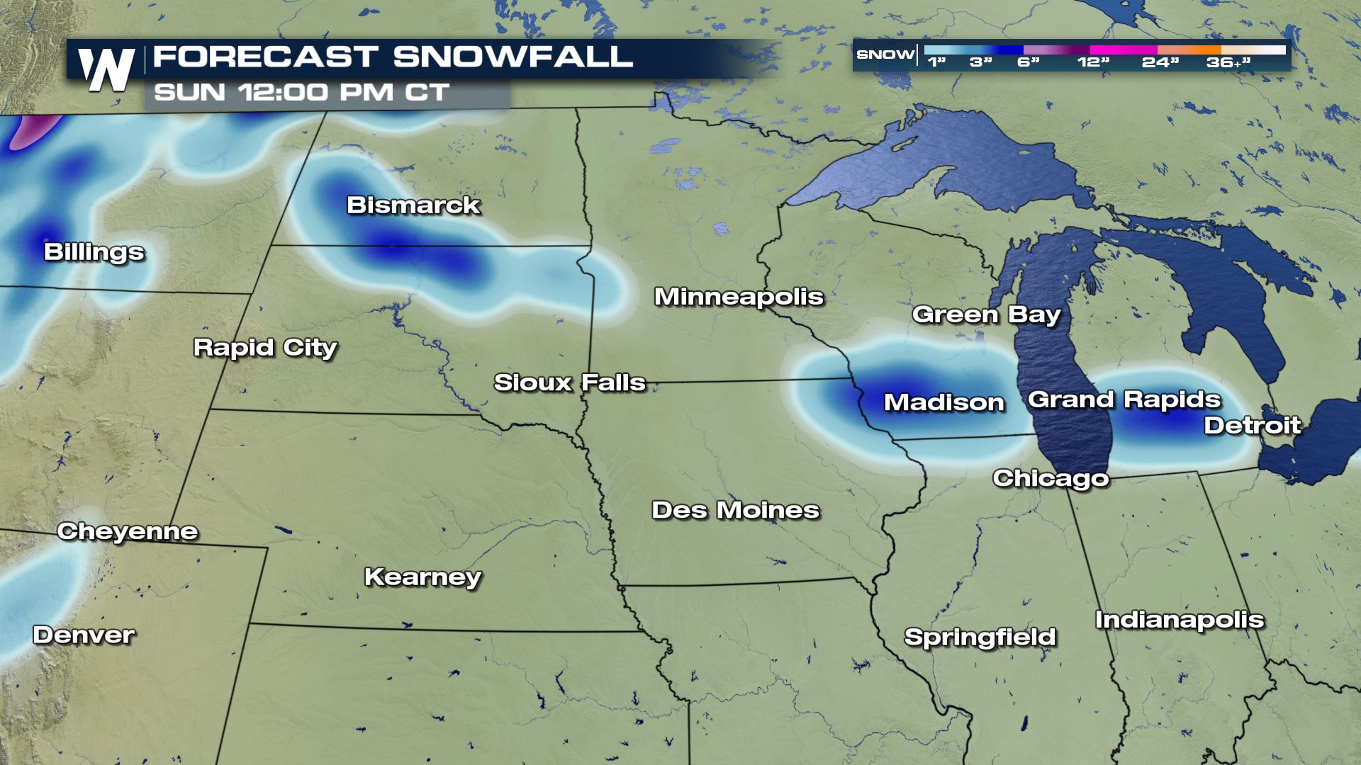 Forecast snowfall Friday night to Saturday night, April 27th-28th.
A low pressure system moving out of Montana and through the Dakotas, then to the Great Lakes will bring windy, cool and wet conditions alongside. On the northern, colder side of the storm there's a chance of accumulating snow on grassy/colder surfaces. Spring snow is difficult to accumulate on the main roadways, however watch for slushy spots Saturday and Sunday mornings when it's coolest.
Forecast snowfall Friday night to Saturday night, April 27th-28th.
A low pressure system moving out of Montana and through the Dakotas, then to the Great Lakes will bring windy, cool and wet conditions alongside. On the northern, colder side of the storm there's a chance of accumulating snow on grassy/colder surfaces. Spring snow is difficult to accumulate on the main roadways, however watch for slushy spots Saturday and Sunday mornings when it's coolest.
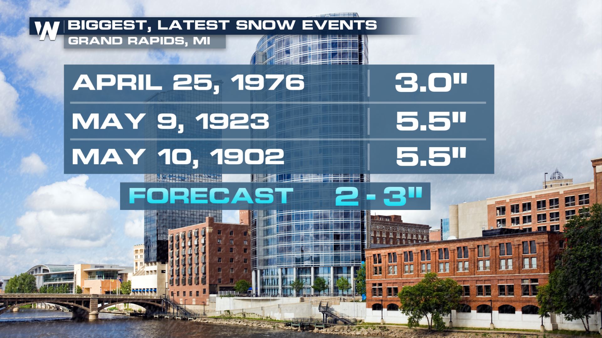 Grand Rapids, Michigan could have one of its largest, latest snow events on record!
Currently the forecast for Grand Rapids, MI is 2-3" and a snowfall of that nature has only happened a few times after today's date.
For WeatherNation, Meteorologist Steve Glazier
Grand Rapids, Michigan could have one of its largest, latest snow events on record!
Currently the forecast for Grand Rapids, MI is 2-3" and a snowfall of that nature has only happened a few times after today's date.
For WeatherNation, Meteorologist Steve Glazier
The forecast high temperatures Friday, April 26th compared to the daily record and average high.
On average Phoenix usually reaches its first 100 degree day of the year on May 11, so this could be a couple of weeks earlier-than-average. The earliest century mark happened on March 26, 1988 and the city usually gets 94 days at or above 100°!
Forecast high temperatures Friday, April 26th
Much of the Southwest will be warmer-than-average Friday with anticipated high temperatures 10-15 degrees above average.
On the opposite side of the spectrum, temperatures of 10-20 degrees below average in the Upper Midwest could bring a late-season snow!
Forecast snowfall Friday night to Saturday night, April 27th-28th.
A low pressure system moving out of Montana and through the Dakotas, then to the Great Lakes will bring windy, cool and wet conditions alongside. On the northern, colder side of the storm there's a chance of accumulating snow on grassy/colder surfaces. Spring snow is difficult to accumulate on the main roadways, however watch for slushy spots Saturday and Sunday mornings when it's coolest.
Grand Rapids, Michigan could have one of its largest, latest snow events on record!
Currently the forecast for Grand Rapids, MI is 2-3" and a snowfall of that nature has only happened a few times after today's date.
For WeatherNation, Meteorologist Steve GlazierAll Weather News
More
More Storms for the East Through Monday
The threat for flooding rain continues across
3 Aug 2026 6:00 PM


After Reaching Category 5, Genevieve Weakens in the Pacific
PacificGenevieve formed last Friday south of
3 Aug 2026 12:30 AM

Flooding, Severe Storms Target the Midwest Again
After an active week of storms across the nor
1 Aug 2026 1:40 AM

Flooding Risk Increases as Heavy Rain Targets the Tri-State Area
Tuesday, heavy rainfall moved across the Nort
30 Jul 2026 12:25 AM