Something about Lions, Lambs, Flowers and Showers in the Plains
Special Stories
23 May 2019 6:30 AM
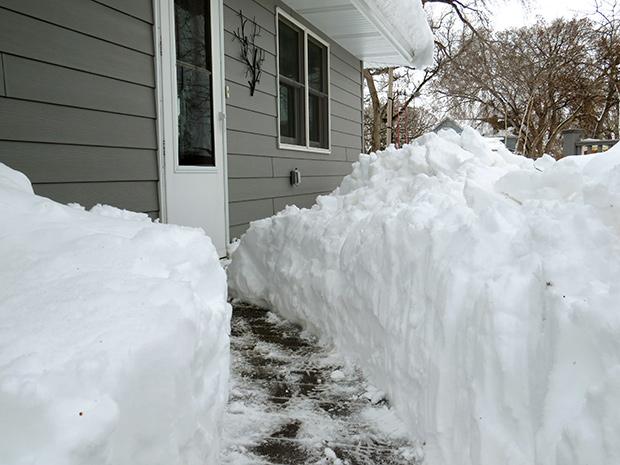
[Following a late winter storm, shoveling the sidewalk created a snow tunnel in front of a South Dakota house on April 12, 2019. From Kelly Preheim on flickr via NOAA]
[NOAA by Deke Arndt] Borrowing one of meteorology’s great euphemisms, this spring has been “an active one” in much of the country. The Plains and Upper Midwest experienced huge events in back-to-back months. March brought an explosive winter storm to much of the region, and a cascade of events that led to historic flooding from Nebraska to Wisconsin. April gave us a more canonical blizzard, a winter storm with snowfall measured in feet.
So what happened? How does this fit into history? How does April bring the huge storms? Some answers follow. Let’s go Beyond the Data.
The March Cyclone and Floods
Understanding what happened in March requires going back several weeks in time to examine the conditions that contributed to the flooding. It’s important to note that late winter was very snowy and cold across the region. How snowy? February snow cover across the contiguous U.S. was larger than the average footprint by more than a third of average. To quote NCEI’s National Snow & Ice report:According to NOAA data analyzed by the Rutgers Global Snow Lab, the monthly snow cover across the contiguous U.S. was 1.63 million square miles, which is 432,800 square miles above the 1981-2010 average. This was the 4th-largest February snow cover extent in the 53-year satellite record and the largest since 2010.
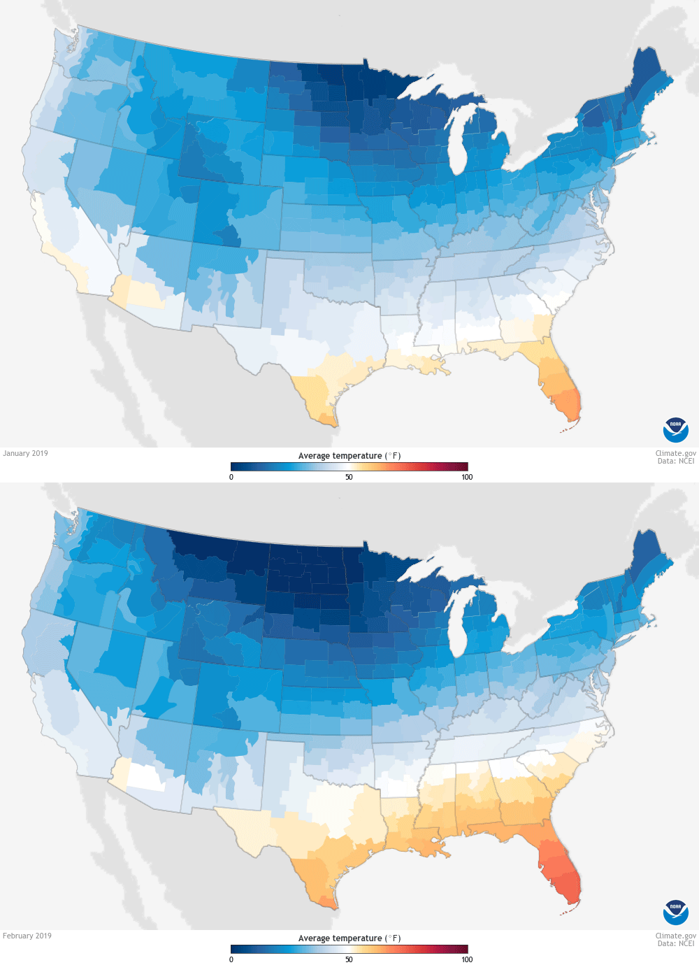
[Across much of the Northern Plains, January 2019 temperatures were warmer than February's. NOAA Climate image, based on NCEI data.]
How cold? February was colder than January, if that helps put it into perspective. More importantly, afternoons were particularly cold. By this measure, February 2019 was the second-coldest February on record for several northern states and among the top ten for all of them. In Nebraska, the average maximum temperature (the daytime high) was 27 degrees F. The Dakotas and Minnesota numbers are even colder—probably unmentionable in polite company.
If the average daytime high temperature for the month was below freezing, that means the vast, vast majority of the month was spent below freezing. This means, in turn, that the soils there were frozen to a significant depth—and a few inches is significant enough. Soils that are frozen can absorb no water. Water that isn’t absorbed into the soil runs off above the surface.
You see where I’m going here: The late winter brought frozen soils, and a deep blanket of snow to the region. Add a couple of late winter storms including a giant “bomb cyclone” that pulled in warm, moist air and heavy rains on their front flank, and you literally have a recipe for disaster.
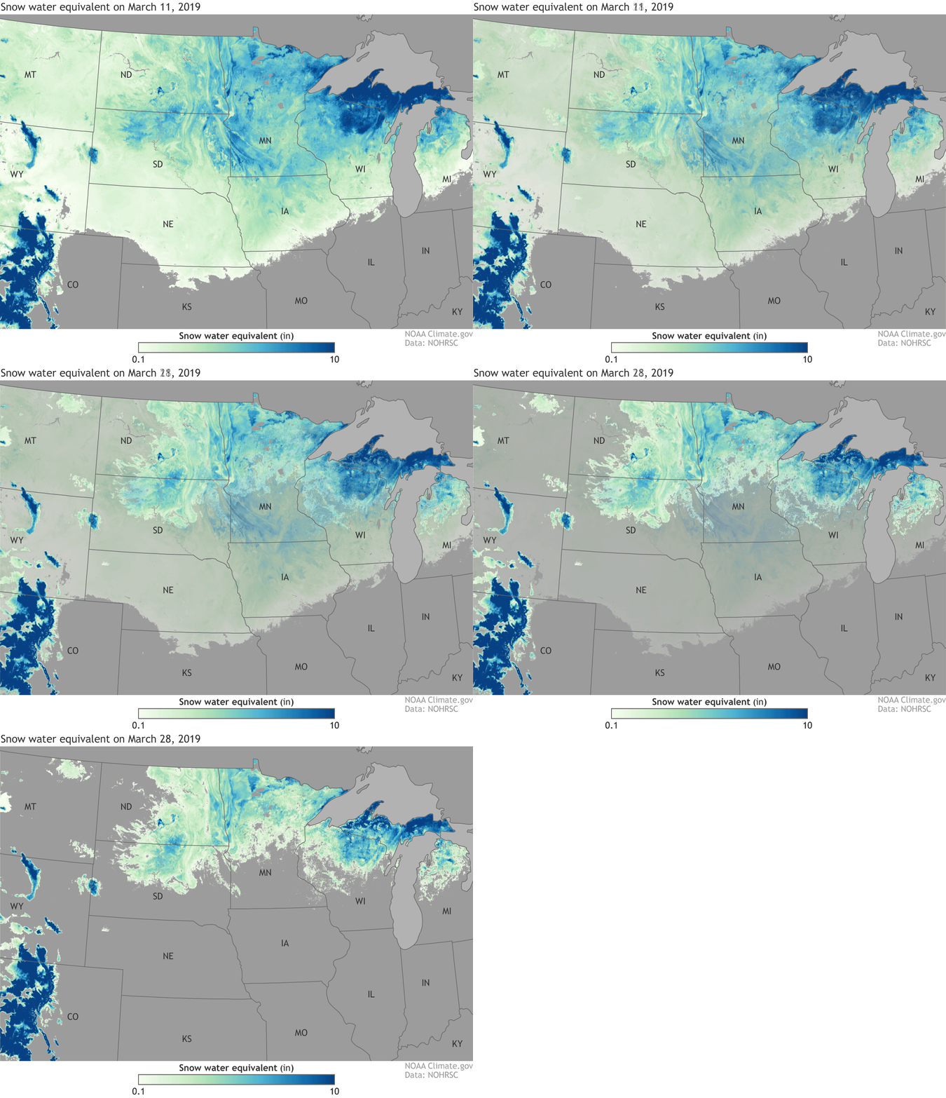 [The amount of water contained in the snowpack across the Northern Plains on March 11 and 28, 2019, based on observations and models. In mid-March, a deep snowpack (dark blues) held 4-10 inches of liquid water in South Dakota, Minnesota, Iowa, and Wisconsin. By the end of March, much of it had melted and inundated the still-frozen ground, delivering a massive pulse of floodwater into area rivers. NOAA Climate image using data from NOHRSC.]
Heavy rain on snow melts snow—quickly. With an impervious (i.e., frozen) surface underneath, there’s nowhere for all of the rain and melted snow to go but over the land. Creeks fed streams, streams fed rivers, rivers escaped their confines, ice jams pooled and dosed raging flood waters, levees failed.
It was a disaster of epic proportions. But like many disasters, natural and in our own lives, it was the set-up, not the trigger, that fed the magnitude.
[The amount of water contained in the snowpack across the Northern Plains on March 11 and 28, 2019, based on observations and models. In mid-March, a deep snowpack (dark blues) held 4-10 inches of liquid water in South Dakota, Minnesota, Iowa, and Wisconsin. By the end of March, much of it had melted and inundated the still-frozen ground, delivering a massive pulse of floodwater into area rivers. NOAA Climate image using data from NOHRSC.]
Heavy rain on snow melts snow—quickly. With an impervious (i.e., frozen) surface underneath, there’s nowhere for all of the rain and melted snow to go but over the land. Creeks fed streams, streams fed rivers, rivers escaped their confines, ice jams pooled and dosed raging flood waters, levees failed.
It was a disaster of epic proportions. But like many disasters, natural and in our own lives, it was the set-up, not the trigger, that fed the magnitude.
[The amount of water contained in the snowpack across the Northern Plains on March 11 and 28, 2019, based on observations and models. In mid-March, a deep snowpack (dark blues) held 4-10 inches of liquid water in South Dakota, Minnesota, Iowa, and Wisconsin. By the end of March, much of it had melted and inundated the still-frozen ground, delivering a massive pulse of floodwater into area rivers. NOAA Climate image using data from NOHRSC.]
Heavy rain on snow melts snow—quickly. With an impervious (i.e., frozen) surface underneath, there’s nowhere for all of the rain and melted snow to go but over the land. Creeks fed streams, streams fed rivers, rivers escaped their confines, ice jams pooled and dosed raging flood waters, levees failed.
It was a disaster of epic proportions. But like many disasters, natural and in our own lives, it was the set-up, not the trigger, that fed the magnitude.
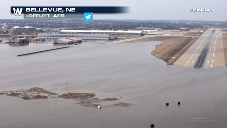
[A lake of floodwater covered a runway and other parts of Nebraska's Offutt Air Force Base on March 17, 2019. U.S. Air Force photo by Tech. Sgt. Rachelle Blake.]
April Snowstorm
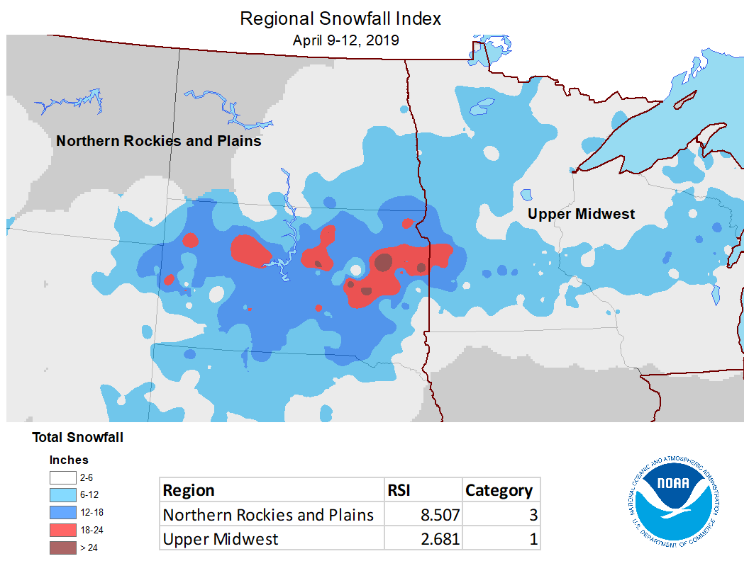
Winter wasn’t done walloping the Midwest, though. A late-season snowstorm, centered on South Dakota, brought some pretty massive snowfall totals to the Northern Plains and Upper Midwest. More than two feet fell at Watertown, South Dakota, with foot-plus totals stretching from eastern Colorado to Lake Superior. This storm rated as a Category 3 for the Northern Plains in NOAA’s Regional Snow Index, and a Category 1 storm for the Upper Midwest. The RSI combines two sets of factors: first, the area (“footprint”) and depth of snow, and second, the location of populated areas in the region. It’s “tuned” to both factors historically: the area and depth of snows are compared to those of the region’s history, and population centers are scaled accordingly as well. The RSI rating in the Northern Plains was the largest since the Blizzard of October 2013. But wait, April? October? Is it unusual to have huge snow events in these “shoulder” months, which, in most years, we don’t associate with winter weather?The short answer: these shoulder months are winter’s secret weapons. A quick scroll through each county’s historical storms of record will reveal a large number of October/November and March/April dates for northern counties, and even some May dates (yeesh!) for high-altitude Rocky Mountain counties.
[Snowfall and Regional Snowfall Index values associated with the April 2019 blizzard.]
The reason for this is straightforward: a warmer atmosphere can “hold” more water vapor, and therefore deliver more water vapor to a storm, which converts it into more precipitation. It is a pretty comfortable relationship when you think of it in terms of rain, but it’s true for snow, too. A winter storm working on saturated 30-degree F air is going to make more snow than a winter storm working on saturated 10-degree F air.
This is why these “shoulder" months produce a disproportionate share of legendary snow-making storms. It’s thermodynamics. They are working with much warmer air, typically, even if it’s still just below freezing.
Coda: Epic Flooding
Going back to the March flooding event, floods are complex. They involve a system of factors beyond precipitation:- the (literal) shape of the terrain,
- the dryness or saturation of soils,
- which works the dial on how much precipitation runs off,
- whether frozen soil or other impervious surfaces turn that dial to “11,”
- how dams and waterways are managed,
- how these management structures work, and so on.
Edited for WeatherNation by Meteorologist Mace Michaels
All Weather News
More
SW Low Moves East, Brings Flood Threat to the Plains
A powerful low pressure system has been movin
23 Oct 2026 2:00 PM

Hurricane Vance Strengthens In The Pacific
Hurricane Vance continues to strengthen in th
23 Oct 2026 1:00 PM

Warmer Than Average: Above-Normal Temperatures Across the Central U.S. This Week
WHAT TO EXPECTA ridge of high pressure linger
23 Oct 2026 1:00 PM


Several Fires Break Out in SoCal Last Week Amid Santa Ana Wind Event
Santa Ana winds helped several fires grow qui
19 Oct 2026 1:25 PM

Another Cold Morning Before Things Warm Back Up
Across portions of the Ohio Valley through th
19 Oct 2026 10:15 AM

Severe Risk Diminishing Saturday Morning for the Northeast
Severe Storm PotentialSevere risk is decreasi
16 Oct 2026 10:20 AM