Southeast Seeing Threats From Heavy Rain and Severe Storms Today
Special Stories
14 Dec 2018 11:40 AM
A vigorous storm system is plowing through the southeast today. Several inches of rain are expected, along with a threat of severe storms. Parts of the southeast were drenched with rain earlier this week. So this round of showers is falling on top of saturated soil. And there is still snow on the ground in parts of North Carolina and Virginia. So additional rain will melt the snow, possibly leading to flooding.
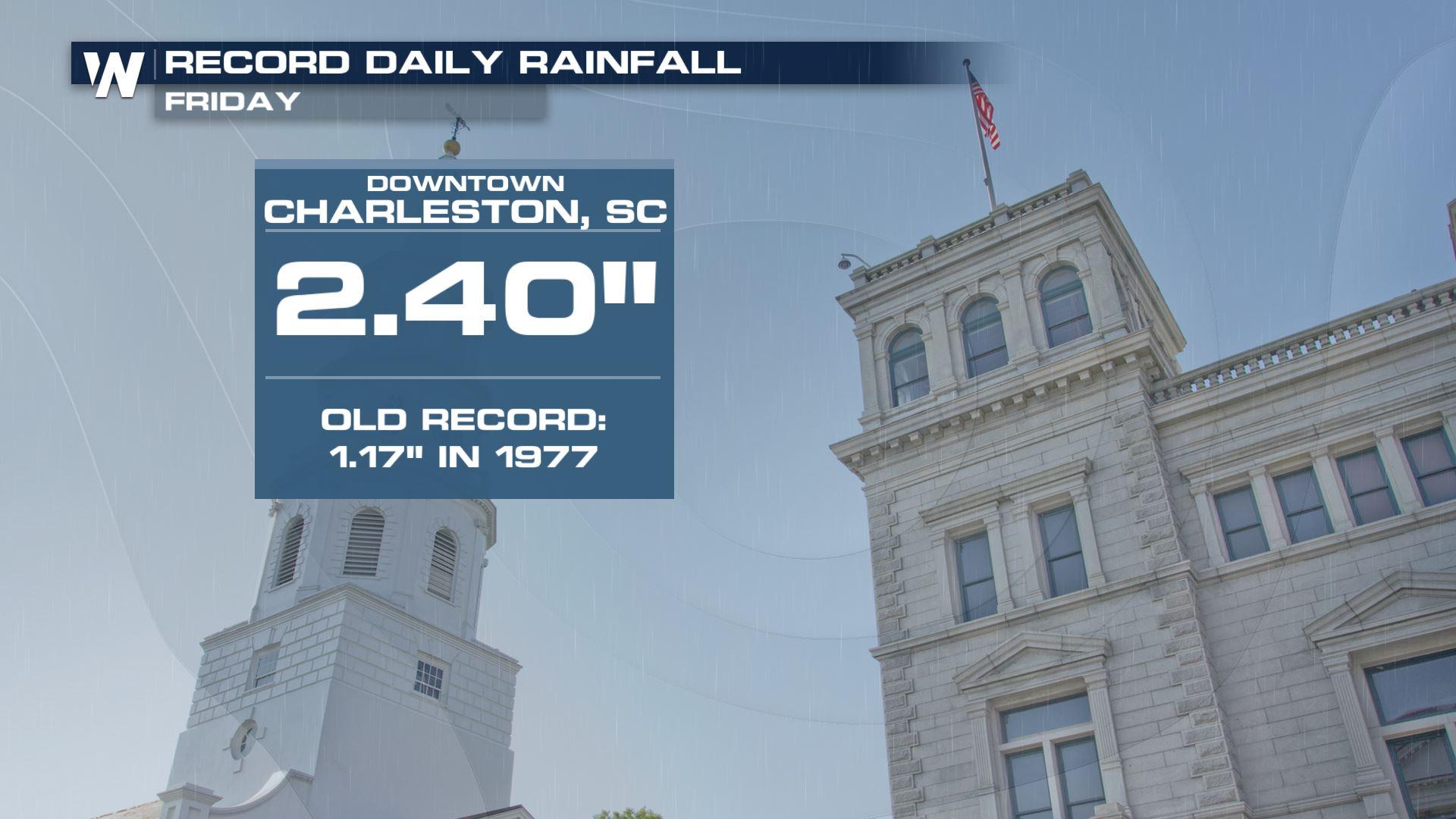
Charleston, SC set a daily record for rainfall today with 2.40 inches. And the rain is far from over!
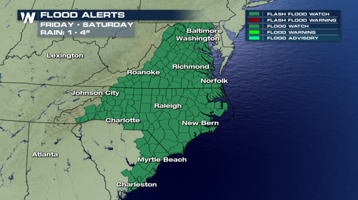
Flash Flood Watches are up for the rest of today, and most of Saturday from Charleston and Myrtle Beach, through most of North Carolina and Virginia, and into the Baltimore and Washington D.C. areas. One to four inches of rain are possible from the storm.
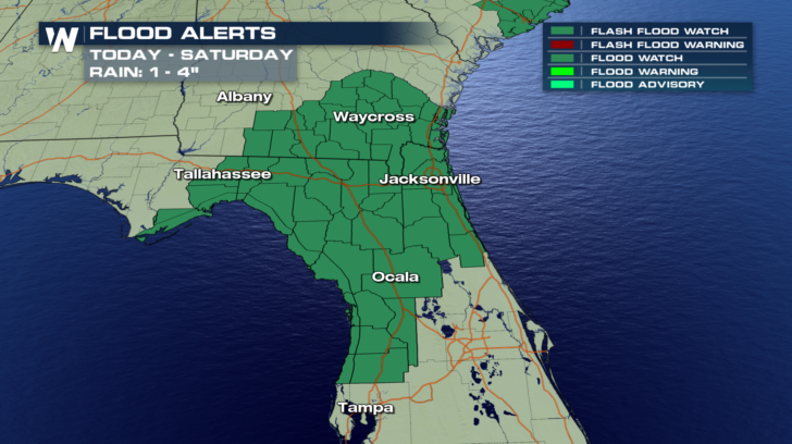
 Farther to the south, Flash Flood Watches are also in effect for today and Saturday in southern Georgia and northern Florida. Similar rain totals of one to four inches are possible there.
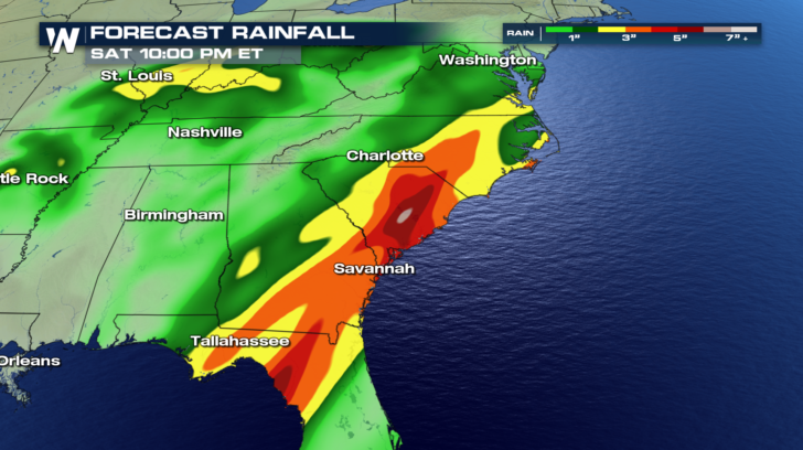
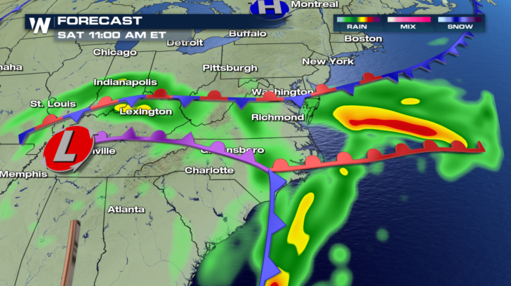
 You can see where the heaviest rain is expected through Saturday night. The yellow, orange, and red areas, indicate a swath of rain between 2 and 4 inches. It appears that parts of eastern South Carolina could see up to 6 inches of rain!
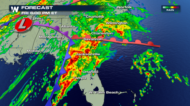
 Look at the action in the southeast Friday afternoon. There's a lot of energy with this system, especially where the three fronts come together. Where the cold front, warm front, and occluded front intersect, is an area of significant atmospheric turbulence. It's called a triple point, and usually creates a higher risk for severe weather.
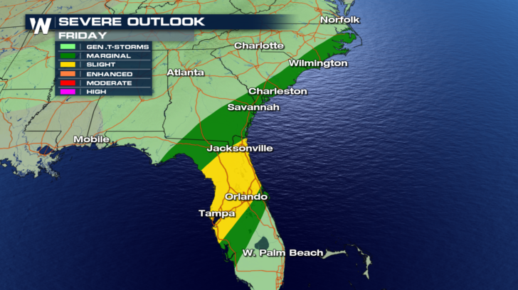
 Severe weather will be a distinct possibility today. The green shaded area has a "Marginal" Risk, about a 5 percent chance of strong to severe storms. There's actually a higher risk of severe weather in the "Slight" Risk area, shaded in yellow, about 15 percent. This area includes central and northern Florida. Jacksonville, Tampa, and Orlando are all in this "Slight" risk area.
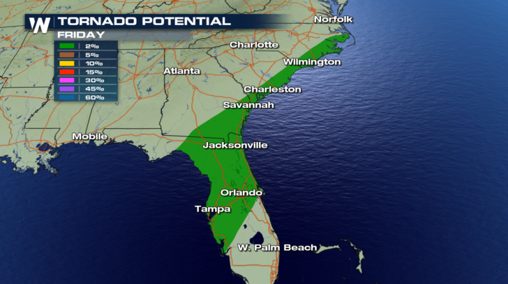
 The risks today include tornadoes and damaging straight line winds over 58 mph.
The threat of tornadoes is not particularly high today. However, a few isolated tornadoes are possible. It's a threat that must be taken seriously, and watched very carefully throughout the day. Waterspouts will also be possible in the Atlantic and the Gulf of Mexico.
The risks today include tornadoes and damaging straight line winds over 58 mph.
The threat of tornadoes is not particularly high today. However, a few isolated tornadoes are possible. It's a threat that must be taken seriously, and watched very carefully throughout the day. Waterspouts will also be possible in the Atlantic and the Gulf of Mexico.
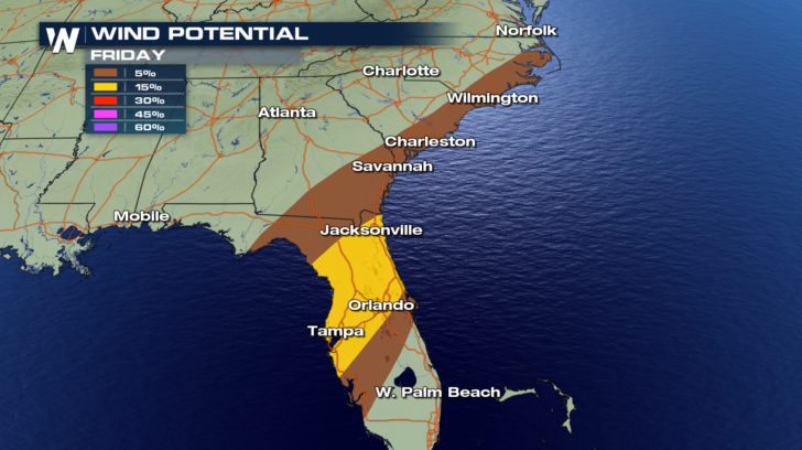
 The risk of damaging straight-line winds is higher than tornadoes. There will be a 5 percent chance of storms producing winds over 58 mph in the brown shaded areas. There will be a 15 percent chance of damaging winds in the yellow shaded area.
 On Saturday, Georgia and Alabama will begin to dry out by the late morning, as the majority of the rain moves north and northeast. The triple point area will be located in eastern North Carolina. Severe weather will be possible in this area.
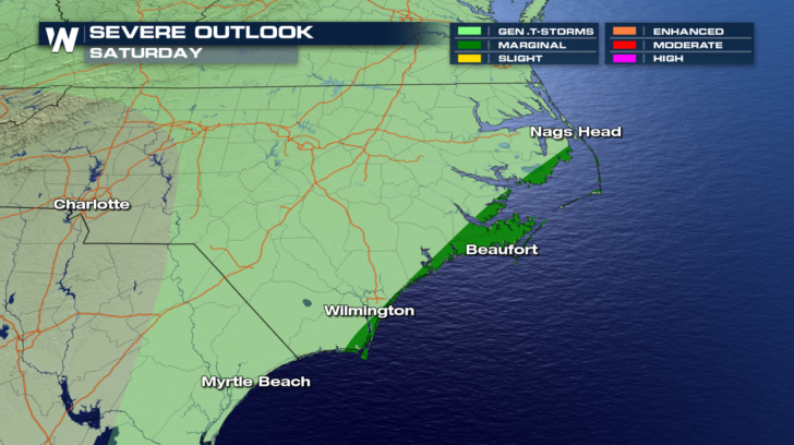
 The severe weather threat will be confined to the immediate coastal sections of North Carolina. It's a Marginal Risk, a 5 percent chance, and extends from Wilmington, through Beaufort, and up the coast into the Nags Head area.
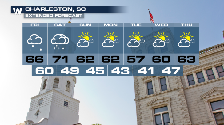
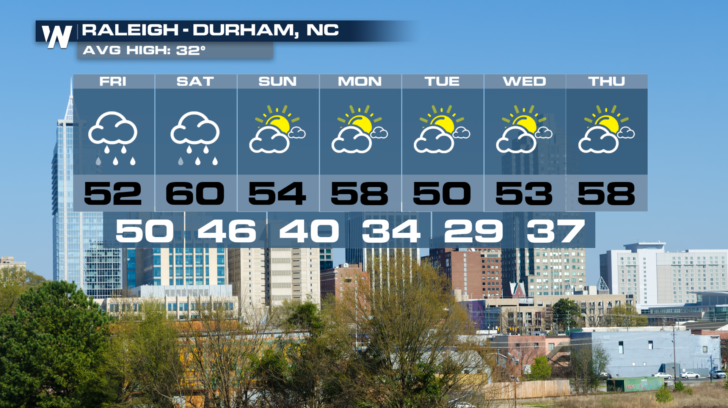
 If you live in this part of the country, hang in there! Better weather is on the way! Check out the forecasts for Charleston and Raleigh-Durham. Soggy weather is expected today, and again tomorrow. But after that, amazing weather will be back in both towns. Charleston looks fantastic right through at least Thursday of next week, with highs near 60 each day. Raleigh-Durham will be equally as beautiful with slightly cooler temps in the 50's.
 Stay tuned to WeatherNation for the very latest information on this southern storm. You can watch on the Dish Network, Fire TV, Roku, and Apple TV.
For WeatherNation: Meteorologist Matt Monroe
Stay tuned to WeatherNation for the very latest information on this southern storm. You can watch on the Dish Network, Fire TV, Roku, and Apple TV.
For WeatherNation: Meteorologist Matt Monroe
Farther to the south, Flash Flood Watches are also in effect for today and Saturday in southern Georgia and northern Florida. Similar rain totals of one to four inches are possible there.
You can see where the heaviest rain is expected through Saturday night. The yellow, orange, and red areas, indicate a swath of rain between 2 and 4 inches. It appears that parts of eastern South Carolina could see up to 6 inches of rain!
Look at the action in the southeast Friday afternoon. There's a lot of energy with this system, especially where the three fronts come together. Where the cold front, warm front, and occluded front intersect, is an area of significant atmospheric turbulence. It's called a triple point, and usually creates a higher risk for severe weather.
Severe weather will be a distinct possibility today. The green shaded area has a "Marginal" Risk, about a 5 percent chance of strong to severe storms. There's actually a higher risk of severe weather in the "Slight" Risk area, shaded in yellow, about 15 percent. This area includes central and northern Florida. Jacksonville, Tampa, and Orlando are all in this "Slight" risk area.
The risks today include tornadoes and damaging straight line winds over 58 mph.
The threat of tornadoes is not particularly high today. However, a few isolated tornadoes are possible. It's a threat that must be taken seriously, and watched very carefully throughout the day. Waterspouts will also be possible in the Atlantic and the Gulf of Mexico.
The risk of damaging straight-line winds is higher than tornadoes. There will be a 5 percent chance of storms producing winds over 58 mph in the brown shaded areas. There will be a 15 percent chance of damaging winds in the yellow shaded area.
On Saturday, Georgia and Alabama will begin to dry out by the late morning, as the majority of the rain moves north and northeast. The triple point area will be located in eastern North Carolina. Severe weather will be possible in this area.
The severe weather threat will be confined to the immediate coastal sections of North Carolina. It's a Marginal Risk, a 5 percent chance, and extends from Wilmington, through Beaufort, and up the coast into the Nags Head area.
If you live in this part of the country, hang in there! Better weather is on the way! Check out the forecasts for Charleston and Raleigh-Durham. Soggy weather is expected today, and again tomorrow. But after that, amazing weather will be back in both towns. Charleston looks fantastic right through at least Thursday of next week, with highs near 60 each day. Raleigh-Durham will be equally as beautiful with slightly cooler temps in the 50's.
Stay tuned to WeatherNation for the very latest information on this southern storm. You can watch on the Dish Network, Fire TV, Roku, and Apple TV.
For WeatherNation: Meteorologist Matt MonroeAll Weather News
More
Wildfire Outbreak in the Pacific Northwest
SPOKANE, WA - On Saturday, August 1st, the Ol
3 Aug 2026 1:55 AM

More Storms for the East Through Monday
A low-pressure system that moved through the
3 Aug 2026 1:50 AM


After Reaching Category 5, Genevieve Weakens in the Pacific
PacificGenevieve formed last Friday south of
3 Aug 2026 12:30 AM

Flooding, Severe Storms Target the Midwest Again
After an active week of storms across the nor
1 Aug 2026 1:40 AM

Flooding Risk Increases as Heavy Rain Targets the Tri-State Area
Tuesday, heavy rainfall moved across the Nort
30 Jul 2026 12:25 AM

Severe Weather: Energy From the Midwest Now in the Southeast
UPPER MIDWEST - Through Monday, dangerous tor
29 Jul 2026 10:30 PM