Spider Lightning Seen From Space by GOES East
Special Stories
16 Apr 2018 3:12 PM
From NOAA
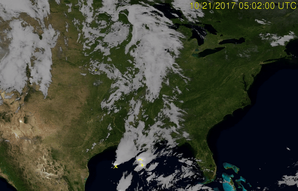
When you spend 24/7/365 staring at Earth, you see some strange things. The NOAA GOES East satellite (GOES-16) witnessed a spectacular display of stratiform, or ‘spider’ lightning as it’s known, in October over the Central Plains.
The GOES-R series of satellites (which includes GOES-16 and the recently launched GOES-17) are equipped with the new Geostationary Lightning Mapper - GLM - technology, allowing the satellite to capture imagery of lightning as never seen before. Check out this video to see the prolific spider lightning erupt over multiple states over several hours.
The video above is from a storm system last October that produced extensive stratiform (or spider) lightning behind the main convective line. This lightning connected vast regions of opposite charge within the thunderstorm clouds. These extensive lightning flashes often simultaneously strike the ground in multiple places miles apart. They also are known to trigger upward lightning from tall objects.The imagery in this video was created using snapshots from the satellite taken over the same location every five minutes.
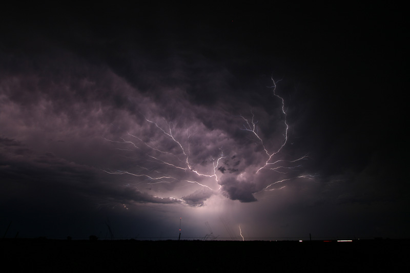 Ground photograph of 'Spider Lightning'
These flashes are called spider lightning due to the pattern they create when they quickly creep and crawl from one cloud to another. These long, horizontally traveling flashes can be seen from Earth below the clouds when they are especially strong and bright. GOES East, along with the recently launched GOES-17 satellite, can ‘see’ the lightning flashes all the way from their orbital position 22,000 miles above the surface of the Earth using the GLM instrument.
The GLM continually looks for lightning flashes in the Western Hemisphere. Along with the ABI instrument, the flash density can help forecasters observe the formation and intensification of storms. Rapid increases of lightning are a signal that a storm is strengthening quickly and could produce severe weather. During heavy rain, GLM data can show when thunderstorms are stalled or if they are gathering strength. When combined with radar and other satellite data from geostationary and polar satellites, GLM data may help forecasters anticipate severe weather and issue flood and flash flood warnings sooner. In dry areas, especially in the western United States, information from the instrument will help forecasters, and ultimately firefighters, identify areas prone to wildfires sparked by lightning.
Ground photograph of 'Spider Lightning'
These flashes are called spider lightning due to the pattern they create when they quickly creep and crawl from one cloud to another. These long, horizontally traveling flashes can be seen from Earth below the clouds when they are especially strong and bright. GOES East, along with the recently launched GOES-17 satellite, can ‘see’ the lightning flashes all the way from their orbital position 22,000 miles above the surface of the Earth using the GLM instrument.
The GLM continually looks for lightning flashes in the Western Hemisphere. Along with the ABI instrument, the flash density can help forecasters observe the formation and intensification of storms. Rapid increases of lightning are a signal that a storm is strengthening quickly and could produce severe weather. During heavy rain, GLM data can show when thunderstorms are stalled or if they are gathering strength. When combined with radar and other satellite data from geostationary and polar satellites, GLM data may help forecasters anticipate severe weather and issue flood and flash flood warnings sooner. In dry areas, especially in the western United States, information from the instrument will help forecasters, and ultimately firefighters, identify areas prone to wildfires sparked by lightning.
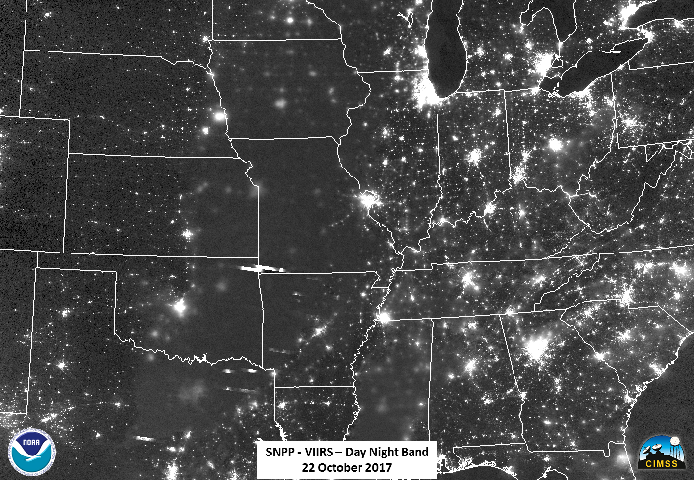 NOAA GOES East wasn’t the only satellite in our fleet to capture this rare event shown above. The Day Night Band on board the polar orbiting NOAA/NASA Suomi NPP Satellite (*note this event occurred just before our new polar orbiting NOAA-20 satellite launched) was also able to observe lighting during this event. The Day Night Band can detect lightning flashes, which appear as bright streaks atop a nocturnal storm. While the DNB can’t detect how much lightning is happening, depending on the lightning flash rate of a storm, there is a chance that the Day Night Band might capture the in-cloud scattered light. Suomi NPP was able to capture these spider lightning strikes due to their extent and prolonged duration.
Edited for WeatherNation by Meteorologist Mace Michaels
NOAA GOES East wasn’t the only satellite in our fleet to capture this rare event shown above. The Day Night Band on board the polar orbiting NOAA/NASA Suomi NPP Satellite (*note this event occurred just before our new polar orbiting NOAA-20 satellite launched) was also able to observe lighting during this event. The Day Night Band can detect lightning flashes, which appear as bright streaks atop a nocturnal storm. While the DNB can’t detect how much lightning is happening, depending on the lightning flash rate of a storm, there is a chance that the Day Night Band might capture the in-cloud scattered light. Suomi NPP was able to capture these spider lightning strikes due to their extent and prolonged duration.
Edited for WeatherNation by Meteorologist Mace Michaels
Ground photograph of 'Spider Lightning'
These flashes are called spider lightning due to the pattern they create when they quickly creep and crawl from one cloud to another. These long, horizontally traveling flashes can be seen from Earth below the clouds when they are especially strong and bright. GOES East, along with the recently launched GOES-17 satellite, can ‘see’ the lightning flashes all the way from their orbital position 22,000 miles above the surface of the Earth using the GLM instrument.
The GLM continually looks for lightning flashes in the Western Hemisphere. Along with the ABI instrument, the flash density can help forecasters observe the formation and intensification of storms. Rapid increases of lightning are a signal that a storm is strengthening quickly and could produce severe weather. During heavy rain, GLM data can show when thunderstorms are stalled or if they are gathering strength. When combined with radar and other satellite data from geostationary and polar satellites, GLM data may help forecasters anticipate severe weather and issue flood and flash flood warnings sooner. In dry areas, especially in the western United States, information from the instrument will help forecasters, and ultimately firefighters, identify areas prone to wildfires sparked by lightning.
NOAA GOES East wasn’t the only satellite in our fleet to capture this rare event shown above. The Day Night Band on board the polar orbiting NOAA/NASA Suomi NPP Satellite (*note this event occurred just before our new polar orbiting NOAA-20 satellite launched) was also able to observe lighting during this event. The Day Night Band can detect lightning flashes, which appear as bright streaks atop a nocturnal storm. While the DNB can’t detect how much lightning is happening, depending on the lightning flash rate of a storm, there is a chance that the Day Night Band might capture the in-cloud scattered light. Suomi NPP was able to capture these spider lightning strikes due to their extent and prolonged duration.
Edited for WeatherNation by Meteorologist Mace MichaelsAll Weather News
More
Fronts Continue To Spark Severe Weather Across the Plains
A cold front that brought record lows to the
18 Jul 2025 10:40 PM

Extreme Heat Impacts for the East Coast & South
Extreme heat continues to impact several area
18 Jul 2025 10:05 PM

Flooding Threat Remains Elevated in the East
A cold front pushing through the Eastern Seab
18 Jul 2025 9:10 PM

EF-2 Firenado from the Deer Creek Fire in Utah
A fire tornado was spotted near La Sal, Utah
18 Jul 2025 7:30 AM

Tropical System Brings Flood Risk to the Central Gulf
Time has run out for notable tropical develop
18 Jul 2025 3:05 AM

Heavy Rain, Flooding Threat Returns to Florida
Keep the rain boots handy in Florida - heavy
13 Jul 2025 12:50 PM

Severe Storm Risk Pushes into the Great Lakes, Ohio Valley
Friday was another busy day with severe weath
12 Jul 2025 8:00 PM