Spring Stats - A Look Back the Warmest, Wettest, Driest and Coldest of the Past
Special Stories
13 Mar 2018 3:56 PM
From NOAA by Deke Arndt
With Spring just around the corner, let’s look back across the nation’s modern climate history, which dates to 1895, the second Grover Cleveland administration. One of the intermittent features of the NOAA supplemental State of the Climate information is the “when was your warmest/coolest/wettest/driest season on record?” For example, when was your warmest spring on record? Here’s a map. There are six colors: the first five show the springs with the five largest footprints of “warmest spring on record.” The sixth color is "Other” which means “we only used five crayons. The other regions are really small.”
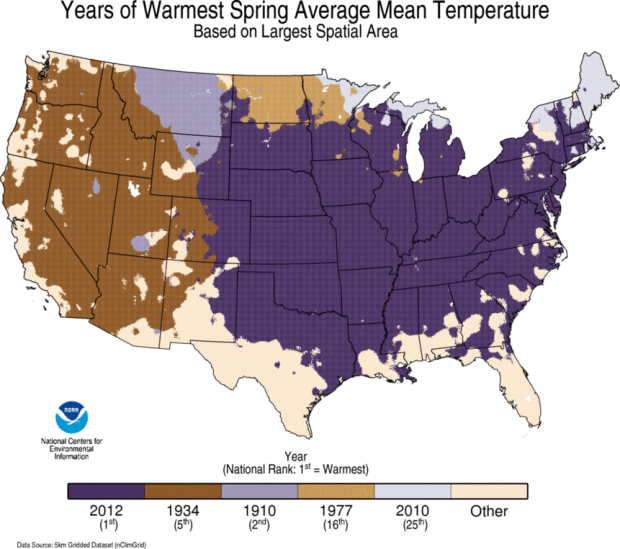 [Warmest Spring on record, since 1895, based on average temperature, for each 5km-by-5km pixel in the contiguous United States. The five Springs with the largest footprint are depicted on this map. Please note that the five largest footprints are not necessarily the five warmest Springs, on average.]
For almost half of the CONUS (49.0%), and most of the CONUS east of the Rockies, the answer is “2012.” That was an epically warm spring. For about half of the rest (25.0%), most of the CONUS west of the Rockies, the answer is “1934.”
If you’re wondering whether just two seasons uniformly covering up three-fourths of the map is unusual, it is. Most maps are more fractured than this. But it underscores one tenet of weather and climate: hot is big. The features that make things warm - ridges, namely - tend to be big and slow.
Moving onto a variant of the same map, here’s a map that shows the same thing, but strictly for daily maximum (“afternoon high”) temperatures. In other words, this map answers the question “which year brought your warmest spring afternoons?”
[Warmest Spring on record, since 1895, based on average temperature, for each 5km-by-5km pixel in the contiguous United States. The five Springs with the largest footprint are depicted on this map. Please note that the five largest footprints are not necessarily the five warmest Springs, on average.]
For almost half of the CONUS (49.0%), and most of the CONUS east of the Rockies, the answer is “2012.” That was an epically warm spring. For about half of the rest (25.0%), most of the CONUS west of the Rockies, the answer is “1934.”
If you’re wondering whether just two seasons uniformly covering up three-fourths of the map is unusual, it is. Most maps are more fractured than this. But it underscores one tenet of weather and climate: hot is big. The features that make things warm - ridges, namely - tend to be big and slow.
Moving onto a variant of the same map, here’s a map that shows the same thing, but strictly for daily maximum (“afternoon high”) temperatures. In other words, this map answers the question “which year brought your warmest spring afternoons?”
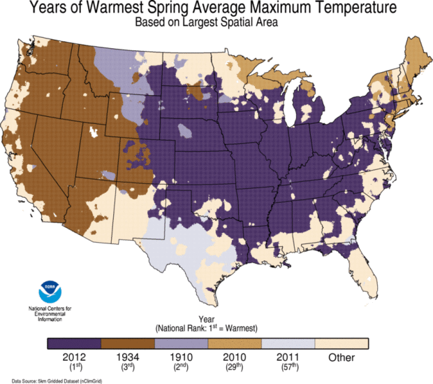 [Warmest Spring on record, since 1895, based on average daily maximum ("afternoon high") temperature, for each 5km-by-5km pixel in the contiguous United States. The five Springs with the largest footprint are depicted on this map. Please note that the five largest footprints are not necessarily the five warmest Springs, on average]
The major players are still the same: 2012, 1934 and 1910, in that order. The spring of 2010 still shows up around the Great Lakes and New England. But there’s a newcomer relative to the previous map.
In much of Texas and some of New Mexico, the spring of 2011 was the warmest on record. And that’s a bit unusual, because look at the national rank in parentheses: 57th warmest. So, Texas and some of New Mexico had their warmest spring on record while overall, averaged across the country, spring 2011 was in the middle of the pack, temperature-wise.
There are a few things to pull out. First, the spring of 2011 was a colossally extreme spring. We’ll detail that more in just a few paragraphs. But it’s relevant that Texas and New Mexico hit the mark for warm afternoons, rather than mornings. That’s related to how dry it was there at the time. 2011 was a severe drought year in the southern plains, and the dryness really became entrenched early in the year.
Dryness and afternoon warmth are related. First off, those ridges that bring warm air inhibit widespread organized cloudiness and precipitation. Also, when soils are dry, the Sun’s energy goes exclusively into raising the temperature, rather than being split between that and evaporating some water. This effect is more dramatic in the summer, but the sun is high enough in the sky during spring (especially down there around 30 degrees latitude) that this effect can really play out.
[Warmest Spring on record, since 1895, based on average daily maximum ("afternoon high") temperature, for each 5km-by-5km pixel in the contiguous United States. The five Springs with the largest footprint are depicted on this map. Please note that the five largest footprints are not necessarily the five warmest Springs, on average]
The major players are still the same: 2012, 1934 and 1910, in that order. The spring of 2010 still shows up around the Great Lakes and New England. But there’s a newcomer relative to the previous map.
In much of Texas and some of New Mexico, the spring of 2011 was the warmest on record. And that’s a bit unusual, because look at the national rank in parentheses: 57th warmest. So, Texas and some of New Mexico had their warmest spring on record while overall, averaged across the country, spring 2011 was in the middle of the pack, temperature-wise.
There are a few things to pull out. First, the spring of 2011 was a colossally extreme spring. We’ll detail that more in just a few paragraphs. But it’s relevant that Texas and New Mexico hit the mark for warm afternoons, rather than mornings. That’s related to how dry it was there at the time. 2011 was a severe drought year in the southern plains, and the dryness really became entrenched early in the year.
Dryness and afternoon warmth are related. First off, those ridges that bring warm air inhibit widespread organized cloudiness and precipitation. Also, when soils are dry, the Sun’s energy goes exclusively into raising the temperature, rather than being split between that and evaporating some water. This effect is more dramatic in the summer, but the sun is high enough in the sky during spring (especially down there around 30 degrees latitude) that this effect can really play out.
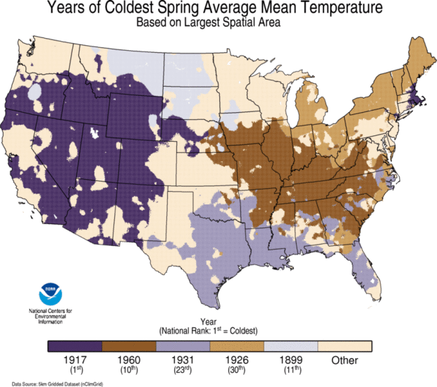 [Coldest Spring on record, since 1895, based on average temperature, for each 5km-by-5km pixel in the contiguous United States. The five Springs with the largest footprint are depicted on this map. Please note that the five largest footprints are not necessarily the five coldest Springs, on average.]
A quick look at the coldest springs on record indeed shows a slightly more fractured map than those for warm one. With that said, spring 1917 is pretty darn impressive on the cold side, dominating the western U.S., and picking up some spots in New England. It was the coldest spring on record for the country, and it’s not really that close.
Finally, let’s look at the driest and wettest springs on record.
[Coldest Spring on record, since 1895, based on average temperature, for each 5km-by-5km pixel in the contiguous United States. The five Springs with the largest footprint are depicted on this map. Please note that the five largest footprints are not necessarily the five coldest Springs, on average.]
A quick look at the coldest springs on record indeed shows a slightly more fractured map than those for warm one. With that said, spring 1917 is pretty darn impressive on the cold side, dominating the western U.S., and picking up some spots in New England. It was the coldest spring on record for the country, and it’s not really that close.
Finally, let’s look at the driest and wettest springs on record.
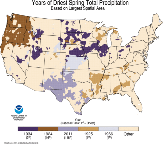 Precipitation maps are even more fractured, because precipitation generally has sharp gradients and sharp boundaries and painful detail. Using only five crayons leaves a lot of the map as “other.” But we still have some relevant information. Check out Texas and New Mexico. There’s 2011. Their warmest spring generally overlapped with their driest, for the reasons spelled out above.
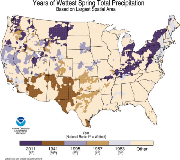 Now look at the Wet spring map. There’s 2011. Again. The Ohio Valley got all kinds of dumped on that season. There were epic floods throughout the season in the region. The spring of 2011 was marked by profound regional extremes.
Also, one last nugget. The spring of 1957 was the wettest spring on record, when averaged across the United States. That was a great drought buster in the South, and effectively put an end to more than a half-decade of some of the worst droughts, if not the worse, to hit the region. The point here is that the epic droughts often end with colossally wet seasons.
Edited for WeatherNation by Meteorologist Mace Michaels
Now look at the Wet spring map. There’s 2011. Again. The Ohio Valley got all kinds of dumped on that season. There were epic floods throughout the season in the region. The spring of 2011 was marked by profound regional extremes.
Also, one last nugget. The spring of 1957 was the wettest spring on record, when averaged across the United States. That was a great drought buster in the South, and effectively put an end to more than a half-decade of some of the worst droughts, if not the worse, to hit the region. The point here is that the epic droughts often end with colossally wet seasons.
Edited for WeatherNation by Meteorologist Mace Michaels
[Driest Spring on record, since 1895, based on precipitation, for each 5km-by-5km pixel in the contiguous United States. The five Springs with the largest footprint are depicted on this map. Please note that the five largest footprints are not necessarily the five driest Springs, on average.]
All Weather News
More
Fronts Continue To Spark Severe Weather Across the Plains
A cold front that brought record lows to the
18 Jul 2025 10:40 PM

Extreme Heat Impacts for the East Coast & South
Extreme heat continues to impact several area
18 Jul 2025 10:05 PM

Flooding Threat Remains Elevated in the East
A cold front pushing through the Eastern Seab
18 Jul 2025 9:10 PM

EF-2 Firenado from the Deer Creek Fire in Utah
A fire tornado was spotted near La Sal, Utah
18 Jul 2025 7:30 AM

Tropical System Brings Flood Risk to the Central Gulf
Time has run out for notable tropical develop
18 Jul 2025 3:05 AM

Heavy Rain, Flooding Threat Returns to Florida
Keep the rain boots handy in Florida - heavy
13 Jul 2025 12:50 PM

Severe Storm Risk Pushes into the Great Lakes, Ohio Valley
Friday was another busy day with severe weath
12 Jul 2025 8:00 PM