Tropics: Dolly Weakens To Remnant Low

Top Stories
24 Jun 2020 4:30 AM
The fourth named storm of the Atlantic hurricane season lasted for less than forty-eight hours, becoming a "post tropical remnant low" on Wednesday.
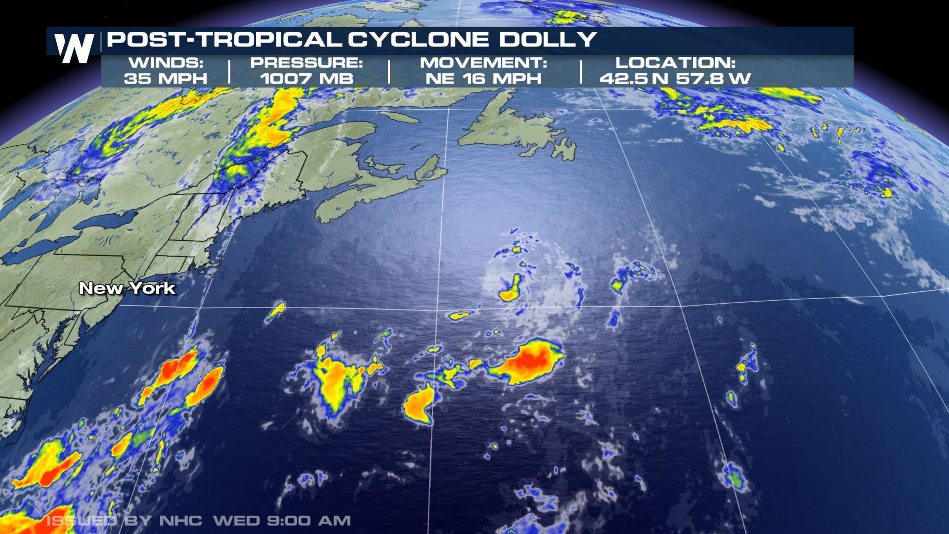 The statistics on Post-Tropical Cyclone Dolly as of 11 a.m. ET Wednesday. *Note* This is the final advisory issued by NHC for this system.
The technicality of this means that thunderstorms around the center of Dolly diminished, while the low pressure center moves over cooler sea surface temperatures in the northern Atlantic. While Dolly no longer exists, gale-force wind and larger waves/swells will still impact the northern Atlantic. You can read more about this in the North Atlantic High Seas Forecast by clicking or tapping here.
The statistics on Post-Tropical Cyclone Dolly as of 11 a.m. ET Wednesday. *Note* This is the final advisory issued by NHC for this system.
The technicality of this means that thunderstorms around the center of Dolly diminished, while the low pressure center moves over cooler sea surface temperatures in the northern Atlantic. While Dolly no longer exists, gale-force wind and larger waves/swells will still impact the northern Atlantic. You can read more about this in the North Atlantic High Seas Forecast by clicking or tapping here.
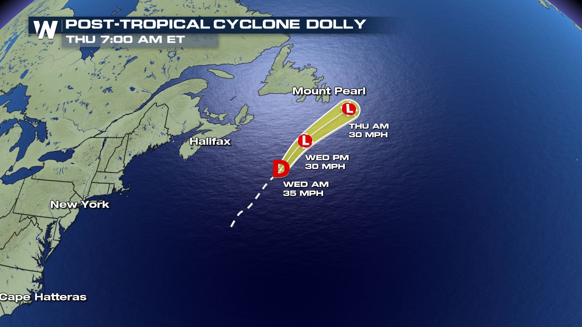 The forecast on Post-Tropical Cyclone Dolly as of 11 a.m. ET Wednesday. *Note* This is the final advisory issued by NHC for this system.
There were nine advisories issued for this storm, including a special advisory around noon Tuesday which stated Tropical Storm Dolly had formed. Prior to this, the system was referred to as Subtropical Depression Four beginning 5 p.m. Monday. The strongest estimated winds reached 45 miles per hour.
Related Article: NOAA Expects Above Average Hurricane Season
While short-lived, Dolly was the fourth named storm of the 2020 Atlantic basin season, and far earlier than usual. Typically, the fourth named storm of the season doesn't take place until August 23rd, according to the National Hurricane Center's (NHC) climatology chart.
No direct impacts to land are expected, although some choppier surf and rip currents could be an issue for parts of the New England and Canadian maritime coastlines.
Stay with WeatherNation for the latest on the tropics.
The forecast on Post-Tropical Cyclone Dolly as of 11 a.m. ET Wednesday. *Note* This is the final advisory issued by NHC for this system.
There were nine advisories issued for this storm, including a special advisory around noon Tuesday which stated Tropical Storm Dolly had formed. Prior to this, the system was referred to as Subtropical Depression Four beginning 5 p.m. Monday. The strongest estimated winds reached 45 miles per hour.
Related Article: NOAA Expects Above Average Hurricane Season
While short-lived, Dolly was the fourth named storm of the 2020 Atlantic basin season, and far earlier than usual. Typically, the fourth named storm of the season doesn't take place until August 23rd, according to the National Hurricane Center's (NHC) climatology chart.
No direct impacts to land are expected, although some choppier surf and rip currents could be an issue for parts of the New England and Canadian maritime coastlines.
Stay with WeatherNation for the latest on the tropics.
The statistics on Post-Tropical Cyclone Dolly as of 11 a.m. ET Wednesday. *Note* This is the final advisory issued by NHC for this system.
The technicality of this means that thunderstorms around the center of Dolly diminished, while the low pressure center moves over cooler sea surface temperatures in the northern Atlantic. While Dolly no longer exists, gale-force wind and larger waves/swells will still impact the northern Atlantic. You can read more about this in the North Atlantic High Seas Forecast by clicking or tapping here.
The forecast on Post-Tropical Cyclone Dolly as of 11 a.m. ET Wednesday. *Note* This is the final advisory issued by NHC for this system.
There were nine advisories issued for this storm, including a special advisory around noon Tuesday which stated Tropical Storm Dolly had formed. Prior to this, the system was referred to as Subtropical Depression Four beginning 5 p.m. Monday. The strongest estimated winds reached 45 miles per hour.
Related Article: NOAA Expects Above Average Hurricane Season
While short-lived, Dolly was the fourth named storm of the 2020 Atlantic basin season, and far earlier than usual. Typically, the fourth named storm of the season doesn't take place until August 23rd, according to the National Hurricane Center's (NHC) climatology chart.
No direct impacts to land are expected, although some choppier surf and rip currents could be an issue for parts of the New England and Canadian maritime coastlines.
Stay with WeatherNation for the latest on the tropics.All Weather News
More

East Gears Up for Stormy, Wet Weekend
A low pressure system crashing through the Mi
1 Aug 2026 9:15 PM


Flooding, Severe Storms Target the Midwest Again
After an active week of storms across the nor
1 Aug 2026 1:40 AM

After Reaching Category 5, Genevieve Weakens in the Pacific
PacificFausto is now a post-tropical cyclone.
31 Jul 2026 1:30 AM

Flooding Risk Increases as Heavy Rain Targets the Tri-State Area
Tuesday, heavy rainfall moved across the Nort
30 Jul 2026 12:25 AM

Severe Weather: Energy From the Midwest Now in the Southeast
UPPER MIDWEST - Through Monday, dangerous tor
29 Jul 2026 10:30 PM