The Blizzard of ‘96: In Retrospect 25 Years Later
Special Stories
7 Jan 2021 2:00 AM
[From NOAA written by Chris Stachelski] It was the marquee meteorological event of one of the more epic winters ever -- a storm that, if you experienced it, still stands out in your memory to this date. You might not remember just how much snow fell, but that there was a lot of it. That it stranded you in place for a time. And then you had to dig on out. And in some places, the storm laid the foundation for another significant weather event in the subsequent weeks. It was the Blizzard of ‘96. Even though many areas have been impacted by it have seen bigger snowfalls in years since (February 2003 from the President’s Day II Storm, the Blizzards of February 2010, the Boxing Day Storm of December 2010, the snowstorms of February 2015 or more recently in January 2016), this storm is widely viewed as the Big One in the modern history of East Coast snowstorms of the last 25 years. It digs up memories akin to those from the Cleveland Superbomb in January 1978, the Blizzard of ‘78 in New England and metro New York City, the Megapolitan Storm of February 1983 and the Superstorm of March 1993 - storms that people still can recall decades later to extreme detail in some cases.
Storm Overview
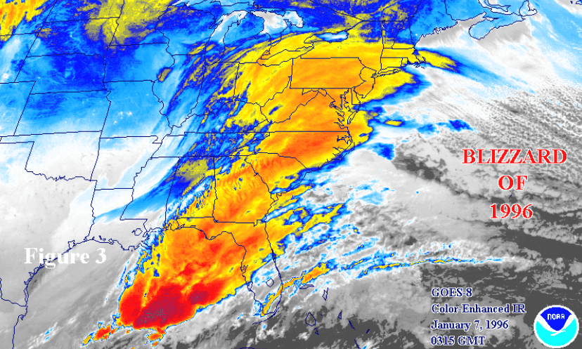
The storm formed in the Gulf of Mexico on the morning of January 6th. It reached the Georgia Coast by the morning of the 7th then moved northeast toward Cape Hatteras, NC by the evening of the 7th before reaching the waters off of Southern New England the evening of the 8th. The heavy snowfall was largely due to a combination of sufficient moisture aided by cold air pushed south from an Arctic high pressure located north of the storm that generated highly effective liquid precipitation to snow ratios and a highly favorable storm track. Significant and in many cases record breaking snow for either a 24 hour period or single snowstorm occurred with this event from the Ohio Valley to southwestern Virginia to the Washington, D.C. to southern New England urban corridor.
Why Was This Storm So Significant?
At the time it occurred, the Blizzard of ‘96 was said to be the greatest snowstorm in terms of the amount of snow that fell seen by so many people largely because it produced heavy and in many cases record-breaking snowfall in the highly populated Boston to Washington, D.C. corridor in addition to areas in southwest Virginia, eastern West Virginia, and the Ohio Valley. In 2004, the Northeast Snowfall Impact Scale (NESIS) that ranks Northeast snowstorms was developed. NESIS ranks the second most severe Northeast snowstorm on record behind the March 1993 Superstorm or “Storm of the Century” as it was commonly called then. However, the March 1993 was more of a significant snowstorm for the spine of the Appalachians with lesser amounts toward the more heavily populated urban corridor of the Northeast. It is exceedingly tough to have a snowstorm produce over a foot of snow from Washington, D.C. to Boston due the storm needing a favorable track. Often, snowstorms that are significant events in the Washington, D.C. area tend to be lesser events in southern New England such as in February 2010 or in the case of February 2015, significant in southern New England but not in the Washington, D.C. area.
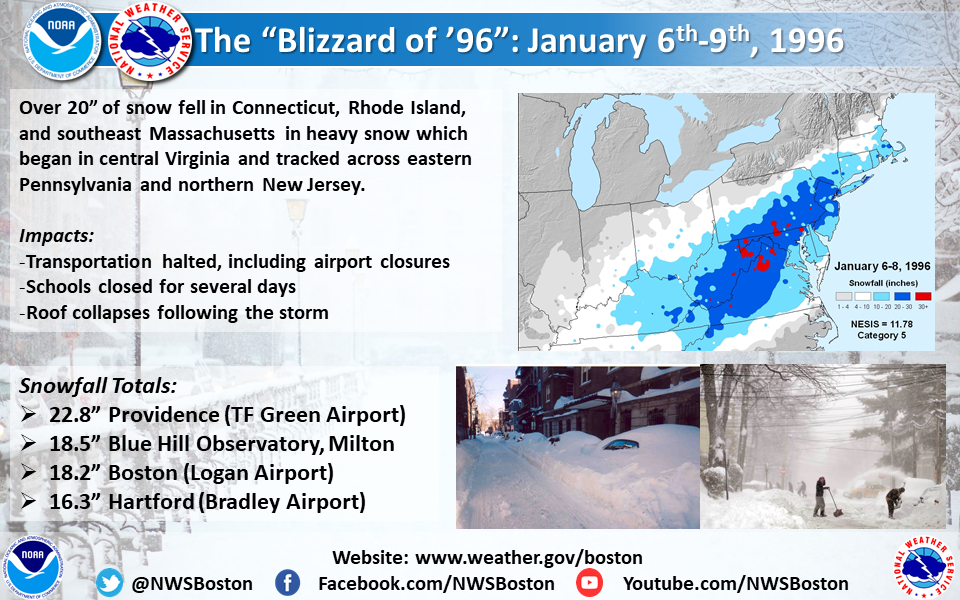
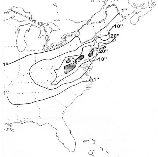 [Snowfall totals from the Blizzard of '96. Image from NOAA]
Was It Really A Blizzard?
For many, technically no. Officially, a blizzard means that the following conditions are expected to prevail for a period of 3 hours or longer - sustained wind or frequent gusts to 35 miles an hour or greater and considerable falling and/or blowing snow (i.e., reducing visibility frequently to less than ¼ mile). This event often failed to have the wind reach the criteria long enough in most areas. But, given the Blizzard Warnings issued for the event, the common usage of the name “Blizzard of ‘96” before, during, and after the event has stuck since, even in the meteorological community despite it not being technically correct in most locations. In today’s National Weather Service, issuing Blizzard Warnings based on the impact of the snow rather than the meteorology would be seen as an example of impact-based forecasting and warnings versus the old legacy strictly criteria based issuance as was often common in the 1990s.
What Was Forecasting and Data Collection Like Back Then?
Forecasting was much different in the mid-1990s versus today. The National Weather Service was in the middle of a nationwide modernization, moving offices to new facilities, closing some older, smaller offices and bringing into the operational world much of the newer generation of technology used today such as Doppler Radar and the Automated Surface Observing System or ASOS. However, graphical capabilities at offices were more limited with AFOS used as the primary system for composing products and reviewing meteorological data. Products were all hand typed. Model data was more limited in terms of models, parameters and visual display capabilities. The internet was in its infancy on a mainstream use using dial-up connectivity on a desktop computer, if available. Phone calls from storm spotters and the public and government officials, along with radio and television news, were the primary source of on-the-ground reports in real time, with hard copy newspapers used as follow up after the fact. Smartphones and social media were unknown. There were fewer reports, less visual evidence from the area, and a lot more interpolation of data, especially on overnight shifts.
Impacts of the Storm
Snow flurries even fell as far south from this system as Florida - stretching from Tallahassee to just north of Tampa in New Port Richey sending a touch of winter to a place many go to escape it. But the bigger snows the storm was noted for fell much further north, reaching as much as 48 inches in Snowshoe, West Virginia. In the most severely impacted areas, transportation was crippled for days, municipalities struggled to clear the snow and find places to put it, mail service was briefly halted from Atlantic City, NJ to Albany, NY, numerous roofs caved in from the weight of the snow damaging structures, schools and businesses closed for days, and newspaper delivery -- along with other supply delivery -- was halted. Many people were stuck at roadside rest stops. Along the coast, flooding occurred and the onshore flow resulted in the bizarre site at Atlantic City, NJ of hundreds of clam shells washing ashore into mounds on the beach. The snowpack in many areas reached over 2 feet and, with additional snows and cold following the storm, laid on the ground until a warm up later in January with a heavy rainfall that took place and resulted in major river flooding.
As always, the story of the Blizzard of ‘96 is best told by those who experienced it firsthand, either as an aspiring meteorologist or National Weather Service employee. The Blizzard of ‘96 had a profound impact on the lives of those in the meteorology community even beyond the forecast operations desk. As noted in the Service Assessment conducted by the National Weather Service following this event:
“The storm had a major impact on NWS employees and demonstrated the dedication and commitment of our workforce. Field and NCEP personnel worked around-the-clock with little relief. People brought extra food and sleeping bags to their respective offices and remained at these offices or in nearby hotels for 48 hours or longer. Sixteen-hour shifts and three hour commutes were common. People took extraordinary efforts to get to the office. In some cases, four wheel drive vehicles were used to ferry people to their offices while at least one employee cross-country skied to work. All this occurred during a Federal Government shutdown when most Federal employees were furloughed. Nonetheless, NWS employees continued to serve and ensure public safety around-the-clock without the assurance of paychecks. This conscientious ‘can do’ attitude of NWS employees likely contributed to the amazingly low death toll for an event of this magnitude.”
[Snowfall totals from the Blizzard of '96. Image from NOAA]
Was It Really A Blizzard?
For many, technically no. Officially, a blizzard means that the following conditions are expected to prevail for a period of 3 hours or longer - sustained wind or frequent gusts to 35 miles an hour or greater and considerable falling and/or blowing snow (i.e., reducing visibility frequently to less than ¼ mile). This event often failed to have the wind reach the criteria long enough in most areas. But, given the Blizzard Warnings issued for the event, the common usage of the name “Blizzard of ‘96” before, during, and after the event has stuck since, even in the meteorological community despite it not being technically correct in most locations. In today’s National Weather Service, issuing Blizzard Warnings based on the impact of the snow rather than the meteorology would be seen as an example of impact-based forecasting and warnings versus the old legacy strictly criteria based issuance as was often common in the 1990s.
What Was Forecasting and Data Collection Like Back Then?
Forecasting was much different in the mid-1990s versus today. The National Weather Service was in the middle of a nationwide modernization, moving offices to new facilities, closing some older, smaller offices and bringing into the operational world much of the newer generation of technology used today such as Doppler Radar and the Automated Surface Observing System or ASOS. However, graphical capabilities at offices were more limited with AFOS used as the primary system for composing products and reviewing meteorological data. Products were all hand typed. Model data was more limited in terms of models, parameters and visual display capabilities. The internet was in its infancy on a mainstream use using dial-up connectivity on a desktop computer, if available. Phone calls from storm spotters and the public and government officials, along with radio and television news, were the primary source of on-the-ground reports in real time, with hard copy newspapers used as follow up after the fact. Smartphones and social media were unknown. There were fewer reports, less visual evidence from the area, and a lot more interpolation of data, especially on overnight shifts.
Impacts of the Storm
Snow flurries even fell as far south from this system as Florida - stretching from Tallahassee to just north of Tampa in New Port Richey sending a touch of winter to a place many go to escape it. But the bigger snows the storm was noted for fell much further north, reaching as much as 48 inches in Snowshoe, West Virginia. In the most severely impacted areas, transportation was crippled for days, municipalities struggled to clear the snow and find places to put it, mail service was briefly halted from Atlantic City, NJ to Albany, NY, numerous roofs caved in from the weight of the snow damaging structures, schools and businesses closed for days, and newspaper delivery -- along with other supply delivery -- was halted. Many people were stuck at roadside rest stops. Along the coast, flooding occurred and the onshore flow resulted in the bizarre site at Atlantic City, NJ of hundreds of clam shells washing ashore into mounds on the beach. The snowpack in many areas reached over 2 feet and, with additional snows and cold following the storm, laid on the ground until a warm up later in January with a heavy rainfall that took place and resulted in major river flooding.
As always, the story of the Blizzard of ‘96 is best told by those who experienced it firsthand, either as an aspiring meteorologist or National Weather Service employee. The Blizzard of ‘96 had a profound impact on the lives of those in the meteorology community even beyond the forecast operations desk. As noted in the Service Assessment conducted by the National Weather Service following this event:
“The storm had a major impact on NWS employees and demonstrated the dedication and commitment of our workforce. Field and NCEP personnel worked around-the-clock with little relief. People brought extra food and sleeping bags to their respective offices and remained at these offices or in nearby hotels for 48 hours or longer. Sixteen-hour shifts and three hour commutes were common. People took extraordinary efforts to get to the office. In some cases, four wheel drive vehicles were used to ferry people to their offices while at least one employee cross-country skied to work. All this occurred during a Federal Government shutdown when most Federal employees were furloughed. Nonetheless, NWS employees continued to serve and ensure public safety around-the-clock without the assurance of paychecks. This conscientious ‘can do’ attitude of NWS employees likely contributed to the amazingly low death toll for an event of this magnitude.”
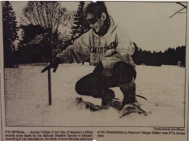 [Cooperative observer Bonnie Phillips measures snow at the Charlotteburg Reservoir, NJ cooperative site. Image from NOAA]
Below are the stories from a number of current and now retired National Weather Service employees who were inspired by or worked during this event and told from their personal perspective. We personally thank each of them for sharing their experiences of this event 25 years later as a way of preserving the significance of this event for years to come. It was a remarkable event for many meteorologists that either inspired their career in this profession, solidified it, or served as a benchmark moment in their career with the agency.
[Cooperative observer Bonnie Phillips measures snow at the Charlotteburg Reservoir, NJ cooperative site. Image from NOAA]
Below are the stories from a number of current and now retired National Weather Service employees who were inspired by or worked during this event and told from their personal perspective. We personally thank each of them for sharing their experiences of this event 25 years later as a way of preserving the significance of this event for years to come. It was a remarkable event for many meteorologists that either inspired their career in this profession, solidified it, or served as a benchmark moment in their career with the agency.
 [Image from NOAA]
 [Snowfall from the Blizzard of '96 in Baltimore, MD. From Robert Shawver via Wikimedia Commons CC 4.0]
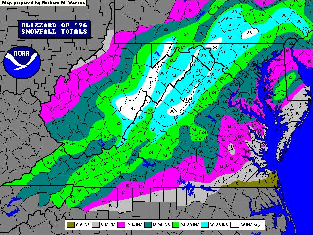
[Snowfall totals from the Blizzard of '96. Image from NOAA]
Was It Really A Blizzard?
For many, technically no. Officially, a blizzard means that the following conditions are expected to prevail for a period of 3 hours or longer - sustained wind or frequent gusts to 35 miles an hour or greater and considerable falling and/or blowing snow (i.e., reducing visibility frequently to less than ¼ mile). This event often failed to have the wind reach the criteria long enough in most areas. But, given the Blizzard Warnings issued for the event, the common usage of the name “Blizzard of ‘96” before, during, and after the event has stuck since, even in the meteorological community despite it not being technically correct in most locations. In today’s National Weather Service, issuing Blizzard Warnings based on the impact of the snow rather than the meteorology would be seen as an example of impact-based forecasting and warnings versus the old legacy strictly criteria based issuance as was often common in the 1990s.
What Was Forecasting and Data Collection Like Back Then?
Forecasting was much different in the mid-1990s versus today. The National Weather Service was in the middle of a nationwide modernization, moving offices to new facilities, closing some older, smaller offices and bringing into the operational world much of the newer generation of technology used today such as Doppler Radar and the Automated Surface Observing System or ASOS. However, graphical capabilities at offices were more limited with AFOS used as the primary system for composing products and reviewing meteorological data. Products were all hand typed. Model data was more limited in terms of models, parameters and visual display capabilities. The internet was in its infancy on a mainstream use using dial-up connectivity on a desktop computer, if available. Phone calls from storm spotters and the public and government officials, along with radio and television news, were the primary source of on-the-ground reports in real time, with hard copy newspapers used as follow up after the fact. Smartphones and social media were unknown. There were fewer reports, less visual evidence from the area, and a lot more interpolation of data, especially on overnight shifts.
Impacts of the Storm
Snow flurries even fell as far south from this system as Florida - stretching from Tallahassee to just north of Tampa in New Port Richey sending a touch of winter to a place many go to escape it. But the bigger snows the storm was noted for fell much further north, reaching as much as 48 inches in Snowshoe, West Virginia. In the most severely impacted areas, transportation was crippled for days, municipalities struggled to clear the snow and find places to put it, mail service was briefly halted from Atlantic City, NJ to Albany, NY, numerous roofs caved in from the weight of the snow damaging structures, schools and businesses closed for days, and newspaper delivery -- along with other supply delivery -- was halted. Many people were stuck at roadside rest stops. Along the coast, flooding occurred and the onshore flow resulted in the bizarre site at Atlantic City, NJ of hundreds of clam shells washing ashore into mounds on the beach. The snowpack in many areas reached over 2 feet and, with additional snows and cold following the storm, laid on the ground until a warm up later in January with a heavy rainfall that took place and resulted in major river flooding.
As always, the story of the Blizzard of ‘96 is best told by those who experienced it firsthand, either as an aspiring meteorologist or National Weather Service employee. The Blizzard of ‘96 had a profound impact on the lives of those in the meteorology community even beyond the forecast operations desk. As noted in the Service Assessment conducted by the National Weather Service following this event:
“The storm had a major impact on NWS employees and demonstrated the dedication and commitment of our workforce. Field and NCEP personnel worked around-the-clock with little relief. People brought extra food and sleeping bags to their respective offices and remained at these offices or in nearby hotels for 48 hours or longer. Sixteen-hour shifts and three hour commutes were common. People took extraordinary efforts to get to the office. In some cases, four wheel drive vehicles were used to ferry people to their offices while at least one employee cross-country skied to work. All this occurred during a Federal Government shutdown when most Federal employees were furloughed. Nonetheless, NWS employees continued to serve and ensure public safety around-the-clock without the assurance of paychecks. This conscientious ‘can do’ attitude of NWS employees likely contributed to the amazingly low death toll for an event of this magnitude.”
[Cooperative observer Bonnie Phillips measures snow at the Charlotteburg Reservoir, NJ cooperative site. Image from NOAA]
Below are the stories from a number of current and now retired National Weather Service employees who were inspired by or worked during this event and told from their personal perspective. We personally thank each of them for sharing their experiences of this event 25 years later as a way of preserving the significance of this event for years to come. It was a remarkable event for many meteorologists that either inspired their career in this profession, solidified it, or served as a benchmark moment in their career with the agency.
- "I was interested in weather well before this event going back to the 1980s due to everything from thunderstorms to flooding to Hurricane Gloria. I lived in northern New Jersey in a town named Wanaque on the western slope of a mountain by East Coast standards around 500 feet in elevation. We had a bunch of big snowstorms in recent years in the 90s - the Nor’Easter of December ‘92, the March 1993 Superstorm and the winter of 1993-1994 which at the time was considered the most severe winter in this area since the late 1970s. The winter of 1995-1996 was different. I recall standing outside of high school in early November one afternoon and seeing a burst of snow flurries - which was a little unusual for that early in the season. The accumulating snows that season started in late November and kept right on going into December. My last true White Christmas I ever experienced was in 1995. Then came January. We had snow going to this event already on the ground. I remember there being a forecast for snow in the days before, and then amounts went up. Saturday my parents and I came home from the store and put the television on to see what the forecast was. Totals had been increased and over a foot was being forecasted. Off to the grocery store they went. The next morning, it was extremely cold. Newark Airport tied a record low at the time that morning, January 7th, which was very unusual to see before a snowstorm in New Jersey. Forecasted snow amounts had increased further and Blizzard Warnings had been issued. We had yet to take down our Christmas decorations outside and went outside to remove them before they became encased in snow for a while. The snow ramped up the night of the 7th and continued into the 8th. By late in the afternoon on the 8th, the snow let up that we ventured into our garage and my parents and I stood in amazement at the snow as seen in the forthcoming photos. It was literally a wall. We were stranded. Shrubs were buried and the street was impassible and could barely be made out. All you saw was snow. My dad remarked “I only recall maybe once seeing this much snow before” which “was when I was a kid we had a lot of snow one year the day after Christmas”. My dad grew up in the Newark, NJ area and looking back at the records he was correct as the longtime snowstorm of record for metropolitan New York City was the storm of December 26-27, 1947. I was impressed that he could recall that nearly 48 years later, but realized that for a child to remember that sort of snow this many years later, it really put this storm as well as that one into perspective and that I witnessed a big snowstorm. It was still snowing into the evening of the 8th. The next day I trekked out with a ruler and attempted to measure how much snow fell. I looked at about a dozen different spots that looked the best and carefully lowered a yardstick down to not punch through all the snow and measured an average of 29.9 inches. The depth on the ground at that point was around 34 to 35 inches in the most representative spots with higher drifts. It was staggering and at that point, the deepest I ever saw. It was in many areas of northern New Jersey the deepest snowpack since February 1961 and a value not exceeded since. I never saw this much snow on the ground until I went to the West Coast years later in the Cascades and Sierra. And it was a good thing we took our Christmas decorations down when we did because many people had them up for weeks until the snow finally melted for good later in January - nearly a month after Santa left for the North Pole. We got more snow that winter and all the way through mid-April. Everyone was ready for summer that year and a number of people actually put their homes up for sale that spring in this area due to the severity of the winter and moved to warmer climates." --Chris Stachelski, NWS Eastern Region Headquarters
- "I had just started working in the State College forecast office in June 1993. This was after working in the Binghamton, NY office for 6.5 years. 1996 was very similar to the first winter here (1993-1994). I was down at the Farm Show in Harrisburg, PA the day before the 1996 blizzard. Upon coming back up over the mountain to State College. The next day I went to church, it was snowing hard and windy. I came to work after the storm ended. Roads were taken care of well. Back then we got a lot of calls with spotters calling in reports. Also I don't recall seeing many reports of wrecks on area roads. Temperatures were on the cold side, compared to storms of late years. I did not go back to the farm show that Sunday or Monday, but heard they allowed folks to spend the night there. In the last few years, we get less calls from folks. We still get some media calls. This year has seen a large increase in the reports of wrecks, even in good weather. This past storm we just had featured decent clearing of the roads." -- David Martin, NWS WFO State College, PA
- "I remember it very well. I was working at TDL in Silver Spring, MD at the time, but you may recall that just as this snow storm began we had come out of a two week long Government Shutdown. Then the D.C. area was shut down for 3-4 more days because of this winter storm. My home at the time was in Harpers Ferry, WV, but more properly on the Blue Ridge mountains in a little community right on the WV/VA line called Shannondale, about 10 miles southeast of the actual town of Harpers Ferry. Being that I worked at headquarters, I was off for the Christmas Holidays and made the fortunate decision given the prospect of the snow storm and the government shut down to stay with my parents who lived in McKinney, TX. I was originally scheduled to return to D.C. the day the historic snow storm began. I found out that it was so bad in my home neighborhood back in WV that they had to get the National Guard in there to plow the roads because the developer of the area where I lived had no functioning snow removal equipment. My house there in WV received 42 inches during the first storm with another 6 inches on Friday of that week, which brought 8 inches to D.C. I believe the government was only open on Thursday of that week. So, a total of 48 inches. I returned to my home in WV on Sunday. The roads had been cleared by then, but there were huge mountains of snow everywhere! At the end of the following week temperatures warmed into the 60s, there was steam rising off the piles of snow still remaining all over the area, and rain of 2.5 inches combined with the melting snow to push many rivers into flood including the Potomac and Shenandoah, which is turn shut down the train service from Martinsburg into D.C. (the MARC train which I usually rode to work each day during the 8 1/2 years I lived up there). Then, an Arctic cold front followed and the temperature by the same evening was in the teens and a lot of the water froze in place, in some places 2-4 inches I think between ruts of remnant snow. What a huge mess! This was one of many big snow storms I recall while I was living there. I was definitely there during the March 1993 blizzard and I was unable to get out of my house for three days! I received 24 inches of snow during that one, 20 inches of which fell in 8 hours. We were under a blizzard warning during that event, March 12-13, 1993. There were many more incidents of this nature, like 6 inches in one hour during a thunder snow storm on March 5, 1995. Fortunately, it is a lot easier to take "AL" when you work at headquarters than when you are in a WFO working operational shifts! Honestly, I could have written a large diary about my experiences traveling between my home in the WV Panhandle and Silver Spring, MD during my 8.5 years up there in the 90s! The 1995-1996 winter had big snow events all the way from October until April and some snow on the ground pretty much continuously during that period!" -- Robert Beasley, NWS WFO Blacksburg, VA
- "I lived through it in Central NJ and it served as the impetus for my interest in meteorology. My decision to pursue it as a career was solidified after Tropical Storm Floyd in 1999. I was only 7 years old at the time the Blizzard of ‘96 occurred but I remember the cars in my driveway were completely buried and I only saw two large hills in their normal spots. I was really confused wondering where the cars went. Everything looked different and I was in awe at how much my normal backyard and neighborhood completely changed because of the 22 inches of snow that fell. Also, our normal lives were placed on hold for the few days afterwards as we all dug ourselves out of the snow. I was fascinated that Mother Nature could be responsible for completely changing our daily routine and could place everyone's life on hold. Because of this storm, I wanted to learn more about how Mother Nature can be responsible for such drastic changes to our normal everyday lives. The Blizzard of 1996 is still well remembered by many people in NJ and across the Northeast even 25 years later. Not many storms (outside of hurricanes) trigger that sort of memory. Even when I was at Rutgers, my professors ranked the Blizzard of 1996 as one of the most historic snow events ever to impact the I-95 corridor and it was discussed when we learned about nor'easters. Many of my classmates also said it sparked their interest in meteorology as well." -- Christina Speciale, NWS WFO Albany, NY
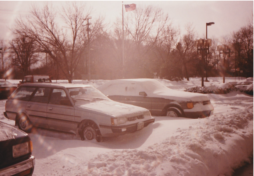
- "At the time of the 1996 blizzard I was early in my career (started September 1994), serving as an intern within the DTB of what was then HPC (now WPC). At that time we were in the World Weather Building (WWB) at Camp Springs, MD. My main functions included assisting the SDM with raob/aircraft QC, producing the Daily Weather Map, and entering products that our forecasters prepared into the computer system that would send them out. I'm originally from central Ohio and was in either Ohio or Indiana (two years at Purdue) my entire life before coming to the DC area in 1994, and before 1996 the heaviest snowfall I had experienced was a 10-12" event in late February 1984. I remember that the 1996 storm was in the middle of working night shifts, with the snow starting maybe around 9:30 P.M. Saturday night. There was a lull around midday/afternoon Sunday when precip became lighter and mixed in type. Then I think it was in the early-mid evening when the snow resumed and the wind strengthened. The snow finally tapered off by Monday morning or midday. The combination of my work schedule and duration of the storm ultimately led me to being onsite at the WWB from starting my Saturday night shift until departing from work early Tuesday morning. I was young and excited about experiencing by far the biggest snow event of my life up to that time, so I don't think I could have had a lot of sleep even if I had tried, and survived through that pretty well as I recall. Interestingly my memory was so focused on the event that I don't remember what activities if any I may have helped out with beyond my regular shift duties. One of the other memories from just after the event was how difficult of a time the DC area had in properly clearing the roads, as I recall various places where a lane would be plowed and at some point just cut out with a pile of snow. That's something I wasn't ready for from my lighter snowfall experiences in the Ohio Valley. Also I found a small number of pictures I still have from the event and they are attached. Two are from in front of the WWB after the storm ended, and another that I think was during the Sunday afternoon lull--happy that I had the foresight to park my car out in the open so that the snow would blow around it instead of drifting onto it." -- Marty Rausch, NOAA/NWS/Weather Prediction Center
[Image from NOAA]
- "This was the largest snow I had ever seen from one storm in my life...then Dec 16-17th, 2020 just happened and beat it by 10 inches. Awesome to see my kids to now have a memorable storm, like the one in ‘96 that I had told them about many times. When I woke up Thursday morning, I was also shocked to tell them that this was bigger than the ‘96 Blizzard for me. I lived in Northern Dutchess County, NY. My most memorable part of ‘96 was that the one side of my house where the drift formed was buried in snow right to the roof (9 feet high). I remember going on the roof and jumping into that drift and being buried...took me 5 minutes to get out from it. I was only 16 years old at the time and was already interested in Meteorology before this thanks to many other epic storms (Snow leaf 1987, Superstorm, the whole 1994 winter, and this storm)." -- Michael Patrick Kistner, NWS WFO Binghamton, NY
- "I was a Met Intern at NWS New York for this storm. Thankfully Brookhaven Labs still had its Army barracks for the staff to sleep at, as roads had about a foot of snow and visibility near zero. Lead Forecaster Bob Stalker and I barely made it to the barracks from the office, which is less than a mile away!Launching the weather balloon at the office during the storm was a top memory of it. Snowfall was so intense and visibility near zero along with strong northeast winds, meteorologist Tom Mazza and I had to walk backwards to the upper air shelter. We then had to launch the balloon from a nearby hill, given the strong northeast winds the balloon would not have cleared the tree line if we launched from the upper air building. Pretty cool, the first launch attempt was successful. We were so proud of ourselves given our rookie status as Met Interns. The ETA model did an excellent job simulating storm intensity, track and forecasted precipitation days in advance. It was a big win for the ETA!" -- Frank Nocera, NWS WFO Boston/Norton, MA
- "There are three things that I remember most from the Blizzard of '96. It's amazing how much weather forecasting has improved over the last quarter century. Even though there were some hints that something big might happen on Sunday the 7th, I don't think that we really began to mention the potential for snow in our forecast until Wednesday the 3rd. With the models not being as sophisticated as they are now, there was a tendency to be a bit more conservative with our forecasts at that time. While I was involved in the forecast process during the lead-up to the storm, I was actually scheduled off on Saturday the 6th and Sunday the 7th. I was supposed to return for a day shift on Monday the 8th but I was unable to get my car out of the parking lot of the apartment complex where I lived. It was too far to walk, about 6 miles. It was the only time in my 35 years with the National Weather Service that I was unable to make my way into work due to the weather. Before this year, it was the only other time that I can remember the supply chain failing. We were unable to get some necessities such as bread and milk for several days after the storm." -- Dean Iovino, NWS WFO Mount Holly, NJ
- "The 1996 storm is the favorite weather event of my NWS career (46 years). Snowstorms have always been at the top of my favorite weather event list. 3 storms are etched in my memory. All of them because I ended up in the office for much longer than a regular shift. In the 1979 storm I was in the office for 24 hours straight. In the 1983 storm it was 25 hours. For both of those storms, our office was located on Arch Street in Philadelphia. But my favorite snowstorm of all time was the January 1996 one. Whenever I did one of my school presentations (I was the Education Outreach Program Director for many years), I always spoke about the 1996 snowstorm when winter weather was involved. Our office moved to its present location in Mt. Holly, NJ in 1993. Since I lived (and currently still reside) in Lindenwold, Camden County, it took me about 30 minutes to drive to the office. On the morning of Sunday January 7, 1996, I was scheduled to be in the office for the beginning of my shift at 7 A.M. But with the computer models showing a start time of 4 to 5 A.M., I decided that I would get in a little early. I arrived at the office at 5 A.M., just as the first flakes began to fall. If I recall correctly, temperatures at that time were around 30 degrees. To make a long story a little shorter, the storm intensified rapidly as it moved up the coast. We had heavy snow throughout the day Sunday and into Sunday night. Temperatures dropped through the 20s and down to 15 degrees at the height of the storm. Winds gusted to around 40 mph at the office dropping the visibility to near zero at times and blew the snow into drifts 5 to 7 feet high. The snow mixed with sleet at times Sunday night as warm air aloft moved in but surface temperatures remained in the upper teens. As the storm began to move away Monday morning, wrap around snow gave the region another few inches. The storm dropped 30.7 inches at Philadelphia International Airport. Most of our forecast area received 2 to 3 feet of snow. I ended up working 35 hours straight. Something I will never forget. The Governor declared a State of Emergency on Monday. So when I left to go home at 4 P.M., I was the only car on the roads. It was one of the most beautiful sights I have ever seen. Snow piled high everywhere. It felt really weird driving on I-295 and being the only car. Well, not the only car --- I first saw headlights and then a car in my rearview mirror. That turned out to be a State Trooper who pulled me over to ask why I was driving. After I explained, we enjoyed a few pleasantries and he sent me on my way. Of course, when I got home, my children were feverishly shoveling my driveway. They had about a third of it done. Just enough for me to pull the car off the street. It was a storm that I will never forget." -- Bob Wanton, retired general forecaster, NWS WFO Mount Holly, NJ
[Snowfall from the Blizzard of '96 in Baltimore, MD. From Robert Shawver via Wikimedia Commons CC 4.0]
- "Waxing Poetic About The Blizzard Of ’96: I had the fortunate(?) opportunity to work forecast shifts (including the start of it that Sunday morning) leading up to the blizzard and also a story for the day after on January 8th. From a climate and forecast perspective the city of Philadelphia had only one double digit snow storm between the February 1983 storm and this blizzard: The Storm Of The Century in March of 1993. A storm of this magnitude was not a common occurrence and if anything, they fizzled or became rainier closer to occurrence time. During the Storm Of The Century, I was working at the WFO in New York City and recalled all the models had that pegged 4 to 5 days in advance with very little variation in strength or track, a forecasting marvel for that time. I went in 12 hours early for my midnight shift because I was not going to make it if I waited until that evening. Fast forward to this blizzard and the modeling consensus was not there. I’d say this storm put the ECMWF model on the map as the “go to” model. In the late 90s there was the “EE” rule: if the ECMWF and ETA had it, run with it and leave the GFS & NGM behind. Back then the ECMWF ran only once a day (00z run on midnight shifts) and very little information about it made it into AFOS. I do not recall exactly, but when it did arrive, it probably was close to the time that products had to be issued. We hand typed all products back then. This was a forecast case of where the ECMWF had more of a northwest track than the other models. Meanwhile the GFS Model (labeled the MRF I think for the medium range part) was much farther southeast. A dance that has been repeated numerous times ever since: the closer we came to the event, the more northwest the GFS trended with the low. What looked like a Delmarva crush job, became a Delmarva/SE New Jersey crush job and eventually that morning of the blizzard an I-95 crush job. It is hard to put in perspective how lead time watches and warnings with this event differed from other lesser events: PHL had some 6-10” events in the city, so it is not as if it never snowed between 1983 and 1996, but not on the magnitude of this event outside of March 1993. I issued a winter storm watch the early morning of January 6th. Meteorologist Art Kraus who worked the day shift that Saturday issued winter storm warnings and I upgraded most of those warnings to Blizzard Warnings on Sunday morning January 7th . Pretty much as the snow was starting. My sense was if there was better modeling agreement, these watches and warnings would have been issued earlier. Poor Meteorologist-In-Charge Chet Henricksen had only one operational shift that month and it so happened to be that Sunday morning. He was covering I think for Art Kraus who wanted to go to the PA Farm Show. I don’t know how he made it home to Chester County Pennsylvania that afternoon. All the other meteorologists were stuck at the office. Which brings us to Monday January 8th. I was called about Noon that day and was asked to please come into the office (It is about a 15-minute drive from our house to the office) because everyone was there for over 24 hours and they were exhausted. I said sure. I had a Chevy Blazer. After The Storm Of The Century In March 1993, I had no problem driving that Blazer through 2 feet of snow to get to our home in Yorktown Heights, NY. The drive in would be a piece of cake. Little did I know about the wonders of NJ jughandles, until then. Instead of making an illegal left hand turn onto County Route 541, I decided to go the goody two shoes route and make the right hand turn into the jughandle and then make a left turn onto CR 541 at the end of it. Well that jughandle is huge and because of its eastern exposure that was very helpful in having the snow drifts get higher and higher the deeper I went into the jughandle. Yes, it happened, the snow became so deep.I became stuck. The Blazer literally was sitting on top of the snow drift and the wheels were not even in contact with the ground. Thankfully this was New Jersey and not Montana in this instance. There was a gas station that was open (no cell phones back then) and I called the office to tell them my predicament. Here my memory gets foggy (must have been the freezing cold). I do not remember if someone from the office drove over to pick me up or the tow truck operator pulled me out of the snowbank and I drove to work. I was fortunate I almost made it to the end of the jughandle. Either way I made it in that afternoon. I arrived at the office. I recall one of the greatest acts of unsolicited kindness ever done for me by a fellow employee. Matt Lorentson (then an intern) made a cup of hot tea for me and found a blanket to put on my shoulders to help me stop shivering. I will never forget this and he is symbolic of the people who work for the National Weather Service. We are one big family who help each other in times of need. I was glad I did get there, because my co-workers who were stuck sounded pretty incoherent. Going about 36 hours without any sleep will do that to you."-- Tony Gigi, retired Lead Forecaster, NWS WFO Mount Holly, NJ
- "I was living in Glen Cove, on the North Shore of Long Island in Nassau County. I remember the times leading up to the storm like the back of my hand. I was a senior at Saint Mary’s High School, in my last semester prior to graduating and moving on to SUNY Stony Brook. A nor’easter fanatic from a young age, with what little we had back in the mid 90s to track weather, I was keen on watching every newscast I could find. At first it was only an outside chance of impact for the New York City metro area, most guidance showing a glancing impact or slider to the south and east. As time got closer, it appeared more likely we would receive warning level snow and my excitement grew large. There was something about it, it felt like a bigger event was unfolding. Prior to leaving for a friends’ birthday party, forecasters increased the snow amounts to 8 to 14 inches and my excitement shot through the roof, carrying me through the night during the party. After arriving home, the forecast increased to 15 to 20 inches on January 5th, all the way to 20 to 30 inches after the onset. The snow fell, the winds blew, and conditions deteriorated rapidly. Snow fell at two inches per hour for many hours, the snow piled up, and the winds blew drifts to 6 feet. We dry slotted for a period which allowed me to join a few friends on a drive to the South Shore. We witnessed huge battering waves, beach erosion, coastal flooding, and winds easily gusting 50 to 60 mph. For a 17 year old kid fascinated with weather, it was epic. We ended up with 21 inches in Glen Cove though it was difficult to find the right spot to measure due to the drifts. Snow ended more than 24 hours after it began, the weather remained cold for a couple days then a warm up ensued. I ended up working for WFO OKX during my tenure at SUNY Stony Brook then went on to a now 20+ year career with the National Weather Service, spanning 7 positions in 4 states. It’s been a great journey. Hurricane Gloria sparked my weather interest in 1985, the Nor’easter of 92 kept the journey going, and the Blizzard of ‘96 was the icing on the cake, propelling me to become a Meteorologist for life." -- Ken Widelski, NOAA Liaison to FEMA, National IMAT White
All Weather News
More
Fronts Continue To Spark Severe Weather Across the Plains
A cold front that brought record lows to the
18 Jul 2025 10:40 PM

Extreme Heat Impacts for the East Coast & South
Extreme heat continues to impact several area
18 Jul 2025 10:05 PM

Flooding Threat Remains Elevated in the East
A cold front pushing through the Eastern Seab
18 Jul 2025 9:10 PM

EF-2 Firenado from the Deer Creek Fire in Utah
A fire tornado was spotted near La Sal, Utah
18 Jul 2025 7:30 AM

Tropical System Brings Flood Risk to the Central Gulf
Time has run out for notable tropical develop
18 Jul 2025 3:05 AM

Heavy Rain, Flooding Threat Returns to Florida
Keep the rain boots handy in Florida - heavy
13 Jul 2025 12:50 PM

Severe Storm Risk Pushes into the Great Lakes, Ohio Valley
Friday was another busy day with severe weath
12 Jul 2025 8:00 PM