The Polar Vortex and February's Extreme Cold
Special Stories
11 Mar 2021 1:00 AM
[From NOAA Climate written by Rebecca Lindsey] In late February, as the Southern Plains and Gulf Coast suffered through an unusually strong blast of wintry weather, weather talk turned to the polar vortex and the possibility that the extreme cold was yet another example of weather-gone-wild due to global warming. In this article, we’re talking to NOAA experts about the devastating extreme cold event and the polar vortex.
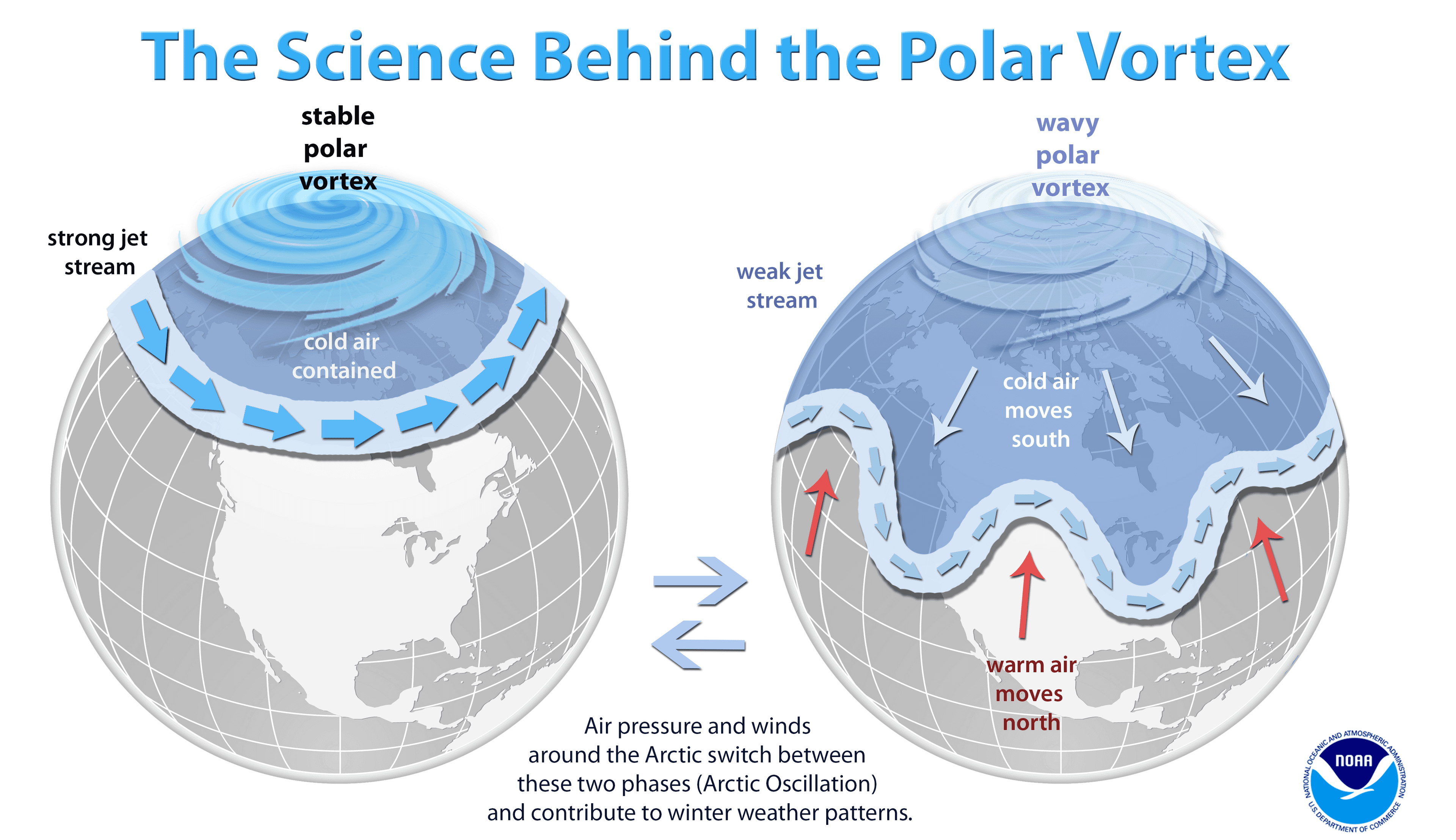
 [When the Arctic polar vortex is especially strong and stable (left globe), it encourages the polar jet stream, down in the troposphere, to shift northward. The coldest polar air stays in the Arctic. When the vortex weakens, shifts, or splits (right globe), the polar jet stream often becomes extremely wavy, allowing warm air to flood into the Arctic and polar air to sink down into the mid-latitudes. NOAA Climate graphic, adapted from original by NOAA]
According to NOAA stratosphere expert Amy Butler, people often confuse the polar vortex with the polar jet stream, but the two are in completely separate layers of the atmosphere. The polar jet stream occurs in the troposphere, at altitudes between 5-9 miles above the surface. It marks the boundary between surface air masses, separating warmer, mid-latitude air and colder, polar air. It’s the polar jet stream that plays such a big role in our day-to-day winter weather in the mid-latitudes, not the polar vortex.
[When the Arctic polar vortex is especially strong and stable (left globe), it encourages the polar jet stream, down in the troposphere, to shift northward. The coldest polar air stays in the Arctic. When the vortex weakens, shifts, or splits (right globe), the polar jet stream often becomes extremely wavy, allowing warm air to flood into the Arctic and polar air to sink down into the mid-latitudes. NOAA Climate graphic, adapted from original by NOAA]
According to NOAA stratosphere expert Amy Butler, people often confuse the polar vortex with the polar jet stream, but the two are in completely separate layers of the atmosphere. The polar jet stream occurs in the troposphere, at altitudes between 5-9 miles above the surface. It marks the boundary between surface air masses, separating warmer, mid-latitude air and colder, polar air. It’s the polar jet stream that plays such a big role in our day-to-day winter weather in the mid-latitudes, not the polar vortex.
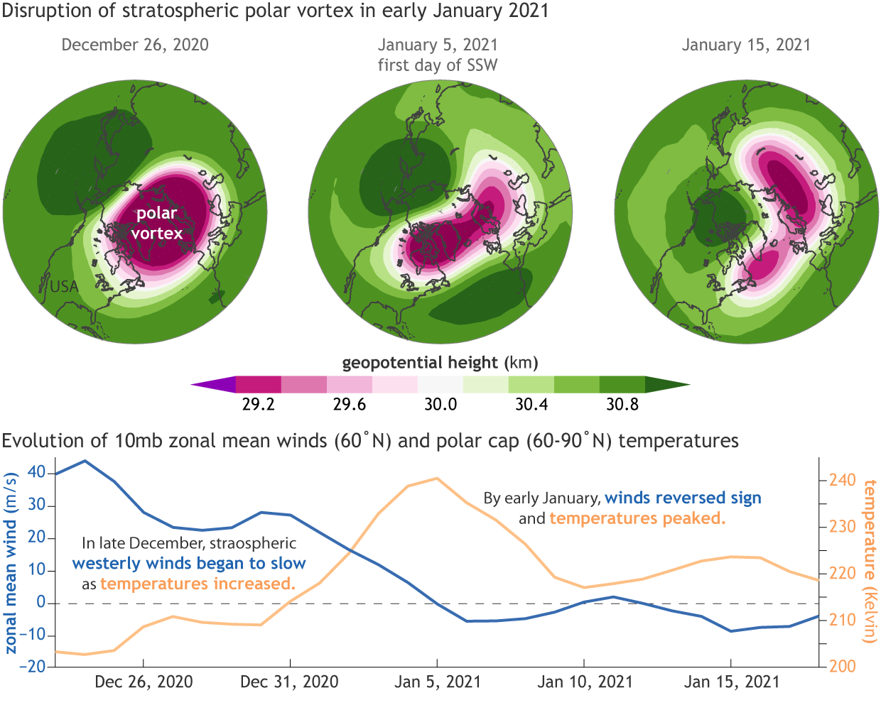 [The disruption of the Arctic polar vortex in January 2021. Globes show show 10-millibar geopotential heights—an indicator of air pressure—for (left) December 26, 2020 as the polar vortex began to weaken, (middle) on January 5, 2021 when the stratospheric winds reversed sign, and (right) on January 15, 2021 during the sudden stratospheric warming event. Images by Laura Ciasto, NOAA CPC.]
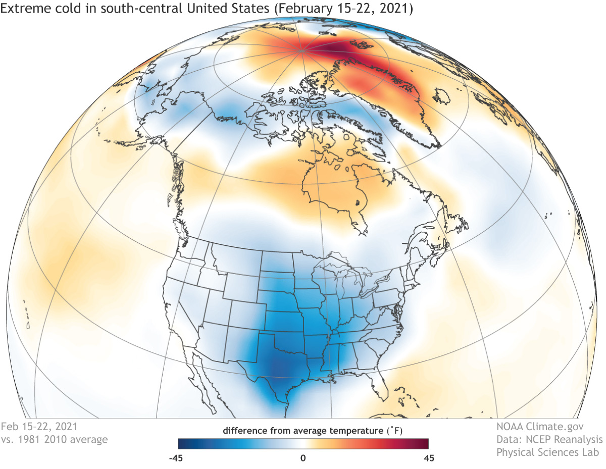 [Near-surface air temperatures across the Northern Hemisphere from February 15–22, 2021, compared to the 1981-2010 average. The polar jet stream made a deep dive into the south-central United States, bringing extreme cold (dark blue) to the Southern Plains. Meanwhile, parts of the Arctic were much warmer than average (orange and red). NOAA Climate image, based on NCEP/NCAR Reanalysis data from NOAA Physical Sciences Lab's daily composites tool.]
On the other hand, she said, plenty of Arctic cold air outbreaks happen in a given winter without any help from the polar vortex. Not to mention, sometimes the polar vortex is disrupted and there are few, if any, impacts on the weather down at the surface. So blaming the event solely on the polar vortex would be a stretch. (For a perspective on the possible role played Pacific ocean temperature patterns in a similar event that occurred in winter of 2013/14 and might be at play during this event, check out Dennis Hartmann’s ENSO blog post and his updated comments.)
Edited for WeatherNation by Mace Michaels
[Near-surface air temperatures across the Northern Hemisphere from February 15–22, 2021, compared to the 1981-2010 average. The polar jet stream made a deep dive into the south-central United States, bringing extreme cold (dark blue) to the Southern Plains. Meanwhile, parts of the Arctic were much warmer than average (orange and red). NOAA Climate image, based on NCEP/NCAR Reanalysis data from NOAA Physical Sciences Lab's daily composites tool.]
On the other hand, she said, plenty of Arctic cold air outbreaks happen in a given winter without any help from the polar vortex. Not to mention, sometimes the polar vortex is disrupted and there are few, if any, impacts on the weather down at the surface. So blaming the event solely on the polar vortex would be a stretch. (For a perspective on the possible role played Pacific ocean temperature patterns in a similar event that occurred in winter of 2013/14 and might be at play during this event, check out Dennis Hartmann’s ENSO blog post and his updated comments.)
Edited for WeatherNation by Mace Michaels
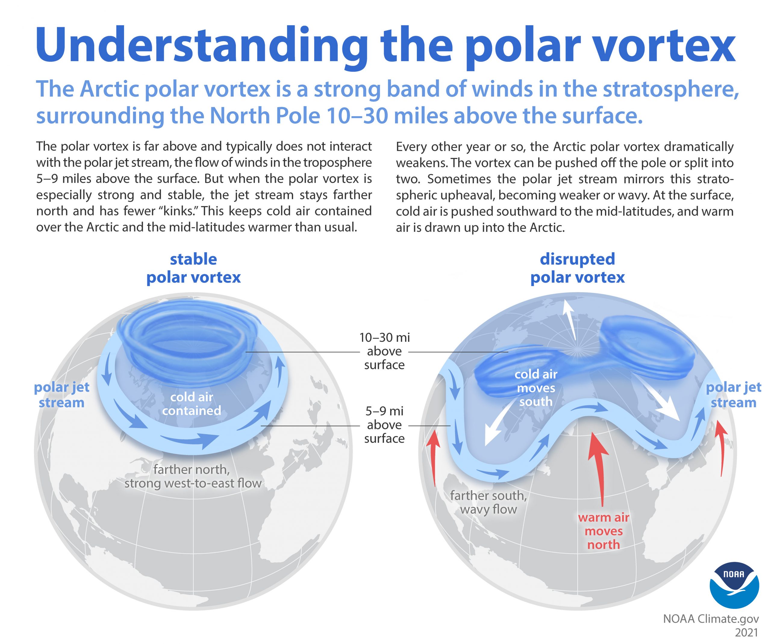
Polar vortex versus polar jet stream
The Arctic polar vortex is a band of strong westerly winds that forms in the stratosphere between about 10 and 30 miles above the North Pole every winter. The winds enclose a large pool of extremely cold air. (There is an even stronger polar vortex in the Southern Hemisphere stratosphere in its winter.) The stronger the winds, the more the air inside is isolated from warmer latitudes, and the colder it gets.
[When the Arctic polar vortex is especially strong and stable (left globe), it encourages the polar jet stream, down in the troposphere, to shift northward. The coldest polar air stays in the Arctic. When the vortex weakens, shifts, or splits (right globe), the polar jet stream often becomes extremely wavy, allowing warm air to flood into the Arctic and polar air to sink down into the mid-latitudes. NOAA Climate graphic, adapted from original by NOAA]
According to NOAA stratosphere expert Amy Butler, people often confuse the polar vortex with the polar jet stream, but the two are in completely separate layers of the atmosphere. The polar jet stream occurs in the troposphere, at altitudes between 5-9 miles above the surface. It marks the boundary between surface air masses, separating warmer, mid-latitude air and colder, polar air. It’s the polar jet stream that plays such a big role in our day-to-day winter weather in the mid-latitudes, not the polar vortex.
The polar vortex and our winter weather
The polar vortex doesn’t always influence winter weather in the mid-latitudes. When it does, however, the effects can be extreme. When the polar vortex is especially strong, for example, the polar jet steam tends to stay farther north and to exhibit a more zonal flow, with less meandering. At the surface, this stable stratospheric state is often associated with an even colder than usual Arctic, and milder-than-usual weather in the mid-latitudes. The Arctic Oscillation, which tracks hemisphere-scale wind and air pressure patterns, is often positive. https://www.youtube.com/watch?v=MEegw1OGFYY [Temperature (purple is cooler, pink is warmer) and winds (white lines) at the 250-millibar pressure level (the altitude at which the pressure is 250 millibars), showing the deeply wavy path of the polar jet stream across the United States on February 15, 2021. Screen capture from Earth.Nullschool, based on NOAA Global Forecast System data.] In the weeks following the stratospheric upheaval, the polar jet stream will often develop a wavy shape, with deep troughs and steep ridges that can become nearly stationary for days. The exact nature of the interaction—how the polar jet “feels” the disruption in the polar vortex and why it reacts the way it does—isn’t fully understood. Under the high-pressure ridges, warm air floods north into parts of the Arctic, often driving extreme melt, while polar air fills the low-pressure troughs, bringing wintry conditions farther south than average. The Arctic Oscillation often slips into its negative phase. At the other extreme, the polar vortex is occasionally knocked off kilter when especially strong atmospheric waves in the troposphere break upward into the stratosphere. The vortex slows, and it may wobble, slide off the pole, split into several lobes, or—in the most extreme cases—temporarily reverse direction. Regardless of their “flavor,” these disruptions have one thing in common: a spike in polar stratosphere temperatures, which is why they’re called sudden stratospheric warmings.
[The disruption of the Arctic polar vortex in January 2021. Globes show show 10-millibar geopotential heights—an indicator of air pressure—for (left) December 26, 2020 as the polar vortex began to weaken, (middle) on January 5, 2021 when the stratospheric winds reversed sign, and (right) on January 15, 2021 during the sudden stratospheric warming event. Images by Laura Ciasto, NOAA CPC.]
The polar vortex and the February 2021 cold extreme in the south-central United States
According to Butler, it’s reasonable to suppose that the polar vortex played a role in the extreme winter weather outbreak that struck the Southern Plains in late February. There is plenty of research linking disruptions of the stratospheric polar vortex to extreme cold air outbreaks in the mid-latitudes of the United States or Eurasia a few weeks later. “We did have a sudden stratospheric warming in January,” explained Butler. “The polar vortex weakened. It got stretched out of shape and slid southward off the pole. Most of the time when this happens—and it happens on average about every other year in the Arctic—some part of the mid-latitudes will ultimately experience a cold air outbreak. The disruption of the vortex encouraged the polar jet stream to become wavier for several weeks, and in combination with other weather patterns, created favorable conditions for a severe cold air outbreak in the central U.S.”
[Near-surface air temperatures across the Northern Hemisphere from February 15–22, 2021, compared to the 1981-2010 average. The polar jet stream made a deep dive into the south-central United States, bringing extreme cold (dark blue) to the Southern Plains. Meanwhile, parts of the Arctic were much warmer than average (orange and red). NOAA Climate image, based on NCEP/NCAR Reanalysis data from NOAA Physical Sciences Lab's daily composites tool.]
On the other hand, she said, plenty of Arctic cold air outbreaks happen in a given winter without any help from the polar vortex. Not to mention, sometimes the polar vortex is disrupted and there are few, if any, impacts on the weather down at the surface. So blaming the event solely on the polar vortex would be a stretch. (For a perspective on the possible role played Pacific ocean temperature patterns in a similar event that occurred in winter of 2013/14 and might be at play during this event, check out Dennis Hartmann’s ENSO blog post and his updated comments.)
Edited for WeatherNation by Mace MichaelsAll Weather News
More
Fronts Continue To Spark Severe Weather Across the Plains
A cold front that brought record lows to the
18 Jul 2025 10:40 PM

Extreme Heat Impacts for the East Coast & South
Extreme heat continues to impact several area
18 Jul 2025 10:05 PM

Flooding Threat Remains Elevated in the East
A cold front pushing through the Eastern Seab
18 Jul 2025 9:10 PM

EF-2 Firenado from the Deer Creek Fire in Utah
A fire tornado was spotted near La Sal, Utah
18 Jul 2025 7:30 AM

Tropical System Brings Flood Risk to the Central Gulf
Time has run out for notable tropical develop
18 Jul 2025 3:05 AM

Heavy Rain, Flooding Threat Returns to Florida
Keep the rain boots handy in Florida - heavy
13 Jul 2025 12:50 PM

Severe Storm Risk Pushes into the Great Lakes, Ohio Valley
Friday was another busy day with severe weath
12 Jul 2025 8:00 PM