Tides - One of the Most Reliable Occurrences on the Planet

Special Stories
5 Jul 2018 8:44 AM
[Image from pexels.com via NOAA]
Tides are one of the most reliable phenomena in the world. As the sun rises in the east and the stars come out at night, we are confident that the ocean waters will regularly rise and fall along our shores.
A lunar day is how long it takes for one point on the Earth to make one complete rotation and end up at the same point in relation to the moon. The reason that a lunar day is longer than a normal 24-hour day is because the moon rotates around the Earth in the same direction that the Earth is spinning. It takes the Earth an extra 50 minutes to “catch up” to the moon.
Tides are very long waves that move across the oceans. They are caused by the gravitational forces exerted on the earth by the moon, and to a lesser extent, the sun. When the highest point in the wave, or the crest, reaches a coast, the coast experiences a high tide. When the lowest point, or the trough, reaches a coast, the coast experiences a low tide.
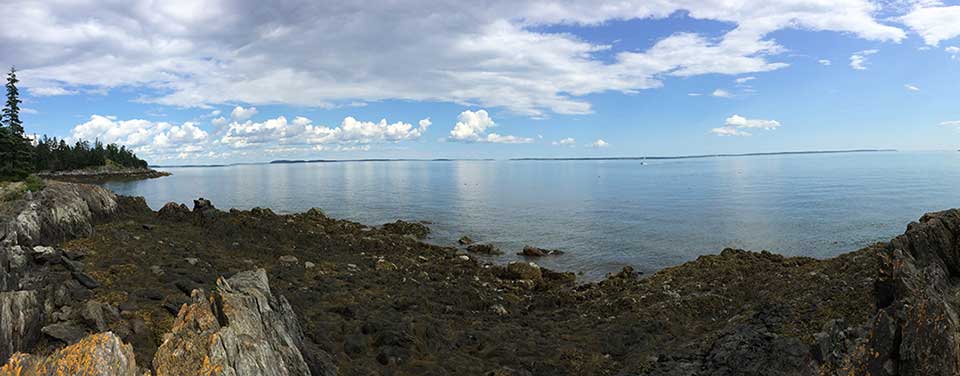 [Lowtide in Islesboro, Maine. From NOAA]
Imagine the ocean is shaped like a football pointing at the moon. The football’s pointed ends represent the parts of the Earth experiencing high tide and the football’s flat sides are the parts of the earth experiencing low tide. The point facing the moon is formed because the gravitational pull of the moon is strongest on whichever side of the Earth faces it. Gravity pulls the ocean towards the moon and high tide occurs.
The bulge on the far side of the Earth is caused by inertia. The water moving away from the moon resists the gravitational forces that attempt to pull it in the opposite direction. Because the gravitational pull of the moon is weaker on the far side of the Earth, inertia wins, the ocean bulges out and high tide occurs. As the Earth spins, different areas of the planet face the moon, and this rotation causes the tides to cycle around the planet.
[Lowtide in Islesboro, Maine. From NOAA]
Imagine the ocean is shaped like a football pointing at the moon. The football’s pointed ends represent the parts of the Earth experiencing high tide and the football’s flat sides are the parts of the earth experiencing low tide. The point facing the moon is formed because the gravitational pull of the moon is strongest on whichever side of the Earth faces it. Gravity pulls the ocean towards the moon and high tide occurs.
The bulge on the far side of the Earth is caused by inertia. The water moving away from the moon resists the gravitational forces that attempt to pull it in the opposite direction. Because the gravitational pull of the moon is weaker on the far side of the Earth, inertia wins, the ocean bulges out and high tide occurs. As the Earth spins, different areas of the planet face the moon, and this rotation causes the tides to cycle around the planet.
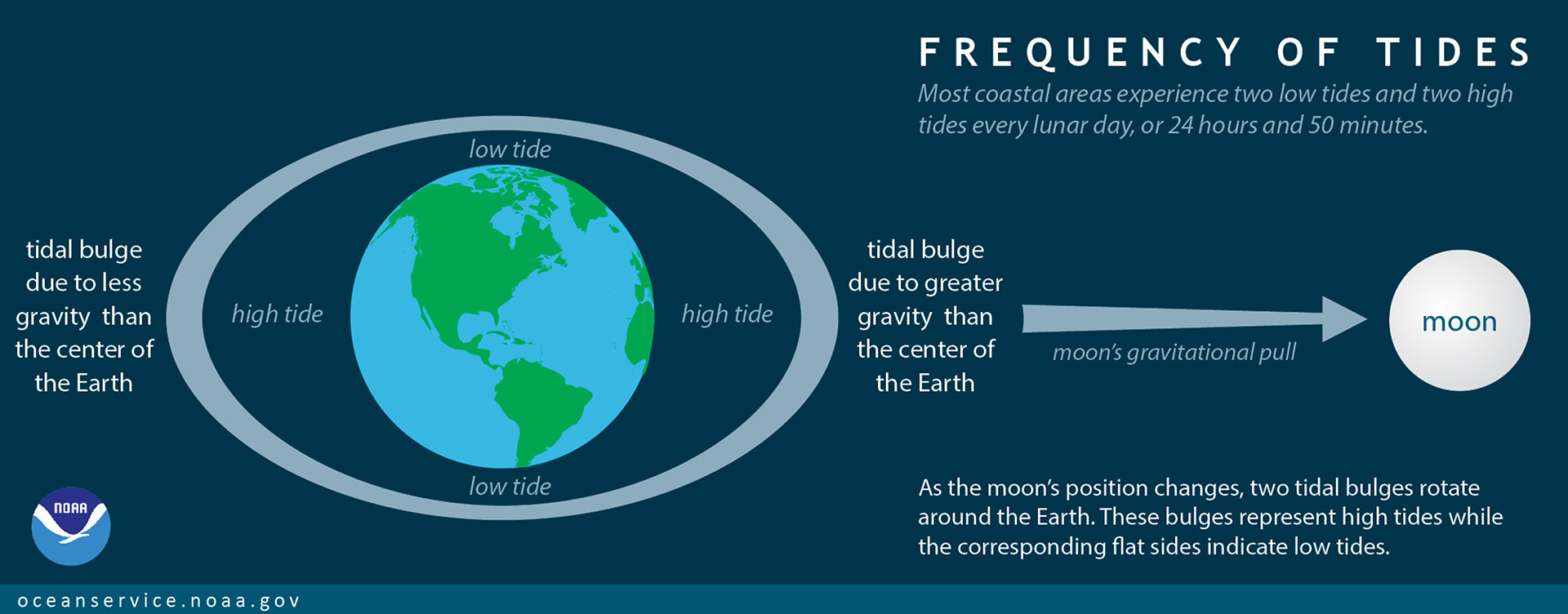 [The two tidal bulges caused by inertia and gravity will rotate around the Earth as the moons position changes. These bulges represent high tides while the flat sides indicate low tides. From NOAA]
While some places have one high tide and one low tide per day, most coastal locations have two high tides and two low tides a day. These highs and lows typically aren't equal. This is why, in most places, using the phrase "high tide" might be unclear. There's actually high tide and higher high tide (and low and lower low tide).
If the Earth were a perfect sphere without large continents, and if the earth-moon-sun system were in perfect alignment, every place would get two equal high and low tides every day. However, the alignment of the moon and sun relative the earth, the presence of the continents, regional geography and features on the seafloor, among other factors, make tidal patterns more complex.
Around the world, there are three basic tidal patterns: semidiurnal, mixed, and diurnal. When both high tides are about equal to each other, and the low tides are also roughly equal, the pattern is called a semidiurnal tide. If the two highs and lows differ substantially, the pattern is called a mixed tide. Where there's only one high and one low tide a day, it's called a diurnal tide. One location can experience different tide patterns throughout the month.
[The two tidal bulges caused by inertia and gravity will rotate around the Earth as the moons position changes. These bulges represent high tides while the flat sides indicate low tides. From NOAA]
While some places have one high tide and one low tide per day, most coastal locations have two high tides and two low tides a day. These highs and lows typically aren't equal. This is why, in most places, using the phrase "high tide" might be unclear. There's actually high tide and higher high tide (and low and lower low tide).
If the Earth were a perfect sphere without large continents, and if the earth-moon-sun system were in perfect alignment, every place would get two equal high and low tides every day. However, the alignment of the moon and sun relative the earth, the presence of the continents, regional geography and features on the seafloor, among other factors, make tidal patterns more complex.
Around the world, there are three basic tidal patterns: semidiurnal, mixed, and diurnal. When both high tides are about equal to each other, and the low tides are also roughly equal, the pattern is called a semidiurnal tide. If the two highs and lows differ substantially, the pattern is called a mixed tide. Where there's only one high and one low tide a day, it's called a diurnal tide. One location can experience different tide patterns throughout the month.
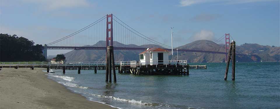 [The NOAA San Francisco Tide Station, in operation for more than 150 years. From NOAA]
NOS scientists advanced tidal recording systems as well as satellite imagery to monitor tides and water levels. These data are used to predict ocean behavior in order to protect our coasts and coastal communities. The Center for Operational Oceanographic Products and Services maintains a total of 210 permanent, continuously operating water level stations throughout the U.S., including the Great Lakes.
Part of each station is a recorder which sends an audio signal down a half-inch-wide sounding tube and measures the time it takes for the reflected signal to travel back from the water's surface. In addition to measuring tidal heights, these stations also record up to 11 different oceanographic and meteorological parameters including wind speed and direction, water current speed and direction, air and water temperature, and barometric pressure.
The stations collect data every six minutes with timing controlled by a Geostationary Operational Environmental Satellite (GOES). The stations also use these satellites to transmit their data every six minutes to NOAA headquarters. Field teams can quickly check and maintain the systems using laptop computers. In addition, all of the raw and processed data are available over the Internet. You can find out more on tides on this NOAA link.
Edited for WeatherNation by Meteorologist Mace Michaels
[The NOAA San Francisco Tide Station, in operation for more than 150 years. From NOAA]
NOS scientists advanced tidal recording systems as well as satellite imagery to monitor tides and water levels. These data are used to predict ocean behavior in order to protect our coasts and coastal communities. The Center for Operational Oceanographic Products and Services maintains a total of 210 permanent, continuously operating water level stations throughout the U.S., including the Great Lakes.
Part of each station is a recorder which sends an audio signal down a half-inch-wide sounding tube and measures the time it takes for the reflected signal to travel back from the water's surface. In addition to measuring tidal heights, these stations also record up to 11 different oceanographic and meteorological parameters including wind speed and direction, water current speed and direction, air and water temperature, and barometric pressure.
The stations collect data every six minutes with timing controlled by a Geostationary Operational Environmental Satellite (GOES). The stations also use these satellites to transmit their data every six minutes to NOAA headquarters. Field teams can quickly check and maintain the systems using laptop computers. In addition, all of the raw and processed data are available over the Internet. You can find out more on tides on this NOAA link.
Edited for WeatherNation by Meteorologist Mace Michaels
[Lowtide in Islesboro, Maine. From NOAA]
Imagine the ocean is shaped like a football pointing at the moon. The football’s pointed ends represent the parts of the Earth experiencing high tide and the football’s flat sides are the parts of the earth experiencing low tide. The point facing the moon is formed because the gravitational pull of the moon is strongest on whichever side of the Earth faces it. Gravity pulls the ocean towards the moon and high tide occurs.
The bulge on the far side of the Earth is caused by inertia. The water moving away from the moon resists the gravitational forces that attempt to pull it in the opposite direction. Because the gravitational pull of the moon is weaker on the far side of the Earth, inertia wins, the ocean bulges out and high tide occurs. As the Earth spins, different areas of the planet face the moon, and this rotation causes the tides to cycle around the planet.
[The two tidal bulges caused by inertia and gravity will rotate around the Earth as the moons position changes. These bulges represent high tides while the flat sides indicate low tides. From NOAA]
While some places have one high tide and one low tide per day, most coastal locations have two high tides and two low tides a day. These highs and lows typically aren't equal. This is why, in most places, using the phrase "high tide" might be unclear. There's actually high tide and higher high tide (and low and lower low tide).
If the Earth were a perfect sphere without large continents, and if the earth-moon-sun system were in perfect alignment, every place would get two equal high and low tides every day. However, the alignment of the moon and sun relative the earth, the presence of the continents, regional geography and features on the seafloor, among other factors, make tidal patterns more complex.
Around the world, there are three basic tidal patterns: semidiurnal, mixed, and diurnal. When both high tides are about equal to each other, and the low tides are also roughly equal, the pattern is called a semidiurnal tide. If the two highs and lows differ substantially, the pattern is called a mixed tide. Where there's only one high and one low tide a day, it's called a diurnal tide. One location can experience different tide patterns throughout the month.
[The NOAA San Francisco Tide Station, in operation for more than 150 years. From NOAA]
NOS scientists advanced tidal recording systems as well as satellite imagery to monitor tides and water levels. These data are used to predict ocean behavior in order to protect our coasts and coastal communities. The Center for Operational Oceanographic Products and Services maintains a total of 210 permanent, continuously operating water level stations throughout the U.S., including the Great Lakes.
Part of each station is a recorder which sends an audio signal down a half-inch-wide sounding tube and measures the time it takes for the reflected signal to travel back from the water's surface. In addition to measuring tidal heights, these stations also record up to 11 different oceanographic and meteorological parameters including wind speed and direction, water current speed and direction, air and water temperature, and barometric pressure.
The stations collect data every six minutes with timing controlled by a Geostationary Operational Environmental Satellite (GOES). The stations also use these satellites to transmit their data every six minutes to NOAA headquarters. Field teams can quickly check and maintain the systems using laptop computers. In addition, all of the raw and processed data are available over the Internet. You can find out more on tides on this NOAA link.
Edited for WeatherNation by Meteorologist Mace MichaelsAll Weather News
More
Fronts Continue To Spark Severe Weather Across the Plains
A cold front that brought record lows to the
18 Jul 2025 10:40 PM

Extreme Heat Impacts for the East Coast & South
Extreme heat continues to impact several area
18 Jul 2025 10:05 PM

Flooding Threat Remains Elevated in the East
A cold front pushing through the Eastern Seab
18 Jul 2025 9:10 PM

EF-2 Firenado from the Deer Creek Fire in Utah
A fire tornado was spotted near La Sal, Utah
18 Jul 2025 7:30 AM

Tropical System Brings Flood Risk to the Central Gulf
Time has run out for notable tropical develop
18 Jul 2025 3:05 AM

Heavy Rain, Flooding Threat Returns to Florida
Keep the rain boots handy in Florida - heavy
13 Jul 2025 12:50 PM

Severe Storm Risk Pushes into the Great Lakes, Ohio Valley
Friday was another busy day with severe weath
12 Jul 2025 8:00 PM