Top Weather Stories for Saturday, May 26th, 2018
Special Stories
26 May 2018 10:53 AM
Here are some of our top weather stories for Saturday, May 26th, 2018:
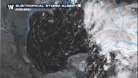
Tracking Subtropical Storm Alberto
 Severe weather is a threat once again across parts of the nation. In particular, today the intense severe weather is likely across the northern High Plains. This threat will shift east and expand over the next two day for the High Plains, with elevated storm chances stretching as far south as Kansas and Colorado and as far east as Michigan. There will also be elevated storms chances in place across the Southeastern United States Sunday and Monday Alberto begins to impact the region. Specifically, spin-up tornadoes are possible due to Alberto sweeping across parts of the Southeast over the next few days.
The (rec0rd) Heat is On
Severe weather is a threat once again across parts of the nation. In particular, today the intense severe weather is likely across the northern High Plains. This threat will shift east and expand over the next two day for the High Plains, with elevated storm chances stretching as far south as Kansas and Colorado and as far east as Michigan. There will also be elevated storms chances in place across the Southeastern United States Sunday and Monday Alberto begins to impact the region. Specifically, spin-up tornadoes are possible due to Alberto sweeping across parts of the Southeast over the next few days.
The (rec0rd) Heat is On
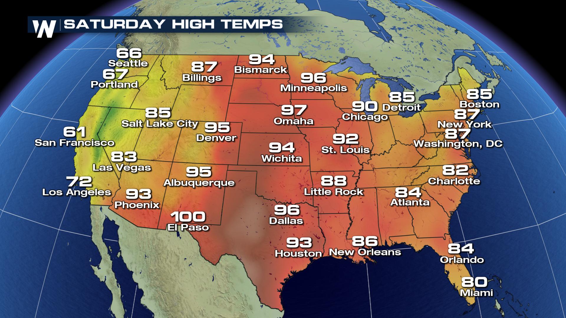 Temperatures will soar into the 90s and 100s across middle of the country today, through the weekend and even into next week. This extreme heat will likely lead to records falling for cities from north to south. Stay cool.
Tune into Weathernation for the latest weather information.
For WeatherNation, I am Meteorologist Marcus Walter.
Temperatures will soar into the 90s and 100s across middle of the country today, through the weekend and even into next week. This extreme heat will likely lead to records falling for cities from north to south. Stay cool.
Tune into Weathernation for the latest weather information.
For WeatherNation, I am Meteorologist Marcus Walter.
Subtropical Storm Alberto continues to spin in the western Caribbean but is still forecast to move north into the eastern Gulf of Mexico and strengthen into a tropical storm over the next day or so. This storm is likely to make landfall between Monday morning and Tuesday morning. Wide impacts along parts of the Gulf coast are expected. Heavy rain will be the biggest issue, with this rain leading to flooding concerns. There will likely be a storm surge with this system, increasing coastal flooding threat. Severe Weather Threat ContinuesGov. Rick Scott has declared a state of emergency in the Sunshine State, ahead of Alberto's arrival in the gulf coast. Here, our field correspondent Ben McMillan talks with a camper who must leave ahead of their scheduled trip because of the storm. Listen in. pic.twitter.com/wd1i8fP9Nw
— WeatherNation (@WeatherNation) May 26, 2018
Severe weather is a threat once again across parts of the nation. In particular, today the intense severe weather is likely across the northern High Plains. This threat will shift east and expand over the next two day for the High Plains, with elevated storm chances stretching as far south as Kansas and Colorado and as far east as Michigan. There will also be elevated storms chances in place across the Southeastern United States Sunday and Monday Alberto begins to impact the region. Specifically, spin-up tornadoes are possible due to Alberto sweeping across parts of the Southeast over the next few days.
The (rec0rd) Heat is On
Temperatures will soar into the 90s and 100s across middle of the country today, through the weekend and even into next week. This extreme heat will likely lead to records falling for cities from north to south. Stay cool.
Tune into Weathernation for the latest weather information.
For WeatherNation, I am Meteorologist Marcus Walter.All Weather News
More
Wildfire Outbreak in the Pacific Northwest
SPOKANE, WA - On Saturday, August 1st, the Ol
3 Aug 2026 1:55 AM

More Storms for the East Through Monday
A low-pressure system that moved through the
3 Aug 2026 1:50 AM


After Reaching Category 5, Genevieve Weakens in the Pacific
PacificGenevieve formed last Friday south of
3 Aug 2026 12:30 AM

Flooding, Severe Storms Target the Midwest Again
After an active week of storms across the nor
1 Aug 2026 1:40 AM

Flooding Risk Increases as Heavy Rain Targets the Tri-State Area
Tuesday, heavy rainfall moved across the Nort
30 Jul 2026 12:25 AM

Severe Weather: Energy From the Midwest Now in the Southeast
UPPER MIDWEST - Through Monday, dangerous tor
29 Jul 2026 10:30 PM