Tornado Concern in Iowa and Midwest Saturday
Top Stories
9 Jun 2018 3:55 PM
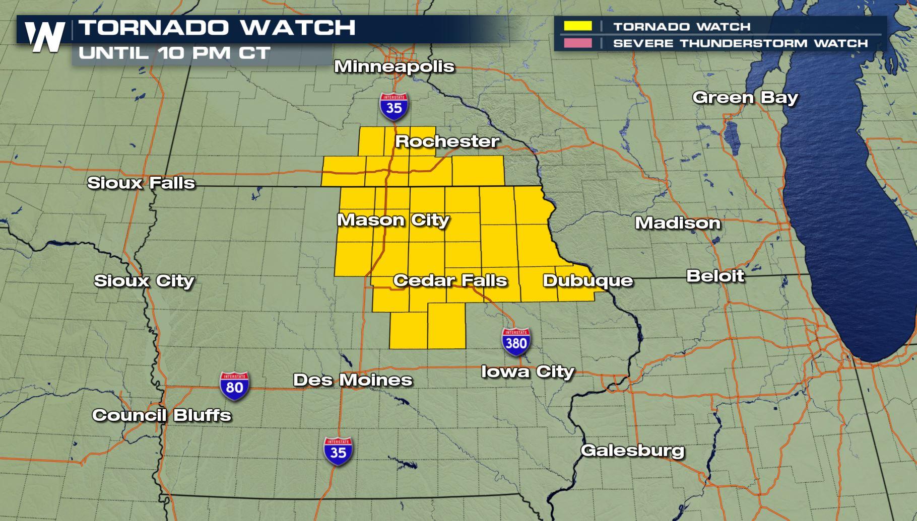
A tornado watch has been issued for parts of Minnesota and Iowa until 10 o'clock Saturday night.
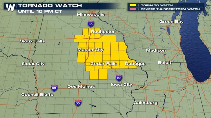 Valid now to 10 p.m. central Saturday, June 9
Thunderstorms capable of producing tornadoes will move to the east-southeast toward the Mississippi River Valley. These storms should move at a speed between 20 and 30 miles per hour, steadily but not overly fast.
A tornado was spotted northwest of Mason City, Iowa prompting a warning earlier Saturday.
https://twitter.com/WeatherNation/status/1005552402991206400
Thankfully that storm weakened as it approached the metro area.
https://twitter.com/WeatherNation/status/1005558942619992064
^^Again, these are previous alerts that *were* in effect for Iowa, not currently. It goes to show that storms can develop very quickly and transition through weakening and strengthening phases. That's why you should be weather ready and prepared!
Valid now to 10 p.m. central Saturday, June 9
Thunderstorms capable of producing tornadoes will move to the east-southeast toward the Mississippi River Valley. These storms should move at a speed between 20 and 30 miles per hour, steadily but not overly fast.
A tornado was spotted northwest of Mason City, Iowa prompting a warning earlier Saturday.
https://twitter.com/WeatherNation/status/1005552402991206400
Thankfully that storm weakened as it approached the metro area.
https://twitter.com/WeatherNation/status/1005558942619992064
^^Again, these are previous alerts that *were* in effect for Iowa, not currently. It goes to show that storms can develop very quickly and transition through weakening and strengthening phases. That's why you should be weather ready and prepared!
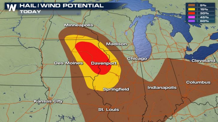 The hail and wind potential for the rest of Saturday, June 9 shows yellow and red areas with the greatest risk of damaging wind and/or hail, with less likely damage in the brown areas.
This isn't the only area we're watching this evening! A severe thunderstorm watch is in effect until 9 p.m. local time for northwest Montana.
The hail and wind potential for the rest of Saturday, June 9 shows yellow and red areas with the greatest risk of damaging wind and/or hail, with less likely damage in the brown areas.
This isn't the only area we're watching this evening! A severe thunderstorm watch is in effect until 9 p.m. local time for northwest Montana.
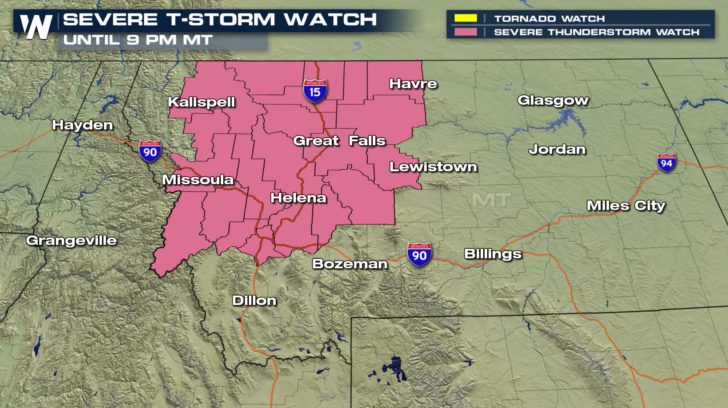 Valid through 9 p.m. MT Saturday, June 9
These thunderstorms will have a straight-line wind impact, rather than the higher threat of tornadoes in Iowa. Wind gusts may reach up to 75 miles per hour in the shaded areas, while hail may grow to the size of ping pong balls! These thunderstorms will move very quickly, to the east-northeast as fast as 55 mph!
Finally, these two areas aren't the only spots we're watching Saturday!
Valid through 9 p.m. MT Saturday, June 9
These thunderstorms will have a straight-line wind impact, rather than the higher threat of tornadoes in Iowa. Wind gusts may reach up to 75 miles per hour in the shaded areas, while hail may grow to the size of ping pong balls! These thunderstorms will move very quickly, to the east-northeast as fast as 55 mph!
Finally, these two areas aren't the only spots we're watching Saturday!
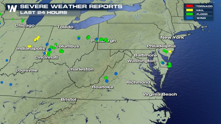 There have been several reports of flooding and flash flooding (green dots) across parts of the central and eastern U.S. Saturday.
Thunderstorms approaching the mid-Atlantic will drop heavy rain, possibly leading to pockets of flooding. Be aware of your surroundings throughout the rest of our weekend!
For WeatherNation, Meteorologist Steve Glazier
There have been several reports of flooding and flash flooding (green dots) across parts of the central and eastern U.S. Saturday.
Thunderstorms approaching the mid-Atlantic will drop heavy rain, possibly leading to pockets of flooding. Be aware of your surroundings throughout the rest of our weekend!
For WeatherNation, Meteorologist Steve Glazier
Valid now to 10 p.m. central Saturday, June 9
Thunderstorms capable of producing tornadoes will move to the east-southeast toward the Mississippi River Valley. These storms should move at a speed between 20 and 30 miles per hour, steadily but not overly fast.
A tornado was spotted northwest of Mason City, Iowa prompting a warning earlier Saturday.
https://twitter.com/WeatherNation/status/1005552402991206400
Thankfully that storm weakened as it approached the metro area.
https://twitter.com/WeatherNation/status/1005558942619992064
^^Again, these are previous alerts that *were* in effect for Iowa, not currently. It goes to show that storms can develop very quickly and transition through weakening and strengthening phases. That's why you should be weather ready and prepared!
The hail and wind potential for the rest of Saturday, June 9 shows yellow and red areas with the greatest risk of damaging wind and/or hail, with less likely damage in the brown areas.
This isn't the only area we're watching this evening! A severe thunderstorm watch is in effect until 9 p.m. local time for northwest Montana.
Valid through 9 p.m. MT Saturday, June 9
These thunderstorms will have a straight-line wind impact, rather than the higher threat of tornadoes in Iowa. Wind gusts may reach up to 75 miles per hour in the shaded areas, while hail may grow to the size of ping pong balls! These thunderstorms will move very quickly, to the east-northeast as fast as 55 mph!
Finally, these two areas aren't the only spots we're watching Saturday!
There have been several reports of flooding and flash flooding (green dots) across parts of the central and eastern U.S. Saturday.
Thunderstorms approaching the mid-Atlantic will drop heavy rain, possibly leading to pockets of flooding. Be aware of your surroundings throughout the rest of our weekend!
For WeatherNation, Meteorologist Steve GlazierAll Weather News
More
Fronts Continue To Spark Severe Weather Across the Plains
A cold front that brought record lows to the
18 Jul 2025 10:40 PM

Extreme Heat Impacts for the East Coast & South
Extreme heat continues to impact several area
18 Jul 2025 10:05 PM

Flooding Threat Remains Elevated in the East
A cold front pushing through the Eastern Seab
18 Jul 2025 9:10 PM

EF-2 Firenado from the Deer Creek Fire in Utah
A fire tornado was spotted near La Sal, Utah
18 Jul 2025 7:30 AM

Tropical System Brings Flood Risk to the Central Gulf
Time has run out for notable tropical develop
18 Jul 2025 3:05 AM

Heavy Rain, Flooding Threat Returns to Florida
Keep the rain boots handy in Florida - heavy
13 Jul 2025 12:50 PM

Severe Storm Risk Pushes into the Great Lakes, Ohio Valley
Friday was another busy day with severe weath
12 Jul 2025 8:00 PM