Tornado Q & A with NOAA’s Storm Prediction Center
Special Stories
6 Apr 2018 2:25 PM
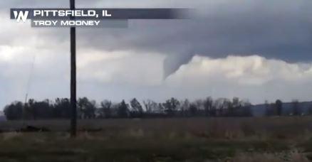
[A tornado is captured on camera in Pittsfield, Illinois Saturday. Credit: Troy Mooney]
From NOAA
No one knows more about predicting the awesome and destructive power of tornadoes than meteorologists at NOAA’s Storm Prediction Center located in Norman, Oklahoma, the heart of America’s Tornado Alley.
We sat down with Patrick Marsh, the Center’s warning coordination meteorologist, to talk about how NOAA forecasts tornadoes up to a week in advance – and what you can do when this kind of severe weather threatens your neighborhood.
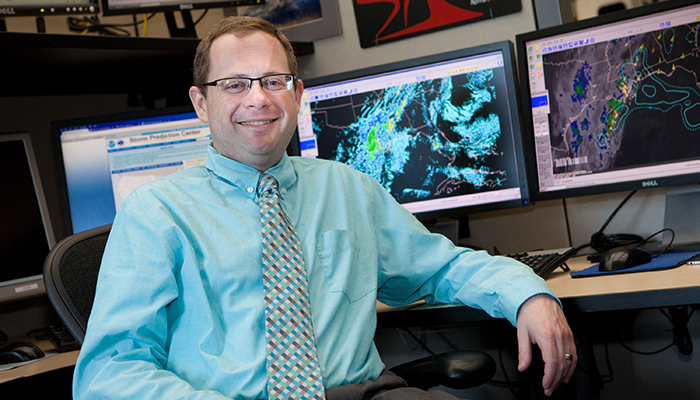 [Patrick Marsh is the warning coordination meteorologist at NOAA's Storm Prediction Center in Norman, Oklahoma. (James Murnan/NOAA)]
Q: First off, what does it take to forecast tornadoes? What are the atmospheric conditions that you look for?
Patrick: This is a question with no simple answer. It’s helpful to review how tornadoes develop. To get a tornado, we first need a thunderstorm. And to get a thunderstorm, we need areas where moisture is lifted into an unstable atmosphere.
When these ingredients are in place, we look for areas where the wind changes direction and speed with height, known as wind shear. The presence of wind shear allows for thunderstorms to rotate, and rotating thunderstorms are the ones most likely to produce tornadoes.
Creating the actual forecast involves analyzing lots of data: We use information from satellites and radars, along with surface and upper-air weather observations, to assess whether atmospheric conditions are ripe for tornado development. We consult computer models to see how conditions will change over time. Then we interpret all this information to make the official storm forecast.
[Patrick Marsh is the warning coordination meteorologist at NOAA's Storm Prediction Center in Norman, Oklahoma. (James Murnan/NOAA)]
Q: First off, what does it take to forecast tornadoes? What are the atmospheric conditions that you look for?
Patrick: This is a question with no simple answer. It’s helpful to review how tornadoes develop. To get a tornado, we first need a thunderstorm. And to get a thunderstorm, we need areas where moisture is lifted into an unstable atmosphere.
When these ingredients are in place, we look for areas where the wind changes direction and speed with height, known as wind shear. The presence of wind shear allows for thunderstorms to rotate, and rotating thunderstorms are the ones most likely to produce tornadoes.
Creating the actual forecast involves analyzing lots of data: We use information from satellites and radars, along with surface and upper-air weather observations, to assess whether atmospheric conditions are ripe for tornado development. We consult computer models to see how conditions will change over time. Then we interpret all this information to make the official storm forecast.
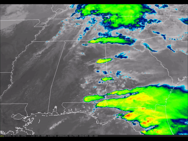 [On March 19, supercell thunderstorms produced tornadoes in northern Alabama, as visible from imagery from NOAA's GOES-16 satellite. (NOAA0}
Q: What is the difference between a tornado “watch” and a tornado “warning”?
Patrick: There’s an important difference! The Storm Prediction Center, in collaboration with your local NWS Forecast Office, will issue a tornado watch when tornadoes and other kinds of severe weather are possible in the next several hours. It does not mean tornadoes are imminent, just that you need to be alert and prepared to go to a safe shelter if a warning is issued or tornadoes form.
A tornado warning is issued when a tornado has been spotted or when Doppler radar shows a rotating thunderstorm that could spawn a tornado.
When a tornado warning is issued for your location, take immediate shelter. Generally, this means moving to the lowest floor of a house or building and putting as many walls between you and the tornado as possible, ideally in a tornado shelter or basement.
https://www.youtube.com/watch?v=x3V3HZBs1Y4
Q: When do tornadoes occur most frequently?
Patrick: Although the busiest months for tornadoes are April, May and June, the atmosphere doesn’t consult a calendar. If the ingredients for severe weather come together, tornadoes can happen anytime. It’s important to develop a severe weather plannow, and be ready to execute that plan when dangerous weather threatens.
Q: Why did you get interested in tornadoes?
Patrick: One of the first-ever tornadoes known to have been recorded on film happened near where I was born. So, I always believed I was destined to be involved in severe storms meteorology. It’s incredible that despite how much we know about tornadoes, there’s still so much more left to learn and discover.
Edited for WeatherNation by Meteorologist Mace Michaels
[On March 19, supercell thunderstorms produced tornadoes in northern Alabama, as visible from imagery from NOAA's GOES-16 satellite. (NOAA0}
Q: What is the difference between a tornado “watch” and a tornado “warning”?
Patrick: There’s an important difference! The Storm Prediction Center, in collaboration with your local NWS Forecast Office, will issue a tornado watch when tornadoes and other kinds of severe weather are possible in the next several hours. It does not mean tornadoes are imminent, just that you need to be alert and prepared to go to a safe shelter if a warning is issued or tornadoes form.
A tornado warning is issued when a tornado has been spotted or when Doppler radar shows a rotating thunderstorm that could spawn a tornado.
When a tornado warning is issued for your location, take immediate shelter. Generally, this means moving to the lowest floor of a house or building and putting as many walls between you and the tornado as possible, ideally in a tornado shelter or basement.
https://www.youtube.com/watch?v=x3V3HZBs1Y4
Q: When do tornadoes occur most frequently?
Patrick: Although the busiest months for tornadoes are April, May and June, the atmosphere doesn’t consult a calendar. If the ingredients for severe weather come together, tornadoes can happen anytime. It’s important to develop a severe weather plannow, and be ready to execute that plan when dangerous weather threatens.
Q: Why did you get interested in tornadoes?
Patrick: One of the first-ever tornadoes known to have been recorded on film happened near where I was born. So, I always believed I was destined to be involved in severe storms meteorology. It’s incredible that despite how much we know about tornadoes, there’s still so much more left to learn and discover.
Edited for WeatherNation by Meteorologist Mace Michaels
[Patrick Marsh is the warning coordination meteorologist at NOAA's Storm Prediction Center in Norman, Oklahoma. (James Murnan/NOAA)]
Q: First off, what does it take to forecast tornadoes? What are the atmospheric conditions that you look for?
Patrick: This is a question with no simple answer. It’s helpful to review how tornadoes develop. To get a tornado, we first need a thunderstorm. And to get a thunderstorm, we need areas where moisture is lifted into an unstable atmosphere.
When these ingredients are in place, we look for areas where the wind changes direction and speed with height, known as wind shear. The presence of wind shear allows for thunderstorms to rotate, and rotating thunderstorms are the ones most likely to produce tornadoes.
Creating the actual forecast involves analyzing lots of data: We use information from satellites and radars, along with surface and upper-air weather observations, to assess whether atmospheric conditions are ripe for tornado development. We consult computer models to see how conditions will change over time. Then we interpret all this information to make the official storm forecast.
[On March 19, supercell thunderstorms produced tornadoes in northern Alabama, as visible from imagery from NOAA's GOES-16 satellite. (NOAA0}
Q: What is the difference between a tornado “watch” and a tornado “warning”?
Patrick: There’s an important difference! The Storm Prediction Center, in collaboration with your local NWS Forecast Office, will issue a tornado watch when tornadoes and other kinds of severe weather are possible in the next several hours. It does not mean tornadoes are imminent, just that you need to be alert and prepared to go to a safe shelter if a warning is issued or tornadoes form.
A tornado warning is issued when a tornado has been spotted or when Doppler radar shows a rotating thunderstorm that could spawn a tornado.
When a tornado warning is issued for your location, take immediate shelter. Generally, this means moving to the lowest floor of a house or building and putting as many walls between you and the tornado as possible, ideally in a tornado shelter or basement.
https://www.youtube.com/watch?v=x3V3HZBs1Y4
Q: When do tornadoes occur most frequently?
Patrick: Although the busiest months for tornadoes are April, May and June, the atmosphere doesn’t consult a calendar. If the ingredients for severe weather come together, tornadoes can happen anytime. It’s important to develop a severe weather plannow, and be ready to execute that plan when dangerous weather threatens.
Q: Why did you get interested in tornadoes?
Patrick: One of the first-ever tornadoes known to have been recorded on film happened near where I was born. So, I always believed I was destined to be involved in severe storms meteorology. It’s incredible that despite how much we know about tornadoes, there’s still so much more left to learn and discover.
Edited for WeatherNation by Meteorologist Mace MichaelsAll Weather News
More
Severe Threat Marches East This Afternoon
UPPER MIDWEST - Through Monday, dangerous tor
28 Jul 2026 4:25 PM

Tropics: Fausto Heads towards Hawaii; Genevieve Cat 4 Hurricane
PacificTropical Storm Fausto continues to tra
28 Jul 2026 4:20 PM


Southeast Flood Risk Lingers Near Stalled Front
A stalled boundary over the Southeast will ke
25 Jul 2026 10:55 AM

Another Round of Storms Targets the Northeast
Tuesday brought severe weather again across p
23 Jul 2026 1:15 AM

Another Round of Severe Weather for the Upper Midwest and Great Lakes
The upper-level low train continues to keep t
21 Jul 2026 1:45 AM