Tornado Watch Issued for the Western Plains
Top Stories
28 May 2018 1:47 PM
Monday 3:15 p.m. CT Update: A severe thunderstorm watch has also been added for parts of Colorado and Wyoming until 10 p.m.
https://twitter.com/WeatherNation/status/1001195072094846976
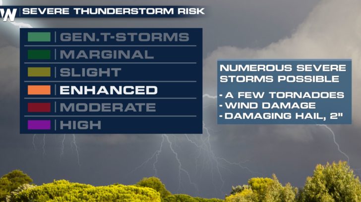
The threat for tornadoes is increasing across parts of Colorado, Kansas, and Nebraska this afternoon and evening.
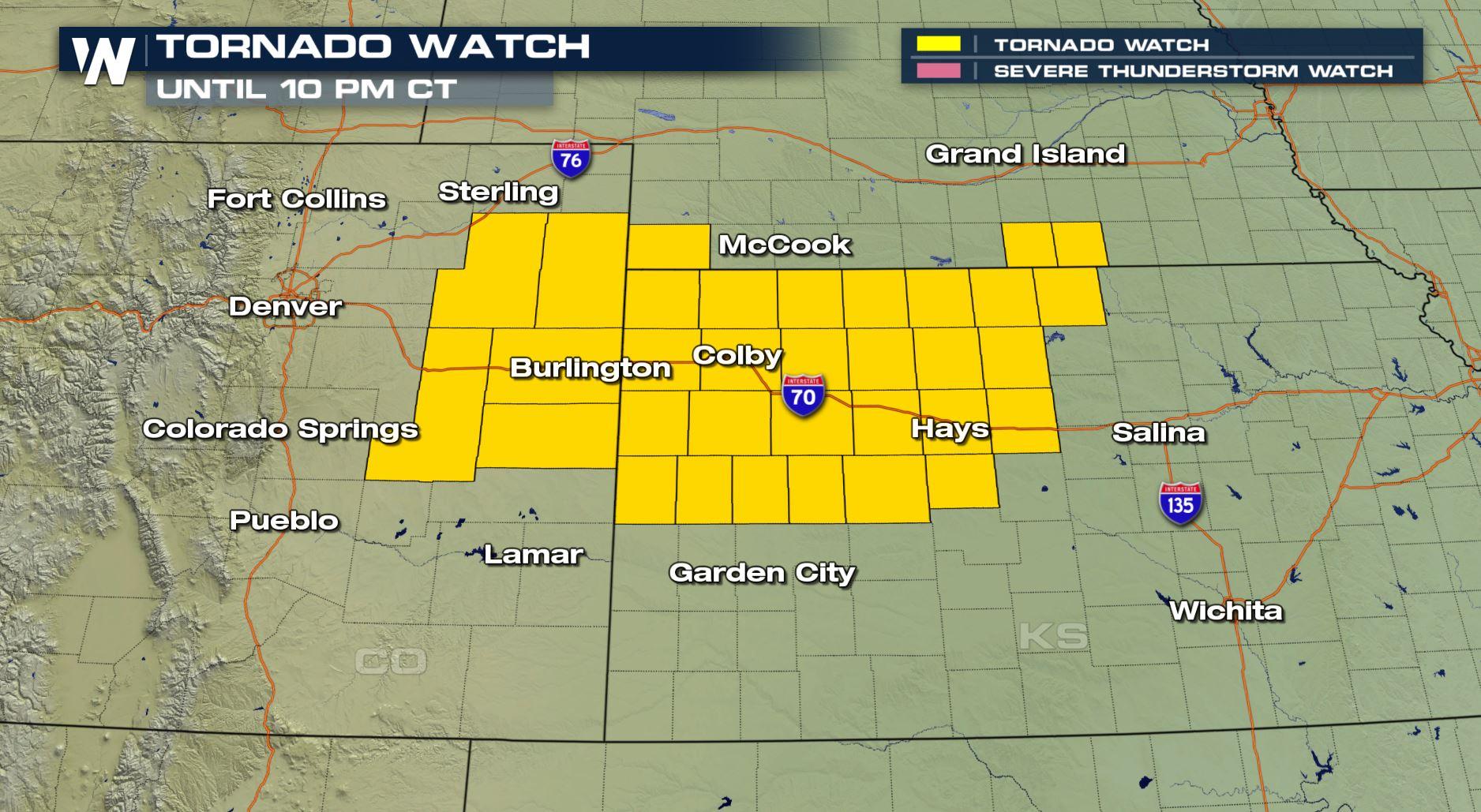
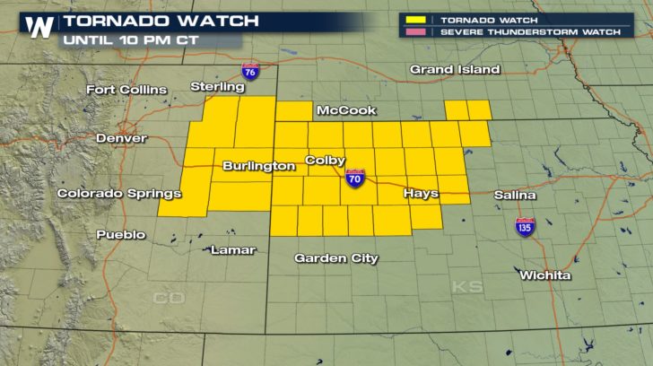 A tornado watch has been issued by the Storm Prediction Center (SPC) until 10 p.m. central Monday. This alert includes a large stretch of Interstate 70 from near Limon, Colorado to the east, beyond Hays, Kansas. It's an area in which SPC has forecast an "enhanced" risk of severe weather.
 Thunderstorms are already firing up right now, but will continue to do so deep into the evening. Warm, moist air is moving in from the south while cool, moist air is present to the north.
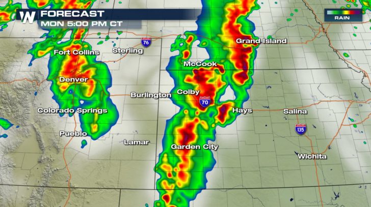 The forecast radar shows two distinct lines of thunderstorms on Monday afternoon. The line to the east will feature the highest chance of tornado activity while the line to the west (Colorado) has a decent chance at severe hail from the storms. These storms will move to the east-northeast fairly slowly, only between 15-30 mph.
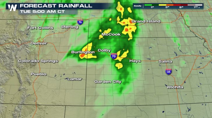 Due to the slow movement of the storms and training, (storms repeatedly going over the same area) temporary flooding will also be a weather-related hazard. These storms could put down up to four inches of rainfall before ending late Monday.
Stay with WeatherNation for all of the latest information.
For WeatherNation, Meteorologist Steve Glazier
Due to the slow movement of the storms and training, (storms repeatedly going over the same area) temporary flooding will also be a weather-related hazard. These storms could put down up to four inches of rainfall before ending late Monday.
Stay with WeatherNation for all of the latest information.
For WeatherNation, Meteorologist Steve Glazier
A tornado watch has been issued by the Storm Prediction Center (SPC) until 10 p.m. central Monday. This alert includes a large stretch of Interstate 70 from near Limon, Colorado to the east, beyond Hays, Kansas. It's an area in which SPC has forecast an "enhanced" risk of severe weather.
Thunderstorms are already firing up right now, but will continue to do so deep into the evening. Warm, moist air is moving in from the south while cool, moist air is present to the north.
The forecast radar shows two distinct lines of thunderstorms on Monday afternoon. The line to the east will feature the highest chance of tornado activity while the line to the west (Colorado) has a decent chance at severe hail from the storms. These storms will move to the east-northeast fairly slowly, only between 15-30 mph.
Due to the slow movement of the storms and training, (storms repeatedly going over the same area) temporary flooding will also be a weather-related hazard. These storms could put down up to four inches of rainfall before ending late Monday.
Stay with WeatherNation for all of the latest information.
For WeatherNation, Meteorologist Steve GlazierAll Weather News
More
Fronts Continue To Spark Severe Weather Across the Plains
A cold front that brought record lows to the
18 Jul 2025 10:40 PM

Extreme Heat Impacts for the East Coast & South
Extreme heat continues to impact several area
18 Jul 2025 10:05 PM

Flooding Threat Remains Elevated in the East
A cold front pushing through the Eastern Seab
18 Jul 2025 9:10 PM

EF-2 Firenado from the Deer Creek Fire in Utah
A fire tornado was spotted near La Sal, Utah
18 Jul 2025 7:30 AM

Tropical System Brings Flood Risk to the Central Gulf
Time has run out for notable tropical develop
18 Jul 2025 3:05 AM

Heavy Rain, Flooding Threat Returns to Florida
Keep the rain boots handy in Florida - heavy
13 Jul 2025 12:50 PM

Severe Storm Risk Pushes into the Great Lakes, Ohio Valley
Friday was another busy day with severe weath
12 Jul 2025 8:00 PM