Tracking Lightning from Space Using Satellites
Special Stories
18 Jul 2018 1:51 PM
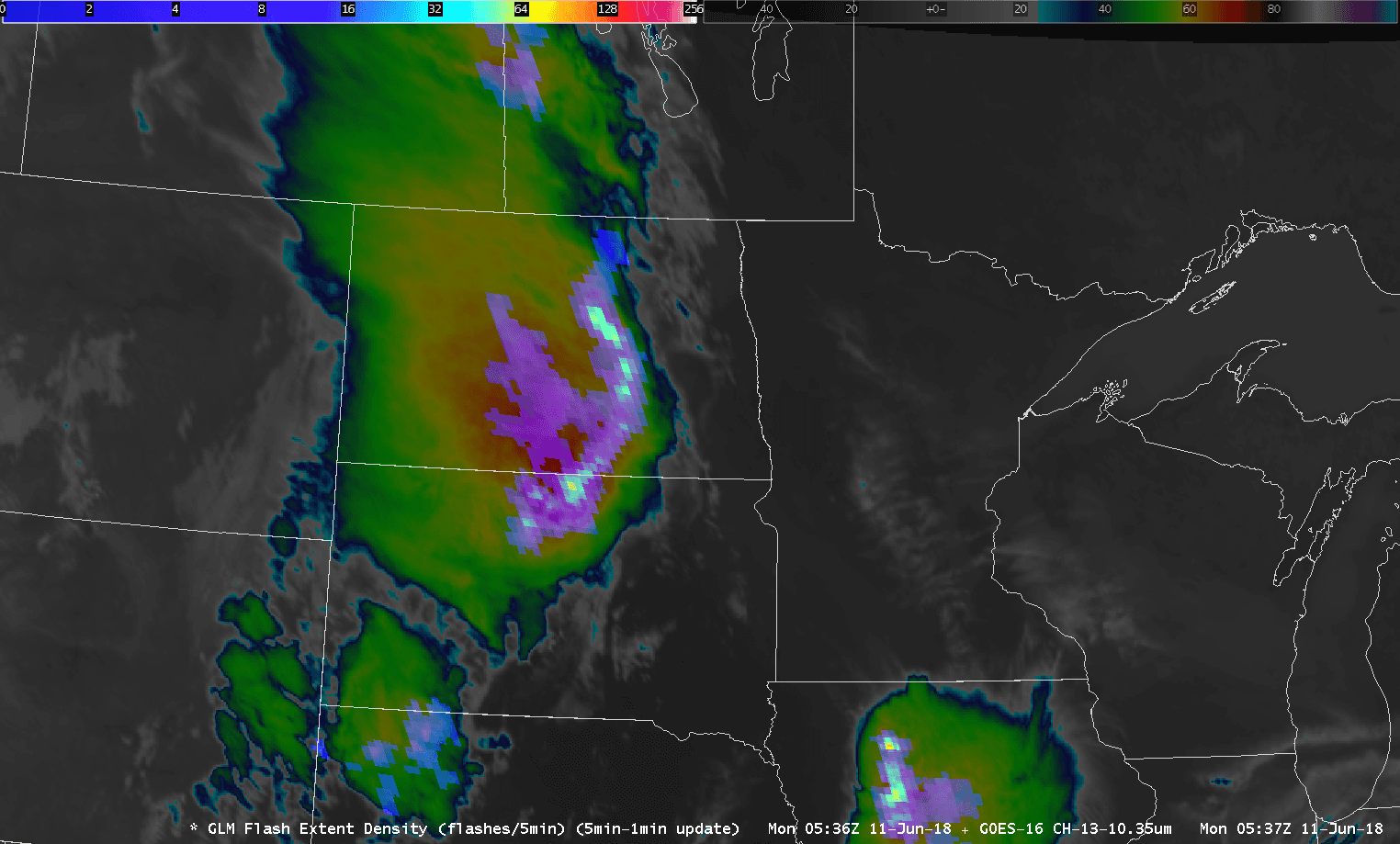
[This GOES East GLM imagery shows a high concentration of lightning flashes over the Northern Plains on June 11, 2018. (Image Credit: NOAA Virtual Lab)]
From NOAA
Lightning strikes, giant sparks of electricity in Earth’s atmosphere that are hotter than the surface of the sun, are a major hazard during thunderstorms. Knowing when and where lightning is occurring can tell us a lot about a storm - including its location, whether it’s intensifying, and if the storm is capable of producing severe weather.
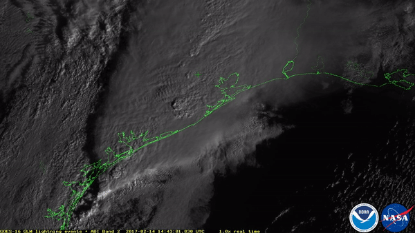
That’s where the Geostationary Lightning Mapper (GLM) comes in, which we showcased in an article a few months back. The groundbreaking instrument on-board the NOAA GOES East (GOES-16) satellite has allowed us to see lightning from space like never before, mapping cloud-to-ground, cloud-to-cloud, and intra-cloud lightning from more than 22,000 miles above Earth. The GLM is the first optical lightning detector on-board a satellite in geostationary orbit, and is the first of four instruments that will provide lightning mapping over most of the Western Hemisphere through 2036.
Until now, all those flashy lightning animations we've seen from the GOES East satellite haven't been used in operational weather forecasts. But that's about to change. On July 16, a new tool from the lightning mapper will be rolled out to National Weather Service forecast offices across the nation, giving forecasters a valuable new tool for tracking severe thunderstorms.
 While the National Lightning Detection Network uses more than 100 ground-based stations across the U.S. to detect cloud-to-ground and intra-cloud lightning flashes, the GLM offers much greater spatial coverage, and in many cases detects lightning flashes before ground-based lightning detection systems. The earlier we can detect lightning, the more time forecasters have to monitor a thunderstorm, and issue severe thunderstorm warnings.
Lightning data from the GLM can also help forecasters better pinpoint which parts of a thunderstorm are most severe based on the density (concentration) of flashes over a particular area. The new GLM “Flash Extent Density” product will allow the National Weather Service to see how frequently lightning is occurring over a certain area. When forecasters see the number of lightning strikes rapidly increasing, it’s a sign that a storm is intensifying and becoming more dangerous. This information gives forecasters better confidence when issuing weather warnings that ultimately improve public safety.
Recently, about two dozen forecasters participated in a pilot program to test these new lightning detection products while tracking thunderstorms around different parts of the country.
While the National Lightning Detection Network uses more than 100 ground-based stations across the U.S. to detect cloud-to-ground and intra-cloud lightning flashes, the GLM offers much greater spatial coverage, and in many cases detects lightning flashes before ground-based lightning detection systems. The earlier we can detect lightning, the more time forecasters have to monitor a thunderstorm, and issue severe thunderstorm warnings.
Lightning data from the GLM can also help forecasters better pinpoint which parts of a thunderstorm are most severe based on the density (concentration) of flashes over a particular area. The new GLM “Flash Extent Density” product will allow the National Weather Service to see how frequently lightning is occurring over a certain area. When forecasters see the number of lightning strikes rapidly increasing, it’s a sign that a storm is intensifying and becoming more dangerous. This information gives forecasters better confidence when issuing weather warnings that ultimately improve public safety.
Recently, about two dozen forecasters participated in a pilot program to test these new lightning detection products while tracking thunderstorms around different parts of the country.
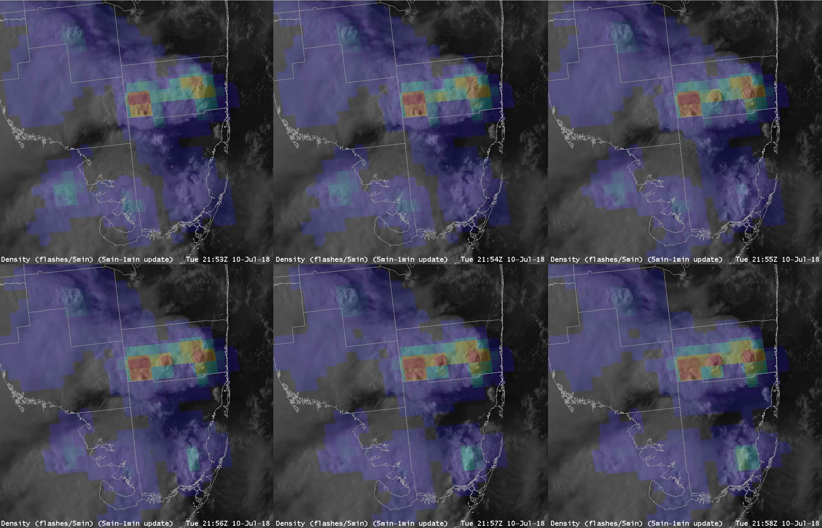 [This GOES East imagery shows the number of lightning flashes per minute over South Florida on July 10, 2018.]
In one case, forecasters at the NWS Huntsville, Alabama office, used the GLM Flash Extent Density product to help event planners decide whether a large outdoor country music concert would be safe. On June 1, 2018, a small multi-cell cluster of thunderstorms began moving in the direction of the concert venue, but began to split apart. By using the GLM data, forecasters could see that lightning was occurring both north and south of the outdoor event, as shown in the image below.
As the storm to the south weakened, the northern storm began to intensify. However, by combining GLM data with both infrared satellite imagery and ground-based radar data, forecasters could accurately determine that the storm was moving away from the outdoor concert, helping keep 30,000 people out of harm’s way.
[This GOES East imagery shows the number of lightning flashes per minute over South Florida on July 10, 2018.]
In one case, forecasters at the NWS Huntsville, Alabama office, used the GLM Flash Extent Density product to help event planners decide whether a large outdoor country music concert would be safe. On June 1, 2018, a small multi-cell cluster of thunderstorms began moving in the direction of the concert venue, but began to split apart. By using the GLM data, forecasters could see that lightning was occurring both north and south of the outdoor event, as shown in the image below.
As the storm to the south weakened, the northern storm began to intensify. However, by combining GLM data with both infrared satellite imagery and ground-based radar data, forecasters could accurately determine that the storm was moving away from the outdoor concert, helping keep 30,000 people out of harm’s way.
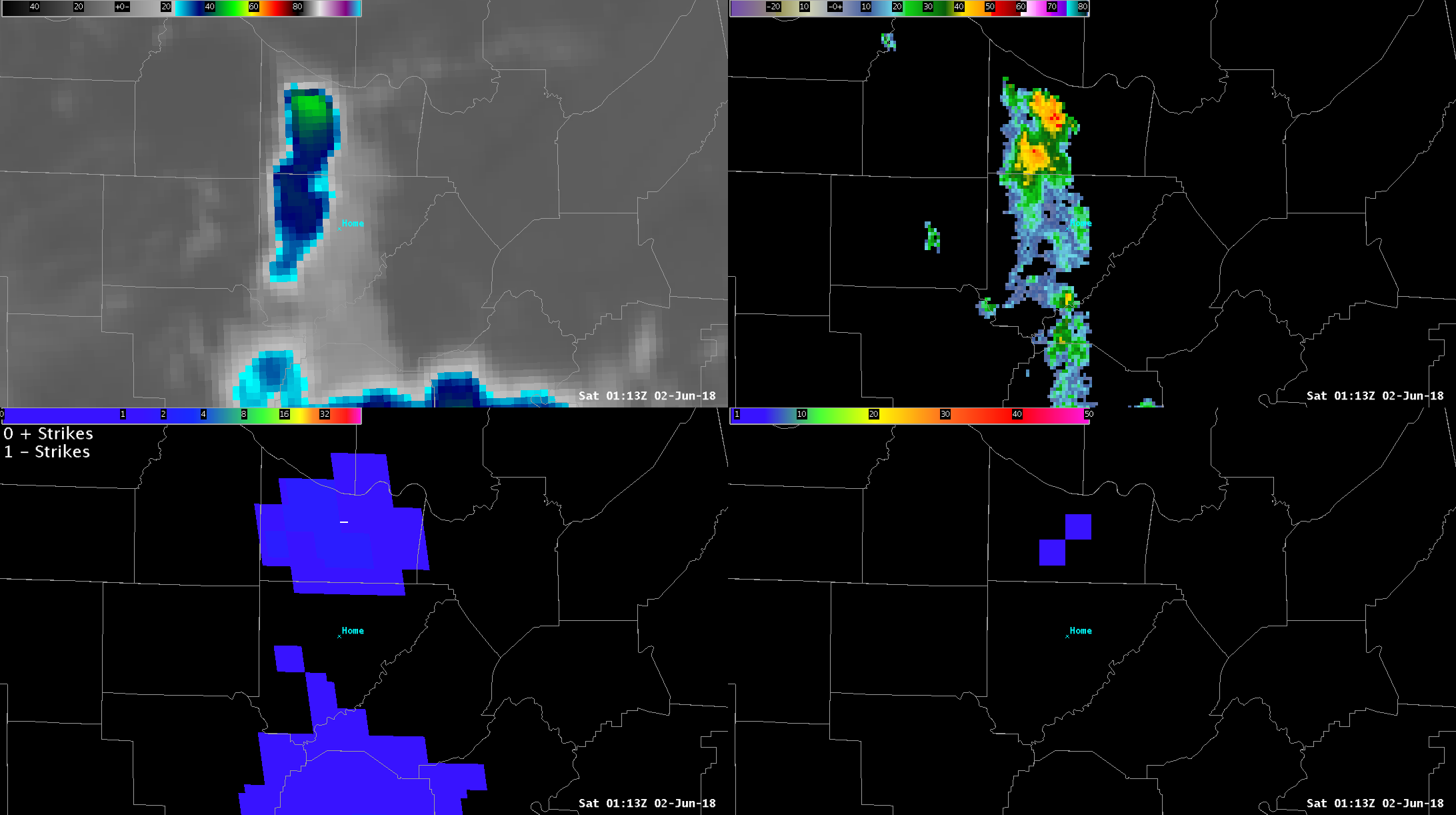 [The bottom left panel of this image maps the location of lightning from the GLM Flash Extent Density product. The concert location is marked “Home” in light blue. (Credit: NOAA GLM Virtual Lab)]
Forecasters participating in the pilot program emphasized that the new Flash Extent Density product can capture the areal extent of lightning better than traditional ground-based networks. Lightning can strike as far as 100 miles away from a thunderstorm, so knowing where it is occurring helps meteorologists better communicate the dangers of lightning flashes to both emergency managers and the public. This is especially important for aviation safety, which relies on accurately detecting areas of lightning to keep planes safe both on the ground and in the air.
The Flash Extent Density product is one of three new lightning mapping tools developed for the National Weather Service. Later this year, additional GLM products that measure the average lightning flash area and total optical energy will also become operational at forecast offices around the country.
Edited for WeatherNation by Meteorologist Mace Michaels
[The bottom left panel of this image maps the location of lightning from the GLM Flash Extent Density product. The concert location is marked “Home” in light blue. (Credit: NOAA GLM Virtual Lab)]
Forecasters participating in the pilot program emphasized that the new Flash Extent Density product can capture the areal extent of lightning better than traditional ground-based networks. Lightning can strike as far as 100 miles away from a thunderstorm, so knowing where it is occurring helps meteorologists better communicate the dangers of lightning flashes to both emergency managers and the public. This is especially important for aviation safety, which relies on accurately detecting areas of lightning to keep planes safe both on the ground and in the air.
The Flash Extent Density product is one of three new lightning mapping tools developed for the National Weather Service. Later this year, additional GLM products that measure the average lightning flash area and total optical energy will also become operational at forecast offices around the country.
Edited for WeatherNation by Meteorologist Mace Michaels
While the National Lightning Detection Network uses more than 100 ground-based stations across the U.S. to detect cloud-to-ground and intra-cloud lightning flashes, the GLM offers much greater spatial coverage, and in many cases detects lightning flashes before ground-based lightning detection systems. The earlier we can detect lightning, the more time forecasters have to monitor a thunderstorm, and issue severe thunderstorm warnings.
Lightning data from the GLM can also help forecasters better pinpoint which parts of a thunderstorm are most severe based on the density (concentration) of flashes over a particular area. The new GLM “Flash Extent Density” product will allow the National Weather Service to see how frequently lightning is occurring over a certain area. When forecasters see the number of lightning strikes rapidly increasing, it’s a sign that a storm is intensifying and becoming more dangerous. This information gives forecasters better confidence when issuing weather warnings that ultimately improve public safety.
Recently, about two dozen forecasters participated in a pilot program to test these new lightning detection products while tracking thunderstorms around different parts of the country.
[This GOES East imagery shows the number of lightning flashes per minute over South Florida on July 10, 2018.]
In one case, forecasters at the NWS Huntsville, Alabama office, used the GLM Flash Extent Density product to help event planners decide whether a large outdoor country music concert would be safe. On June 1, 2018, a small multi-cell cluster of thunderstorms began moving in the direction of the concert venue, but began to split apart. By using the GLM data, forecasters could see that lightning was occurring both north and south of the outdoor event, as shown in the image below.
As the storm to the south weakened, the northern storm began to intensify. However, by combining GLM data with both infrared satellite imagery and ground-based radar data, forecasters could accurately determine that the storm was moving away from the outdoor concert, helping keep 30,000 people out of harm’s way.
[The bottom left panel of this image maps the location of lightning from the GLM Flash Extent Density product. The concert location is marked “Home” in light blue. (Credit: NOAA GLM Virtual Lab)]
Forecasters participating in the pilot program emphasized that the new Flash Extent Density product can capture the areal extent of lightning better than traditional ground-based networks. Lightning can strike as far as 100 miles away from a thunderstorm, so knowing where it is occurring helps meteorologists better communicate the dangers of lightning flashes to both emergency managers and the public. This is especially important for aviation safety, which relies on accurately detecting areas of lightning to keep planes safe both on the ground and in the air.
The Flash Extent Density product is one of three new lightning mapping tools developed for the National Weather Service. Later this year, additional GLM products that measure the average lightning flash area and total optical energy will also become operational at forecast offices around the country.
Edited for WeatherNation by Meteorologist Mace MichaelsAll Weather News
More
Fronts Continue To Spark Severe Weather Across the Plains
A cold front that brought record lows to the
18 Jul 2025 10:40 PM

Extreme Heat Impacts for the East Coast & South
Extreme heat continues to impact several area
18 Jul 2025 10:05 PM

Flooding Threat Remains Elevated in the East
A cold front pushing through the Eastern Seab
18 Jul 2025 9:10 PM

EF-2 Firenado from the Deer Creek Fire in Utah
A fire tornado was spotted near La Sal, Utah
18 Jul 2025 7:30 AM

Tropical System Brings Flood Risk to the Central Gulf
Time has run out for notable tropical develop
18 Jul 2025 3:05 AM

Heavy Rain, Flooding Threat Returns to Florida
Keep the rain boots handy in Florida - heavy
13 Jul 2025 12:50 PM

Severe Storm Risk Pushes into the Great Lakes, Ohio Valley
Friday was another busy day with severe weath
12 Jul 2025 8:00 PM