Tropical Development Likely Near Southeast Coast
Special Stories
24 Aug 2019 6:52 AM
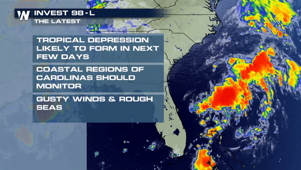
A closed circulation meandering off the southern coast of Florida (invest 98-L) will push north and likely become a tropical depression this weekend. Interests along the southeast U.S. coast should continue to monitor this disturbance and the impacts it may bring.
 Right now this is nothing more than low pressure center. It is disorganized and not producing life-threatening impacts. However there are plenty of downpours and thunderstorms associated with the tropical wave. While it is disorganized now, it could become better organized in the coming days. It will likely reach Tropical Depression very soon, getting even stronger over the open waters of the Atlantic into early this week.
The National Hurricane Center's latest update as of 2 p.m. ET Saturday:
Right now this is nothing more than low pressure center. It is disorganized and not producing life-threatening impacts. However there are plenty of downpours and thunderstorms associated with the tropical wave. While it is disorganized now, it could become better organized in the coming days. It will likely reach Tropical Depression very soon, getting even stronger over the open waters of the Atlantic into early this week.
The National Hurricane Center's latest update as of 2 p.m. ET Saturday:
Invest 98-L
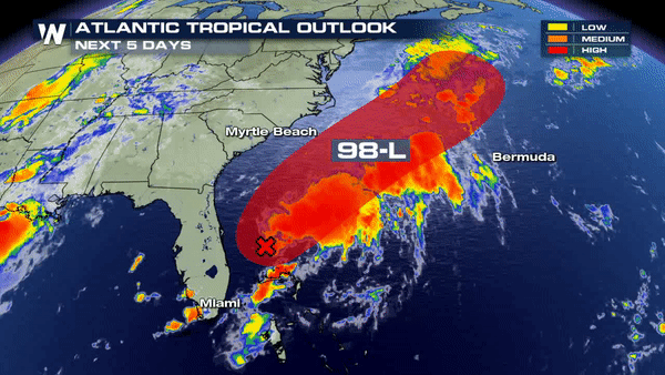
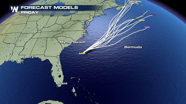
Short for investigation, invest 98-L was identified on Thursday. It was given the title Invest 98-L so that computer models could be initiated on the low. Those computer models are what you see below, often called spaghetti models plots. The slow moving front draped across the southeast will push the low to the northeast, where a trough in the jet stream will keep it out into the Atlantic.
Right now this is nothing more than low pressure center. It is disorganized and not producing life-threatening impacts. However there are plenty of downpours and thunderstorms associated with the tropical wave. While it is disorganized now, it could become better organized in the coming days. It will likely reach Tropical Depression very soon, getting even stronger over the open waters of the Atlantic into early this week.
The National Hurricane Center's latest update as of 2 p.m. ET Saturday:
"Showers and thunderstorms remain disorganized in association with a
trough of low pressure that extends from the southern Florida
peninsula northeastward over the western Atlantic for a few hundred
miles.  Environmental conditions appear conducive for gradual
development, and a tropical or subtropical depression is likely to
form within the next few days while the system moves slowly
northeastward well offshore of the southeastern United States.
Interests along the coasts of South and North Carolina should
continue to monitor the progress of this system.  An Air Force
Reserve Hurricane Hunter aircraft is scheduled to investigate the
disturbance this afternoon, if necessary."
Source: https://www.nhc.noaa.gov/ Continue to monitor the progression of this tropical wave each day, especially if you live along the southeast coast.
All Weather News
More
Severe Storms Target the Midwest to the Northeast
UPPER MIDWEST - Dangerous tornadoes have alre
28 Jul 2026 1:45 AM

Tropics: Fausto Heads towards Hawaii; Genevieve Cat 4 Hurricane
PacificHurricane Fausto continues to track we
28 Jul 2026 1:45 AM


Southeast Flood Risk Lingers Near Stalled Front
A stalled boundary over the Southeast will ke
25 Jul 2026 10:55 AM

Another Round of Storms Targets the Northeast
Tuesday brought severe weather again across p
23 Jul 2026 1:15 AM

Another Round of Severe Weather for the Upper Midwest and Great Lakes
The upper-level low train continues to keep t
21 Jul 2026 1:45 AM