U.S. High-Tide Flooding Continues to Increase
Special Stories
21 Jul 2020 2:16 AM
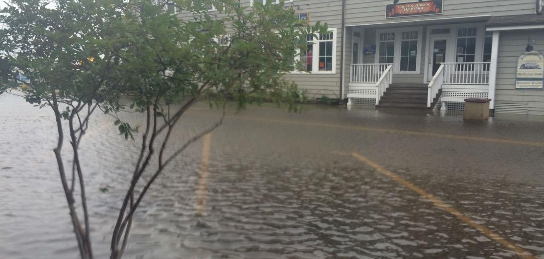
[Front Street in Beaufort, North Carolina, during a so-called king tide. High tide flooding causes frequent road closures, overwhelmed storm drains and compromised infrastructure. (Christine Burns / NC King Tides Project UNC-IMS]
[Written by NOAA] Coastal communities across the U.S. continued to see record-setting high-tide flooding last year, forcing their residents and visitors to deal with flooded shorelines, streets and basements — a trend that is expected to continue into 2021. The elevated water levels affected coastal economies, tourism and crucial infrastructure like waste and stormwater systems, according to a new NOAA report.
 High-tide flooding, often referred to as "nuisance" or “sunny day” flooding, is increasingly common due to years of relative sea level increases. It occurs when tides reach anywhere from 1.75 to 2 feet above the daily average high tide and start spilling onto streets or bubbling up from storm drains. As sea level rise continues, damaging floods that decades ago happened only during a storm now happen more regularly, such as during a full-moon tide or with a change in prevailing winds or currents.
“America’s coastal communities and their economies are suffering from the effects of high tide flooding, and it’s only going to increase in the future,” said Nicole LeBoeuf, acting director of NOAA’s National Ocean Service. “NOAA is committed to working with coastal communities to provide the information and data they need to tackle the problem of high tide flooding, both now and in the coming years as sea levels continue to rise.”
High-tide flooding, often referred to as "nuisance" or “sunny day” flooding, is increasingly common due to years of relative sea level increases. It occurs when tides reach anywhere from 1.75 to 2 feet above the daily average high tide and start spilling onto streets or bubbling up from storm drains. As sea level rise continues, damaging floods that decades ago happened only during a storm now happen more regularly, such as during a full-moon tide or with a change in prevailing winds or currents.
“America’s coastal communities and their economies are suffering from the effects of high tide flooding, and it’s only going to increase in the future,” said Nicole LeBoeuf, acting director of NOAA’s National Ocean Service. “NOAA is committed to working with coastal communities to provide the information and data they need to tackle the problem of high tide flooding, both now and in the coming years as sea levels continue to rise.”
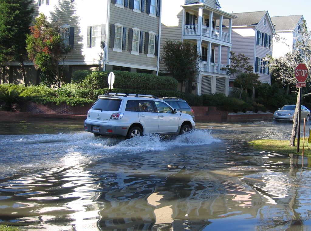 [Flooding during a perigean spring tide in Charleston, SC. From NOAA]
In 2019, the Southeast saw a 3-fold increase in flooding days compared to the year 2000. For example, Charleston, S.C., had 13 days where flooding reached damaging levels, compared to only two days typical in 2000. Along the Western Gulf, percentage increases were the highest, greater than 5-fold. In Texas, Sabine Pass and Corpus Christi had 21 and 18 flooding days in 2019, and in 2000 those locations would typically only experience about one and three days, respectively.
"As a Chesapeake Bay resident, I see the flooding first hand and it is getting worse. Records seem to be set every year," said William Sweet, Ph.D., an oceanographer for NOAA’s National Ocean Service and lead author of the report. "Communities are straddled with this growing problem. Fortunately, NOAA’s tide gauge network is keeping a close watch and helping us provide guidance about the disruptive flooding that is likely next year and for decades to come."
[Flooding during a perigean spring tide in Charleston, SC. From NOAA]
In 2019, the Southeast saw a 3-fold increase in flooding days compared to the year 2000. For example, Charleston, S.C., had 13 days where flooding reached damaging levels, compared to only two days typical in 2000. Along the Western Gulf, percentage increases were the highest, greater than 5-fold. In Texas, Sabine Pass and Corpus Christi had 21 and 18 flooding days in 2019, and in 2000 those locations would typically only experience about one and three days, respectively.
"As a Chesapeake Bay resident, I see the flooding first hand and it is getting worse. Records seem to be set every year," said William Sweet, Ph.D., an oceanographer for NOAA’s National Ocean Service and lead author of the report. "Communities are straddled with this growing problem. Fortunately, NOAA’s tide gauge network is keeping a close watch and helping us provide guidance about the disruptive flooding that is likely next year and for decades to come."
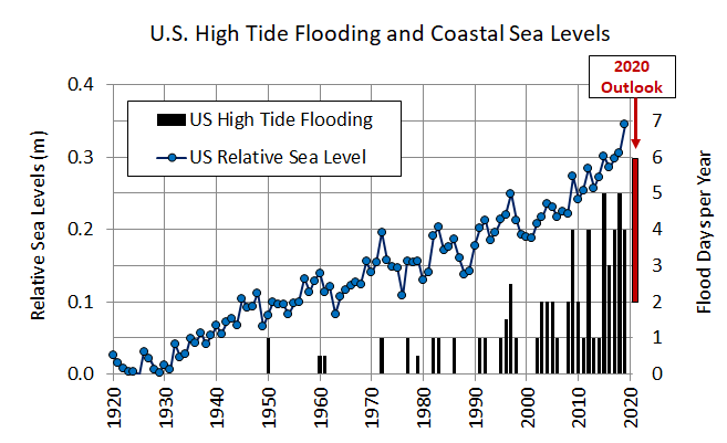
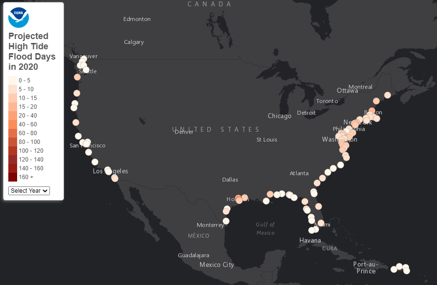 Sweet and his co-authors project that from May 2020 to April 2021, the national high tide flood frequency is expected to accelerate, with U.S. coastal communities seeing an average of 2 to 6 days of flooding in the coming year. Communities along the northeast and western Gulf coasts are projected to see even more days of flooding.
By 2030, long-term projections show seven to 15 days of high-tide flooding for coastal communities nationally. By 2050, that rises to 25 to 75 days, suggesting high tide flood levels may become the new high tide. These long term outlooks are based on the range of relative sea level rise, using 2 scenarios of the Fourth National Climate Assessment considered more likely to occur by 2030 and 2050 – Intermediate Low and Intermediate.
NOAA maintains ocean observing infrastructure, including more than 200 permanent water level stations on the U.S. coasts and Great Lakes, and is the nation’s authoritative source for historic and real-time data, forecasts, predictions, and scientific analyses that protect life, the economy and the environment on the coast.
Sweet and his co-authors project that from May 2020 to April 2021, the national high tide flood frequency is expected to accelerate, with U.S. coastal communities seeing an average of 2 to 6 days of flooding in the coming year. Communities along the northeast and western Gulf coasts are projected to see even more days of flooding.
By 2030, long-term projections show seven to 15 days of high-tide flooding for coastal communities nationally. By 2050, that rises to 25 to 75 days, suggesting high tide flood levels may become the new high tide. These long term outlooks are based on the range of relative sea level rise, using 2 scenarios of the Fourth National Climate Assessment considered more likely to occur by 2030 and 2050 – Intermediate Low and Intermediate.
NOAA maintains ocean observing infrastructure, including more than 200 permanent water level stations on the U.S. coasts and Great Lakes, and is the nation’s authoritative source for historic and real-time data, forecasts, predictions, and scientific analyses that protect life, the economy and the environment on the coast.
The report, 2019 State of High-Tide Flooding and 2020 Outlook, documents changes in high-tide flooding patterns from May 2019 to April 2020 at 98 NOAA tidal gauges along the U.S. coast, and provides a flooding outlook for these locations for the coming meteorological year, May 2020 to April 2021, and projections for the next several decades
High-tide flooding, often referred to as "nuisance" or “sunny day” flooding, is increasingly common due to years of relative sea level increases. It occurs when tides reach anywhere from 1.75 to 2 feet above the daily average high tide and start spilling onto streets or bubbling up from storm drains. As sea level rise continues, damaging floods that decades ago happened only during a storm now happen more regularly, such as during a full-moon tide or with a change in prevailing winds or currents.
“America’s coastal communities and their economies are suffering from the effects of high tide flooding, and it’s only going to increase in the future,” said Nicole LeBoeuf, acting director of NOAA’s National Ocean Service. “NOAA is committed to working with coastal communities to provide the information and data they need to tackle the problem of high tide flooding, both now and in the coming years as sea levels continue to rise.”
According to the report, U.S. coastal communities saw a median flood frequency of four days in 2019, just shy of the record set last year. However, 19 locations along the East and Gulf coasts set or tied records where rapidly increasing trends in high tide flooding have emerged.
[Flooding during a perigean spring tide in Charleston, SC. From NOAA]
In 2019, the Southeast saw a 3-fold increase in flooding days compared to the year 2000. For example, Charleston, S.C., had 13 days where flooding reached damaging levels, compared to only two days typical in 2000. Along the Western Gulf, percentage increases were the highest, greater than 5-fold. In Texas, Sabine Pass and Corpus Christi had 21 and 18 flooding days in 2019, and in 2000 those locations would typically only experience about one and three days, respectively.
"As a Chesapeake Bay resident, I see the flooding first hand and it is getting worse. Records seem to be set every year," said William Sweet, Ph.D., an oceanographer for NOAA’s National Ocean Service and lead author of the report. "Communities are straddled with this growing problem. Fortunately, NOAA’s tide gauge network is keeping a close watch and helping us provide guidance about the disruptive flooding that is likely next year and for decades to come."
Sweet and his co-authors project that from May 2020 to April 2021, the national high tide flood frequency is expected to accelerate, with U.S. coastal communities seeing an average of 2 to 6 days of flooding in the coming year. Communities along the northeast and western Gulf coasts are projected to see even more days of flooding.
By 2030, long-term projections show seven to 15 days of high-tide flooding for coastal communities nationally. By 2050, that rises to 25 to 75 days, suggesting high tide flood levels may become the new high tide. These long term outlooks are based on the range of relative sea level rise, using 2 scenarios of the Fourth National Climate Assessment considered more likely to occur by 2030 and 2050 – Intermediate Low and Intermediate.
NOAA maintains ocean observing infrastructure, including more than 200 permanent water level stations on the U.S. coasts and Great Lakes, and is the nation’s authoritative source for historic and real-time data, forecasts, predictions, and scientific analyses that protect life, the economy and the environment on the coast.All Weather News
More
Fronts Continue To Spark Severe Weather Across the Plains
A cold front that brought record lows to the
18 Jul 2025 10:40 PM

Extreme Heat Impacts for the East Coast & South
Extreme heat continues to impact several area
18 Jul 2025 10:05 PM

Flooding Threat Remains Elevated in the East
A cold front pushing through the Eastern Seab
18 Jul 2025 9:10 PM

EF-2 Firenado from the Deer Creek Fire in Utah
A fire tornado was spotted near La Sal, Utah
18 Jul 2025 7:30 AM

Tropical System Brings Flood Risk to the Central Gulf
Time has run out for notable tropical develop
18 Jul 2025 3:05 AM

Heavy Rain, Flooding Threat Returns to Florida
Keep the rain boots handy in Florida - heavy
13 Jul 2025 12:50 PM

Severe Storm Risk Pushes into the Great Lakes, Ohio Valley
Friday was another busy day with severe weath
12 Jul 2025 8:00 PM