Updated January Forecast from NOAA's Climate Prediction Center
Special Stories
3 Jan 2019 8:14 AM
Earlier this week, NOAA's Climate Prediction Center updated their outlook for January. The forecast continues to highlight warmer than average temperatures across the West, with an added extension into the Upper Midwest. Below normal temperatures are now expected in New England, but no longer in the Tennessee Valley.
Little change was made to the precipitation forecast, with wetter than normal weather expected throughout the southern tier of the nation and below normal conditions across the north.
https://twitter.com/NWSCPC/status/1079831539934994432
Good news in the drought forecast to start 2019. Conditions should continue to improve over the Southwest, with no development areas expected.
https://twitter.com/NWSCPC/status/1079832000356368384
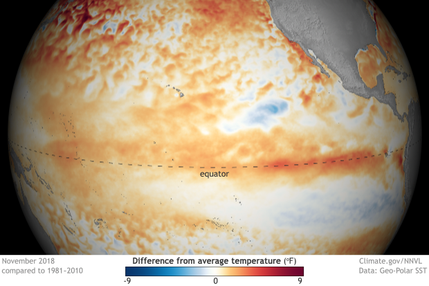
The main forecast influences were global pattern trends and long range model forecasts. An extensively discussed El Nino is underway in the Pacific Ocean, but the atmosphere has been slow to respond. Observed sea surface temperatures in the Pacific are warmer than normal as expected, with computer models expecting this to continue. Right now, the overall global pattern resembles neutral conditions. Based on the latest observations and model forecasts, the CPC still indicates a greater than 80 percent chance for El Nino from January to March and 70 percent that it persists through May.
 [November 2018 sea surface temperature departure from the 1981-2010 average. Graphic by NOAA Climate; data from NOAA’s Environmental Visualization Lab.]
For WeatherNation: Meteorologist Mace Michaels
 [November 2018 sea surface temperature departure from the 1981-2010 average. Graphic by NOAA Climate; data from NOAA’s Environmental Visualization Lab.]
For WeatherNation: Meteorologist Mace Michaels
[November 2018 sea surface temperature departure from the 1981-2010 average. Graphic by NOAA Climate; data from NOAA’s Environmental Visualization Lab.]
For WeatherNation: Meteorologist Mace MichaelsAll Weather News
More