Updated March Outlook from NOAA's Climate Prediction Center
Special Stories
3 Mar 2020 2:00 AM
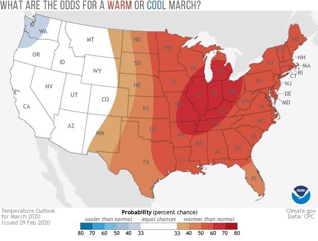
[From NOAA, written by Tom Di Liberto] Welcome to meteorological spring! March kickstarts the transition season for many across the United States, and NOAA’s Climate Prediction Center has issued its monthly outlook for March 2020 temperature and precipitation. As a reminder, these outlooks don’t predict the actual numerical temperature or the exact amount of precipitation. Instead, they predict the probability that monthly temperatures and precipitation will be in the upper or lower third of the climatological record (defined as the 1981-2010 period) for a given location. Darker colors refer to a higher chance, not more extreme conditions.
The highest chance for above-average temperatures during March is located across the lower Mississippi Valley from northeastern Arkansas and western Tennessee to the lower Great Lakes in Michigan and southern Wisconsin. However, the entire central and eastern parts of the contiguous United States have a tilt in the odds toward above-average temperatures during March. Only the Pacific Northwest sees probabilities tilted towards a cooler-than-average March. This marks significant changes from the outlook issued a couple of weeks ago, which had below average temperatures from the Plains to the East Coast.
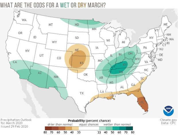 The increased chance for above-average temperatures in the Ohio Valley region coincides with an increased probability for a wetter March, with the highest odds in the Tennessee Valley. Another area where the odds are tilted toward a wetter March is along the US/Mexico border from southern California to western Texas. February in California was quite dry, so above-average rains would be helpful to the state’s reservoirs and ecosystems. On the flip side, March is favored to be dry for Florida and the Central Plains. These changes are again rather significant, as the initial March outlook issued on February 20th had the Southeast wetter than normal, with drier than normal weather in parts of the West and Ohio Valley.
For Alaska maps, visit the Climate Prediction Center’s webpage.
The increased chance for above-average temperatures in the Ohio Valley region coincides with an increased probability for a wetter March, with the highest odds in the Tennessee Valley. Another area where the odds are tilted toward a wetter March is along the US/Mexico border from southern California to western Texas. February in California was quite dry, so above-average rains would be helpful to the state’s reservoirs and ecosystems. On the flip side, March is favored to be dry for Florida and the Central Plains. These changes are again rather significant, as the initial March outlook issued on February 20th had the Southeast wetter than normal, with drier than normal weather in parts of the West and Ohio Valley.
For Alaska maps, visit the Climate Prediction Center’s webpage.
What about elsewhere?
The areas in white on the map refer to there being an equal chance (33.3%) that monthly temperature and precipitation will be above, below, or near average. Even odds occur when forecasters see no reason to expect one outcome over another at a given location. It doesn’t mean conditions are favored to be average. What climate factors might give forecasters a reason to think a particular climate outcome is more likely? Phenomena like El Niño or La Niña, the Arctic Oscillation, or recent trends can influence monthly temperature and precipitation patterns. If these patterns give conflicting signals to forecasters or are judged to be too weak to influence climate patterns in a given location, forecasters might declare those areas to be “equal chances”. For March 2020, that includes much of the western United States for temperature, and much of the Great Plains, East Coast, Mountain West and Pacific Northwest for precipitation. https://twitter.com/NWSCPC/status/1234483025691336704What was on the forecasters minds?
In their discussion of this month’s outlooks, the Climate Prediction Center noted that forecasts for the large-scale pattern suggest the influence of Pacific air across the continental United States. Across the far western United States, this means troughing bringing in cooler North Pacific air to the Pacific Northwest and farther south bringing moist air from the neighboring ocean to southern California, increasing the chance for a wetter than average March for southern California and cooler than average temperatures across the Pacific Northwest. Meanwhile across the central and eastern United States, winds out of the west and southwest will result in ridging or high pressure, meaning a better chance at warmer-than-average temperatures. Forecasters also note that variability will be high, especially across western United States, leading to the equal chance designation for temperatures across the West.All Weather News
More
Fronts Continue To Spark Severe Weather Across the Plains
A cold front that brought record lows to the
18 Jul 2025 10:40 PM

Extreme Heat Impacts for the East Coast & South
Extreme heat continues to impact several area
18 Jul 2025 10:05 PM

Flooding Threat Remains Elevated in the East
A cold front pushing through the Eastern Seab
18 Jul 2025 9:10 PM

EF-2 Firenado from the Deer Creek Fire in Utah
A fire tornado was spotted near La Sal, Utah
18 Jul 2025 7:30 AM

Tropical System Brings Flood Risk to the Central Gulf
Time has run out for notable tropical develop
18 Jul 2025 3:05 AM

Heavy Rain, Flooding Threat Returns to Florida
Keep the rain boots handy in Florida - heavy
13 Jul 2025 12:50 PM

Severe Storm Risk Pushes into the Great Lakes, Ohio Valley
Friday was another busy day with severe weath
12 Jul 2025 8:00 PM