Updated October Outlook: Finally, Some Less-Than-Scary News for the West

Special Stories
16 Oct 2021 1:00 AM
[From NOAA Climate written by Tom Di Liberto] In honor of the start of Spooky Season… BOO! Let’s take a haunted look at the updated October 2021 outlook from NOAA’s Climate Prediction Center. More than half the country, including parts of the West, are favored to have a warmer-than-average October, but for the first time in months, there’s no brown on the map out West, and even a little green. That means the odds of much wetter than average month are as good as or better than the odds of a much drier than average month. Meanwhile, precipitation is favored to be well above average across the Great Plains, but well below average in the Northeast.
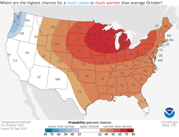 As usual when discussing the next monthly outlook, a good portion of the country is favored to observe a warmer-than-average month. This go-around for the outlook has almost two thirds of the country favored for well above average temperatures in October, an area stretching from the Mountain West to the East Coast. The highest likelihood (60-70%) for a hotter-than-average October is across the western Great Lakes.
In contrast, the forecast for the Pacific Northwest favors a much cooler than average October while there is an equal chance of any of the three outcomes (above, below or near average) for the rest of the West. For once, this is an outlook that does not predict a tilt in the odds towards heat for the West, an area struggling through drought.
As usual when discussing the next monthly outlook, a good portion of the country is favored to observe a warmer-than-average month. This go-around for the outlook has almost two thirds of the country favored for well above average temperatures in October, an area stretching from the Mountain West to the East Coast. The highest likelihood (60-70%) for a hotter-than-average October is across the western Great Lakes.
In contrast, the forecast for the Pacific Northwest favors a much cooler than average October while there is an equal chance of any of the three outcomes (above, below or near average) for the rest of the West. For once, this is an outlook that does not predict a tilt in the odds towards heat for the West, an area struggling through drought.
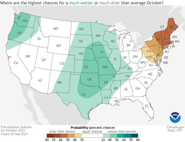 It’s not often to see such a broad area with a tilt in the odds (however large or small) favoring a wetter-than-average month. But this October has just that, as the Mississippi Valley and the Plains stretching from the Canadian to Mexican borders are favored to observe well above average precipitation. The highest likelihood (40-50%) for a wet October is forecast for the central and southern Plains. Meanwhile, out in the Pacific Northwest, there is also a tilt in the odds for a much wetter than average month, coinciding with below-average temperatures.
In contrast, the Northeast is expected to observe a drier-than-average October.
One major area of uncertainty comes with any potential tropical activity during the month. While tropical cyclones in the Atlantic and Gulf of Mexico could easily lead to a wetter-than-average monthly precipitation totals, the other thing to look at is tropical cyclone activity in the Western Pacific Ocean.
As western Pacific tropical cyclones travel to the north and northeast in the Pacific Ocean, they can get absorbed into the flow of the jet stream in the mid-latitudes. This can cause impacts downstream, leading to different patterns of troughs of low pressure and ridges of high pressure that affect monthly temperatures and precipitation. October is the peak month for this sort of behavior in western Pacific typhoons, adding in uncertainty into this month’s forecast.
It’s not often to see such a broad area with a tilt in the odds (however large or small) favoring a wetter-than-average month. But this October has just that, as the Mississippi Valley and the Plains stretching from the Canadian to Mexican borders are favored to observe well above average precipitation. The highest likelihood (40-50%) for a wet October is forecast for the central and southern Plains. Meanwhile, out in the Pacific Northwest, there is also a tilt in the odds for a much wetter than average month, coinciding with below-average temperatures.
In contrast, the Northeast is expected to observe a drier-than-average October.
One major area of uncertainty comes with any potential tropical activity during the month. While tropical cyclones in the Atlantic and Gulf of Mexico could easily lead to a wetter-than-average monthly precipitation totals, the other thing to look at is tropical cyclone activity in the Western Pacific Ocean.
As western Pacific tropical cyclones travel to the north and northeast in the Pacific Ocean, they can get absorbed into the flow of the jet stream in the mid-latitudes. This can cause impacts downstream, leading to different patterns of troughs of low pressure and ridges of high pressure that affect monthly temperatures and precipitation. October is the peak month for this sort of behavior in western Pacific typhoons, adding in uncertainty into this month’s forecast.
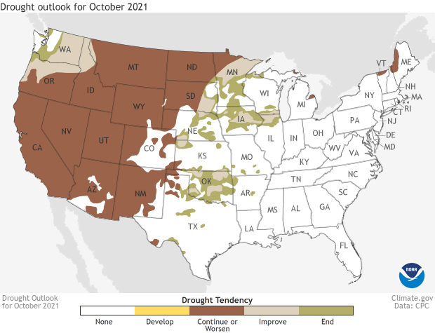 Luckily, rains during the second half of September and forecast in October are likely to stop the flash drought in its tracks leading to drought improvement or removal in October. Similar improvement and removal of drought is likely across the northern Plains in Minnesota, Iowa, Nebraska and western South Dakota, all areas where monthly precipitation totals are favored to be much above average.
Drought across the Pacific Northwest is also expected to become not as severe during the next month as cool, wetter-than-average conditions are expected. Elsewhere across the West, however, drought is expected to persist.
To read the entire discussion of the monthly climate outlooks from the Climate Prediction Center, check out their website. And head back here later this month for a climate recap of September.
Edited for WeatherNation by Mace Michaels
Luckily, rains during the second half of September and forecast in October are likely to stop the flash drought in its tracks leading to drought improvement or removal in October. Similar improvement and removal of drought is likely across the northern Plains in Minnesota, Iowa, Nebraska and western South Dakota, all areas where monthly precipitation totals are favored to be much above average.
Drought across the Pacific Northwest is also expected to become not as severe during the next month as cool, wetter-than-average conditions are expected. Elsewhere across the West, however, drought is expected to persist.
To read the entire discussion of the monthly climate outlooks from the Climate Prediction Center, check out their website. And head back here later this month for a climate recap of September.
Edited for WeatherNation by Mace Michaels
A reminder: the climate outlook maps are not a forecast for the absolute temperature or precipitation amounts in October. Instead, they are the probability (percent chance) that October temperatures or precipitation will be in the upper, middle, or lower third of the climatological record (1991-2020) for October. We refer to these categories as “well above” and “well below” average. The colors (red or blue for temperatures, brown or teal for precipitation) indicate which outcome is the most likely. Darker colors reflect higher chances of a given outcome, not more extreme conditions. Head to the end of this post for more on the math behind the outlooks, including how experts calculate the probability of the less likely (but still possible!) outcomes.
A much warmer than average month for everywhere outside the West
As usual when discussing the next monthly outlook, a good portion of the country is favored to observe a warmer-than-average month. This go-around for the outlook has almost two thirds of the country favored for well above average temperatures in October, an area stretching from the Mountain West to the East Coast. The highest likelihood (60-70%) for a hotter-than-average October is across the western Great Lakes.
In contrast, the forecast for the Pacific Northwest favors a much cooler than average October while there is an equal chance of any of the three outcomes (above, below or near average) for the rest of the West. For once, this is an outlook that does not predict a tilt in the odds towards heat for the West, an area struggling through drought.
A wet forecast for the central Plains
It’s not often to see such a broad area with a tilt in the odds (however large or small) favoring a wetter-than-average month. But this October has just that, as the Mississippi Valley and the Plains stretching from the Canadian to Mexican borders are favored to observe well above average precipitation. The highest likelihood (40-50%) for a wet October is forecast for the central and southern Plains. Meanwhile, out in the Pacific Northwest, there is also a tilt in the odds for a much wetter than average month, coinciding with below-average temperatures.
In contrast, the Northeast is expected to observe a drier-than-average October.
One major area of uncertainty comes with any potential tropical activity during the month. While tropical cyclones in the Atlantic and Gulf of Mexico could easily lead to a wetter-than-average monthly precipitation totals, the other thing to look at is tropical cyclone activity in the Western Pacific Ocean.
As western Pacific tropical cyclones travel to the north and northeast in the Pacific Ocean, they can get absorbed into the flow of the jet stream in the mid-latitudes. This can cause impacts downstream, leading to different patterns of troughs of low pressure and ridges of high pressure that affect monthly temperatures and precipitation. October is the peak month for this sort of behavior in western Pacific typhoons, adding in uncertainty into this month’s forecast.
Drought improvement in the Pacific Northwest, southern and northern Plains
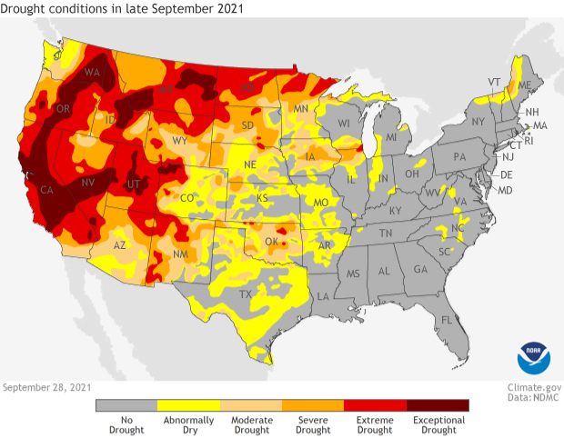
As of the final week of September, nearly 50 percent of the country remains in drought, with over 23 percent in extreme or exceptional (D3 or D4) drought, the two worst categories. Most of the area currently in drought resides out West, where over 93 percent of the region is in drought, including nearly 60 percent in D3 or D4 drought. But during September the other area of drought concern was across Oklahoma as hot and dry conditions lead to flash drought concerns as ground conditions rapidly deteriorated. The state jumped from 6 percent in drought to 73 percent in just three weeks.
Luckily, rains during the second half of September and forecast in October are likely to stop the flash drought in its tracks leading to drought improvement or removal in October. Similar improvement and removal of drought is likely across the northern Plains in Minnesota, Iowa, Nebraska and western South Dakota, all areas where monthly precipitation totals are favored to be much above average.
Drought across the Pacific Northwest is also expected to become not as severe during the next month as cool, wetter-than-average conditions are expected. Elsewhere across the West, however, drought is expected to persist.
To read the entire discussion of the monthly climate outlooks from the Climate Prediction Center, check out their website. And head back here later this month for a climate recap of September.
Edited for WeatherNation by Mace Michaels
All Weather News
More
After Reaching Category 5, Genevieve Weakens in the Pacific
PacificFausto is now a post-tropical cyclone.
30 Jul 2026 11:20 PM

Severe Storm Threat Returns to the Midwest
After several tornadoes ripped through the Mi
30 Jul 2026 9:30 PM


Flooding Risk Increases as Heavy Rain Targets the Tri-State Area
Tuesday, heavy rainfall moved across the Nort
30 Jul 2026 12:25 AM

Severe Weather: Energy From the Midwest Now in the Southeast
UPPER MIDWEST - Through Monday, dangerous tor
29 Jul 2026 10:30 PM

Southeast Flood Risk Lingers Near Stalled Front
A stalled boundary over the Southeast will ke
25 Jul 2026 10:55 AM